The William Jolly Bridge is a heritage-listed road bridge over the Brisbane River between North Quay in the Brisbane CBD and Grey Street in South Brisbane, within City of Brisbane, Queensland, Australia. It was designed by A E Harding Frew and built from 1928 to 1932 by M R Hornibrook Ltd.

The flag of Des Moines, Iowa, was designed by Walter T. Proctor. Set on a blue background is a red vertical stripe along the hoist with the right side of the stripe angling inward toward the hoist and a white balance of three horizontal "bridges."

James Barney Marsh was an American engineer and bridge designer. He patented a new design for arch bridges. Marsh gave Archie Alexander, the first African-American to graduate as an engineer from Iowa State University, his first job. Marsh worked in the bridge building business for over 50 years, and several of his bridges are listed in the National Register of Historic Places.

The Lamar Boulevard Bridge is a historic arch bridge carrying Texas State Highway Loop 343 over Lady Bird Lake in downtown Austin, Texas, United States. The bridge features six open-spandrel concrete arches spanning 659 feet (201 m) and carries tens of thousands of vehicles daily across the lake. Completed in 1942, the Lamar Boulevard Bridge was the second permanent bridge to cross the Colorado River, and one of the last Art Deco-style open-spandrel concrete arch bridges built in Texas. The bridge was named an Austin Landmark in 1993 and added to the National Register of Historic Places in 1994.

The Needham Town Hall Historic District is a historic district on Great Plain Avenue between Highland Avenue and Chapel Street in Needham, Massachusetts. It encompasses Needham Town Hall, a Georgian Revival structure built in 1902 to a design by Winslow & Bigelow, and the grassy public park in front of it, which was established in 1884. The district was listed on the National Register of Historic Places in 1990.

The Sudbury Dam Historic District is a historic district on the southeastern end of Sudbury Reservoir off Massachusetts Route 30 in Framingham and Southborough, Massachusetts. The district encompasses the Sudbury Dam, which impounds the reservoir, and an area encompassing several historic structures located below the dam. The area includes water-supply-related structures from three phases of development of the Greater Boston water supply system. It was listed on the National Register of Historic Places in 1990.

The Des Moines City Hall is a government building in Des Moines, Iowa, built in 1909 and 1910. It was individually listed on the National Register of Historic Places on November 10, 1977 as the Municipal Building, and became a contributing property in the Civic Center Historic District in 1988. The building serves as the seat for the government of the city of Des Moines. Beginning April 7, 2016, City Hall offices were temporarily relocated while the building underwent renovation. The construction was necessary to install modern heating, cooling, and sprinkler systems while preserving the historic character of the building. The project was expected to take 18–24 months. During that time, City Hall was closed to the public, and City offices moved to other nearby locations. Between February 26, 2018 and April 9, 2018, city offices moved back to City Hall.

The Marsh Engineering Company was a company that designed many significant bridges in the United States, including a number that survive and are listed on the National Register of Historic Places. It was located at 206 Masonic Temple in Des Moines, Iowa.

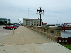
The Court Avenue Bridge is an historic structure located in downtown Des Moines, Iowa, United States. It became a contributing property in the Civic Center Historic District in 1988, and was individually listed on the National Register of Historic Places on May 15, 1998 as a part of the Highway Bridges of Iowa MPS.
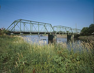
The Southwest Fifth St. Bridge is an historic structure located in downtown Des Moines, Iowa, United States. Built in 1898 after a controversy surrounding the bidding process, it is one of the last Pratt through truss bridges left in an urban setting in Iowa. The bridge was listed on the National Register of Historic Places in 1998 as a part of the Highway Bridges of Iowa MPS.

The Highland Park Historic Business District at Euclid and Sixth Avenues is located in the north-central section of Des Moines, Iowa, United States. It is located on the border of the Oak Park and Highland Park neighborhoods. The commercial historic district has been listed on the National Register of Historic Places since 1998. The Highland Park neighborhood also includes the College Corner Commercial Historic Business District.

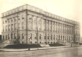
The United States Post Office is an historic building located in Des Moines, Iowa, United States. It was individually listed on the National Register of Historic Places in 1974. It became a contributing property of the Civic Center Historic District when it was established in 1988. It now houses administrative offices for Polk County.
The United States Courthouse, located in Des Moines, Iowa, is the headquarters for the United States District Court for the Southern District of Iowa. It is part of the Civic Center Historic District that was listed on the National Register of Historic Places in 1988.

Blackfriars Bridge is a stone arch bridge in Greater Manchester, England. Completed in 1820, it crosses the River Irwell, connecting Salford to Manchester.

Downtown Des Moines is the central business district of Des Moines, Iowa and the Greater Des Moines Metropolitan Area. Downtown Des Moines is defined by the City of Des Moines as located between the Des Moines River to the east, the Raccoon River to the south, Center Street to the north, and 18th and 15th Streets to the west.

Lacey-Keosauqua State Park is located southwest of Keosauqua, Iowa, United States. The park is located along the Des Moines River in Van Buren County. First dedicated in 1921, it is the largest state park in size in Iowa. In 1990, three areas were named nationally recognized historic districts and listed on the National Register of Historic Places.

The West Broadway Bridge, aka West Street Bridge and the Concrete-Metal Bridge, is a vehicular bridge over the Passaic River in Paterson, New Jersey. It carries West Broadway, traditionally the Paterson-Hamburg Turnpike, and connects to County Route 509 at its west end.

The West Fifth Street Bridge is a historic cantilever concrete girder bridge in downtown Austin, Texas. Built in 1931, the bridge carries Fifth Street across Shoal Creek to link central Austin with neighborhoods that were then the city's western suburbs. It is one of only a handful of curved cantilever girder bridges in Texas, built as part of the city's 1928 master plan for urban development and beautification. The bridge was added to the National Register of Historic Places in 2019.

The Columbus Civic Center is a civic center, a collection of government buildings, museums, and open park space in Downtown Columbus, Ohio. The site is located along the Scioto Mile recreation area and historically was directly on the banks of the Scioto River.

Seattle Municipal Light and Power Plant, also known as Cedar Falls Historic District, is a public hydroelectric plant near North Bend, Washington operated by Seattle City Light. The plant was the first publicly-owned electrical generating plant for Seattle and one of the earliest in the country for a municipality of its size. It was listed on the National Register of Historic Places in 1997.