The White Mountains are a mountain range covering about a quarter of the state of New Hampshire and a small portion of western Maine in the United States. They are part of the northern Appalachian Mountains and the most rugged mountains in New England. The range is heavily visited due to its proximity to Boston and, to a lesser extent, New York City and Montreal, Quebec, Canada.

The Humboldt–Toiyabe National Forest (HTNF) is the principal U.S. National Forest in the U.S. state of Nevada, and has a smaller portion in Eastern California. With an area of 6,289,821 acres (25,454.00 km2), it is the largest National Forest of the United States outside Alaska.

Franconia Notch State Park is located in the White Mountains in northern New Hampshire, United States, and straddles 8 miles (13 km) of Interstate 93 as it passes through Franconia Notch, a mountain pass between the Kinsman Range and Franconia Range. Attractions in the state park include the Flume Gorge and visitor center, the Old Man of the Mountain historical site, fishing in Echo Lake and Profile Lake, and miles of hiking, biking and ski trails. The northern part of the park, including Cannon Mountain and Echo and Profile lakes, is in the town of Franconia, and the southern part, including Lonesome Lake and the Flume, is in Lincoln.

Franconia Notch is a major mountain pass through the White Mountains of New Hampshire. Dominated by Cannon Mountain to the west and Mount Lafayette to the east, it lies principally within Franconia Notch State Park and is traversed by the Franconia Notch Parkway. The parkway required a special act of Congress to sidestep design standards for the Interstate highway system because it is only one lane in each direction.

Mount Osceola is a 4,315-foot (1,315 m) peak within the White Mountains of New Hampshire. Located in the White Mountain National Forest, Mount Osceola is named for the early-19th century Seminole leader. Osceola can be ascended from the Greeley Pond Trail to the northeast of the mountain, which requires crossing the East Peak of Osceola first, or from the Tripoli Road to the south. There was a fire lookout tower at the top of the mountain, which significantly expanded the view from the peak, but it was taken down in the late 1970s. Views from the summit cover a large portion of the White Mountains, extending from Mount Washington in the northeast to the town of Waterville Valley in the south.

The Chemehuevi Mountains are found at the southeast border of San Bernardino County in southeastern California adjacent the Colorado River. Located south of Needles, California and northwest of the Whipple Mountains, the mountains lie in a north-south direction in general, and are approximately 15 miles in length.

The Overmountain Victory National Historic Trail (OVHT) is part of the U.S. National Trails System. It recognizes the Revolutionary War Overmountain Men, Patriots from what is now East Tennessee who crossed the Great Smoky Mountains and then fought in the Battle of Kings Mountain in South Carolina.

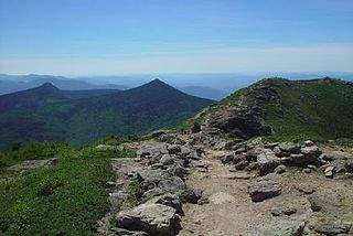
South Carter Mountain is a mountain located in Coos County, New Hampshire. The mountain is part of the Carter-Moriah Range of the White Mountains, which runs along the northern east side of Pinkham Notch. South Carter is flanked to the northeast by Middle Carter Mountain and to the southeast Mount Hight.

Crocker Mountain is a 4,228 ft (1,289 m) peak located in Carrabassett Valley, Franklin County, Maine, in the United States. Crocker Mountain is the fourth highest mountain in the state after the Katahdins and Sugarloaf Mountain, and is part of the Appalachian Mountains. Crocker Mountain is traversed by the Appalachian Trail (AT), a 2,170 mi (3,490 km) National Scenic Trail from Georgia to Maine.

Profile Lake is a 13-acre (53,000 m2) water body located in Franconia Notch in the White Mountains of New Hampshire, at the foot of Cannon Mountain. The lake was given its name due to its location directly beneath the Old Man of the Mountain, a famous rock formation which collapsed in 2003. The lake is near the height of land in Franconia Notch; the lake's outlet is the Pemigewasset River, which flows south to the Merrimack River and ultimately the Gulf of Maine at Newburyport, Massachusetts.

Belknap Mountain is a mountain located in Belknap County, New Hampshire, United States, south of Lake Winnipesaukee. Like the county, the mountain and the associated surrounding Belknap Mountains are named after Jeremy Belknap (1744–1798), a renowned preacher, historian, and author of The History of New Hampshire. The mountain is within Belknap Mountain State Forest.
South Weeks, or Mount Weeks-South Peak, is a mountain located in Coos County, New Hampshire. The mountain is named for US Senator John W. Weeks (1860–1926) of nearby Lancaster, New Hampshire, the sponsor of the Weeks Act of 1911, under which the White Mountain National Forest was established. South Weeks is part of the Pliny Range of the White Mountains. South Weeks is flanked to the northeast by Mount Weeks, and to the southwest by Mount Waumbek.

Black Cap is a mountain located in the town of Conway, New Hampshire, United States. It is located between Kearsarge North Mountain and Peaked Mountain. The rocky summit provides views of Maine and New Hampshire's White Mountains.

The Gila Mountains of Graham County are a mountain range in central-east Arizona. It borders the Gila River and Gila Valley on the valley's northeast in north-central Graham County; also the San Carlos Indian Reservation. The mountain range sits on the southern perimeter of the White Mountains and is located in the southeast area of Arizona's transition zone.
White Rock, 2,550 feet (780 m), is the high point on a 7 mi (11 km) ridgeline in the Taconic Mountains. The ridge is located in the tri-state corner of New York, Massachusetts, and Vermont in the towns of Petersburgh, Williamstown, and Pownal. The ridge has several distinct knobs; those with names are, from south to north: White Rocks, 2,365 feet (721 m); Smith Hill, 2,330 feet (710 m); White Rock, the high point 2,550 feet (780 m); and Bald Mountain 2,485 feet (757 m). The Snow Hole, located along the ridgeline between Bald Mountain and the White Rock, is a crevasse in which snow can be found well into the summer.
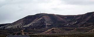
White Mountain is a long mountain located in central Sweetwater County, Wyoming, near the cities of Rock Springs and Green River. The mountain is part of the Green River Formation, and contains communications towers that serve a number of purposes. Hundreds of carved figures also dot the sandstone cliffs at the White Mountain Petroglyph site and range from 200 to 1000 years old. Pilot Butte, located on top of White Mountain, is accessible from roads on the mountain.

Paris Mountain State Park is located five miles (8 km) north of Greenville, South Carolina. Activities available in the 1,540-acre (6 km2) park include hiking, biking, swimming and picnicking. The 13-acre (52,609 m2) Lake Placid offers swimming and fishing. Canoes, kayaks, and pedal boats are seasonally available for rental; private boats are not permitted. Camping is allowed and campsites range from rustic, back country sites to paved sites with water and electricity hook-ups. The park's Civilian Conservation Corps (CCC) structures, including the Camp Buckhorn lodge, are listed on the National Register of Historic Places. m.

The White Cloud Mountains are part of the Rocky Mountains of the western United States, located in central Idaho, southeast of Stanley in Custer County. The range is located within the Sawtooth National Recreation Area (SNRA) and partially within the Cecil D. Andrus–White Clouds Wilderness.

The Siffleur Wilderness Area is a provincially designated wilderness area in the Canadian Rockies of Alberta. It was established in 1961 and it, as one of the three wilderness areas of Alberta, has the strictest form of government protection available in Canada. All development is forbidden and only travel by foot is permitted. Hunting and fishing are not allowed. The other two wilderness areas are White Goat Wilderness Area and Ghost River Wilderness Area and together the three areas total 249,548.80 acres (100,988.82 ha).

The Kinsman Range, also known as the Cannon–Kinsman Range, is located in the White Mountains of New Hampshire in the United States. The highest point in the north-south range is 4,358-foot-high (1,328 m) Kinsman Mountain, followed by the 4,293-foot (1,309 m) North Peak of Kinsman, and 4,080-foot (1,240 m) Cannon Mountain, one of the richest in rock climbing routes in the Whites. All are official "Four-thousand footers". 3,478-foot (1,060 m) Mount Wolf is on the crest of the range south of Kinsman Mountain. Rounding out the range is 2,470-foot (750 m) Bald Peak on the west side of Kinsman Mountain.


