
The term "United States," when used in the geographic sense, refers to the contiguous United States, Alaska, Hawaii, the five insular territories of Puerto Rico, Northern Mariana Islands, U.S. Virgin Islands, Guam, American Samoa, and minor outlying possessions. The United States shares land borders with Canada and Mexico and maritime borders with Russia, Cuba, the Bahamas, and many other countries, mainly in the Caribbeanin addition to Canada and Mexico. The northern border of the United States with Canada is the world's longest bi-national land border.
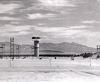
Jackass Flats is a shallow alluvial basin located in the southwest portion of the Nevada National Security Site in Nye County, Nevada, United States. The area lies east of Yucca Mountain, south of the Calico Hills and Shoshone Mountain and northwest of Skull Mountain. The valley drains to the southwest via the Tonopah and Fortymile washes into the Amargosa Valley across US Route 95 at the town of Amargosa Valley, Nevada. The "flat" covers an area of approximately 120 square miles (310 km2) and ranges in elevation from about 2,800 ft (850 m) just north of US 95 to 4,000 ft (1,200 m) at the mountain bases to the north and east.

Flat Tops Wilderness Area is the second largest U.S. Wilderness Area in Colorado. It is 235,214 acres (951.88 km2), with 38,870 acres (157.3 km2) in Routt National Forest and 196,344 acres (794.58 km2) in White River National Forest. It was designated a wilderness area in 1975. Trappers Lake, located in the north of the area, was the lake that inspired Arthur Carhart, a United States Forest Service official, to plead for wilderness preservation.

Frozen Head State Park and Natural Area is a state park in Morgan County, Tennessee, in the southeastern United States. The park, situated in the Crab Orchard Mountains between the city of Wartburg and the community of Petros, contains some of the highest mountains in Tennessee west of the Blue Ridge Mountains.

Looking Glass Rock is a pluton monolith in the Appalachian Mountains of western North Carolina, United States.

House Mountain is a mountain located in Corryton, Tennessee, United States, about 8 miles (13 km) northeast of Knoxville. Rising to an elevation of 2,064 feet (629 m) above sea level, House Mountain is the highest point in Knox County.

Devils Head is a mountain summit in the Rampart Range of the Rocky Mountains of Colorado. The 9,749-foot (2,971 m) peak is located in Pike National Forest, 14.2 miles (22.9 km) southwest by south of the community of Sedalia in Douglas County, Colorado, United States.
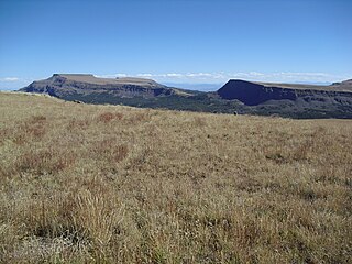
Flat Top Mountain is the highest summit of the Flat Tops in the Rocky Mountains of North America. The prominent 12,361-foot (3,768 m) peak is located in the Flat Tops Wilderness, 19.1 miles (30.7 km) south-southwest of the Town of Oak Creek, Colorado, United States, on the drainage divide between Routt National Forest and White River National Forest. The summit of Flat Top Mountain is the highest point in Garfield County, Colorado.
Flat Top is an unincorporated community in Mercer County, West Virginia, United States. Flat Top is located on U.S. Route 19, 19 miles (31 km) south of Beckley.
Mingo — sometimes known as Mingo Flats — is an unincorporated community in Randolph County, West Virginia, United States. It is located on U.S. Route 219, 15.5 miles (24.9 km) south-southwest of Huttonsville. It is named for the historic Iroquoian Mingo people.

The Mountain states form one of the nine geographic divisions of the United States that are officially recognized by the United States Census Bureau. It is a subregion of the Western United States.

Skull Valley is a 40-mile (64 km) long valley located in east Tooele County, Utah, United States at the southwest of the Great Salt Lake. The valley trends north–south, but turns slightly northeast to meet Stansbury Bay,.
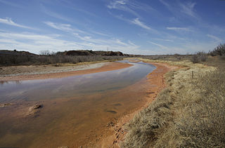
The Salt Fork Brazos River is a braided, highly intermittent stream about 150 mi (240 km) long, heading along the edge of the Llano Estacado about 26 mi (42 km) east-southeast of Lubbock, Texas. From its source, it flows generally east-southeastward to join the Double Mountain Fork to form the Brazos River about 18 mi (29 km) west-northwest of Haskell, Texas. The Salt Fork stretches across portions of Crosby, Garza, Kent, and Stonewall counties of West Texas.
Pine Mountain Valley is located in Harris County, Georgia, United States. Its ZIP code is 31823.
Schultice Mountain is a mountain located in the Catskill Mountains of New York south-southwest of Grand Gorge. Hack Flats is located south and Irish Mountain is located north of Schultice Mountain.
White Man Mountain is a mountain located in the Catskill Mountains of New York south-southwest of Grand Gorge. Hack Flats is located east of White Man Mountain and Red Mountain is located south.
Cator Roundtop is a mountain located in the Catskill Mountains of New York south-southwest of Grand Gorge. Hack Flats is located northeast, Red Kill Ridge is located southeast, and Red Mountain is located northeast of Cator Roundtop.
Roundtop is a mountain located in the Catskill Mountains of New York east-northeast of Roxbury. Hack Flats is located west-southwest, Negro Hill is located north, and Bearpen Mountain is located southeast of Roundtop.
Richtmyer Peak is a mountain in Greene County, New York and partly in Schoharie County, New York. It is located in the Catskill Mountains southwest of West Durham. Mount Pisgah is located east, and Richmond Mountain is located southwest of Richtmyer Peak.

The San Luis Hills are a group of small mountain ranges in Conejos and Costilla counties in the San Luis Valley in southern Colorado. The individual mountain ranges that make up the San Luis Hills include the Fairy Hills, the Brownie Hills, the Piñon Hills, and the South Piñon Hills. The San Luis Hills' highest point is Flat Top, elevation 9,206 feet.

