
The Himalayas, or Himalaya, , is a mountain range in Asia separating the plains of the Indian subcontinent from the Tibetan Plateau. The range has many of Earth's highest peaks, including the highest, Mount Everest (Nepal/China). The Himalayas include over fifty mountains exceeding 7,200 m (23,600 ft) in elevation, including ten of the fourteen 8,000-metre peaks. By contrast, the highest peak outside Asia is 6,961 m (22,838 ft) tall.

Ooty, officially known as Udagamandalam, is a town and a municipality in the Niligiris District of the Indian state of Tamil Nadu. It is located 86 km north of Coimbatore and 128 km south of Mysore and is the headquarters of the Nilgiris district. It is a popular hill station located in the Nilgiri Hills. Local Residents call it Blue Hills.

Indian Lake is a town in Hamilton County, New York, United States. The population was 1,352 at the 2010 census. The name is from a lake of the same name that is largely inside the town. There are no permanent stop lights in the town. Law enforcement is provided by New York State Troopers and Hamilton County Sheriff's Office.

Wells is a town in Hamilton County, New York, United States. The population was 674 at the 2010 census. The town is named after Joshua Wells, a land agent, who built the first mills in the area. It is in the Adirondack Park and on the eastern border of the county. It is northwest of Schenectady.
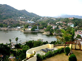
Mount Abu is a hill station in the Aravalli Range in Pindwara - Abu Assembly Constituency Of Sirohi district of Rajasthan state in western India, near the border with Gujarat. The mountain forms a rocky plateau 22 km long by 9 km wide. The highest peak on the mountain is Guru Shikhar at 1,722 m (5,650 ft) above sea level. It is referred to as 'an oasis in the desert' as its heights are home to rivers, lakes, waterfalls and evergreen forests. The nearest train station is Abu Road railway station: 28 km away.

Yercaud is a Hill station in Salem District, in Tamil Nadu, India. It is located in the Shevaroys range of hills in the Eastern Ghats. It is situated at an altitude of 1515 metres (4970 ft) above sea level, and the highest point in Yercaud is the Servarayan temple, at 5,326 feet (1,623 m).
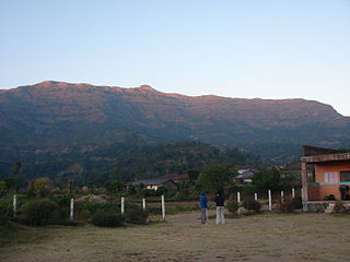
Kalsubai is a mountain in the Western Ghats, located in the Indian state of Maharashtra. Its summit situated at an elevation of 1646 metres is the highest point in Maharashtra.

Aralvaimozhi is a panchayat town in Kanniyakumari District in the state of Tamil Nadu, India. It is a small town situated in southern India.
The Franklin Lakes Public Schools are a community public school district serving students in pre-kindergarten through eighth grade from Franklin Lakes, in Bergen County, New Jersey, United States.

Morni is a village and tourist attraction in the Morni Hills at the height of 1,267 metres (4,157 ft) in the Panchkula district of the Indian state of Haryana. It is located around 45 kilometres (28 mi) from Chandigarh, 35 kilometres (22 mi) from Panchkula city and is known for its Himalayan views, flora, and lakes. The name of Morni is believed to derive from a queen who once ruled the area two thousand years back. She was a just and noble ruler of her Queendom.

The West Canada Lake Wilderness Area is an Adirondack Park Forest Preserve management unit in the State of New York, USA.

The Middle Fork Willamette River is one of several forks that unite to form the Willamette River in the western part of the U.S. state of Oregon. It is approximately 115 miles (185 km) long, draining an area of the Cascade Range southeast of Eugene, which is at the southern end of the Willamette Valley.
Indian Mountain State Park is a state park in Campbell County, Tennessee, in the southeastern United States. Established in 1971, the park consists of 213 acres (0.86 km2) situated at the base of Indian Mountain, a 1,949-foot (594 m) summit that overlooks the Elk Valley in the Cumberland Mountains. The park is located immediately west of the city of Jellico, and the history and development of the two are intertwined to a great extent.
Turtle Mountain Indian Reservation is a reservation located in northern North Dakota, United States. It is the land base for the Turtle Mountain Band of Chippewa Indians. The population of the Turtle Mountain Indian Reservation consists of Plains Ojibwe and Métis and was first established in 1882.

The Paugussett Trail is a 9.2-mile (14.8 km) Blue-Blazed hiking trail "system" in the lower Housatonic River valley in Fairfield County and, today, is entirely in Shelton and Monroe, Connecticut. Much of the trail is in Indian Well State Park and the Town of Monroe's Webb Mountain Park. The mainline trail is primarily southeast to northwest with three short side or spur trails.

The Albion Mountains are a mountain range in the U.S. states of Idaho (~99%) and Utah (~1%), spanning Cassia County, Idaho and barely reaching into Box Elder County, Utah. The highest point in the range is Cache Peak at 10,339 feet (3,151 m), and the range is a part of the Great Basin Divide and the Basin and Range Province. Most of the mountains are part of the Albion Division of the Minidoka Ranger District of Sawtooth National Forest.

Northeast India consists of the eight states Arunachal Pradesh, Assam, Manipur, Meghalaya, Mizoram, Nagaland, Sikkim and Tripura. Tourism in this area is based around the unique Himalayan landscape and culture distinct from the rest of India.

Rum Hill is a mountain located in Central New York Region of New York northwest of the Hamlet of Pierstown. Red House Hill is located southeast, Metcalf Hill is located south, Allen Lake and Mohegan Hill are located north-northwest and Otsego Lake is located east of Rum Hill.

Bell Mountain is a mountain located in Adirondack Mountains of New York located in the Town of Indian Lake east of Indian Lake.
Fox Hill is a mountain located in Adirondack Mountains of New York located in the Town of Indian Lake east of Indian Lake.

