Winona, Arizona

Last updated

Winona, Arizona
Here is a Neat Roger Puta Sequence (28547839426).jpg
A freight train passing through Darling
Coconino County incorporated areas Winona highlighted.svg
Location in Coconino County and the state of Arizona
Coordinates: 35°12′18″N111°24′30″W / 35.20500°N 111.40833°W / 35.20500; -111.40833
Country United States
State Arizona
Counties Coconino
Elevation
[1]
6,263 ft (1,909 m)
Time zone UTC-7 (MST)
Area code 928
FIPS code 04-83860
GNIS feature ID36324 [1]

Winona is a small populated place in Coconino County in the northern part of the U.S. state of Arizona. [1] At one time it was also called Walnut, and Winona's railroad station was renamed Darling in honor of an engineer.

Contents

History

Winona was once an incorporated village called Walnut Creek, until the 1950s when it became part of Flagstaff. Walnut Creek runs through Winona. It has been a dry creek bed since a dam was built above Walnut Canyon in the 1950s to provide Flagstaff with a reservoir. Before this, the creek ran year round.[ citation needed ]

Railroad

Winona train station was renamed on 6 December 1959 as "Darling" after William B. Darling, a local railroad engineer. [2] [3] [4] Darling Cinder Pit to the north east of Winona is also named after him. [5]

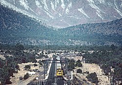
The history of Darling is tied directly to the railroad that crosses through it. The Southwest Chief has been a regular visitor [6] [7] and for many years it was served by the Santa Fe Railway. [8] [9] [10]

In October 2019 a Burlington Northern freight train derailed there, disrupting both freight traffic, intermodal freight [11] and passenger train traffic on Amtrak. [12] [13]

Winona Bridge, which is no longer accessible by car WinonaBridge WinonaAZ.jpg
Winona Bridge, which is no longer accessible by car

Winona is located along Interstate 40 (old U.S. Route 66), and the otherwise-obscure town was made famous due to its inclusion in the lyrics to the song "(Get Your Kicks on) Route 66". It lies about thirteen miles (21 km) east of Flagstaff, meaning that it is out of sequence with the rest of the cities named in the song because of its near-miss: "Don't forget Winona."

The singer Wynonna Judd adopted her name upon hearing "Winona" in "Route 66." [14]

Related Research Articles

<span class="mw-page-title-main">BNSF Railway</span> American freight railroad

BNSF Railway is the largest freight railroad in the United States. One of six North American Class I railroads, BNSF has 36,000 employees, 33,400 miles (53,800 km) of track in 28 states, and over 8,000 locomotives. It has three transcontinental routes that provide rail connections between the western and eastern United States. BNSF trains traveled over 169 million miles in 2010, more than any other North American railroad.

<span class="mw-page-title-main">Burlington Northern Railroad</span> Former American railroad company

The Burlington Northern Railroad was a United States-based railroad company formed from a merger of four major U.S. railroads. Burlington Northern operated between 1970 and 1995.

<i>Southwest Chief</i> Amtrak service between Chicago and Los Angeles

The Southwest Chief is a long-distance passenger train operated by Amtrak on a 2,265-mile (3,645 km) route between Chicago and Los Angeles through the Midwest and Southwest via Kansas City, Albuquerque, and Flagstaff mostly on the BNSF's Southern Transcon, but branches off between Albuquerque and Kansas City via the Topeka, La Junta, Raton, and Glorieta Subdivision. Amtrak bills the route as one of its most scenic, with views of the Painted Desert and the Red Cliffs of Sedona, as well as the plains of Illinois, Missouri, Kansas, and Colorado.

<span class="mw-page-title-main">Cajon Pass</span> Mountain pass in Southern California

Cajon Pass is a mountain pass between the San Bernardino Mountains to the east and the San Gabriel Mountains to the west in Southern California. Created by the movements of the San Andreas Fault, it has an elevation of 3,777 ft (1,151 m). Located in the Mojave Desert, the pass is an important link from the Greater San Bernardino Area to the Victor Valley, and northeast to Las Vegas. The Cajon Pass area is on the Pacific Crest Trail.

<span class="mw-page-title-main">EMD SDP40F</span> Class of diesel passenger locomotives

The EMD SDP40F was a six-axle 3,000 hp (2.2 MW) C-C diesel–electric locomotive built by General Motors Electro-Motive Division (EMD) from 1973 to 1974. Based on Santa Fe's EMD FP45, EMD built 150 for Amtrak, the operator of most intercity passenger trains in the United States. Amtrak, a private company but funded by the United States government, had begun operation in 1971 with a fleet of aging diesel locomotives inherited from various private railroads. The SDP40F was the first diesel locomotive built new for Amtrak and for a brief time they formed the backbone of the company's long-distance fleet.

<span class="mw-page-title-main">GE Dash 8-40BW</span>

The Dash 8-40BW, or B40-8W, is a four-axle diesel locomotive built by GE Transportation for the Atchison, Topeka and Santa Fe Railway (ATSF) in the late 1980s and the early 1990s. It is part of the GE Dash 8 Series of freight locomotives.

<span class="mw-page-title-main">Corwith Yard</span> Railroad freight terminal in Chicago, Illinois

Corwith Yards is a railroad intermodal freight terminal located at Pershing Road & Kedzie Avenue in the southwest side of Chicago, Illinois, in the neighborhood of Brighton Park. At the time it was built by the Atchison, Topeka and Santa Fe Railway in 1888, it was the world's largest railway yard. With adjacent parking and buildings it covers nearly a square mile of land. In the late 19th century Corwith Yards was the end of the line for trains of livestock loaded at AT&SF stations such as Dodge City, Kansas, and bound for the Union Stock Yards, as well as grain and other cargo from the western United States.

<span class="mw-page-title-main">Toledo, Peoria and Western Railway</span> Short-line railroad in Illinois & Indiana

The Toledo, Peoria and Western Railway is a short line railroad that operates 247 miles (398 km) of track from Mapleton, Illinois, through Peoria across Illinois to Logansport, Indiana. TP&W has trackage rights between Galesburg, Illinois, and Peoria, between Logansport and Kokomo, Indiana, and between Reynolds, Indiana, and Lafayette, Indiana. TPW has connections with UP, BNSF, NS, CSXT, CN, CP, BL, CERA, CIM, KBSR and T&P. The railroad is now owned by Genesee & Wyoming Inc. The railroad's traffic comes largely from agricultural products, including both raw and processed grain products, as well as chemicals and completed tractors. The TPW hauled around 26,000 carloads in 2008.

<span class="mw-page-title-main">Santa Fe Depot (San Diego)</span> Main railroad station for San Diego

Santa Fe Depot is a union station in San Diego, California, built by the Atchison, Topeka and Santa Fe Railway to replace the small Victorian-style structure erected in 1887 for the California Southern Railroad Company. The Spanish Colonial Revival style station is listed on the National Register of Historic Places and is a San Diego Historic Landmark. Its architecture, particularly the signature twin domes, is often echoed in the design of modern buildings in downtown San Diego.

<span class="mw-page-title-main">Flagstaff station</span> Historic railroad station in Coconino County, Arizona

Flagstaff station is an Amtrak train station at 1 East Route 66 in Flagstaff, Arizona. The station, formerly an Atchison, Topeka and Santa Fe Railway depot, doubles as a visitor center and rental-car pickup and is located in downtown Flagstaff. Northern Arizona University is located nearby, as are the Lowell Observatory, Sunset Crater, the Walnut Canyon National Monument, ski resorts and other attractions. It is also the closest Amtrak station to Grand Canyon National Park.

<span class="mw-page-title-main">Southern Transcon</span> Rail corridor owned by BNSF Railway

The Southern Transcon is a main line of the BNSF Railway comprising 11 subdivisions between Southern California and Chicago, Illinois. Completed in its current alignment in 1908 by the Atchison, Topeka and Santa Fe Railway, when it opened the Belen Cutoff in New Mexico and bypassed the steep grades of Raton Pass, it now serves as a mostly double-tracked intermodal corridor.

<span class="mw-page-title-main">Arizona and California Railroad</span> Short line railroad in the Southwestern United States

The Arizona and California Railroad is a class III short line railroad that was a subdivision of the Atchison, Topeka and Santa Fe Railway (ATSF). The ARZC began operations on May 9, 1991, when David Parkinson of the ParkSierra RailGroup purchased the line from the Santa Fe Railway. ParkSierra Railgroup was purchased in January 2002 by shortline railroad holding company RailAmerica. The Genesee & Wyoming shortline railroad holding company purchased RailAmerica in December 2012. ARZC's main commodities are petroleum gas, steel, and lumber; the railroad hauls around 12,000 carloads per year.

<span class="mw-page-title-main">Galesburg station (Atchison, Topeka and Santa Fe Railway)</span>

Galesburg Santa Fe Station was a railway station in the west central Illinois town of Galesburg. The station was along the Atchison, Topeka and Santa Fe Railway's main line and served trains such as the Super Chief and El Captain. After Amtrak took over intercity rail in the United States, it was served by trains such as the Lone Star (1971–1979) and the Southwest Chief (1971–1996).

<span class="mw-page-title-main">Ash Fork station</span> Former railway station in Arizona, U.S.

Ash Fork Station is a former railway station of the Atchison, Topeka and Santa Fe Railway, located in Ash Fork, Yavapai County, Arizona. The large and "grand" Harvey House Escalante Hotel and restaurant were part of the station complex.

The Cameron connector is a section of track built in 1995–1996 near Cameron, Illinois, that connects the former Burlington Northern Railroad and the former Atchison, Topeka and Santa Fe Railway tracks, both which are now part of the BNSF Railway.

Cosnino is a populated place situated in Coconino County, Arizona, United States, located several miles east of Flagstaff, the county seat.

The Chillicothe Subdivision or "Chillicothe Sub" is a railway line running about 229 miles (369 km) from Chicago, Illinois to Fort Madison, Iowa in the United States of America. It is operated by BNSF Railway as part of their Southern Transcon route from Chicago to Los Angeles. The Chillicothe Subdivision is a high volume route connecting three principal yards in Chicago in the east and the Marceline Subdivision in the west which continues to Kansas City.

Barstow Yard is a classification yard operated by Burlington Northern Santa Fe Railway (BNSF) in Barstow, California. With 48 directional tracks and a total area of approximately 600 acres (240 ha), it is the second largest classification yard west of the Rocky Mountains after the JR Davis Yard. Today, almost all freight traffic to and from Southern California runs through the junction.

References

  1. 1 2 3 U.S. Geological Survey Geographic Names Information System: Winona, Arizona
  2. "Dinner Honors William B. Darling". Arizona Daily Sun. September 29, 1958. Retrieved January 14, 2020.
  3. Cook, James B. (April 15, 1973). "The Super C". Arizona Republic.
  4. The Santa Fe Magazine, vol. 53, 1959, p. 46
  5. "The Santa Fe, a partner in progress". Arizona Daily Sun. March 27, 1976.
  6. "Southwest Chief". RailNews . 404–409. Pasadena, California: Pentrex: 76. the Southwest Chief, rolls through Darling, Arizona, on Sept. 20, 1996.
  7. Schmollinger, Steve. Images of Western Railroading. Voyageur Press. p. 153. ISBN   9781610604123.
  8. Lawrence, Elrond G. (2008). Route 66 Railway: The Story of Route 66 and the Santa Fe Railway in the American Southwest. Los Angeles Railroad Heritage Foundation. p. 107.
  9. "Railfan and Railroad". 11. Carstens Publications. 1992: 20.{{cite journal}}: Cite journal requires |journal= (help)
  10. "ATSF Railway train symbol VLAKC at West Darling, Arizona". CarrTracks. Retrieved January 16, 2020. Santa Fe train VLAKC approaches the old US highway 66 bridge at Darling, AZ early in the morning of February 21, 1988. In the background are the San Francisco Mountains. Humphreys Peak is the highest point in Arizona at 12,670 feet. Disk 68
  11. "BNSF Darling, AZ Derailment Disrupts Intermodal Service to/from CA and AZ". October 15, 2019. Retrieved January 13, 2020. ... October 14, 2019, BNSF received a preliminary report that a non-intermodal train derailed near Darling, AZ, blocking both main lines to/from California and Arizona. ...BNSF does not have an alternate route available. As a result, customers should expect delays of 24-72 hours on shipments moving to/from California and Arizona. Due to the severity of this service interruption during domestic peak season, equipment availability may also be temporarily disrupted in some markets. J.B. Hunt will continue to monitor the situation and provide updates as they become available.
  12. Buffon, Scott (October 14, 2019). "Freight train derails east of Flagstaff, closes tracks indefinitely". Arizona Daily Sun . Retrieved January 13, 2020.
  13. "Customer Notifications Final Report: Train Derailment near Darling, Arizona (Seligman Subdivision)". Burlington Northern Santa Fe Railroad. October 14, 2019. Retrieved January 13, 2020. ... we received a preliminary report of a train derailment near Darling, AZ which has affected both main tracks. Darling, AZ is approximately 15 miles east of Flagstaff, AZ. Main track 2 was returned to service October 15, 2019 at 11:40 a.m. CT and Main track 1 was returned to service October 15, 2019...
  14. Wynnona Judd - Country Artist Country Music Performers