Åseral

Last updated • 4 min readFrom Wikipedia, The Free Encyclopedia
Åseral Municipality
Åseral kommune
Aaseral herred  (historic name)
Aaserald herred  (historic name)
Norway Counties Agder Position.svg
Agder within Norway
NO 4224 Aseral.svg
Åseral within Agder
Coordinates: 58°42′07″N07°23′37″E / 58.70194°N 7.39361°E / 58.70194; 7.39361
Country Norway
County Agder
District Sørlandet
Established1 Jan 1838
  Created as Formannskapsdistrikt
Administrative centre Kyrkjebygda
Government
  Mayor (2019) Inger Lise Lund Stulien (Ap)
Area
  Total
887.50 km2 (342.67 sq mi)
  Land796.96 km2 (307.71 sq mi)
  Water90.54 km2 (34.96 sq mi)  10.2%
  Rank#131 in Norway
Population
 (2023)
  Total
911
  Rank#338 in Norway
  Density1.1/km2 (3/sq mi)
  Change (10 years)
Decrease2.svg −0.1%
Demonym Åsdøl [1]
Official language
[2]
   Norwegian form Nynorsk
Time zone UTC+01:00 (CET)
  Summer (DST) UTC+02:00 (CEST)
ISO 3166 code NO-4224 [3]
Website Official website

Åseral is a municipality in Agder county, Norway. It is in the traditional district of Sørlandet. The administrative centre of the municipality is the village of Kyrkjebygda. Other villages in Åseral include Eikerapen, Kylland, Ljosland, and Åknes.

Contents

Åseral is an inland municipality, bordering Bygland municipality to the north and east, Evje og Hornnes to the east, Lyngdal to the south, Hægebostad to the southwest, and Kvinesdal in the west. Åseral is the headwaters of the river Mandalselva and the Mandalen valley.

The local folk museum in Aseral has preserved many historic farm buildings NF65 Hoybu fra Haupelid I.jpg
The local folk museum in Åseral has preserved many historic farm buildings

The 888-square-kilometre (343 sq mi) municipality is the 131st largest by area out of the 356 municipalities in Norway. Åseral is the 338th most populous municipality in Norway with a population of 911. The municipality's population density is 1.1 inhabitants per square kilometre (2.8/sq mi) and its population has decreased by 0.1% over the previous 10-year period. [4] [5]

General information

Skjerka power station, a source of power in Aseral Skjerka kraftverk.JPG
Skjerka power station, a source of power in Åseral
Ljosland fjellstove hotel in Aseral is part of the local tourism industry Ljosland Fjellstove 2010.JPG
Ljosland fjellstove hotel in Åseral is part of the local tourism industry
Aseral Church is the main church for the municipality. Aseral kirke.jpg
Åseral Church is the main church for the municipality.

For centuries, the large parish of Bjelland encompassed the northern half of the Mandalen valley. The northern annex of the parish was Aaserald which was in the neighboring county of Nedenes while the main part of the parish was in Lister og Mandal county. When the formannskapsdistrikt law went into effect on 1 January 1838, each parish was created as a municipality, however, since Bjelland covered areas in two counties, it had to be split into two municipalities. The northern annex became the municipality of Aaserald (later spelled Åseral) in Nedenes county and the rest became the municipality of Bjelland og Grindum in Lister og Mandal county. On 1 September 1880, the municipality of Åseral was transferred from Nedenes county to Lister og Mandal county. Its municipal boundaries have never changed. [6]

Name

The municipality (originally the parish) is named after the old name for the area (Old Norse : Ásaráll). The meaning of the name is somewhat uncertain. One theory is that the first element comes from the word áss which refers to "Æsir", the old pagan Norse gods and the last element is áll (Old Norse) or alhs (Gothic) which means "gods' temple". Another theory is that the first element the genitive case of the word áss which means "hill" or "mountain ridge" and the last element is áll which means "long strip" or "eel-shaped", which likely refers to the long, narrow lake Øre which is surrounded by mountains and hills. Historically, the name was spelled Aaserald or Aaseral. [7] On 21 December 1917, a royal resolution enacted the 1917 Norwegian language reforms. Prior to this change, the name was spelled Aaseral with the digraph "Aa", and after this reform, the name was spelled Åseral, using the letter Å instead. [8] [9]

Coat of arms

The coat of arms was granted on 20 January 1989. The official blazon is "Vert, a horseshoe argent" (Norwegian : På grøn grunn ein sølv hestesko). This means the arms have a green field (background) and the charge is a horseshoe. The horseshoe has a tincture of argent which means it is commonly colored white, but if it is made out of metal, then silver is used. The green color in the field symbolizes the importance of forestry and the horseshoe was chosen to represent the historical importance of horses in the farming culture of Åseral as well as the symbol of good luck. The arms were designed by Ulf Dreyer. The municipal flag has the same design as the coat of arms. [10] [11] [12] [13] [14]

Churches

The Church of Norway has one parish (sokn) within the municipality of Åseral. It is part of the Otredal prosti (deanery) in the Diocese of Agder og Telemark. Until 2019, it was part of the old Mandal prosti.

Churches in Åseral
Parish (sokn)Church nameLocation of the churchYear built
Åseral Åseral Church Kyrkjebygda 1822
Ljosland Chapel Ljosland 1959
Åknes Chapel Åknes 1873

Government

Åseral Municipality is responsible for primary education (through 10th grade), outpatient health services, senior citizen services, welfare and other social services, zoning, economic development, and municipal roads and utilities. The municipality is governed by a municipal council of directly elected representatives. The mayor is indirectly elected by a vote of the municipal council. [15] The municipality is under the jurisdiction of the Agder District Court and the Agder Court of Appeal.

Municipal council

The municipal council (Kommunestyre) of Åseral is made up of 17 representatives that are elected to four year terms. The tables below show the current and historical composition of the council by political party.

Åseral kommunestyre 20232027 [16]   
Party name (in Nynorsk)Number of
representatives
  Labour Party (Arbeidarpartiet)6
  Conservative Party (Høgre)3
  Christian Democratic Party (Kristeleg Folkeparti)4
  Centre Party (Senterpartiet)4
Total number of members:17
Åseral kommunestyre 20192023 [17]   
Party name (in Nynorsk)Number of
representatives
  Labour Party (Arbeidarpartiet)6
  Conservative Party (Høgre)3
  Christian Democratic Party (Kristeleg Folkeparti)3
  Centre Party (Senterpartiet)5
Total number of members:17
Åseral kommunestyre 20152019 [18]   
Party name (in Nynorsk)Number of
representatives
  Labour Party (Arbeidarpartiet)3
  Conservative Party (Høgre)4
  Christian Democratic Party (Kristeleg Folkeparti)4
  Centre Party (Senterpartiet)6
Total number of members:17
Åseral kommunestyre 20112015 [19]   
Party name (in Nynorsk)Number of
representatives
  Labour Party (Arbeidarpartiet)4
  Conservative Party (Høgre)2
  Centre Party (Senterpartiet)8
  Cross-party local list (Tverrpolitisk bygdeliste)3
Total number of members:17
Åseral kommunestyre 20072011 [18]   
Party name (in Nynorsk)Number of
representatives
  Labour Party (Arbeidarpartiet)3
  Conservative Party (Høgre)2
  Christian Democratic Party (Kristeleg Folkeparti)4
  Centre Party (Senterpartiet)4
  Cross-party local list (Tverrpolitisk bygdeliste)4
Total number of members:17
Åseral kommunestyre 20032007 [18]   
Party name (in Nynorsk)Number of
representatives
  Labour Party (Arbeidarpartiet)3
  Christian Democratic Party (Kristeleg Folkeparti)4
 Joint list of the Conservative Party (Høgre) and the Centre Party  (Senterpartiet)4
  Cross-party local list (Tverrpolitisk bygdeliste)6
Total number of members:17
Åseral kommunestyre 19992003 [18]   
Party name (in Nynorsk)Number of
representatives
  Labour Party (Arbeidarpartiet)2
  Christian Democratic Party (Kristeleg Folkeparti)4
 Joint list of the Conservative Party (Høgre) and the Centre Party  (Senterpartiet)3
  Cross-party local list (Tverrpolitisk bygdeliste)8
Total number of members:17
Åseral kommunestyre 19951999 [20]   
Party name (in Nynorsk)Number of
representatives
  Labour Party (Arbeidarpartiet)2
  Conservative Party (Høgre)1
  Christian Democratic Party (Kristeleg Folkeparti)3
  Centre Party (Senterpartiet)2
  Åseral local list (Åseral bygdeliste)9
Total number of members:17
Åseral kommunestyre 19911995 [21]   
Party name (in Nynorsk)Number of
representatives
  Labour Party (Arbeidarpartiet)4
  Conservative Party (Høgre)2
  Christian Democratic Party (Kristeleg Folkeparti)3
  Centre Party (Senterpartiet)6
  Åseral local list (Åseral bygdeliste)2
Total number of members:17
Åseral kommunestyre 19871991 [22]   
Party name (in Nynorsk)Number of
representatives
  Labour Party (Arbeidarpartiet)3
  Conservative Party (Høgre)3
  Christian Democratic Party (Kristeleg Folkeparti)3
  Centre Party (Senterpartiet)5
  Non-party local list (Upolitisk Bygdeliste)3
Total number of members:17
Åseral kommunestyre 19831987 [23]   
Party name (in Nynorsk)Number of
representatives
  Labour Party (Arbeidarpartiet)3
  Conservative Party (Høgre)3
  Christian Democratic Party (Kristeleg Folkeparti)4
  Centre Party (Senterpartiet)7
Total number of members:17
Åseral kommunestyre 19791983 [24]   
Party name (in Nynorsk)Number of
representatives
  Labour Party (Arbeidarpartiet)3
  Conservative Party (Høgre)3
  Christian Democratic Party (Kristeleg Folkeparti)4
  Centre Party (Senterpartiet)7
Total number of members:17
Åseral kommunestyre 19751979 [25]   
Party name (in Nynorsk)Number of
representatives
  Labour Party (Arbeidarpartiet)2
  Conservative Party (Høgre)2
  Christian Democratic Party (Kristeleg Folkeparti)3
  Centre Party (Senterpartiet)10
Total number of members:17
Åseral kommunestyre 19711975 [26]   
Party name (in Nynorsk)Number of
representatives
  Labour Party (Arbeidarpartiet)3
  Christian Democratic Party (Kristeleg Folkeparti)2
  Centre Party (Senterpartiet)5
  Liberal Party (Venstre)3
  Local List(s) (Lokale lister)4
Total number of members:17
Åseral kommunestyre 19671971 [27]   
Party name (in Nynorsk)Number of
representatives
  Labour Party (Arbeidarpartiet)3
  Christian Democratic Party (Kristeleg Folkeparti)3
  Centre Party (Senterpartiet)5
  Liberal Party (Venstre)3
  Local List(s) (Lokale lister)3
Total number of members:17
Åseral kommunestyre 19631967 [28]   
Party name (in Nynorsk)Number of
representatives
  Labour Party (Arbeidarpartiet)3
  Christian Democratic Party (Kristeleg Folkeparti)2
  Centre Party (Senterpartiet)6
  Liberal Party (Venstre)4
Total number of members:17
Åseral heradsstyre 19591963 [29]   
Party name (in Nynorsk)Number of
representatives
  Labour Party (Arbeidarpartiet)3
  Christian Democratic Party (Kristeleg Folkeparti)3
  Centre Party (Senterpartiet)7
  Liberal Party (Venstre)4
Total number of members:17
Åseral heradsstyre 19551959 [30]   
Party name (in Nynorsk)Number of
representatives
  Labour Party (Arbeidarpartiet)3
  Christian Democratic Party (Kristeleg Folkeparti)3
  Farmers' Party (Bondepartiet)7
  Liberal Party (Venstre)4
Total number of members:17
Åseral heradsstyre 19511955 [31]   
Party name (in Nynorsk)Number of
representatives
  Labour Party (Arbeidarpartiet)2
  Christian Democratic Party (Kristeleg Folkeparti)3
  Farmers' Party (Bondepartiet)6
  Liberal Party (Venstre)4
  Local List(s) (Lokale lister)1
Total number of members:16
Åseral heradsstyre 19471951 [32]   
Party name (in Nynorsk)Number of
representatives
  Labour Party (Arbeidarpartiet)2
  Christian Democratic Party (Kristeleg Folkeparti)3
  Farmers' Party (Bondepartiet)5
  Joint List(s) of Non-Socialist Parties (Borgarlege Felleslister)5
  Local List(s) (Lokale lister)1
Total number of members:16
Åseral heradsstyre 19451947 [33]   
Party name (in Nynorsk)Number of
representatives
  Labour Party (Arbeidarpartiet)3
  Farmers' Party (Bondepartiet)6
  Local List(s) (Lokale lister)7
Total number of members:16
Åseral heradsstyre 19371941* [34]   
Party name (in Nynorsk)Number of
representatives
  Labour Party (Arbeidarpartiet)1
  Farmers' Party (Bondepartiet)10
  Liberal Party (Venstre)5
Total number of members:16
Note: Due to the German occupation of Norway during World War II, no elections were held for new municipal councils until after the war ended in 1945.

Mayors

The mayors (Norwegian : ordfører) of Åseral (incomplete list):

  • 1857-1863: G.F.L. Shubeler
  • 1867-1869: Ola O. Forgard
  • 1869-1876: Ole O. Ljosland
  • 1877-1877: Jakob Berg
  • 1877-1884: Morten Kittelstad
  • 1884-1892: Ola O. Thorsland
  • 1892-1898: Morten Kittelstad
  • 1899-1911: Petter Ljosland
  • 1911-1929: Knut Egså
  • 1929-1935: Salve Taraldsen Østerhus
  • 1935-1941: Olav J. Åsland
  • 1946-1952: Olav J. Åsland
  • 1952-1957: Olav Byklüm
  • 1958-1963: Olav Øyulvstad
  • 1964-1971: Tom Kaddeberg
  • 1972-1975: Ånund Berg
  • 1976-1977: Sigmund Jortveit
  • 1977-1979: Jens M. Forgard
  • 1980-1991: Kristen Kylland (Sp)
  • 1992-2007: Jørgen Åsland (Sp)
  • 2007-2019: Oddmund Ljosland (Sp)
  • 2019-present: Inger Lise Lund Stulien (Ap)

Geography

Åseral is in the central, inland part of Southern Norway. It is in the Setesdalsheiene mountains and adjacent to the Setesdal valley to the northeast. Åseral has many lakes, some of which are dammed for purposes of hydroelectric power. Some of the lakes include Nåvatnet, Juvatn, Øre and Gyvatn. The river Mandalselva and the Mandalen valley both begin in Åseral.

Climate

Climate data for Åseral 1991-2020 (268 m)
MonthJanFebMarAprMayJunJulAugSepOctNovDecYear
Daily mean °C (°F)−1.4
(29.5)
−1.9
(28.6)
0.4
(32.7)
4.6
(40.3)
9.5
(49.1)
13.1
(55.6)
15.4
(59.7)
14
(57)
10.7
(51.3)
5.9
(42.6)
2.1
(35.8)
−1.1
(30.0)
5.9
(42.7)
Average precipitation mm (inches)215
(8.5)
140
(5.5)
121
(4.8)
86
(3.4)
100
(3.9)
99
(3.9)
115
(4.5)
154
(6.1)
172
(6.8)
215
(8.5)
222
(8.7)
213
(8.4)
1,852
(73)
Average precipitation days (≥ 1 mm)15.710.712.69.411.410.611.012.414.215.716.415.2155.3
Source: Norwegian Meteorological Institute [35]

Attractions

Åseral is a popular winter tourist destination with three ski resorts in the villages of Bortelid, Ljosland, and Eikerapen. Eikerapen is also the site of the annual Eikerapen Roots Festival, an international music festival attracting thousands of people from all over Europe.

Notable people

Related Research Articles

<span class="mw-page-title-main">Vennesla</span> Municipality in Agder, Norway

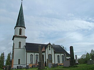
Vennesla is a municipality in Agder county, Norway. It is located in the traditional district of Sørlandet. The administrative centre of the municipality is the village of Vennesla. Other villages in Vennesla include Grovane, Hægeland, Homstean, Mushom, Øvre Eikeland, Øvrebø, Røyknes, and Skarpengland. Vennesla lies about 17 kilometres (11 mi) north of the city of Kristiansand in the Otra river valley.

<span class="mw-page-title-main">Nord-Odal</span> Municipality in Innlandet, Norway

Nord-Odal is a municipality in Innlandet county, Norway. It is located in the traditional district of Odalen. The administrative centre of the municipality is the village of Sand. Other villages in the municipality include Knapper and Mo.

<span class="mw-page-title-main">Lund, Norway</span> Municipality in Rogaland, Norway

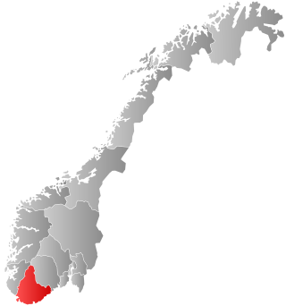
Lund is a municipality in Rogaland county, Norway. It is located in the traditional district of Dalane. The administrative centre of the municipality is the village of Moi. Other villages in Lund include Eik and, Heskestad. European route E39 and the Sørlandet Line both pass through Lund. Moi Station is a railway station in Lund.

<span class="mw-page-title-main">Sveio</span> Municipality in Vestland, Norway

Sveio is a municipality in Vestland county, Norway. Sveio is a border district that is sometimes considered to be located in the traditional district of Haugalandet since it is located on the Haugalandet peninsula, but it is also considered to be in the traditional district of Sunnhordland since it is located in southern Hordaland county. The administrative centre of the municipality is the village of Sveio. Other villages in the municipality include Auklandshamn, Førde, Våga, and Valevåg.

<span class="mw-page-title-main">Hægebostad</span> Municipality in Agder, Norway

Hægebostad is a municipality in Agder county, Norway. It is located in the traditional district of Lister. The administrative centre of the municipality is the village of Tingvatn. Other villages in Hægebostad include Eiken, Haddeland, and Snartemo. The municipality encompasses the northern end of the Lyngdalen valley which follows the river Lygna.

<span class="mw-page-title-main">Kvinesdal</span> Municipality in Agder, Norway

Kvinesdal is a municipality in Agder county, Norway. It is located in the traditional district of Lister. The administrative centre of the municipality is the village of Liknes. Other villages in Kvinesdal include Feda, Fjotland, and Storekvina.

<span class="mw-page-title-main">Lyngdal</span> Municipality in Agder, Norway

is a municipality in Agder county, Norway. It is located in the traditional district of Lister. The administrative centre of the municipality is the town of Alleen. Some of the main villages in Lyngdal include Austad, Byremo, Fleseland, Hæåk, Konsmo, Korshamn, Kvås, Skomrak, Svenevik, and Vivlemo.

<span class="mw-page-title-main">Lindesnes</span> Municipality in Agder, Norway

Lindesnes is a municipality in Agder county, Norway. It is located in the traditional district of Sørlandet. The administrative centre of the municipality is the town of Mandal. Other villages in Lindesnes include Åvik, Høllen, Skofteland, Svenevig, Vigmostad, Heddeland, Bjelland, Breland, Koland, Laudal, Øyslebø, Bykjernen, Skjebstad, Sånum-Lundevik, Skogsfjord-Hesland, Krossen, Harkmark, Skinsnes-Ime, and Tregde-Skjernøy.

<span class="mw-page-title-main">Audnedal</span> Former municipality in Vest-Agder, Norway

Audnedal is a former municipality in the old Vest-Agder county, Norway. It was located in the traditional district of Sørlandet. The administrative centre of the municipality was the village of Konsmo. Other villages in Audnedal include Byremo and Vivlemo. The municipality existed from 1964 until its dissolution in 2020 when Audnedal was merged into the neighboring municipality of Lyngdal in what is now Agder county.

<span class="mw-page-title-main">Marnardal</span> Former municipality in Vest-Agder, Norway

Marnardal is a former municipality in the old Vest-Agder county, Norway. It existed from 1964 until 2020 when it was merged into Lindesnes Municipality in what is now Agder county. It was located in the traditional district of Sørlandet. The administrative centre of the municipality was the village of Heddeland. Other villages in Marnardal include Bjelland, Breland, Koland, Laudal, and Øyslebø.

<span class="mw-page-title-main">Hjartdal</span> Municipality in Telemark, Norway

Hjartdal is a municipality in Telemark county, Norway. It is located in the traditional district of Upper Telemark and Aust-Telemark. The administrative centre of the municipality is the village of Sauland. Other villages in the municipality include Tuddal and Hjartdalsbygda.

<span class="mw-page-title-main">Seljord</span> Municipality in Telemark, Norway

Seljord is a municipality in Telemark county, Norway. It is located in the traditional districts of Upper Telemark and Vest-Telemark. The administrative centre of the municipality is the village of Seljord. Other villages in the municipality include Flatdal and Åmotsdal.

<span class="mw-page-title-main">Vinje</span> Municipality in Telemark, Norway

Vinje is a municipality in Telemark county, Norway. It is located in the traditional district of Vest-Telemark which is part of Øvre Telemark. The administrative centre of the municipality is the village of Åmot. Other villages in the municipality include Arabygdi, Edland, Grunge, Haukeli, Krossen, Møsstrond, Nesland, Øyfjell, Raulandsgrend, and Vinje.

<span class="mw-page-title-main">Notodden</span> Municipality in Telemark, Norway

is a municipality in Telemark county, Norway. It is located in the traditional district of Aust-Telemark. The administrative centre of the municipality is the town of Notodden. Other population centres include the villages of Bolkesjø, Gransherad, Heddal, Hjuksebø, Hjuksevelta, Rudsgrendi, Tinnoset, and Yli.

<span class="mw-page-title-main">Hareid</span> Municipality in Møre og Romsdal, Norway

Hareid is a municipality in Møre og Romsdal county, Norway. It is part of the Sunnmøre region. The administrative centre is the village of Hareid. The other main population centers are Brandal and Hjørungavåg.

<span class="mw-page-title-main">Gjerstad</span> Municipality in Agder, Norway

Gjerstad is a municipality in Agder county, Norway. It is located in the traditional region of Sørlandet, in the southeastern part of the county, along the border with Telemark county. The administrative centre of the municipality is the village of Gjerstad. Other villages in the municipality include Ausland, Eikeland, Fiane, Gryting, Østerholt, Rød, Sundebru, and Vestøl.

<span class="mw-page-title-main">Vegårshei</span> Municipality in Agder, Norway

Vegårshei is a municipality in Agder county, Norway. It is located in the traditional district of Sørlandet. The administrative center is the village of Myra. Other villages in Vegårshei include Mo and Ubergsmoen.

<span class="mw-page-title-main">Åmli</span> Municipality in Agder, Norway

Åmli is a municipality in Agder county, Norway. It is located in the traditional region of Sørlandet. The main population centre and administrative center is the village of Åmli which lies along the river Nidelva. Other villages in Åmli include Askland, Dølemo, Eppeland, Flaten, Hillestad, Homdrom, Lauveik, Nelaug, Øvre Ramse, Skjeggedal, Tveit, Vehus, and Ytre Ramse.

<span class="mw-page-title-main">Iveland</span> Municipality in Agder, Norway

Iveland is a municipality in Agder County, Norway. It is located in the traditional district of Setesdal. The administrative centre of the municipality is the village of Birketveit. Other villages in the municipality include Bakken, Skaiå, and Vatnestrøm.

<span class="mw-page-title-main">Bygland</span> Municipality in Agder, Norway

Bygland is a municipality in Agder county, Norway. It is located in the traditional district of Setesdal. The administrative centre of the municipality is the village of Bygland. Other villages in the municipality include Åraksbø, Austad, Byglandsfjord, Grendi, Langeid, Lauvdal, Litveit, Longerak, Moi, Ose, Sandnes, Skåmedal, and Tveit. The Norwegian National Road 9 runs through the municipality, following the river Otra where most of the population of Bygland lives.

References

  1. "Navn på steder og personer: Innbyggjarnamn" (in Norwegian). Språkrådet.
  2. "Forskrift om målvedtak i kommunar og fylkeskommunar" (in Norwegian). Lovdata.no.
  3. Bolstad, Erik; Thorsnæs, Geir, eds. (26 January 2023). "Kommunenummer". Store norske leksikon (in Norwegian). Kunnskapsforlaget.
  4. Statistisk sentralbyrå. "Table: 06913: Population 1 January and population changes during the calendar year (M)" (in Norwegian).
  5. Statistisk sentralbyrå. "09280: Area of land and fresh water (km²) (M)" (in Norwegian).
  6. Jukvam, Dag (1999). Historisk oversikt over endringer i kommune- og fylkesinndelingen (PDF) (in Norwegian). Statistisk sentralbyrå. ISBN   9788253746845.
  7. Rygh, Oluf (1912). Norske gaardnavne: Lister og Mandals amt (in Norwegian) (9 ed.). Kristiania, Norge: W. C. Fabritius & sønners bogtrikkeri. p. 134.
  8. "Norsk Lovtidende. 2den Afdeling. 1917. Samling af Love, Resolutioner m.m". Norsk Lovtidend (in Norwegian). Oslo, Norway: Grøndahl og Søns Boktrykkeri: 1000. 1917.
  9. Den Nye rettskrivning : regler og ordlister (in Norwegian). Kristiania, Norge: Den Mallingske Boktrykkeri. 1918.
  10. "Civic heraldry of Norway - Norske Kommunevåpen". Heraldry of the World. Retrieved 16 January 2023.
  11. "Aseral, Vest-Agder (Norway)". Flags of the World. Retrieved 16 January 2023.
  12. "Godkjenning av våpen og flagg". Lovdata.no (in Norwegian). Norges kommunal- og arbeidsdepartementet. 17 March 1989. Retrieved 16 January 2023.
  13. "Kommunevåpen". Åseral kommune. Retrieved 12 November 2016.
  14. "Åseral kommune, våpen". Digitalarkivet (in Norwegian). Arkivverket. Retrieved 20 July 2023.
  15. Hansen, Tore; Vabo, Signy Irene, eds. (20 September 2022). "kommunestyre". Store norske leksikon (in Norwegian). Kunnskapsforlaget . Retrieved 14 October 2022.
  16. "Kommunestyrevalg 2023 - Agder". Valgdirektoratet . Retrieved 28 January 2024.
  17. "Kommunestyrevalg 2019 – Agder". Valgdirektoratet . Retrieved 5 December 2020.
  18. 1 2 3 4 "Table: 04813: Members of the local councils, by party/electoral list at the Municipal Council election (M)" (in Norwegian). Statistics Norway.
  19. "Kommunestyrevalg 2011 – Vest-Agder". Valgdirektoratet . Retrieved 5 December 2020.
  20. "Kommunestyrevalget 1995" (PDF) (in Norwegian). Oslo-Kongsvinger: Statistisk sentralbyrå. 1996. Retrieved 5 December 2020.
  21. "Kommunestyrevalget 1991" (PDF) (in Norwegian). Oslo-Kongsvinger: Statistisk sentralbyrå. 1993. Retrieved 5 December 2020.
  22. "Kommunestyrevalget 1987" (PDF) (in Norwegian). Oslo-Kongsvinger: Statistisk sentralbyrå. 1988. Retrieved 5 December 2020.
  23. "Kommunestyrevalget 1983" (PDF) (in Norwegian). Oslo-Kongsvinger: Statistisk sentralbyrå. 1984. Retrieved 5 December 2020.
  24. "Kommunestyrevalget 1979" (PDF) (in Norwegian). Oslo: Statistisk sentralbyrå. 1979. Retrieved 5 December 2020.
  25. "Kommunevalgene 1975" (PDF) (in Norwegian). Oslo: Statistisk sentralbyrå. 1977. Retrieved 5 December 2020.
  26. "Kommunevalgene 1972" (PDF) (in Norwegian). Oslo: Statistisk sentralbyrå. 1973. Retrieved 5 December 2020.
  27. "Kommunevalgene 1967" (PDF) (in Norwegian). Oslo: Statistisk sentralbyrå. 1967. Retrieved 5 December 2020.
  28. "Kommunevalgene 1963" (PDF) (in Norwegian). Oslo: Statistisk sentralbyrå. 1964. Retrieved 5 December 2020.
  29. "Kommunevalgene og Ordførervalgene 1959" (PDF) (in Norwegian). Oslo: Statistisk sentralbyrå. 1960. Retrieved 5 December 2020.
  30. "Kommunevalgene og Ordførervalgene 1955" (PDF) (in Norwegian). Oslo: Statistisk sentralbyrå. 1957. Retrieved 5 December 2020.
  31. "Kommunevalgene og Ordførervalgene 1951" (PDF) (in Norwegian). Oslo: Statistisk sentralbyrå. 1952. Retrieved 5 December 2020.
  32. "Kommunevalgene og Ordførervalgene 1947" (PDF) (in Norwegian). Oslo: Statistisk sentralbyrå. 1948. Retrieved 5 December 2020.
  33. "Kommunevalgene og Ordførervalgene 1945" (PDF) (in Norwegian). Oslo: Statistisk sentralbyrå. 1947. Retrieved 5 December 2020.
  34. "Kommunevalgene og Ordførervalgene 1937" (PDF) (in Norwegian). Oslo: Statistisk sentralbyrå. 1938. Retrieved 5 December 2020.
  35. "eKlima Web Portal". Norwegian Meteorological Institute. Archived from the original on 14 June 2004.