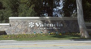
Valencia is a neighborhood in Santa Clarita located within Los Angeles County, California. It is one of the four unincorporated communities that merged to create the city of Santa Clarita in 1987. It is situated in the western part of Santa Clarita, stretching from Lyons Avenue to the south to north of Copper Hill Drive, and from Interstate 5 east to Bouquet and Seco Canyon Roads. Valencia was founded as a master-planned community with the first development, Old Orchard I, built on Lyons Avenue behind Old Orchard Elementary School.

The Santa Susana Mountains are a transverse range of mountains in Southern California, north of the city of Los Angeles, in the United States. The range runs east-west, separating the San Fernando Valley and Simi Valley on its south from the Santa Clara River Valley to the north and the Santa Clarita Valley to the northeast. The Oxnard Plain is to the west of the Santa Susana Mountains.

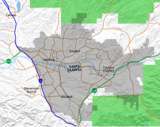
The Santa Clarita Valley (SCV) is part of the upper watershed of the Santa Clara River in Southern California. The valley was part of the 48,612-acre (19,673 ha) Rancho San Francisco Mexican land grant. Located in Los Angeles County, its main population center is the city of Santa Clarita which includes the communities of Canyon Country, Newhall, Saugus, and Valencia. Adjacent unincorporated communities include Castaic, Stevenson Ranch, Val Verde, and the unincorporated parts of Valencia.
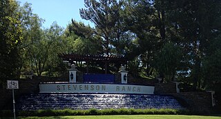
Stevenson Ranch is an unincorporated community in the Santa Clarita Valley of Los Angeles County, California. Stevenson Ranch is set in the foothills of the Santa Susana Mountains and lies west of Interstate 5 and the city of Santa Clarita. Stevenson Ranch encompasses about 6.4 square miles (17 km2). About 1,000 acres (4.0 km2) are set aside as parks, recreation areas, and open space. A master-planned community, it was approved by the county in 1987. The population was 17,557 at the time of the 2010 census. For statistical purposes, the Census Bureau has designated it a census-designated place (CDP).

Newhall is the southernmost and oldest community in the city of Santa Clarita, California. Prior to the 1987 consolidation of Canyon Country, Saugus, Newhall, and Valencia into the city of Santa Clarita, it was an unincorporated area. It was the first permanent town in the Santa Clarita Valley.

Soledad Canyon is a long narrow canyon/valley located in Los Angeles County, California between the cities of Palmdale and Santa Clarita. It is a part of the Santa Clara River Valley, and extends from the top of Soledad Pass to the open plain of the Valley in Valencia. The upstream section of the Santa Clara River runs through it.
Canyon Country is a neighborhood in the eastern part of the city of Santa Clarita, in northwestern Los Angeles County, California, United States. It lies along the Santa Clara River between the Sierra Pelona Mountains and the San Gabriel Mountains. It is the most populous of Santa Clarita's four neighborhoods.

Saugus is a neighborhood in Santa Clarita, California. It was one of four communities that merged in 1987 to create the city of Santa Clarita. Saugus includes the central and north-central portions of the city. It is named after Saugus, Massachusetts, the hometown of Henry Newhall, upon whose land the town was originally built.
A movie ranch is a ranch that is at least partially dedicated for use as a set in the creation and production of motion pictures and television shows. These were developed in the United States in southern California, because of the climate. The first such facilities were all within the 30-mile (48 km) studio zone, often in the foothills of the San Fernando Valley, Santa Clarita Valley, and Simi Valley in the U.S. state of California.
Rustic Canyon is a residential neighborhood and canyon in eastern Pacific Palisades, on the west side of Los Angeles, California. It is along Rustic Creek, in the Santa Monica Mountains.
Santa Clarita is a city in northwestern Los Angeles County, California. With a 2020 census population of 228,673, it is the third-largest city by population in Los Angeles County, and the 17th-largest in the state of California. It is located about 30 miles (48 km) northwest of downtown Los Angeles, and occupies 70.75 square miles (183.2 km2) of land in the Santa Clarita Valley, along the Santa Clara River. It is a notable example of a U.S. edge city, satellite city, or boomburb.
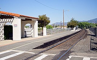
Via Princessa is a Metrolink rail station located in the Canyon Country neighborhood of the city of Santa Clarita, California. It is served by Metrolink's Antelope Valley Line from Los Angeles Union Station to Lancaster.
Anaheim Hills is a planned community encompassing the eastern portions of the city of Anaheim, in Orange County, California.
Valencia is an unincorporated community in northwestern Los Angeles County, California. This area, with major commercial and industrial parks, straddles State Route 126 and the Santa Clara River.

The Sand Fire was a wildfire in 2016 that burned in the Angeles National Forest, east of the Santa Clarita Valley in Los Angeles County, California. The fire, named for the area's Sand Canyon, was fueled by heavy chaparral and brush.

The Creek Fire was a large wildfire that burned in Kagel Canyon and the Angeles National Forest north of Sylmar, a neighborhood in Los Angeles, California, United States, and one of multiple wildfires that broke out across Southern California in December 2017. The Creek Fire has burned 15,619 acres (63 km2) and destroyed 123 structures, including 60 homes, before being contained on January 9, 2018, following heavy rainfall from a winter storm. The fire threatened the communities of Santa Clarita, Glendale, Olive View, Lake View Terrace, Sunland-Tujunga, Shadow Hills, Sylmar, Pacoima, Lopez Canyon, and Kagel Canyon, as well as the Olive View–UCLA Medical Center. During the wildfire, 115,000 residents were forced to evacuate their homes.
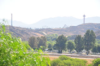
The Rye Fire was a wildfire that burned in Santa Clarita, California, in the United States, and one of multiple wildfires that broke out across Southern California in December 2017. The fire threatened over 5,000 structures, including Six Flags Magic Mountain, threatened the city of Santa Clarita and impacted traffic on Interstate 5. The Rye Fire burned a total of 6,049 acres (24.48 km2), before it was fully contained on December 12. The fire destroyed six buildings, including minor structures located at the Peter J. Pitchess Detention Center.

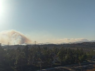
The Tick Fire was a wildfire that burned in Los Angeles County, California. The fire broke out on October 24, 2019, and burned several thousand acres. The fire forced the mass evacuation of 40,000 people from the Santa Clarita Valley.

The Soledad Fire was a wildfire that burned during the 2020 California wildfire season south of Agua Dulce and northeast of Santa Clarita in Los Angeles County, California in the United States. The fire started on July 5, 2020 and caused the complete closure of State Route 14 in both directions throughout the day as the fire grew to 1,498 acres. The fire also at a point threatened over 4,795 structures, although only 9 homes were formally threatened by the direct fireline. The cause of the fire is currently under investigation.


