Winter Hill is a neighborhood in Somerville, Massachusetts, United States. It takes its name from the 120-foot hill that occupies its landscape, the name of which dates back to the 18th century.[1] Winter Hill is located roughly north of Medford Street, west of McGrath Highway, and east of Magoun Square.
Portion of a map from 1775 highlighting the Winter Hill fortification
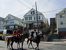
An early map of the area (dated 1637) from the papers of the family of John Winthrop includes some of this neighborhood and the adjacent Ten Hills section.[2] A Map of the Battle of Bunker Hill from 1775 displays Winter Hill to the northwest, with woody and marshy regions beyond.[3] A map by Henry Pelham published in 1777 includes the Winter Hill Fort as part of the "Military Works" in the area.[4] The Winter Hill Fort was described as "extensive" among other American Revolutionary War installations, but little evidence of the structural features remains.[5] A "Plan of the Rebels Works" in the Library of Congress collection offers a glimpse of the layout.[6] This stronghold is also diagrammed in a map credited to John Montrésor indicating that this was a part of Charlestown at the time.[7] The "Midnight Ride" of Paul Revere crossed over Winter Hill, and is re-enacted each year as part of the Patriots' Day festivities in the Boston area.
Patriots' Day re-enactment of Paul Revere's Ride in Winter Hill in 2004
By the 21st century, Winter Hill featured a mix of restored homes and aging triple deckers, replete with china gnomes and bathtub Virgin Marys. Once known as the home base of Irish gangsters Whitey Bulger, James "Buddy" McLean, Howie Winter and the notorious Winter Hill Gang, Winter Hill is now, as much of the rest of Somerville, experiencing gentrification and a resulting rise in property values and rents.[9] Despite these changes, the area continues to hang onto its neighborhood flavor and is home to a large community of Irish and Italian people.
Winter Hill is home to a variety of eateries, Mama Lisa's and Leone's pizza establishments, Sarma, Tipping Cow, the Winter Hill Bakery, and the Winter Hill Brewing Company. A number of new restaurants, cafes, and shops are in the late planning stages. Neighborhood Produce, a small community-based grocery store, serves the neighborhood from a location on Medford St., next to the Winter Hill Community School. The Theater Coop, one of the Boston area's few new repertory live theaters, is located between Foss Park and the local supermarket. Near Winter Hill in East Somerville is a community pottery studio, called Mudflat, and a collective of stained glass artists called Daniel Maher Stained Glass.
Foss Park abuts Interstate 93 at the base of Winter Hill. The park has a large, colorful mural painted behind the public swimming pool, and is home to a wide variety of sporting matches, especially soccer.[10] At one time a portion of the Middlesex Canal was located on land that became this park.
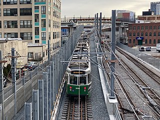
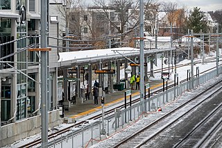
An extension of the Green Line to the Winter Hill area is currently in construction phases, specifically with stations at Medford Street (Gilman Square) and Lowell Street (Magoun Square), though estimated completion has been pushed back, first to December 2021[11] and then to May 2022.[12] As of December 2023, the line is still undergoing extensive work due to the tracks being initially installed using the wrong gauge.[13] Workers are performing track work in the evenings while trolleys run revenue service on the line during the day.[14]
Notes
↑ Henry Pelham, A Plan of Boston in New England with its Environs, Including Milton, Dorchester, Roxbury, Brookline, Cambridge, Medford, Charlestown, Parts of Malden and Chelsea. With the Military Works Constructed in those Places in the Years 1775, and 1776 (London, Published according to Act of Parliament, 1777)
↑ A Plan of Boston in New England with its Environs, including Milton, Dorchester, Roxbury, Brooklin, Cambridge, Medford, Charlestown, Parts of Malden and Chelsea, with the Military Works Constructed in those Places in the Years 1775 and 1776
↑ A draught of the towns of Boston and Charles Town and the circumjacent country shewing the works thrown up by His Majesty's troops, and also those by the rebels, during the campaign: 1775.
Somerville is a city located directly to the northwest of Boston, and north of Cambridge, in Middlesex County, Massachusetts, United States. As of the 2020 United States Census, the city had a total population of 81,045 people. With an area of 4.12 square miles (10.7 km2), the city has a density of 19,671/sq mi (7,595/km2), making it the most densely populated municipality in New England and the 19th most densely populated incorporated municipality in the country. Somerville was established as a town in 1842, when it was separated from Charlestown. In 2006, the city was named the best-run city in Massachusetts by The Boston Globe. In 1972, 2009, and 2015, the city received the All-America City Award. It is home to Tufts University, which has its campus along the Somerville and Medford border.
Charlestown is the oldest neighborhood in Boston, Massachusetts, in the United States. Also called Mishawum by the Massachusett, it is located on a peninsula north of the Charles River, across from downtown Boston, and also adjoins the Mystic River and Boston Harbor waterways. Charlestown was laid out in 1629 by engineer Thomas Graves, one of its earliest settlers, during the reign of Charles I of England. It was originally a separate town and the first capital of the Massachusetts Bay Colony.
The Orange Line is a rapid transit line operated by the Massachusetts Bay Transportation Authority (MBTA) as part of the MBTA subway system. The line runs south on the surface from Oak Grove station in Malden, Massachusetts through Malden and Medford, paralleling the Haverhill Line, then crosses the Mystic River on a bridge into Somerville, then into Charlestown. It passes under the Charles River and runs through Downtown Boston in the Washington Street Tunnel. The line returns to the surface in the South End, then follows the Southwest Corridor southwest in a cut through Roxbury and Jamaica Plain to Forest Hills station.
Davis Square is a major intersection in the northwestern section of Somerville, Massachusetts, where several streets meet: Holland Street, Dover Street, Day Street, Elm Street, Highland Avenue, and College Avenue. The name is often used to refer to the West Somerville neighborhood surrounding the square as well.
Union Square is a neighborhood in the southeastern part of Somerville, Massachusetts, United States. It is centered on Union Square proper, which is located at the intersection of Washington Street, Webster Avenue, and Somerville Avenue.
Ball Square is a neighborhood primarily in Somerville, Massachusetts, but also extending into Medford, at the intersection of Boston Avenue and Broadway, located between Powder House Square and Magoun Square. It is primarily a residential area with a handful of shops and restaurants along Broadway. Located on the edge of the neighborhood surrounding Tufts University, Ball Square contains a mix of businesses serving the student and academic populations as well as those reflecting the more blue-collar neighborhoods to the east.
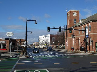
Magoun Square is a neighborhood centered on the intersection of Broadway and Medford Streets on the border of Medford and Somerville, Massachusetts. It is located between the neighborhoods of Ball Square and Winter Hill. It is a mixed-use urban business district, with commercial sites in the square and residential areas surrounding it. Trum Field, a park featuring baseball diamonds and basketball courts, is near Magoun Square, as is the headquarters of the Somerville Department of Public Works. Notable residents include playwright John Shea.
Powder House Square is a neighborhood and landmark rotary in Somerville, Massachusetts, United States. It is also known locally as Powder House Circle. It is the 6-way intersection of College Avenue, Broadway, Warner Street, and Powder House Boulevard. Powder House Square stands at the southern tip of Tufts University's main Somerville/Medford campus, and borders the northern edge of Nathan Tufts Park. The square takes its name from the 18th century Powder House which overlooks the rotary from Nathan Tufts Park.
Charlestown Heights later known as Ensign John J. Doherty Park, is an urban park in Charlestown, a neighborhood of Boston, Massachusetts. It is one of five small urban parks designed by Frederick Law Olmsted for the city. These parks were designed to provide greenspaces in densely populated neighborhoods. Charlestown Heights was laid out on the North side of Bunker Hill, sloping down the hill from Bunker Hill Street to Medford Street, between St. Martin Street and North Mead Street.
The Green Line Extension (GLX) was a construction project to extend the Massachusetts Bay Transportation Authority (MBTA) Green Line light rail system northwest into Somerville and Medford, two inner suburbs of Boston, Massachusetts. The project opened in two phases in 2022 at a total cost of $2.28 billion. Total ridership on the 4.3-mile (6.9 km) extension is estimated to reach 45,000 one-way trips per day in 2030.
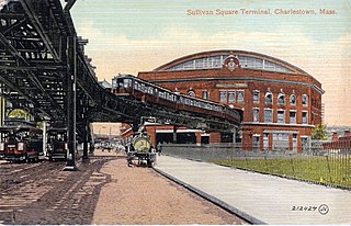
Sullivan Square is a traffic circle located at the north end of the Charlestown neighborhood of Boston, Massachusetts. It is named after James Sullivan, an early 19th-century Governor of Massachusetts. Sullivan Square station on the MBTA Orange Line is located just west of the square.
Medford/Tufts station is a light rail station on the Massachusetts Bay Transportation Authority (MBTA) Green Line located off Boston Avenue near College Avenue in Medford, Massachusetts, adjacent to Tufts University. The accessible station has a single island platform serving the two tracks of the Medford Branch. It opened on December 12, 2022, as part of the Green Line Extension (GLX), which added two northern branches to the Green Line, and is the northern terminus of the E branch.
Ball Square station is a light rail station on the Massachusetts Bay Transportation Authority (MBTA) Green Line located at Ball Square in Somerville and Medford, Massachusetts. The accessible station has a single island platform serving the two tracks of the Medford Branch. It opened on December 12, 2022, as part of the Green Line Extension (GLX), which added two northern branches to the Green Line, and is served by the E branch.
Magoun Square station is a light rail station on the Massachusetts Bay Transportation Authority (MBTA) Green Line located at Lowell Street south of Magoun Square in Somerville, Massachusetts. The accessible station has a single island platform serving the two tracks of the Medford Branch. It opened on December 12, 2022, as part of the Green Line Extension (GLX), which added two northern branches to the Green Line, and is served by the E branch.
Gilman Square station is a light rail station on the Massachusetts Bay Transportation Authority (MBTA) Green Line located at Gilman Square in Somerville, Massachusetts. The accessible station has a single island platform serving the two tracks of the Medford Branch. It opened on December 12, 2022, as part of the Green Line Extension (GLX), which added two northern branches to the Green Line, and is served by the E branch.
East Somerville station is a light rail station on the Massachusetts Bay Transportation Authority (MBTA) Green Line located in southeastern Somerville, Massachusetts. The accessible station has a single island platform serving the two tracks of the Medford Branch. It opened on December 12, 2022, as part of the Green Line Extension (GLX), which added two northern branches to the Green Line, and is served by the E branch.
Union Square station is a light rail station on the Massachusetts Bay Transportation Authority (MBTA) Green Line located in the Union Square neighborhood of southeastern Somerville, Massachusetts. The accessible terminal station has a single island platform serving the two tracks of the Union Square Branch, which parallels the Fitchburg Line. It opened on March 21, 2022, as part of the Green Line Extension (GLX), which added two northern branches to the Green Line.
East Somerville is a neighborhood in the eastern part of the city of Somerville, Massachusetts. The community stretches east along Broadway from Massachusetts Route 28 to Sullivan Square and Interstate 93 on the city line with the Boston neighborhood of Charlestown.
Fort Hill is a 0.4 square mile neighborhood and historic district of Roxbury, in Boston, Massachusetts. The approximate boundaries of Fort Hill are Malcolm X Boulevard on the north, Washington Street on the southeast, and Columbus Avenue on the southwest.
The Massachusetts Bay Transportation Authority operates subway, bus, commuter rail, and ferry service in the Greater Boston region. Boston has some of the highest rates of non-motorized commuting in the United States, including high bicycle usage. The MBTA offers certain provisions for riders wishing to make part of their trips by bicycle. The agency allows bicycles to be carried on all fixed-route services except the Green Line and the Ashmont-Mattapan High Speed Line light rail lines, although they are restricted on the commuter rail and heavy rail subway services at peak hours. Bicycle storage areas are offered at many stations, with "Pedal and Park" locking bicycle cages at certain high-usage stations.
This page is based on this Wikipedia article Text is available under the CC BY-SA 4.0 license; additional terms may apply. Images, videos and audio are available under their respective licenses.