Agenda, Wisconsin

Last updated

Agenda, Wisconsin
WIMap-doton-Agenda.png
Location of Agenda, Wisconsin
Coordinates: 46°4′46″N90°22′55″W / 46.07944°N 90.38194°W / 46.07944; -90.38194
Country Flag of the United States.svg  United States
State Flag of Wisconsin.svg  Wisconsin
County Ashland
Area
  Total89.5 sq mi (231.9 km2)
  Land88.8 sq mi (230.0 km2)
  Water0.7 sq mi (1.9 km2)
Elevation
[1]
1,608 ft (490 m)
Population
 (2010)
  Total422
  Density5/sq mi (1.8/km2)
Time zone UTC-6 (Central (CST))
  Summer (DST) UTC-5 (CDT)
Area codes 715 & 534
FIPS code 55-00550 [2]
GNIS feature ID1582660 [1]

Agenda is a town in Ashland County in the U.S. state of Wisconsin. The population was 422 at the 2010 census. [3] The unincorporated communities of Holts Landing and Petes Landing are located in the town.

Contents

History

The name for the town was derived from discussion items at a meeting for the formation of the town, called an “agenda”. [4]

Geography

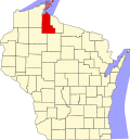
Agenda occupies the southeast corner of Ashland County and is bordered by Iron County to the east and north and by Price County to the south. The towns of Chippewa and Peeksville and the village of Butternut are to the west. The Flambeau River, a major tributary of the Chippewa River, flows through the southeast portion of the town.

According to the United States Census Bureau, the town of Agenda has a total area of 89.5 square miles (231.9 km2), of which 88.8 square miles (230.0 km2) is land and 0.73 square miles (1.9 km2), or 0.83%, is water. [3]

Demographics

As of the census [2] of 2000, there were 513 people, 208 households, and 149 families residing in the town. The population density was 5.8 people per square mile (2.2/km2). There were 328 housing units at an average density of 3.7 per square mile (1.4/km2). The racial makeup of the town was 98.83% White, 0.19% African American, 0.19% Native American, and 0.78% from two or more races.

There were 208 households, out of which 27.9% had children under the age of 18 living with them, 64.4% were married couples living together, 5.3% had a female householder with no husband present, and 27.9% were non-families. 24.0% of all households were made up of individuals, and 12.5% had someone living alone who was 65 years of age or older. The average household size was 2.47 and the average family size was 2.93.

In the town, the population was spread out, with 21.4% under the age of 18, 7.2% from 18 to 24, 27.1% from 25 to 44, 26.9% from 45 to 64, and 17.3% who were 65 years of age or older. The median age was 42 years. For every 100 females, there were 116.5 males. For every 100 females age 18 and over, there were 107.7 males.

The median income for a household in the town was $37,857, and the median income for a family was $46,111. Males had a median income of $37,500 versus $18,750 for females. The per capita income for the town was $17,578. About 2.1% of families and 4.1% of the population were below the poverty line, including 4.2% of those under age 18 and 4.4% of those age 65 or over.

Related Research Articles

<span class="mw-page-title-main">Chippewa, Wisconsin</span> Town in Wisconsin, United States

Chippewa is a town in Ashland County in the U.S. state of Wisconsin. The population was 374 at the 2010 census.

<span class="mw-page-title-main">Gingles, Wisconsin</span> Town in Wisconsin, United States

Gingles is a town in Ashland County in the U.S. state of Wisconsin. The population was 778 at the 2010 census. The unincorporated community of White River is located in the town.

<span class="mw-page-title-main">Gordon, Ashland County, Wisconsin</span> Town in Wisconsin, United States

Gordon is a town in Ashland County in the U.S. state of Wisconsin. The population was 283 at the 2010 census. The unincorporated communities of Clam Lake and Morse are located in the town.

<span class="mw-page-title-main">Jacobs, Wisconsin</span> Town in Wisconsin, United States

Jacobs is a town in Ashland County in the U.S. state of Wisconsin. The population was 722 at the 2010 census. The unincorporated community of Glidden is located within the town.

<span class="mw-page-title-main">Marengo, Wisconsin</span> Town in Wisconsin, United States

Marengo is a town in Ashland County in the U.S. state of Wisconsin. The population was 390 at the 2010 census.

<span class="mw-page-title-main">Morse, Wisconsin</span> Town in Wisconsin, United States

Morse is a town in Ashland County in the U.S. state of Wisconsin. The population was 493 at the 2010 census. The unincorporated communities of Ballou, Cayuga, Foster Junction, and Penokee are located in the town.

<span class="mw-page-title-main">Odanah, Wisconsin</span> Census-designated place in Wisconsin, United States

Odanah is an unincorporated community and census-designated place (CDP) in Ashland County, Wisconsin, in the town of Sanborn, United States, on the banks of the Bad River. The population was 47 at the 2020 census.

<span class="mw-page-title-main">Peeksville, Wisconsin</span> Town in Wisconsin, United States

Peeksville is a town in Ashland County in the U.S. state of Wisconsin. The population was 141 at the 2010 census.

<span class="mw-page-title-main">Sanborn, Wisconsin</span> Town in Wisconsin, United States

Sanborn is a town in Ashland County in the U.S. state of Wisconsin. The population was 1,331 at the 2010 census. The unincorporated communities of Bayfront, Birch, Birch Hill, Diaperville, Franks Field, New Odanah, Odanah, and Sedgwick are located in the town. Long Island, one of the Apostle Islands, is also a part of the town. The entire town is part of the Bad River Reservation of the Bad River Band of the Lake Superior Tribe of Chippewa Indians.

<span class="mw-page-title-main">Shanagolden, Wisconsin</span> Town in Wisconsin, United States

Shanagolden is a town in Ashland County in the U.S. state of Wisconsin. The population was 125 at the 2010 census. The unincorporated community of Shanagolden is located in the town.

<span class="mw-page-title-main">White River, Wisconsin</span> Town in Wisconsin, United States

White River is a town in Ashland County, Wisconsin, United States. The population was 921 at the 2010 census. The census-designated place of Marengo and unincorporated communities of Sanborn and part of Jolmaville are located in the town.

<span class="mw-page-title-main">Dovre, Wisconsin</span> Town in Wisconsin, United States

Dovre is a town in Barron County in the U.S. state of Wisconsin. The population was 849 at the 2010 census.

<span class="mw-page-title-main">Eileen, Wisconsin</span> Town in Wisconsin, United States

Eileen is a town in Bayfield County, Wisconsin, United States. The population was 681 at the 2010 census. The unincorporated community of Ashland Junction is located in the town.

<span class="mw-page-title-main">Maxville, Wisconsin</span> Town in Wisconsin, United States

Maxville is a town in Buffalo County in the U.S. state of Wisconsin. The population was 309 at the 2010 census. The ghost town of Savoy was located in the town.

<span class="mw-page-title-main">Auburn, Chippewa County, Wisconsin</span> Town in Wisconsin, United States

Auburn is a town in Chippewa County in the U.S. state of Wisconsin. The population was 697 at the 2010 census, up from 580 at the 2000 census.

<span class="mw-page-title-main">Birch Creek, Wisconsin</span> Town in Wisconsin, United States

Birch Creek is a town in Chippewa County in the U.S. state of Wisconsin. The population was 495 at the 2020 census.

<span class="mw-page-title-main">Cooks Valley, Wisconsin</span> Town in Wisconsin, United States

Cooks Valley is a town in Chippewa County in the U.S. state of Wisconsin. The population was 805 at the 2010 census, up from 632 at the 2000 census. The town was named after Jacob Cook, who purchased property in the valley in the summer of 1858. A post office was established in 1870 with William Miller as the first postmaster.

<span class="mw-page-title-main">Tilden, Wisconsin</span> Town in Wisconsin, United States

The Town of Tilden is located in Chippewa County in the U.S. state of Wisconsin. The population was 1,485 at the 2010 census, up from 1,185 at the 2000 census.

Ashland is a town in Ashland County, Wisconsin. The population was 594 at the time of the 2010 census. The city of Ashland, population 7,908, is located about 15 miles (24 km) northwest of the town. The unincorporated communities of High Bridge, Minersville, North York, and part of Jolmaville are located in the town.

Nelson is a town in Buffalo County in the U.S. state of Wisconsin. The population was 571 at the 2010 census. The village of Nelson is located within the town. The unincorporated community of Misha Mokwa and railroad junction Trevino are located in the town. The unincorporated community of Urne is located partially in the town.

References

  1. 1 2 "US Board on Geographic Names". United States Geological Survey. October 25, 2007. Retrieved January 31, 2008.
  2. 1 2 "U.S. Census website". United States Census Bureau . Retrieved January 31, 2008.
  3. 1 2 "Geographic Identifiers: 2010 Demographic Profile Data (G001): Agenda town, Ashland County, Wisconsin". U.S. Census Bureau, American Factfinder. Archived from the original on February 12, 2020. Retrieved September 6, 2013.
  4. Gard, Robert (2015). The Romance of Wisconsin Place Names (2nd ed.). Madison, WI: Wisconsin Historical Society Press. p. 6. ISBN   978-0-87020-707-5.