
Lava Beds National Monument is located in northeastern California, in Siskiyou and Modoc counties. The monument lies on the northeastern flank of Medicine Lake Volcano, which is the largest volcano by area in the Cascade Range.

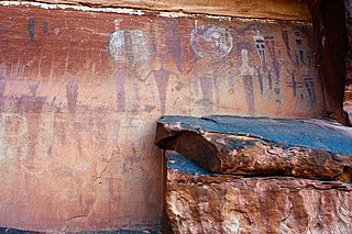
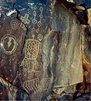
A petroglyph is an image created by removing part of a rock surface by incising, picking, carving, or abrading, as a form of rock art. Outside North America, scholars often use terms such as "carving", "engraving", or other descriptions of the technique to refer to such images. Petroglyphs, estimated to be 20,000 years old are classified as protected monuments and have been added to the tentative list of UNESCO's World Heritage Sites. Petroglyphs are found worldwide, and are often associated with prehistoric peoples. The word comes from the Greek prefix petro-, from πέτρα petra meaning "stone", and γλύφω glýphō meaning "carve", and was originally coined in French as pétroglyphe.

In archaeology, rock arts are human-made markings placed on natural surfaces, typically vertical stone surfaces. A high proportion of surviving historic and prehistoric rock art is found in caves or partly enclosed rock shelters; this type also may be called cave art or parietal art. A global phenomenon, rock art is found in many culturally diverse regions of the world. It has been produced in many contexts throughout human history. In terms of technique, the four main groups are:

The El Paso Mountains Wilderness was created in 1994 and now has a total of 23,780 acres (96.2 km2). All of the wilderness is in the northern Mojave Desert in eastern Kern County, California and is managed by the Bureau of Land Management. It is located south of Ridgecrest, California.

The Palatki Heritage Site is an archaeological site and park located in the Coconino National Forest, near Sedona, in Arizona, United States at approximately 34°54′56″N 111°54′08″W. In the Hopi language Palatki means 'red house'.

Casa Malpaís is an archaeological site of the Ancestral Puebloans located near the town of Springerville, Arizona. The site is a nationally recognized archaeological site and was declared a National Historic Landmark in 1964.

The Caguana Ceremonial Ball Courts Site is an archaeological site located in Caguana, Utuado in Puerto Rico, considered to be one of the largest and most important Pre-Columbian sites in the West Indies. The site is known for its well-preserved ceremonial ball courts and petroglyph-carved monoliths. Studies estimate the in-situ courts to be over 700 years old, built by the Taíno around 1270 AD.

The mountains in the McCullough Range lie mostly above the city of Henderson in the U.S. state of Nevada. The range has two distinct areas with the northern portion being primarily volcanic in origin, while the southern part of the range is primarily composed of metamorphic rock.

Tule Springs is one of the larger urban retreats in Las Vegas, Nevada, and the Las Vegas Valley. It is a significant desert ecosystem consisting of a series of small lakes that formed an oasis in this area of the Mojave Desert. Both the springs and the ranch are located within the Floyd Lamb Park at Tule Springs which is operated by the City of Las Vegas.

Coso Rock Art District is a rock art site containing over 100,000 Petroglyphs by Paleo-Indians and/or Native Americans. The district is located near the towns of China Lake and Ridgecrest, California. Big and Little Petroglyph Canyons were declared a National Historic Landmark in 1964. In 2001, they were incorporated into this larger National Historic Landmark District. There are several other distinct canyons in the Coso Rock Art District besides the Big and Little Petroglyph Canyons. Also known as Little Petroglyph Canyon and Sand Tanks, Renegade Canyon is but one of several major canyons in the Coso Range, each hosting thousands of petroglyphs. The majority of the Coso Range images fall into one of six categories: bighorn sheep, entopic images, anthropomorphic or human-like figures, other animals, weapons & tools, and "medicine bag" images. Scholars have proposed a few potential interpretations of this rock art. The most prevalent of these interpretations is that they could have been used for rituals associated with hunting.
Barrier Canyon Style (BCS) describes a distinctive style of rock art which appears mostly in Utah, with the largest concentration of sites in and around the San Rafael Swell and Canyonlands National Park, but the full range extends into much of the state and western Colorado. The term was first applied by Polly Schaafsma to describe a handful of similar sites known at the time, including several along Barrier Creek in Horseshoe Canyon. Barrier Canyon Style rock art panels are mostly pictographs (painted) but there are also several petroglyphs (pecked) in the style. These panels are believed to have been created during the archaic period and are estimated to be somewhere in the range of 1500 to 4000 years old, possibly older -- clay figurines of a similar style found in Cowboy Cave have been dated to over 7000 years old.
Fort Rock–Christmas Lake Valley is a basin of a former inland sea that existed in that region from Pliocene through late Pleistocene time.
American Indian Rock Art in Minnesota MPS is a Multiple Property Submission (MPS) of the eligibility of many rock art properties for listing on the National Register of Historic Places. The listing is to protect and preserve Native American petroglyphs, pictographs and petroform rock art sites in the present day U.S. state of Minnesota.
The Courthouse Wash Pictographs are a series of large pictographs created over a long period of time, located on a sheltered sandstone wall at the mouth of Courthouse Wash, Arches National Park in Grand County, Utah, United States, just north of Moab, that is listed on the National Register of Historic Places (NRHP).
The Black Mountain Rock Art District is an archaeological district located in the Mojave Desert northwest of Barstow, San Bernardino County, California. The district includes a large collection of Native American rock art, including over 12,000 petroglyphs. The largest group of petroglyphs, which includes over 1,000 of the designs, is in Inscription Canyon. The more complex designs include humanoid figures, shields, masks, baskets, deer, bighorn sheep, and other plants and animals. Other petroglyphs represent patterns such as circles, lines, and zigzags. Native Americans made petroglyphs in the area due to its abundance of easily marked lava rock and hard quartz for making etching tools.

The East Lake Abert Archeological District is an area in Lake County, Oregon, United States, that features numerous prehistoric camp sites and petroglyphs. It is located along the eastern shore of Lake Abert on land administered by the Bureau of Land Management and the Oregon Department of Transportation. The site includes stone-walled house pits and prehistoric rock art made by ancient Native Americans who occupied the site for approximately 11,000 years. Because of its unique archaeological and cultural significance, the East Lake Abert Archaeological District was listed on the National Register of Historic Places in 1978.
Big Gyp Cave Pictograph site (14CM305) in Comanche County, Kansas, is an archeological site with pictographs in a cave. It was listed on the National Register of Historic Places in 1978.

Cima volcanic field is a volcanic field in San Bernardino County, California, close to the border with Nevada. The volcanic field covers a surface area of 600 km2 (230 sq mi) within the Mojave National Preserve west of the Cima Dome and consists of about 40 volcanic cones with about 60 lava flows. The volcanic cones range from simple cones over multi-cratered mountains to eroded hills, and lava flows are up to 9.1 km (5.7 mi) long. At least one lava tube exists in the field and can be visited.
Cueva La Mora is the name of a cave and archaeological site located in or near Comerío, Puerto Rico. The cave was added to the United States National Register of Historic Places on March 10, 1983, and to the Puerto Rico Register of Historic Sites and Zones in 2000 due to its importance in yielding information about the Pre-Columbian history of Puerto Rico and the Caribbean.

