Albert Bridge, Brisbane

Last updated

Albert Bridge
Albert Bridge, Brisbane 4.jpg
Coordinates 27°30′20″S152°58′25″E / 27.5056°S 152.9737°E / -27.5056; 152.9737
CarriesRailway
Crosses Brisbane River
Locale Brisbane, Queensland, Australia
Official nameAlbert Bridge
Characteristics
DesignSteel Truss bridge
Total length208 metres (682 ft)
Longest spantwo spans each 103.7 metres (340 ft)
History
Opened1895;129 years ago (1895)
Location
Albert Bridge, Brisbane
Australia Queensland location map.svg
Red pog.svg
Location of Albert Bridge, Brisbane in Queensland
LocationBrisbane River between Indooroopilly and Chelmer, Indooroopilly, City of Brisbane, Queensland, Australia
Coordinates 27°30′21″S152°58′26″E / 27.5059°S 152.9739°E / -27.5059; 152.9739
Design period1870s–1890s (late 19th century)
Built1894–1895
Architect Henry Charles Stanley
Official nameAlbert Bridge
Typestate heritage (built)
Designated21 October 1992
Reference no.600232
Significant period1890s (fabric)
Significant componentspier/s (bridge), abutments – railway bridge
BuildersJohn McCormick & Son
Original Albert Bridge, looking south to Chelmer OriginalAlbertBridge.jpg
Original Albert Bridge, looking south to Chelmer
Original Albert Bridge (destroyed in the 1893 Brisbane flood) 1893 Brisbane flood Indpilly Rw Br.jpg
Original Albert Bridge (destroyed in the 1893 Brisbane flood)

Albert Bridge is a heritage-listed railway bridge of steel truss design crossing the Brisbane River between Indooroopilly and Chelmer in the City of Brisbane, Queensland, Australia. It was designed by Henry Charles Stanley and built from 1894 to 1895 by John McCormick & Son as a replacement for an earlier bridge lost to flooding in 1893. Both bridges were named in honour of the Prince of Wales, Prince Albert. It was added to the Queensland Heritage Register on 21 October 1992. [1]

Contents

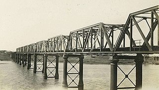
The Albert Bridge links Indooroopilly and Chelmer railway station. The structure consists of two steel spans supported by masonry abutments and a central concrete pier that is encased in an iron caisson. [2] A footway was provided on the upstream side.

History

The first Albert Bridge on the site was completed in june 1876 [3] and enabled the Main Line railway from Grandchester to Ipswich to be extended to reach Brisbane itself. [4] In the early days of settlement, the Brisbane River at Indooroopilly provided an obstacle to the construction of a railway between Brisbane and the mining centre of Ipswich. At this time, a river boat service linked the two centres. The completion of the first Albert Bridge enabled the Ipswich railway line to open in 1875. The bridge facilitated the mass transportation of goods between Ipswich and Brisbane, which previously was only possible through shipping. [5] The first bridge was destroyed in the 1893 flood. [6] [7] In the meantime, ferries were used to transport people and goods across the busy river. This, however, led to the capsize of the ferry Pearl disaster in 1896 with the loss of more than 40 lives.

The second and current Albert Bridge was built in 1895. [6] It was designed by Henry Charles Stanley, Queensland's Chief Engineer of Railways from 1891 to 1901 and is considered his major work. [2] He designed a "hogsback" steel truss bridge on masonry piers. In designing the bridge as two long spans with one central pier, he tried to minimise the obstruction to flood waters created by multiple piers, which had been the downfall of the first bridge. [1]

Innovations in the design included the attachment of cross girders, protection against derailment, provision against strong wind gusts, and provision for free expansion under varying temperatures. The working drawings and specification were prepared by FL Keir of the Chief Engineer's office, and were completed by mid-1893. Keir was also the resident engineer on the site. [1]

In August 1893 the contract was let to Brisbane contractors John McCormick & Son, with a price of £ 66,061. McCormick & Son also later won the contract for the ironwork on the second permanent Victoria Bridge, 1896–97. Expiry date for the Albert Bridge contract was set at 14 December 1894, but it was not opened to traffic until August 1895. A Scottish coal strike held up delivery of the rolled steel for eight months, and removal of the river bedrock for the central pier alone took four months. [1]

A condition of the construction contract was that as much of the work as possible be done in Queensland. Messrs McCormick erected a workshop adjacent to the site at Indooroopilly, and imported machinery necessary for constructing the superstructure and the caisson for the central pier. Up to 240 persons were employed on site at any one time, and quarry workers provided freestone from Pearson's quarries at Helidon, the bluestone in the concrete from Jenkin's Bundamba quarry, and the granite for the bedstones and cutwater quoins from Mount Crosby. In 1895 the bridge was the largest in Australia of local manufacture. [1]

The most difficult aspect of the work was the construction of the central pier and its foundation caisson. The latter weighed about 230 long tons (230 t), rested 81 feet (25 m) below high water mark, and was sunk 2 feet (0.61 m) into the rock. The riverbed sand and gravel could be dredged, but divers extracted the rock manually. [1]

The southern span was erected above what remained of the former bridge, and was extended to the centre pier. The old pylons were then removed. [1]

The northern truss was floated into position. The shore end rested on two trolleys, and when the tide was at its highest, specially constructed staging on an old barque took the weight of the other end of the truss from temporary piles. Winches were then used to pull the hulk across the river toward the centre pier, to which the truss was attached. [1]

The cores of the earlier bridge abutments were widened and heightened to take the new superstructure. Parapets were constructed after the trusses had been fixed in place, and were completed in November 1895. [1]

When opened the bridge also catered for pedestrian traffic, [1] until the construction of the nearby Walter Taylor Bridge in 1937. [8]

The Albert Bridge remains one of Australia's largest truss bridges. At the time of its completion, as a metal truss bridge it was second only to the first Hawkesbury rail bridge (1889) in span length. The Albert Bridge is still Australia's third longest span metal truss bridge, after Brisbane's Story Bridge (1940) (Story Bridge) and the second Hawkesbury rail bridge (1945). [1]

The bridge was integral to the southwest railway system linking Brisbane with Ipswich, the Darling Downs, and southeast Queensland. With increased traffic it was supplemented with an adjacent upstream rail bridge in 1957, which together remained the only Brisbane River rail crossing prior to construction of the Merivale Bridge in 1978. [1]

The Albert Bridge currently handles only passenger traffic. [1]

A second unnamed railway bridge is located between the Albert Bridge and the Walter Taylor Bridge. This second crossing was constructed in 1957 as part of the quadruplication of the Ipswich railway line. [8]


Description

The Albert Bridge spans the Brisbane River from Indooroopilly to Chelmer, at the junction of the Chelmer and Indooroopilly reaches. [1]

It is a fully riveted structure consisting of two arched "hogsback" mild steel trusses supported on stone abutments either side, and on a central concrete pier. This pier is encased in an elliptical wrought- iron caisson to low water level, then built up with masonry to the truss bearings. [1]

Each truss is 103.7 metres (340 ft) long, 12.6 metres (41 ft) high in the middle, 8.2 metres (27 ft) wide, and weighs approximately 606 metric tons (596 long tons; 668 short tons). Their design employs a double-intersection web system of diagonal members, based on the Linville system developed in the United States in the 1860s. They are strengthened by horizontal wind bracing at roadway level, and by elaborate overhead cross bracing. [1]

The double railroad is carried by four longitudinal steel trough girders, with the sides of the troughs acting as guards against derailment. These are supported by massive cross-girders riveted to the underneath of the vertical struts and lower booms of the main trusses, at 5.2 metres (17 ft) intervals. The decking consists of ironbark longitudinals bedded on bitumen and sand, and bolted to steel tee bars which connect the trough girders transversely. [1]

A cantilevered wrought iron footway is carried on the upstream side of the bridge. [1]

Heritage listing

The Albert Bridge was registered on the (now defunct) Register of the National Estate in 1988. It was listed on the Queensland Heritage Register on 21 October 1992 having satisfied the following criteria. [1]

The place is important in demonstrating the evolution or pattern of Queensland's history.

Albert Bridge at Indooroopilly is significant as an early, large span metal truss bridge in Australia, and remains the country's third longest span metal truss bridge. At the time of construction, Albert Bridge was the largest bridge in Australia to be manufactured locally. Albert Bridge is significant for its contribution to the railway system linking the capital with southern and western Queensland, remaining for over six decades part of the only railway link across the Brisbane River. [1]

The place is important in demonstrating the principal characteristics of a particular class of cultural places.

The bridge is highly intact, and provides important physical evidence of late 19th century railway bridge design and construction in Australia. [1]

The place is important because of its aesthetic significance.

The bridge is important also for its landmark quality and aesthetic contribution to the riverscape along the Indooroopilly reach of the Brisbane River. [1]

The place is important in demonstrating a high degree of creative or technical achievement at a particular period.

It is important for its innovations in design and implementation, and remains a major example of the design skills of engineer HC Stanley, and of the work of Brisbane contractors John McCormick & Son. [1]

The place has a special association with the life or work of a particular person, group or organisation of importance in Queensland's history.

It is important for its innovations in design and implementation, and remains a major example of the design skills of engineer HC Stanley, and of the work of Brisbane contractors John McCormick & Son. [1]

See also

Related Research Articles

<span class="mw-page-title-main">William Jolly Bridge</span> Bridge in Queensland, Australia

The William Jolly Bridge is a heritage-listed road bridge over the Brisbane River between North Quay in the Brisbane central business district and Grey Street in South Brisbane, within City of Brisbane, Queensland, Australia. It was designed by Harding Frew and built from 1928 to 1932 by MR Hornibrook.

<span class="mw-page-title-main">Walter Taylor Bridge</span> Heritage-listed bridge in Brisbane, Australia

The Walter Taylor Bridge is a heritage-listed suspension bridge crossing the Brisbane River between Indooroopilly and Chelmer in Brisbane, Queensland, Australia. It is shared by motor traffic and pedestrians and is the only habitable bridge in the Southern Hemisphere. It was originally known as the Indooroopilly Toll Bridge.

<span class="mw-page-title-main">Graceville railway station</span> Historic site in Queensland, Australia

Graceville railway station is a heritage-listed railway station at 110 Long Street, Graceville, City of Brisbane, Queensland, Australia. It is on the Main line, serving the suburb of Graceville. It was designed by John Sidney Egan and Jan Kral and built from 1958 to 1959 by Railways Department. It was added to the Queensland Heritage Register on 12 June 2009.

<span class="mw-page-title-main">Chelmer, Queensland</span> Suburb of Brisbane, Queensland, Australia

Chelmer is a south-western suburb in the City of Brisbane, Queensland, Australia. In the 2016 census, Chelmer had a population of 2,998 people.

<span class="mw-page-title-main">Hawkesbury River railway bridge</span> Railway bridge in New South Wales, Australia

The Hawkesbury River railway bridge is a heritage-listed railway bridge in New South Wales, Australia that carries the Main North railway line across the Hawkesbury River. The bridge crosses between Brooklyn on the northern outskirts of Sydney and Cogra Bay in the Central Coast region. The railway bridge was to be the last link in a railway network that linked the state capitals Adelaide, Melbourne, Sydney and Brisbane and was a major engineering feat at the time. The original railway bridge was built in 1889 and replaced by the current bridge in 1946. The 1946 bridge was added to the New South Wales State Heritage Register on 2 April 1999.

<span class="mw-page-title-main">Indooroopilly Railway Bridge</span> Bridge in Queensland, Australia

The Indooroopilly Railway Bridge is a railway bridge of steel truss design which crosses the Brisbane River, Queensland, Australia. The Indooroopilly Railway Bridge links Indooroopilly and Chelmer stations, and has two long spans with one central pier. It was built just upstream and parallel to the Albert Bridge as part of the quadruplication of the Ipswich Line between 1955 and 1957.

<span class="mw-page-title-main">Dickabram Bridge</span> Heritage listed road and rail bridge in Queensland, Australia

Dickabram Bridge is a heritage-listed road-and-rail bridge over the Mary River between Miva and Theebine, both in the Gympie Region, Queensland, Australia. It was the major bridge on the Kingaroy railway line. It was designed by Henry Charles Stanley and built from 1885 to 1886 by Messrs Michael McDermott, Owens & Co. It is also known as Mary River Bridge (Miva). The bridge was registered on the former Register of the National Estate in 1988.

<span class="mw-page-title-main">Peats Ferry Bridge</span> Bridge in New South Wales, Australia

The Peats Ferry Bridge is a steel truss bridge that carries the Pacific Highway (B83) across the Hawkesbury River, between Kangaroo Point and Mooney Mooney Point, located 40 kilometres (25 mi) north of Sydney in New South Wales, Australia. The bridge carries the Hornsby to Kariong section of highway, while the adjacent Brooklyn Bridge carries the Pacific Motorway (M1).

<span class="mw-page-title-main">Main Line railway, Queensland</span> Railway line in Queensland, Australia

The Main Line is a railway line in South East Queensland, Australia. It was opened in a series of sections between 1865 and 1867. It commences at Roma St Station in Brisbane and extends west 161 km to Toowoomba. It is the first narrow gauge main line constructed in the world. The section of the line from the end of Murphys Creek railway station to the Ruthven Street overbridge, Harlaxton is listed on the Queensland Heritage Register. The Murphys Creek Railway Complex, the Lockyer Creek Railway Bridge (Lockyer), the Lockyer Creek Railway Bridge and Swansons Rail Bridge are also heritage listed.

<span class="mw-page-title-main">Sadliers Crossing Railway Bridge</span> Historic site in Queensland, Australia

Sadliers Crossing Railway Bridge is a heritage-listed railway bridge at over Bremer River between Tallon Street, Sadliers Crossing and Dixon Street, Wulkuraka, Queensland, Australia on the Main Line (this section is now the Ipswich and Rosewood railway line. It was added to the Queensland Heritage Register on 13 November 2008.

<span class="mw-page-title-main">Bremer River Rail Bridge</span> Railway bridge in City of Ipswich Queensland in Australia

Bremer River Rail Bridge is a heritage-listed railway bridge at off Bremer Street, North Ipswich, City of Ipswich, Queensland, Australia. It was built from 1865 to 1915. It was added to the Queensland Heritage Register on 11 December 2006.

<span class="mw-page-title-main">Lockyer Creek Railway Bridge (Clarendon)</span> Historic site in Queensland, Australia

Lockyer Creek Railway Bridge is a heritage-listed railway bridge on the Brisbane Valley railway line over Lockyer Creek at Clarendon, Somerset Region, Queensland, Australia. It was designed by Henry Charles Stanley and built from 1885 to 1886 by H A Brigg. It was added to the Queensland Heritage Register on 21 October 1992.

<span class="mw-page-title-main">Harlin Rail Bridge</span> Historic site in Queensland, Australia

Harlin Rail Bridge is a heritage-listed railway bridge over Ivory Creek at Harlin, Somerset Region, Queensland, Australia. It was designed by Queensland Railways and built in 1910 by Queensland Railways. It was added to the Queensland Heritage Register on 27 November 2008. It was destroyed in 2013 as a consequence of flooding associated with Cyclone Oswald.

<span class="mw-page-title-main">Imbil Railway Bridge</span> Railway bridge over Yabba Creek in Queensland, Australia

Imbil Railway Bridge is a heritage-listed railway bridge over Yabba Creek, Imbil, Gympie Region, Queensland, Australia. It was built circa 1915 by Queensland Railways to facilitate settlement in the Mary River Valley. It was added to the Queensland Heritage Register on 14 October 2011.

<span class="mw-page-title-main">Alexandra Railway Bridge</span> Historic site in Queensland, Australia

Alexandra Railway Bridge is a heritage-listed railway bridge adjacent to North Street, Rockhampton, Rockhampton Region, Queensland, Australia. It was designed by Henry Charles Stanley and built from 1898 to 1899 by George Charles Willcocks. It was added to the Queensland Heritage Register on 21 October 1992.

<span class="mw-page-title-main">Burdekin River Rail Bridge</span> Bridge in Queensland, Australia

Burdekin River Rail Bridge is a heritage-listed former railway bridge on the Great Northern railway over the Burdekin River at Dotswood, Charters Towers Region, Queensland, Australia. It was designed by Henry Charles Stanley and built from c. 1896 to 1899 by Swanson Brothers. It is also known as Macrossan Bridge. It was added to the Queensland Heritage Register on 21 October 1992.

<span class="mw-page-title-main">Macdonald River railway bridge, Woolbrook</span> Heritage listed railway bridge in New South Wales

The Macdonald River railway bridge is a heritage-listed railway bridge that carries the Main Northern Line across the Macdonald River located in Woolbrook, in the Walcha Shire, New South Wales, Australia. The railway bridge was designed by John Whitton as the Engineer-in-Chief for the New South Wales Government Railways and built during 1882 by J. S. Bennett, with iron work by J. & C. Brettell, Worcester, England. The railway bridge is also known as the Woolbrook rail bridge over the Macdonald River and the Woolbrook Lattice Railway Bridge. The bridge and adjacent infrastructure is owned by Transport Asset Holding Entity, an agency of the Government of New South Wales. The bridge was added to the New South Wales State Heritage Register on 2 April 1999 and was added to the Register of the National Estate on 18 April 1989.

<span class="mw-page-title-main">Macquarie River railway bridge, Bathurst</span> Bridge in New South Wales, Australia

The Macquarie River railway bridge is a heritage-listed disused railway bridge across the Macquarie River that was previously located on the Main Western line in Bathurst in the Bathurst Region local government area of New South Wales, Australia. It was built in 1876. It is also known as Bathurst Rail Bridge over Macquarie River and Bathurst – Kelso Railway Bridge. The property is owned by Transport Asset Holding Entity, an agency of the Government of New South Wales. The bridge was added to the New South Wales State Heritage Register on 2 April 1999 and was added to the Register of the National Estate on 18 April 1989.

<span class="mw-page-title-main">Macquarie River railway bridge, Dubbo</span> Bridge in New South Wales, Australia

The Dubbo rail bridge over Macquarie River – Wambuul is a heritage-listed railway bridge on the Main Western line across the Macquarie River, located west of the Dubbo central business district in New South Wales, Australia. It was designed by John Whitton as the Engineer-in-Chief for the New South Wales Government Railways. The bridge was built during 1884 by Benjamin Barnes, with ironwork by Cochrane & Co, Middlesborough, England. The railway bridge is also known as the Dubbo Lattice Railway Bridge. The property is owned by Transport Asset Holding Entity, an agency of the Government of New South Wales. The bridge was added to the New South Wales State Heritage Register on 2 April 1999 and was listed on the Register of the National Estate on 18 April 1989.

<span class="mw-page-title-main">Burnett railway bridge</span> Railway bridge in Queensland, Australia

Burnett Railway Bridge is a heritage-listed railway bridge crossing the Burnett River in Bundaberg, Queensland, Australia. The bridge is located between Bundaberg Central and Bundaberg North to the west of Burnett Road Bridge.

References

  1. 1 2 3 4 5 6 7 8 9 10 11 12 13 14 15 16 17 18 19 20 21 22 23 24 "Albert Bridge (entry 600232)". Queensland Heritage Register . Queensland Heritage Council. Retrieved 1 August 2014.
  2. 1 2 Hogan, Janet (1982). Living History of Brisbane. Spring Hill, Queensland: Boolarang Publications. p. 76. ISBN   0-908175-41-8.
  3. "OPENING OF THE ALBERT BRIDGE AT OXLEY". Queensland Times, Ipswich Herald and General Advertiser. 13 July 1876. Retrieved 20 September 2021 via trove.nla.gov.au.
  4. "QR Corporate - QR History - Building to the bush". QR Limited. Archived from the original on 22 July 2008. Retrieved 16 August 2008.
  5. Lack, Clem (14 June 1941). "THE ISLE OF LOST SHIPS". The Telegraph (Brisbane, Qld. : 1872 - 1947). p. 12. ISSN   2203-790X . Retrieved 1 February 2023.
  6. 1 2 Longhurst, Robert; William Douglas (1997). The Brisbane River: A pictorial history. Brisbane: W.D. Incorporated Pty Ltd. p. 31. ISBN   0-646-34472-2.
  7. "Destruction of the Indooroopilly Railway Bridge - 1893 Brisbane Flood". State Library Of Queensland. 5 February 2018. Retrieved 3 October 2023.
  8. 1 2 Colk, A.E. "Indooroopilly Toll Bridge and the Albert Bridge, Brisbane" (c. 1937) [Photograph]. Collections. State Library of Queensland.

Attribution

CC-BY-icon-80x15.png This Wikipedia article incorporates text from "The Queensland heritage register" published by the State of Queensland under CC-BY 3.0 AU licence (accessed on 7 July 2014, archived on 8 October 2014). The geo-coordinates were computed from the "Queensland heritage register boundaries" published by the State of Queensland under CC-BY 3.0 AU licence (accessed on 5 September 2014, archived on 15 October 2014).