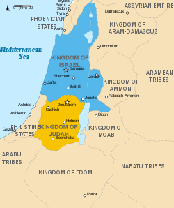
The Negev region, situated in the southern part of present-day Israel, has a long and varied history that spans thousands of years. Despite being predominantly a semi-desert or desert, it has historically almost continually been used as farmland, pastureland, and an economically significant transit area.
The ancient history of the Negev includes periods of Egyptian and Nabataean dominance, the rise of local cultures such as the Edomites, and notable agricultural and architectural developments during the Byzantine and early Islamic eras.
For historical purposes, the Negev can roughly be divided into four subregions: [1]
The Bible contains several traditions regarding the Beersheba-Arad Valley and the Negev Highlands, which can be broadly categorized into two groups. From the first group, older biblical scholarship inferred that the Negev was inhabited by the ancient Israelites during biblical times. According to the second group, a different people lived here; this group aligns more with the findings of more recent archaeology (see below).
(1) According to the Book of Genesis, already Abraham lived for a while in the central and biblical Negev after being banished from Egypt. [12] Notably, he spent a brief period living in Kadesh [Barnea] [13] and later resided as a guest in Beersheba, which at that time was purportedly part of the kingdom of the Philistine king of Gerar. [14] (2) Accordingly, Numbers 34:1–7 and Joshua 15:1–3 [15] are generally understood to mean that the biblical and central Negev actually belonged to God's Promised Land at least down to Kadesh Barnea at the southwestern fringes of the central Negev (but see below). This area is assigned to the Tribe of Judah [16] along with other more northerly areas. Simultaneously, the biblical and central Negev is assigned elsewhere to the Tribe of Simeon within the territory of the tribe of Judah. [17] (3) Hence, when the Israelites came from Egypt to Israel, according to Numbers 20:1–21:3, [18] only Aaron is not allowed to enter this land because he has sinned — the rest of the Israelites, however, can conquer the area.
(4) Conversely, according to Deuteronomy 1–2, [19] the area is revoked from the Israelites by God because everyone has sinned and God has also destined the land for the Edomites. [20] (5) The background for this is found in Genesis 32:3; 33:12–16, [21] where it is not Jacob, the ancestor of the Israelites, who lives there, but his brother Esau, the ancestor of the Edomites. These two grandsons of Abraham divide the promised land between them in Genesis 36:6–8 [22] so that this "Edomite land" will continue to be inhabited by Edomites. (6) According to the Books of Kings, the Edomites also live here. They are sometimes ruled by Israelite kings, as the Negev was purportedly part of the kingdom of the legendary king Solomon (in its entirety, all the way to the Red Sea), [23] and from the 9th century, with varied extension to the south, part of the Kingdom of Judah. [24] But the Edomites fight against them multiple times and regain their freedom. [25] [26] (7) The most common expression used in the Bible to refer to Israel as a whole is "from Dan to Beersheba." Once again, this excludes at least the central and southern Negev regions from "Israel". (8) Accordingly, it is not at all certain whether the border descriptions in Numbers 34 and Joshua 15 really include the Negev as part of the promised land, as Numbers 34 also presupposes an area of Edom west of the Jordan (which, according to Numbers 20:14-16, [27] begins at Kadesh as one of its southernmost locations). For that reason, it has recently occasionally been suggested that "Your southern border shall be from the Wilderness of Zin along the border of Edom" (Numbers 34:3) is to be understood as excluding the territory of the Edomites, and therefore at least the central and southern Negev, from the Promised Land. [28] [29] However, as of yet, this is still a minority opinion.
According to Egyptian written records, during the Bronze Age (up to the 13th century BCE) and the early Iron Age, it was the Shasu nomads who lived in the Negev and the Sinai Peninsula under Egyptian rule. [30] [6] [31] [32] Since these are referred to, among others, as the "tribes of the Shasu of Edom," it is assumed that from this ethnic group, the Edomites emerged later, and subsequently, the Idumeans (see below).
The Egyptians operated a copper mine in the Timna Valley, as evidenced by a Hathor temple from that period. [33] After the Egyptians withdrew, another group took over the copper mine. This group also constructed a fortress-like road station at the Yotvata oasis, notably using the casemate building technique, [34] [35] and established another copper mine at Khirbet en-Nahas. [36]
In the Beersheba–Arad Valley, a complex of several casemate buildings also emerged in the 12th century BCE, known as Tel Masos, [37] [38] the region's first capital (until it was replaced by nearby Tel Malhata as the new capital from the 10th to the 8th century BCE. [39] [40] ). From Tel Masos and Yotvata, this architectural style spread throughout the Negev region between the 11th to 8th centuries BCE, with sites like Tel Esdar, Khirbet en-Nahas, Beersheba and Arad adopting similar structures. Additionally, during this time, many more farms, known as "haserim" ("enclosed homesteads"), developed, especially along the streams and brooks up to the vicinity of the Philistine locations Nahal Patish and Tell el-Far'ah (South). Gazit notes that there were 36 Haserim of at least 0.25 hectares in size in the 11th century alone in the region, along with many smaller farms. [41] Moreover, in the same period, about 60 small casemate buildings appeared in the Negev Highlands. [42] Many of these sites also had additional smaller buildings, totaling several hundred. [43] [44] [45] [46] These settlements were likely involved in operating the copper mines, which is supported by the presence of copper slags from the Arabah in Negevite pottery. [47] [48] [49] [50] [51] [52] [53]
These archaeological finds are primarily interpreted in two different ways. Initially, biblical archaeologists interpreted the casemate buildings in the highlands as the garrisons mentioned in 2 Samuel 8:14, which states that King David built garrisons "throughout all Edom", [54] which is why they are still referred to as "fortresses" today. [52] This interpretation was gradually abandoned in the early 1990s: [55] Archaeologists, noting that Yotvata, Tel Masos, and the copper mines were built and operated more than 100 years before David's time, emphasizing that the buildings in the Negev were clearly no "fortresses," and showcasing distinct architectural styles and ceramics different from those in the Judean settlement area, proposed alternative theories. They suggested that either the ancestors of the Edomites built the Negev localities and operated the copper mines, governed by the "Tel Masos chiefdom", [56] [57] [58] [59] [60] or that alongside these nomadic people, a third, unknown sedentary people also lived there, with one of these two groups controlling the copper mines. [61] [62] [63] [64] However, in 2023, Tali Erickson-Gini once again advocated the older "Israel hypothesis," claiming that this interpretation had been consciously "swept under the rug" by archaeologists. [65]
External images | |
---|---|
Layout of a Negev farm. [66] | |
Terraces with dammed water. [67] | |
Terraces with growing grain. [68] |
The high number of Early Iron Age buildings in the Negev Highlands, with surveys identifying nearly 450 in total, [69] is surprising given the area's low rainfall, typically less than 200 mm/year. [70] However, the Negevites appear to have developed innovative agricultural techniques to cope with these conditions:
Michael Evenari demonstrated at his experimental Avdat farm that this farming method could successfully grow even grapes with less than 100 mm/year of rainfall. [73]
However, interpretations differ regarding the timing of terrace construction. It is clear that the majority of the millions [74] of wadi terraces still found in the Negev today originated in the Byzantine and Early Islamic periods [75] [76] [77] (see below). However, excavated blades, silos and threshing floors from the Iron Age, [78] [79] along with new Radiocarbon [80] and OSL datings, [81] [82] suggest that some terraces were built as early as the Iron Age or even earlier. [83] [84] [85] [86]
Conversely, research teams led by Israel Finkelstein investigated ancient dung heaps in the Negev mountains and at the Timna mines and discovered that in the central Negev, small livestock primarily grazed on wild-growing winter and spring plants, [87] [88] [89] while in the Timna area, they were mainly fed hay and grape pomace. [90] [89] Accordingly, they suggest that the practice of crop cultivation in the Negev mountains during the rainy season might have started later. If this is accurate, the Iron Age Negevites likely lived in the Negev mountains during the rainy season, practicing only livestock farming there. During the summer, they moved south to mine copper and imported grain and grape pomace from the Philistines and Judeans in the north. If one accepts the early dating of the agricultural terraces instead, it appears that Negevite society was structured such that they lived in the Negev mountains during the rainy season, engaging in crop and vine cultivation to stockpile supplies. During the summer, they moved down to the copper mines, mined copper, and fed their animals with the stored hay and grape pomace.
The political situation of the Negevites and their neighboring peoples as well as territorial fluctuations at this time largely depended on the surrounding political superpowers:
The economic background of this relocation appears to have been that deforestation had made further copper mining impossible: From the 12th to the 9th century BCE, copper mining was gradually intensified to such an extent that by the 9th century, a total of 460 tons per year were being extracted solely at Khirbet en-Nahas. [104] This, however, led to an overexploitation of natural resources, which eventually brought copper production to a complete halt, as indicated by the analysis of charcoal remains. [105] [106] [107]
Following the decline of copper mining, the Negevites appear to have increasingly focused on trade to the east. Camels seem to have been regularly used for trade starting from this period, as excavated camel and dromedary bones from the late 10th and early 9th centuries BCE suggest. [108] [109] It was also only from this time on that they expanded to the east of the Jordan river and founded Bozra and subsequently other towns along the King's Highway, which until recently were considered the "core territory" of Edom. [110] [111] [112] [113] [114] [115] The pottery found in these areas suggests that the same ethnic groups lived here as in the central Negev and (temporarily alongside Judeans [116] [117] [118] [119] [120] ) in the Beersheba-Arad Valley. Thus, when the Edomites relocated to Central Palestine, they left the Negev; subsequent survey results show that only 11 sites can be identified in the highlands from the following period [69] (see below).
Soon after, also the Idumeans living in ancient Edom east of the Jordan river were displaced by invading Arabian Qedarites and moved to join their kin in southern Judah. Subsequently, sometime between the late 4th and early 2nd century BC, these Qedarites were themselves pushed northwestward by the invading Nabateans. [121] [122] As a result, the Idumeans and Qedarites intermingled in southern Judah, [123] while the Nabateans settled in the former territories of Edom east of the river Jordan, the Negev, and Sinai, [124] [125] [126] [127] taking control of these areas and the ancient trade routes. [128] They established the so-called "desert towns" located along the Negev incense route at Avdat, Mampsis, Rehovot, Shivta, Nessana, and especially Elusa, which was to become the new capital and the only polis of the Negev. [129]
Previously, it was believed that the early Nabateans were responsible for the terraced fields in the Negev Highlands, [130] but archaeological evidence does not support this claim. [131] [132] Instead, the Nabateans are rightly famous for two other innovations in the arid desert landscape. First, they developed characteristic arched cisterns. More importantly, second, they constructed long water channels [133] from perennial springs to their cities and villages (as in En Erga, En Ziq, and Qasr Ruheibeh in the central Negev, and En Rahel and Moyat Awad in the Arabah), which functioned in their early time mainly not as agricultural farms but as caravan stops and trade stations. [134]
Josephus reports that the Maccabees conquered the Idumean border towns of Maresha and Adoraim and gave the Idumaeans a choice: either be circumcised and adopt Jewish customs or leave the area. [135] [136] Some historians believe that events unfolded largely as Josephus describes: The Hasmoneans invaded Idumaea, conquered many towns, and forcibly converted the Idumaeans, who reluctantly accepted this conversion "out of attachment to their homeland." [137] [138] [139]
External image | |
---|---|
Altar of Qos in Mamre [140] |
However, recent archaeological investigations have revealed (1) that Hasmonean conquests can be traced in only a few locations along the northern border of Idumaea (such as Khirbet er-Rasm, [141] possibly Maresha [142] and Lachish [143] ). In contrast, the vast majority of Idumaean settlements were abandoned without signs of conflict, [144] [145] [146] remained abandoned for some time, and were later resettled by the same population group after the Hasmonean period. (2) Archaeologically, it does not appear that the Judeans forced the Idumaeans to undergo circumcision or to adopt "Jewish customs." The Idumaeans were already practicing circumcision, [147] and other practices that later came to be seen as "Jewish" — such as ritual purification in mikvaot, ritual purification of vessels, specific burial customs, and avoidance of pork — appear to have been observed by the Idumaeans before they were by the Judeans. As a result, it is now occasionally suggested that, conversely, the Judeans may have adopted Idumaean customs. [148] [149] (3) Both a report by Josephus about the Qos-priest Costobarus and the discovery of a Herodian Qos sanctuary at Mamre suggest that the returning Idumaeans continued practicing their traditional religion nearly 100 years after their supposed conversion. [150] [151] [152] [153] [154]
Contrary to Josephus' account, it is now more frequently suggested — based on the archaeological evidence — that many Idumaeans left their homeland for still unexplained reasons in the 2nd century BCE, that those who remained voluntarily entered into an alliance with the Judeans, and that both the remaining and returning Idumaeans continued practicing their traditional religion. [155] [156] [157] The reports of forced conversions may have been either anti-Hasmonean propaganda [158] Hasmonean propaganda, [159] or more etiological than historical, intended to explain why the Idumaeans and Judeans shared similar customs. [160]
According to the Books of the Maccabees and Josephus, the Maccabees did not advance into the central and southern Negev. Hence, archaeological excavations in these areas reveal that the Nabataean religion was practiced there without interruption until the beginning of the Islamic period in the 7th century. [161] Nabatean political control of the Negev only ended when the Roman empire annexed their lands in 106 CE.
In the 4th century, Byzantine rule introduced Christianity to the region. Combined with a stable political climate, [162] this led to a significant population growth throughout the entire region. Immigrating Christians predominantly settled in the area of today's West Bank down to the Beersheba Valley, which had been most thoroughly extensively cleared of Judeans by the Romans. In the Beersheba Valley alone, the number of settlements surged from 47 in the Roman period (up to the 4th century) to 321 during the Byzantine era (4th - early 7th centuries); Beersheba expanded to an area of 90–140 ha, [163] making it even larger than nearby Gaza and Anthedon, each covering about 90 ha. [164]
One of the three additional clusters of Christian settlements were the Nabatean desert towns. [166] Most of these evolved into large agricultural villages with many smaller farms and villages around them. [167] Ultimately, the whole central Negev, extending down roughly to the Ramon Crater, was dotted with hundreds of small agricultural villages and farms. These were likely operated by Nabataeans assimilated to the Byzantine Empire, [168] [169] after Nabatean trade had declined starting from late Roman times. [122] On the character of Byzantine (and early Islamic) agriculture in the Negev, see below.
From 602 to 628, the Byzantine military was severely depleted during the Byzantine-Sassanian War and regained control over Palestine only with great difficulty. After that, despite forming alliances with several Bedouin tribes, such as the Banu Amilah, the Banu Ghassan, the Banu Judham, and the Banu Lakhm, who were migrating from the Arabian Peninsula to the southern Negev during this period, [170] the Arab forces encountered little resistance in their Islamic expansion into Palestine beginning in AD 634. By around AD 636, with the decisive Battle of the Yarmuk, the war was largely decided.
As mostly in the rest of the region of Palestine, the Islamic expansion left no archaeological trace in the Negev: [171] [172]
[...N]ot even one of the Negev towns was affected by the Islamic conquest. No hint of a violent invasion or destruction, or even a slight change in the material culture is found in the large-scale excavations of the sites. The archaeological findings point to an uninterrupted pattern of settlement which continued from the Byzantine period into the later stages of the early Islamic period.
— Gideon Avni, 2008 [173]
External image | |
---|---|
Nahal Oded: Mosque with pagan Matzevot. [174] |
There are also no clear signs of religious wars and forced conversions. In Nessana, it even appears that the same building was used simultaneously as both a church and a mosque. Similarly, in Nahal Oded (on the southwestern slope of the Ramon Crater), the same building seems to have served as a pagan cult place and a mosque at the same time. [175] Related to this phenomenon is the fact that the early Palestinian Muslims even integrated the Christian festivals of Easter, Pentecost, Christmas, and Saint Barbara into the Muslim calendar. [176] Therefore, on the eve of the Crusades, Palestine was still predominantly Christian. [177] Hence, Ibn al-Arabi, who visited Palestine at the end of the 11th century, could still write: "The country is theirs [the Christians'] because it is they who work its soil, nurture its monasteries and maintain its churches." [176]
The Arabic invasion, however, accelerated a trend toward deurbanization and ruralization, especially in the Negev, which had already started in Byzantine times, to which a number of factors contributed:
Already in the Byzantine period, 90% of the settlements in the Negev were agricultural farms and villages. Following the decline of the towns during the early Islamic period, the total number of settlements gradually decreased, [nb 1] yet the proportion of agricultural villages among these settlements further increased. According to Rosen, this shift of life from cities to rural areas is the reason why most Byzantine churches are found in the desert towns, whereas most early mosques are found in rural areas. [197] Also, further to the south, around the Ramon Crater at the southern fringes of the Negev highlands, the Negev Bedouin replicated the northern terrace architecture. [198] Haiman estimates that during the early Islamic period, there would have been about 300 individual farming villages, each with 80–100 residents, cultivating a total of approximately 6,500 hectares of agricultural land (nearly 3% of the total area of the Negev Highlands). [199] Newer surveys suggest that they might have cultivated even up to 30,000 – 50,000 hectares, which would correspond to nearly 14 – 23% of the area. [200] [201]
Meanwhile, the desert towns gradually died a quiet death: Elusa collapsed already towards the end of the Byzantine period, likely due to the Justinianic Plague and the Late Antique Little Ice Age. [202] Mampsis was abandoned either by the 7th or 8th century, Rehovot by the 8th century. The abandonment of Avdat, seemingly due to an earthquake, [203] [204] is now also dated to the 8th century. [205] The archaeologically poorly preserved Beersheba and its surroundings, including the revitalized towns Tel Masos, Tel Malhata and Tel Ira, may also have been abandoned by the 8th or 9th century. However, Shivta, Nessana, and the large Khirbet Futais (in the area of the former Philistine Nahal Patish) continued to exist at least until the 10th century. In Ayla, where the new inhabitants of the region resumed mining copper and started to mine gold, there can even be observed further growth; the towns were only abandoned in the 11th century. [206] [207] [192] [208]
From the 12th century onwards, as the Crusaders and then the Mamluks ravaged central and northern Palestine, most of the villagers and townspeople of the Negev had already migrated to these regions or to Europe. This, the war waged by the Crusaders against Southern Palestine as well, and the (not certain but likely) fact that the Mamluks prohibited permanent settlements in the Negev, led to the transformation of the Negev into a region inhabited solely by semi-nomadic and predominantly Muslim Bedouins. [209]
External image | |
---|---|
Reconstruction of a Byzantine/early Islamic agricultural system near Shivta. [210] |
If agriculture was already practiced on terraces during the Iron Age, this system was certainly further developed from the Byzantine period onwards:
Sela is a geographical name encountered several times in the Hebrew Bible, and applicable to a variety of locations.
The Negev or Negeb is a desert and semidesert region of southern Israel. The region's largest city and administrative capital is Beersheba, in the north. At its southern end is the Gulf of Aqaba and the resort city and port of Eilat. It contains several development towns, including Dimona, Arad, and Mitzpe Ramon, as well as a number of small Bedouin towns, including Rahat, Tel Sheva, and Lakiya. There are also several kibbutzim, including Revivim and Sde Boker; the latter became the home of Israel's first Prime Minister, David Ben-Gurion, after his retirement from politics.
Kadesh or Qadesh or Cades is a place-name that occurs several times in the Hebrew Bible, describing a site or sites located south of, or at the southern border of, Canaan and the Kingdom of Judah in the kingdom of Israel. Many modern academics hold that it was a single site, located at the modern Tel el-Qudeirat, while some academics and rabbinical authorities hold that there were two locations named Kadesh. A related term, either synonymous with Kadesh or referring to one of the two sites, is KadeshBarnea. Various etymologies for Barnea have been proposed, including 'desert of wanderings,' but none have produced widespread agreement.
The archaeology of Israel is the study of the archaeology of the present-day Israel, stretching from prehistory through three millennia of documented history. The ancient Land of Israel was a geographical bridge between the political and cultural centers of Mesopotamia and Egypt.
Israel Finkelstein is an Israeli archaeologist, professor emeritus at Tel Aviv University and the head of the School of Archaeology and Maritime Cultures at the University of Haifa. Finkelstein is active in the archaeology of the Levant and is an applicant of archaeological data in reconstructing biblical history. Finkelstein is the current excavator of Megiddo, a key site for the study of the Bronze and Iron Ages in the Levant.
Avdat or Ovdat, and Abdah or Abde, are the modern names of an archaeological site corresponding to the ancient Nabataean, Roman and Byzantine settlement of Oboda or Eboda in the Negev desert in southern Israel. It was inhabited with intermissions between the 3rd century BCE and the mid-7th century CE by Nabataeans, in their time becoming the most important city on the Incense Route after Petra, then by Roman army veterans, and Byzantines, surviving only for a few years into the Early Muslim period. Avdat was a seasonal camping ground for Nabataean caravans travelling along the early Petra–Gaza road in the 3rd – late 2nd century BCE. The city's original name was changed in honor of Nabataean King Obodas I, who, according to tradition, was revered as a deity and was buried there.
Tel Arad or Tell 'Arad is an archaeological tell, or mound, located west of the Dead Sea, about 10 kilometres west of the modern Israeli city of Arad in an area surrounded by mountain ridges which is known as the Arad Plain. The site is about 10.1 ha.
Ir Ovot is a small village in southern Israel. Located in the northeastern Arabah, it falls under the jurisdiction of Central Arava Regional Council. It operated as a kibbutz from 1967 until the 1980s. In 2019 it had a population of 54.
Qos also Qaus, or Koze was the national god of the Edomites. He was the Idumean structural parallel to Yahweh. The name occurs only twice in the Old Testament in the Book of Ezra and Nehemiah as an element in a personal name, Barqos, referring to the 'father' of a family or clan of perhaps Edomite/Idumaean nəṯīnīm or temple helpers returning from the Babylonian exile. Outside the Bible, Qos is frequently invoked in names found on documents recovered from excavations in Elephantine, where a mixed population of Arabs, Jews and Idumeans lived under the protection of a Persian-Mesopotamian garrison.
The Timna Valley is located in southern Israel in the southwestern Arava/Arabah, approximately 30 kilometres (19 mi) north of the Gulf of Aqaba and the city of Eilat. The area is rich in copper ore and has been mined since the 5th millennium BCE. During early antiquity, the area would have been part of the Kingdom of Edom.
Tel Sheva or Tel Be'er Sheva, also known as Tell es-Seba, is an archaeological site in the Southern District of Israel, believed to be the site of the ancient biblical town of Beer-sheba. The site lies east of modern Beersheba and west of the Bedouin town of Tel Sheva. Tel Sheva has been preserved and made accessible to visitors in the Tel Be'er Sheva National Park.
Maresha was an Iron Age city mentioned in the Hebrew Bible, whose remains have been excavated at Tell Sandahanna, an archaeological mound or 'tell' renamed after its identification to Tel Maresha. The ancient Judahite city became Idumaean after the fall of Judah in 586 BCE, and after Alexander's conquest of the region in 332 BCE became Hellenised under the name Marisa or Marissa. The tell is situated in Israel's Shephelah region, i.e. in the foothills of the Judaean Mountains, about 1.5 kilometres (0.93 mi) south of Beit Gubrin.
The Hebron Hills, also known as Mount Hebron, are a mountain ridge, geographic region, and geologic formation, constituting the southern part of the Judean Mountains. The Hebron Hills are located in the southern West Bank.
Mampsis or Memphis, today Mamshit, Kurnub, is a former Nabataean caravan stop and Byzantine city. In the Nabataean period, Mampsis was an important station on the Incense Road, connecting Southern Arabia through Edom, the Arabah and Ma'ale Akrabim, to the Mediterranean ports, as well as to Jerusalem via Beersheba and Hebron. The city covers 10 acres (40,000 m2) and is the smallest but best restored ancient city in the Negev Desert. The once-luxurious houses feature unusual architecture not found in any other Nabataean city.
Nessana, Modern Hebrew name Nizzana, also spelled Nitzana, is an ancient Nabataean city located in the southwest Negev desert in Israel close to the Egyptian border. It started by being a caravan station on the ancient Incense Road, protecting a western branch of the road which allowed access to Egypt to the west via the Sinai, and to Beersheba, Hebron and Jerusalem to the northeast. It was first used by Nabataean merchants, and later also by Christian pilgrims.
Edomite pottery, also known as 'Busayra Painted Ware' and 'Southern Transjordan-Negev Pottery' (STNP), is the name given to several ware types found in archaeological sites in southern Jordan and the Negev dated to the 7th and 6th centuries BCE. It is attributed to the Biblical people of the Edomites.
Edom was an ancient kingdom that stretched across areas in the south of present-day Jordan and Israel.
Wadi Feynan or Wadi Faynan is a major wadi and region in southern Jordan, on the border between Tafilah Governorate and Aqaba and Ma'an Governorates. It originates in the southern Jordanian Highlands with the confluence of Wadi Dana and Wadi Ghuweyr, and drains into the Dead Sea via Wadi Araba.
Tel Ira is an archaeological site in the Negev (Israel), overlooking the Beer Sheva valley. It was occupied in the Early Bronze III, Iron II, Persian, Hellenistic, Early Roman, Byzantine and Early Arab periods. It was first occupied in the 27th century BC. Its ancient/biblical name is unknown.
Tel Masos is an archaeological site in Israel, in northern Negev, about 15 kilometres southeast of Beer-Sheva, along the Beer-Sheva River. It is actually a cluster of different sites scattered around the wells in the area.
A considerable part of this comparatively fertile zone is covered by a block of shifting sand. Excavation has shown that there was already sand at Khalasa in the third to the fourth century A.D.
{{cite book}}
: CS1 maint: multiple names: authors list (link)The description of the first campaign of Seti I (1291 [B.C.]) on the north outer wall of the hypostyle hall of the Great Temple of Amun at Karnak provides an extended treatment of the Shasu. It places them in the 'hill country' of Khurru (Canaan) near Gaza (probably the western Negev, as there are no hills near Gaza), between the borders of Egypt at Tjaru and Pekanen (Canaan), where they were harassing the vassals of Egypt in Palestine (East of the Door, Scenes 1–11, esp. Scene 9, lines 104–108). [...] Some texts are even more precise. In Merneptah's Papyrus Anastasi 6.51–57 (COS 3.5), dated between 1226 and 1202, the 'Shasu of Edom' (probably Cisjordanian) are given permission to migrate west past the border fortresses at Tjeku (Sukkoth) into the Goshen region of Egypt. They are also called 'Shasu of Edom' in a letter from frontier official (638.14) during the reign of Siptah (fl. 1197–1191). In addition to the connection with Seir to be discussed below, Papyrus Harris 1 76.9–11 (COS 4.2; exploits of Rameses III written by Rameses IV; 1151 bc) speaks of the 'people of Seir among the tribes of Shasu.'
Further north, the so-called Iron IIA 'Israelite fortresses' of the Negev Highlands now show increasing evidence of being connected to the metal processing in the Arabah, most likely being used as waystations for the transportation of metal (and other trade items) towards the Meditreranean (or Egypt), probably controlled by the same group(s) that controlled the Arabah copper extraction [...]
There can be no doubt that the Central Negev fortresses and settlements constitute the principal evidence of Israelite settlement in the area south of Beer-Sheva.
The reevaluation of material evidence has included the reinterpretation of Negev sites. [... T]he interpretation of the Negev sites as 'fortresses' has itself come under severe attack.
Before 840 BCE, this was the location of the Tel Masos desert polity, which also encompassed the Iron IIA sites in the Negev Highlands, and which profited from participating in the mining of copper in the Arabah and the transportation of copper to the west.
However, a number of scholars have now questioned this interpretation, arguing that they were desert settlements of local people who were possibly changing from a nomadic to a more settled lifestyle [...]. The main reason is that the location of the sites and their construction does not fit what would be expected of fortresses; furthermore, there was no renewal of them at a later time when Judah definitely controlled this area. [...] Copper from the area (see below) probably formed an important part of this trade, and when the copper trade declined, the 'Tel Masos polity' also declined.
In regions that receive 200 mm or eight inches of rain a year dry farming is possible; yet due to the recurring periods of drought, only an average annual rainfall of 300 mm or 12 inches permits truly reliable agricultural productivity [...]. The agropastoral populations knew how to exploit this transition zone between the desert and the zones that had enough rain or which could be artificially irrigated. Herds that pastured in the steppes or the highlands during the rainy season in the winter were led at the end of the spring to the banks of the rivers or to wadis, dry river beds. Sheep and goats fed on the pastures along river banks or on the stubble in the fertile fields, and with the manure they fertilized the fields.
[...] Bruins (2007) has dated charcoal from sediments behind wadi channel terrace walls to the Iron Age [...], indicating the construction of the walls prior to the accumulation of the sediments. Thus, the terrace walls, agricultural dams for run-off irrigation, would constitute strong evidence for Iron Age farming. In addition, the presence of sickle segments in Iron Age sites in the region suggest reaping (e.g., Cohen and Cohen-Amin 2004:142).
JosAnt 13.257 f.
{{cite book}}
: |work=
ignored (help): Gradually abandoned over the course of the 2nd century.