Background
The ATSF and other railroads had to make special provisions for water supply in desert conditions, as non condensing steam locomotives [4] consumed a prodigious amount of water. The usual approach was to construct a dam to retain surface water, or to drill a series of wells, and store the water in a water tank. Railroad communities often grew up around these reservoirs or water stops. Ash Fork had been such a town from when the ATSF first arrived some years earlier although it had been a way point for stagecoach lines previously.
Railroads in the U.S. and elsewhere had been leaders in structural development. The masonry arch bridges and viaducts of the early 19th century had given way to bridges made mostly of steel, with considerable economy of material, construction cost, and time, and Bainbridge speculated that similar savings might be possible for dams. This dam was a significant departure from the more typical masonry construction. Already familiar with the construction of the ATSF's many steel bridges, Bainbridge decided to see whether steel construction could replace masonry in dams as well. The dam's light weight and prefabricated components must have made assembly easy relative to the laborious job of quarrying and setting stone.
Steel dams use relatively thin steel plates in contact with the water surface, with a framework of steel behind them transmitting the load to the ground. The plates are slanted upwards in the direction of water flow, so that the weight of the water puts compressive forces on the girders holding the plates up. This transmits force to the ground without the bending moment that a vertical wall of plates would engender. It was believed that these dams could be constructed faster and more cheaply than masonry dams.
Construction details
The dam was fabricated by the Wisconsin Bridge and Iron Company and shipped to the site in pieces for erection. Construction of the dam began in 1897 and was completed March 5, 1898, at a total cost of US$63,519 (equivalent to $2.3 million today).
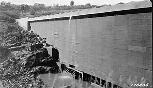
The structure gets its scalloped appearance from 24 curved 3⁄8-inch (9.5 mm) steel plates that slope downstream. Loose and rigid plates are alternated to compensate for a temperature range from 104 °F (40 °C) to −4 °F (−20 °C). The central steel section is 184 feet (56 m) long, 46 feet (14 m) high, and weighs about 460,000 pounds (210,000 kg). No spillway was provided; instead, the dam was designed to withstand overtopping of six feet (1.8 m) of water pouring directly over its crest.
It holds about 36,000,000 US gallons (140,000,000 L) of water when full.

Ash Fork is a census-designated place in Yavapai County, Arizona, United States. Its population was 396 at the 2010 U.S. Census, down from 457 in 2000.

Navajo Bridge is the name of twin steel spandrel arch bridges that cross the Colorado River in the Grand Canyon National Park in northern Coconino County, Arizona, United States. The newer of the two spans carries vehicular traffic on U.S. Route 89A (US 89A) over Marble Canyon between Bitter Springs and Jacob Lake, allowing travel into a remote Arizona Strip region north of the Colorado River including the North Rim of Grand Canyon National Park.
John Samuel Eastwood was an American engineer who built the world's first reinforced concrete multiple-arch dam on bedrock foundation at Hume Lake, California, in 1908, and was one of California's pioneers of hydroelectric power production. Eastwood's papers are held at the Water Resources Collections and Archives, University of California, Riverside.
The Bidwell Bar Bridge, in Oroville, California, is the name of two suspension bridges that cross different parts of Lake Oroville. The original Bidwell Bar Bridge was the first steel suspension bridge in California. The $35,000, 240-foot-long (73 m) original was completed in December 1855, and was built of materials transported from Troy, New York, via Cape Horn. Most of the money was put up by Judge Joseph Lewis, a Virginian who moved to Bidwell's Bar in 1849. The bridge originally crossed the Middle Fork Feather River and is the only one of several suspension bridges built in the area in the 1850s that still remains. It remained open to vehicle traffic until 1954.
The Niles Canyon Railway (NCRy) is a heritage railway running on the first transcontinental railroad alignment through Niles Canyon, between Sunol and the Niles district of Fremont in the East Bay of the San Francisco Bay Area, in California, United States. The railway is listed on the National Register of Historic Places as the Niles Canyon Transcontinental Railroad Historic District. The railroad is operated and maintained by the Pacific Locomotive Association which preserves, restores and operates historic railroad equipment. The NCRy features public excursions with both steam and diesel locomotives along a well-preserved portion of the first transcontinental railroad.

Pathfinder Dam is a masonry dam, located on the North Platte River, approximately 47 miles (76 km) southwest of Casper, Wyoming. It was originally constructed from 1905 to 1909 as part of the North Platte Project and has been modified several times since then. It is included on the National Register of Historic Places. Construction of the dam created Pathfinder Reservoir which provides water storage for 226,000 acres (910 km2) of irrigation in Wyoming and Nebraska. The dam is named for General John Charles Fremont, who had explored the area in 1842 and was nicknamed the "Pathfinder of the West."

The Redridge Steel Dam is a steel dam across the Salmon Trout River in Redridge, Houghton County, Michigan. Completed in 1901, it is a flat slab buttress dam constructed of steel, a relatively rare material for construction of dams, which are typically made of earthenworks, concrete, or masonry. Most sources indicate that it was one of only three such dams constructed in the United States, the other two being the Ashfork-Bainbridge Steel Dam and the Hauser Lake Dam, the last of which failed within a year of construction.

A steel dam is a type of dam that is made of steel, rather than the more common masonry, earthworks, concrete or timber construction materials.
The Wisconsin Bridge and Iron Company (WB&I) was a fabricator and erector of iron and steel bridges and other large structures.
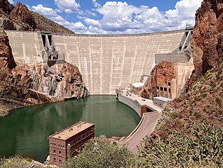
Theodore Roosevelt Dam is a dam on the Salt River located northeast of Phoenix, Arizona. The dam is 357 feet (109 m) high and forms Theodore Roosevelt Lake as it impounds the Salt River. Originally built between 1905 and 1911, the dam was renovated and expanded in 1989–1996. The dam is named after President Theodore Roosevelt. Serving mainly for irrigation, water supply, and flood control, the dam also has a hydroelectric generating capacity of 36 megawatts.

The Santa Fe, Prescott and Phoenix Railway (SFP&P) was a common carrier railroad that later became an operating subsidiary of the Atchison, Topeka and Santa Fe Railway in Arizona. At Ash Fork, Arizona, the SFP&P connected with Santa Fe's operating subsidiary, the Atlantic & Pacific Railroad mainline, that ran from California to Chicago. The SFP&P's 195-mile (314 km) line extended the Santa Fe Railway south into Phoenix. The SFP&P extended another 100 miles (160 km) to the east from Phoenix to Florence and Winkelman via the Phoenix and Eastern Railroad. The SFP&P also served several mines in the Prescott area, including the Derby Mine by way of the Summit (flag) Station at 'Prieta' in the Sierra Prieta range, through its various subsidiary railroads.

The Thomas Viaduct spans the Patapsco River and Patapsco Valley between Relay, Maryland and Elkridge, Maryland, USA. It was commissioned by the Baltimore and Ohio Railroad (B&O); built between July 4, 1833, and July 4, 1835; and named for Philip E. Thomas, the company's first president. Some claim it to be the world's oldest multiple arched stone railroad bridge. However, the Sankey Viaduct on the Liverpool and Manchester Railway was opened in 1830 and finally completed in 1833.

Lock and Dam No. 19 is a lock and dam located on the Upper Mississippi River near Keokuk, Iowa. In 1978, the Keokuk Lock and Dam was listed in the National Register of Historic Places, #78001234. In 2004, the facility was listed in the National Register of Historic Places as Lock and Dam No. 19 Historic District, #04000179 covering 1,605 acres (650 ha), 7 buildings, 12 structures, 1 object. The lock is owned and operated by the U.S. Army Corps of Engineers. The dam is owned and operated by Ameren Missouri.
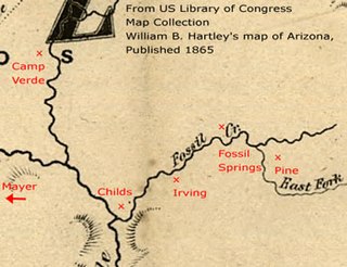
Childs-Irving Hydroelectric Facilities consisted of two 20th-century power plants, a dam, and related infrastructure along or near Fossil Creek in the U.S. state of Arizona. The complex was named an Historic Mechanical Engineering Landmark in 1971 and was added to the National Register of Historic Places 20 years later. Decommissioned in 2005, the plants no longer produce electricity, and much of the infrastructure—including the dam, the Irving Power Plant, and thousands of feet of concrete flumes—have been removed, and the creek's original flow has been restored.

Buffalo Bill Dam is a concrete arch-gravity dam on the Shoshone River in the U.S. state of Wyoming. It is named after the famous Wild West figure William "Buffalo Bill" Cody, who founded the nearby town of Cody and owned much of the land now covered by the reservoir formed by its construction. The dam is part of the Shoshone Project, successor to several visionary schemes promoted by Cody to irrigate the Bighorn Basin and turn it from a semi-arid sagebrush-covered plain to productive agricultural land. Known at the time of its construction as Shoshone Dam, it was renamed in 1946 to honor Cody.

Arrowrock Dam is a concrete arch dam in the western United States, on the Boise River in southwestern Idaho, east of Boise. Opened 109 years ago in 1915, it is located on the border of Boise and Elmore counties, upstream of the Lucky Peak Dam and reservoir. The spillway elevation for Arrowrock is 3,219 feet (981 m) above sea level and its primary purpose is to provide irrigation water for agriculture.

The Generals' Highway Stone Bridges, built in 1930, are part of the Generals' Highway from the General Grant Grove of giant sequoias in Kings Canyon National Park through Sequoia National Park. One bridge spans the Marble Fork of the Kaweah River in a wooded setting, while the other, similar bridge spans Clover Creek in a bare canyon.

Hauser Dam is a hydroelectric straight gravity dam on the Missouri River about 14 miles (23 km) northeast of Helena, Montana, in the United States. The original dam, built between 1905 and 1907, failed in 1908 and caused severe flooding and damage downstream. A second dam was built on the site in 1908 and opened in 1911 and comprises the present structure. The current Hauser Dam is 700 feet (210 m) long and 80 feet (24 m) high. The reservoir formed by the dam, Hauser Lake, is 25 miles (40 km) long, has a surface area of 3,800 acres (1,500 ha), and has a storage capacity of 98,000 acre-feet (121,000,000 m3) of water when full.

The Black Suspension Bridge spans the Colorado River in the inner canyon of Grand Canyon National Park. The span length is 440 feet (130 m). The bridge is part of the South Kaibab Trail and is the river crossing used by mules going to Phantom Ranch. The Black Bridge and Silver Bridge, located about 700 metres (2,300 ft) downstream, are the only spans in hundreds of river miles.

The Gillespie Dam Bridge is a through truss bridge spanning the Gila River in Maricopa County, in the U.S. state of Arizona. The bridge was constructed to bypass a concrete apron through the river in front of the Gillespie Dam, which was often closed due to flooding. Construction of the bridge started in 1925 and completed in 1927. From its opening until 1956, the bridge was part of U.S. Route 80 (US 80), a transcontinental highway between San Diego, California and Tybee Island, Georgia. The bridge was restored in 2012 by Maricopa County for the Arizona Centennial and now includes an educational interpretive center for visitors. The bridge became part of Historic US 80 in 2018.