
Theddlethorpe St Helen or East Theddlethorpe is a village and civil parish in the East Lindsey district of the county of Lincolnshire, England. It lies about 3 miles (5 km) north of Mablethorpe on the North Sea coast. Some seashore belongs to Saltfleetby-Theddlethorpe Dunes National Nature Reserve, consisting of sea dunes and saltwater and freshwater marshes. It is one of five UK locations where the natterjack toad is found. In 2011 the parish had a population of 525. The parish touches Gayton le Marsh, Mablethorpe and Sutton, Theddlethorpe All Saints and Withern with Stain. Theddlethorpe St Helen shares a parish council with Theddlethorpe All Saints.

Anderby is a village and civil parish in the East Lindsey district of Lincolnshire, England. It has a population of 335, according to the 2001 Census. increasing to 382 at the 2011 census.

Ashby by Partney is a village and former civil parish, now in the parish of Ashby with Scremby, in the East Lindsey district of Lincolnshire, England. It is situated to the south of the A158 road, and 2 miles (3 km) east from the town of Spilsby. It neighbours the village of Partney. In 1961 the parish had a population of 64. On 1 April 1987 the parish was abolished and merged with Scremby to form "Ashby with Scremby".

Ashby Puerorum is a small village and former civil parish, now in the parish of Greetham with Somersby, in the East Lindsey district of Lincolnshire, England. The village situated 6 miles (10 km) north-west from Partney, 4 miles (6 km) east from Horncastle, to the north of the A158 road, and to the west of Bag Enderby. In 1931 the parish had a population of 97. On 1 April 1936 the parish was abolished and merged with Somersby.

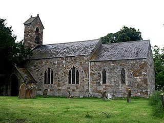
Bag Enderby is a village and former civil parish, now in the parish of Greetham with Somersby, in the East Lindsey district of Lincolnshire, England. It lies just north of the A158 road, 6 miles (10 km) north-east from Horncastle and 4 miles (6 km) north-west from Partney. In 1931 the parish had a population of 29. On 1 April 1936 the parish was abolished and merged with Somersby.

Maltby le Marsh is a village and civil parish in the East Lindsey district of Lincolnshire, England. The village is situated between Alford and Mablethorpe, and at the junction of the A1104 and A157 roads.

Belchford is a village and civil parish in the East Lindsey district of Lincolnshire, England. The village is situated approximately 4 miles (6 km) north of Horncastle and just to the east of the A153. At the 2011 Census, the population of the parish was 255.

Panton is a village in the civil parish of East Barkwith, in the East Lindsey of district, Lincolnshire, England. It is situated approximately 13 miles (20 km) north-east from the county town of Lincoln. In 1971 the parish had a population of 48. On 1 April 1987 the parish was abolished and merged with East Barkwith and Wragby.

Saleby is a village in the civil parish of Beesby with Saleby, in the East Lindsey district of Lincolnshire, England. It is on the Alford road to Louth, about 2 miles (3 km) north-east of Alford and 11 miles (18 km) south-east of Louth. The hamlet of Thoresthorpe is about 1 mile (1.6 km) south of the village.

Well is a small estate village and civil parish about 1.5 miles (2.4 km) south of the town of Alford, in the East Lindsey district of Lincolnshire, England. The population of the civil parish was 166 at the 2011 census. It is situated on the foot of the east entry to the Lincolnshire Wolds. The population of 166 as at the 2011 census includes the hamlet of Claxby St. Andrew. The village provides views of the gradually sloping hills towards the west.

Fulletby is a village and a civil parish in the East Lindsey district of Lincolnshire, England. It is in the Lincolnshire Wolds, and 3 miles (5 km) north-east from Horncastle, 9 miles (14 km) south from Louth, and 8 miles (13 km) north-west from Spilsby. The parish covers approximately 1,950 acres (8 km2). At the time of the 2011 census the population remained less than 100 and is included in the civil parish of Low Toynton.
Fulstow is a marsh village and civil parish in the East Lindsey district of Lincolnshire, England. It is situated 6 miles (10 km) north of Louth and 8 miles (13 km) south of Grimsby.

Cuxwold is a village and former civil parish, now in the parish of Swallow, in the West Lindsey district of Lincolnshire, England. It lies in the Lincolnshire Wolds, 4 miles (6 km) east from Caistor and 10 miles (16 km) south-west from Grimsby. In 1931 the parish had a population of 98. On 1 April 1936 the parish was abolished and merged with Swallow.

Withern is a village in the civil parish of Withern with Stain, in the East Lindsey district of Lincolnshire, England. It is situated on the A157 road, and 7 miles (11 km) south-east from Louth. Stain was once an independent parish but was combined with Withern when the old church of St John the Baptist was destroyed some centuries ago.
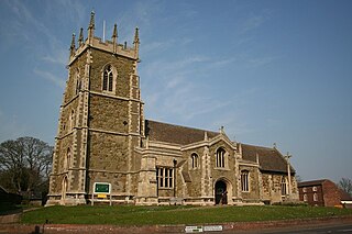
St Wilfrid's, Alford is the Church of England parish church in Alford, Lincolnshire, England. It is a Grade I listed building.

Marshchapel is a coastal village and civil parish in the East Lindsey district of Lincolnshire, England. It is approximately 11 miles (18 km) south-east from Grimsby and 13 miles (21 km) north-east from Louth. It includes the hamlets of West End and Eskham.

Hagnaby is a small village and former civil parish, now in the parish of East Kirkby, in the East Lindsey district of Lincolnshire, England. It is 4 miles (6.4 km) south-west from Spilsby. In 1961 the parish had a population of 18. On 1 April 1987 the parish was abolished and merged with East Kirkby.

Driby is a village and former civil parish, now in the parish of South Thoresby, in the East Lindsey district of Lincolnshire, England. It is situated 4 miles (6.4 km) west from the town of Alford. In 1961 the parish had a population of 42. On 1 April 1987 the parish was abolished and merged with South Thoresby.
North Reston is a village and former civil parish, now in the parish of Reston, in the East Lindsey district of Lincolnshire, England, and on the A157 road about 4 miles (6 km) south-east from the town of Louth. In 1961 the parish had a population of 36. On 1 April 1987 the parish was abolished and merged with South Reston to form "Reston".
Gayton le Marsh is a village and civil parish in the East Lindsey district of Lincolnshire, England It is situated 6 miles (9.7 km) south-east from the town of Louth and about 6 miles (9.7 km) north from Alford. The population of the civil parish was 155 at the 2011 census.

