
Benson is a town in Hamilton County, New York, United States. The population was 221 at the 2020 census. The town is on the southern border of Hamilton County and is northwest of Schenectady. The current Town Supervisor is John M. Stortecky.
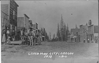
Greenhorn is a nearly non-populated city in Baker and Grant counties in the U.S. state of Oregon. It straddles the Blue Mountain ridge, so that it is located in both Grant County and Baker County. As most of the city is situated in Baker County, and the early residents considered Baker City to be more convenient, for administrative purposes it is considered to be in Baker County.

The Blue Ridge Parkway is a National Parkway and All-American Road in the United States, noted for its scenic beauty. The parkway, which is the longest linear park in the U.S., runs for 469 miles (755 km) through 29 counties in Virginia and North Carolina, linking Shenandoah National Park to Great Smoky Mountains National Park. It runs mostly along the spine of the Blue Ridge, a major mountain chain that is part of the Appalachian Mountains. Its southern terminus is at U.S. Route 441 (US 441) on the boundary between Great Smoky Mountains National Park and the Qualla Boundary of the Eastern Band of Cherokee Indians in North Carolina, from which it travels north to Shenandoah National Park in Virginia. The roadway continues through Shenandoah as Skyline Drive, a similar scenic road which is managed by a different National Park Service unit. Both Skyline Drive and the Virginia portion of the Blue Ridge Parkway are part of Virginia State Route 48 (SR 48), though this designation is not signed.

The geography of North Carolina falls naturally into three divisions — the Appalachian Mountains in the west, the central Piedmont Plateau, and the eastern Atlantic Coastal Plain. North Carolina covers 53,819 square miles (139,391 km2) and is 503 miles (810 km) long by 150 miles (241 km) wide. The physical characteristics of the state vary from the summits of the Smoky Mountains, an altitude of near seven thousand feet (2,130 m) in the west, sloping eastward to sea level along the coast and beaches of the Atlantic Ocean.

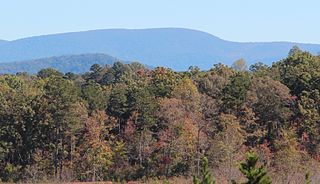
The Blue Ridge Mountains are a physiographic province of the larger Appalachian Highlands range. The mountain range is located in the Eastern United States and extends 550 miles southwest from southern Pennsylvania through Maryland, West Virginia, Virginia, North Carolina, South Carolina, Tennessee, and Georgia. The province consists of northern and southern physiographic regions, which divide near the Roanoke River gap. To the west of the Blue Ridge, between it and the bulk of the Appalachians, lies the Great Appalachian Valley, bordered on the west by the Ridge and Valley province of the Appalachian range.
Springer Mountain is a mountain located in the Chattahoochee National Forest on the border of Fannin and Gilmer counties. Located in the Blue Ridge Mountains in northern Georgia, the mountain has an elevation of about 3,770 feet (1,149 m). Springer Mountain serves as the southern terminus for the Appalachian and Benton MacKaye trails.

Apple Orchard Mountain is a peak of the Blue Ridge Mountains in Virginia.
Blue Ridge Summit is an unincorporated community and census-designated place in Franklin County, Pennsylvania, United States, southwest of Gettysburg in the central part of the state, adjoining Pennsylvania's southern border with Maryland. It is less than 3 miles (5 km) east of Pen Mar, Maryland. The population of Blue Ridge Summit was 887 at the 2020 census.

Blue Mountain, Blue Mountain Ridge, or the Blue Mountains of Pennsylvania is a ridge of the Appalachian Mountains in eastern Pennsylvania. Forming the southern and eastern edge of the Ridge-and-Valley Appalachians physiographic province in Pennsylvania, Blue Mountain extends 150 miles (240 km) from the Delaware Water Gap on the New Jersey border in the east to Big Gap in Franklin County in south-central Pennsylvania at its southwestern end.

Mount Pisgah is a mountain in the Appalachian mountain range and part of the Blue Ridge Mountains of North Carolina, United States. The mountain's height is 5,721 feet above sea level, and it sits approximately 15 miles southwest of Asheville, near the crossing of the boundaries of Buncombe, Haywood, Henderson and Transylvania counties. It is located on the border of Buncombe and Haywood counties, close to the point where Henderson and Transylvania meet them, but not actually within the latter two counties. The mountain is easily accessible via a hiking trail from the Blue Ridge Parkway, near the Pisgah Inn.

Pisgah National Forest is a National Forest in the Appalachian Mountains of western North Carolina. It is administered by the United States Forest Service, part of the United States Department of Agriculture. The Pisgah National Forest is completely contained within the state of North Carolina. The forest is managed together with the other three North Carolina National Forests from common headquarters in Asheville, North Carolina. There are local ranger district offices located in Pisgah Forest, Mars Hill, and Nebo.

Short Hill Mountain is a mountain ridge of the Blue Ridge Mountains in northwest Loudoun County, Virginia.

The U.S. state of Georgia is commonly divided into four geologic regions that influence the location of the state's four traditional physiographic regions. The four geologic regions include the Appalachian foreland, Blue Ridge, Piedmont, and Coastal Plain. These four geologic regions commonly share names with and typically overlap the four physiographic regions of the state: the Appalachian Plateau and adjacent Valley and Ridge; the Blue Ridge; the Piedmont and the Coastal Plain.

Waterrock Knob is a mountain peak in the U.S. state of North Carolina. It is the highest peak in the Plott Balsams and is the 16th-highest mountain in the Eastern United States.

Raven Rocks is a spur of Blue Ridge Mountain in Jefferson County, West Virginia. The peak is located just north of Jefferson County's border with Clarke County, Virginia and west of its border with Loudoun County, Virginia.

Peak Mountain is a mountain in the North Carolina High Country, near the town of Seven Devils. It is known by several other names such as Tynecastle Peak, Invershiel Peak and Dunvegan Peak. It is wholly in the Pisgah National Forest. Its elevation reaches 4,921 feet (1,500 m).
Humpback Mountain is a mountain in the North Carolina High Country and the Pisgah National Forest, located southwest of Linville Falls. The mountain is accessible along the Blue Ridge Parkway, which ride along its eastern slope. The peak reaches an elevation of 4,245 feet (1,294 m), in Avery County; while the overall mountain is also in McDowell County. Two ridges, Mill Ridge and Dividing Ridge, form from the western side of the mountain.
Love is an unincorporated community in Augusta County, Virginia, United States.
Little Frog Mountain is a mountain located in southeastern Tennessee in the United States. It is located in the Blue Ridge province of the Appalachian Mountains, and has an elevation of 3,337 feet (1,017 m).

