
The Illinois and Michigan Canal connected the Great Lakes to the Mississippi River and the Gulf of Mexico. In Illinois, it ran 96 miles (154 km) from the Chicago River in Bridgeport, Chicago to the Illinois River at LaSalle-Peru. The canal crossed the Chicago Portage, and helped establish Chicago as the transportation hub of the United States, before the railroad era. It was opened in 1848. Its function was partially replaced by the wider and deeper Chicago Sanitary and Ship Canal in 1900, and it ceased transportation operations with the completion of the Illinois Waterway in 1933.

The National Register of Historic Places in the United States is a register including buildings, sites, structures, districts, and objects. The Register automatically includes all National Historic Landmarks as well as all historic areas administered by the U.S. National Park Service. Since its introduction in 1966, more than 97,000 separate listings have been added to the register.
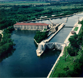
The Lockport Powerhouse is an American run-of-the-river dam used by the Metropolitan Water Reclamation District of Greater Chicago to control the outflow of the Sanitary and Ship Canal and limit the diversion of water from Lake Michigan into the Des Plaines River.

U.S. Route 66 was a United States Numbered Highway in Illinois that connected St. Louis, Missouri, and Chicago, Illinois. The historic Route 66, the Mother Road or Main Street of America, took long distance automobile travelers from Chicago to Southern California. The highway had previously been Illinois Route 4 and the road has now been largely replaced with Interstate 55 (I-55). Parts of the road still carry traffic and six separate portions of the roadbed have been listed on the National Register of Historic Places.

Lock and Dam No. 12 is a lock and dam located on the Upper Mississippi River at Bellevue, Iowa, United States. The movable portion of the dam starts at the locks adjacent to the Iowa shore and is 849 feet (258.8 m) long, consisting of seven tainter gates and three roller gates. It connects to a 200-foot (61.0 m) storage yard and continues toward the Illinois shore with a 2,750-foot (838.2 m) non-submersible dike, a 1,200-foot (365.8 m) submersible dike and a 3,130-foot (954.0 m) non-submersible dike. The non-submersible sections are separated from the submersible section with two 120-foot (36.6 m) transitional dikes. The main lock is 110 feet (33.5 m) wide by 600 feet (182.9 m) long. There is also an incomplete auxiliary lock. In 2004, the facility was listed in the National Register of Historic Places as Lock and Dam No. 12 Historic District, #04000172 covering 1,017 acres (4.1 km2), 1 building, 3 structures, and 4 objects.

Lock and Dam No. 13 is a lock and dam located on the Upper Mississippi River above Fulton, Illinois and Clinton, Iowa, United States. This facility offers visitors a view of the barges and boats locking through on the widest pool in the Upper Mississippi River.

Lock and Dam No. 14 is a lock and dam located near LeClaire, Iowa on the Upper Mississippi River above Davenport, Iowa and Moline, Illinois. The movable portion of the dam is 1,343 feet (409.3 m) long and consists of 13 tainter gates and 4 roller gates. Connected to it is a 1,127 feet (343.5 m) long non-submersible rock fill dike which extends to the Illinois side. The main lock is 110 feet (33.5 m) wide by 600 feet (182.9 m) long. The site on the National Register of Historic Places as the Lock and Dam No. 14 Historic District (#04000174) listed in 2004 consisting of 3,043 acres (12.3 km2), 1 building, 6 structures, and 2 objects. It was completed in two phases, the first as part of the six foot channel project from 1921 to 1924, which included a lock and canal bypassing a hazardous rapids. The second phase was part of the nine foot channel project from 1935 to 1939 and included the main dam and the current main lock.

Lock and Dam No. 15 is a lock and dam located on the Upper Mississippi River. It spans the river between Rock Island, Illinois and Davenport, Iowa. Lock and Dam 15 is the largest roller dam in the world, its dam is 1,203 feet (366.7 m) long and consists of nine 109 feet (33.2 m) non-submersible, non-overflow roller gates and two 109 feet (33.2 m) non-submersible overflow roller gates. It is unusual among the upper Mississippi River dams in that it has only roller gates, has different sizes and types of roller gates, it is not perpendicular to the flow of the river and is one of the few facilities that has a completed auxiliary lock. The main lock is 110 feet (33.5 m) wide by 600 feet (180 m) long and its auxiliary lock is 110 feet (34 m) wide by 360 feet (110 m) long. In 2004, the facility was listed in the National Register of Historic Places as Lock and Dam No. 15 Historic District, #04000175 covering 3,590 acres (1,450 ha), 2 buildings, 9 structures, and 1 object.

Lock and Dam No. 18 is a lock and dam located near Gladstone, Illinois and Burlington, Iowa on the Upper Mississippi River around river mile 410.5. The movable dam is 1,350 feet (411.5 m) and consists of 3 roller gates and 14 tainter gates. The lock is 110 feet (33.5 m) wide by 600 feet (182.9 m) long. In 2004, the facility was listed in the National Register of Historic Places as Lock and Dam No. 18 Historic District, #04000178 covering 2,049 acres (8.3 km2), 1 building, 4 structures and 4 objects.

Lock and Dam No. 20 is a lock and dam located on the Upper Mississippi River, the lock side in Canton, Missouri and the dam crossing to Meyer, Illinois.

Lock and Dam No. 21 is a lock and dam located at Quincy, Illinois on the Upper Mississippi River around river mile 324.9. The movable portion of the dam is 1,265 feet (385.6 m) long and consists of three roller gates and ten tainter gates. A 1,400 feet (426.7 m) long submersible dike continues to the Missouri shore. The main lock is 110 feet (33.5 m) wide by 600 feet (182.9 m) long and there is also an incomplete auxiliary lock. In 2004, the facility was listed in the National Register of Historic Places as Lock and Dam No. 21 Historic District, #04000181 covering 1,075 acres (4.4 km2), 1 building, 4 structures, 4 objects.

Lock and Dam No. 22 is a lock and dam located near Saverton, Missouri, on the Upper Mississippi River around river mile 301.2. The movable portion of the dam is 1,224 feet (373.1 m) long and consists of three roller gates and ten tainter gates. A 1,600 feet (487.7 m) long submersible earthen dike extends to a flood control levee on the Illinois shore. The main lock is 110 feet (33.5 m) wide by 600 feet (182.9 m) long; there is also an incomplete auxiliary lock. In 2004, the facility was listed in the National Register of Historic Places as Lock and Dam No. 22 Historic District, #04000182 covering 1,268 acres (5.1 km2), 1 building, 5 structures, 4 objects.

The Joliet Iron and Steel Works was once the second largest steel mill in the United States. Joliet Iron Works was initially run from 1869 to 1936. Joliet Steel Works eventually became unprofitable, and all operations were ceased by the early 1980s.

Starved Rock Lock and Dam, also known as Lock and Dam No. 6, is a lock and dam facility managed by the U.S. Army Corps of Engineers along the Illinois River, near Starved Rock. It is part of the Illinois Waterway and was constructed between 1926 and 1933. The lock and dam was added to the National Register of Historic Places as the Starved Rock Lock and Dam Historic District in 2004.
Walter Mickle Smith, Sr. was a civil engineer who worked primarily on U.S. dams and waterway projects. He was a consulting engineer on the construction of the Panama Canal and Panama Canal Locks and later served as design engineer for the New York Board of Water Supply. He spent much of his career with the State of Illinois waterways division and was its chief engineer until his retirement in 1937. Several of his works built in the 1920s and 1930s as part of the Illinois Waterway project are listed on the National Register of Historic Places, including portions of the Brandon Road Lock and Dam, the Dresden Island Lock and Dam, the Lockport Lock and Power House, and the Marseilles Lock and Dam.

The Dresden Island Lock and Dam is a 23.4-acre (9.5 ha) Lock and Dam complex on the Illinois River in Morris, Illinois. The dam was completed in 1933 and designed by engineer Walter Mickle Smith. It was listed on the National Register of Historic Places in 2004. The listing included one contributing building and three contributing structures.

The Marseilles Lock and Dam, also known as Lock and Dam 5, is a lock and dam complex on the Illinois River at Marseilles, Illinois. The complex includes a lock, dam, control station, boiler house, and a 2.5 miles (4.0 km) section of navigation canal. The state of Illinois began work on the complex in 1920 by digging the canal, which was completed in 1925. The state also began construction on the lock, dam, and control station; however, due to financial difficulties these projects were finished by the U.S. Army Corps of Engineers. Walter Mickle Smith was chief design engineer for the complex. The complex was completed in 1933. The lock has a drop of 24 feet.

LaGrange Lock and Dam is a lock and dam complex on the Illinois River at Versailles, Illinois. The structure includes a 1,066 feet (325 m) dam and a 110 by 600 feet lock. The U.S. Army Corps of Engineers built the complex from 1936 to 1939; A.F. Griffin designed the lock and dam, while Paul Le Gromwell designed the control station. The lock and dam, as well as a similar lock and dam near Peoria, were needed when the authorized channel depth was raised to nine foot. The Peoria and LaGrange locks replaced older locks on the lower Illinois River. The lock uses Chanoine wicket gates, which allow for navigation on the river, rather than the Tainter gates seen elsewhere on the river.

The Peoria Lock and Dam is a historic lock and dam complex on the Illinois River at Creve Coeur, Illinois. The complex was built in 1938-39 as part of an effort to make the river navigable and establish a route for barges between Chicago and the Mississippi River. The U.S. Army Corps of Engineers designed the complex; their influence is particularly evident in the dam's control station, as the State of Illinois designed most other dam control stations along the river. The lock has a standard 100-by-600-foot chamber, similar to other locks on the river, and a vertical lift of 11 feet (3.4 m). The dam is 536 feet (163 m) long and includes 108 wicket gates and a Tainter gate; it is one of two Illinois dams that still use wicket gates. The control station is for the most part a large, functional building, though it has Art Deco surrounds at the main entrance. The district also contains an original maneuver boat designed to raise and lower the dam's wicket gates; the boat is still used and is one of four boats of its kind left in the United States.

Thomas J. O'Brien Lock & Dam is a stop lock in the Hegewisch neighborhood on the South Side of Chicago at the confluence of the Grand Calumet River and Little Calumet River, which form the Calumet River. It is a component of the Chicago Area Waterway System (CAWS), which is, itself, a part of the Illinois Waterway, which links the Mississippi River and the Great Lakes.


