
Paulding County is a county in the Northwest region of the U.S. state of Georgia. Part of Metro Atlanta, it had an estimated population of 168,661 in 2020. The county seat is Dallas.

Snowmass Village is a home rule municipality in Pitkin County, Colorado, United States. The population was 3,096 at the 2020 census. A popular winter resort location for skiing and snowboarding, the town is well known as the location of the Snowmass ski area, the largest of the four nearby ski areas operated collectively as Aspen/Snowmass. In 2010, the accidental discovery by a bulldozer operator of fossilized elements of a Pleistocene ecosystem in the ice age lake bed at the Ziegler Reservoir put Snowmass Village prominently on the paleontological map of North America.

North Decatur is an unincorporated community and census-designated place (CDP) in DeKalb County, Georgia, United States. The population was 18,511 in 2020.
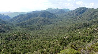
The Coronado National Forest is a United States National Forest that includes an area of about 1.78 million acres (7,200 km2) spread throughout mountain ranges in southeastern Arizona and southwestern New Mexico.

Mount Oglethorpe is a mountain located in Pickens County, Georgia, United States. The southernmost peak in the Blue Ridge Mountains, the mountain has an elevation of 3,288 feet (1,002 m), making it the highest point in Pickens County, and the Atlanta Metropolitan Area.
Crane Hill is an unincorporated community in Cullman County, Alabama, United States, located in the southwestern portion of the county. The community of Crane Hill traces its history back to 1806, when the first settlers recorded their land titles. The area is named after the Sandhill Crane who fished the streams and roosted on a hill located just north of Mt. Zion Road.

The Baldface-Royce Range is a range of mountains in western Maine and eastern New Hampshire, in the United States. They are located in the town of Chatham, New Hampshire, and the townships of Bean's Purchase, New Hampshire, and Batchelders Grant, Maine, in the eastern part of the White Mountains.

Burnt Hills is a hamlet within the town of Ballston, in Saratoga County, New York, United States. Its ZIP code is 12027. It is situated along NY 50, approximately 14 miles south of downtown Saratoga Springs, and 8.5 miles north of downtown Schenectady. The hamlet and its surrounding areas send their children to schools in the Burnt Hills-Ballston Lake Central School District, affectionately referred to as "BH-BL". The school district's offices are on Lakehill Road within the Burnt Hills hamlet.

Rum Hill is a mountain located in Central New York Region of New York northwest of the Hamlet of Pierstown. Red House Hill is located southeast, Metcalf Hill is located south, Allen Lake and Mohegan Hill are located north-northwest and Otsego Lake is located east of Rum Hill.
Kilkenny Hill is a mountain in the Central New York region of New York, United States. It is located northwest of Unadilla, New York. Kilkenny Hill is part of the Northern Allegheny Plateau Ecoregion.
Round Top is a mountain located in the Catskill Mountains of New York north of New Kingston. Burnt Hill is located south of Round Top and Mill Mountain is located west-southwest.
Mill Mountain is a mountain located in the Catskill Mountains of New York northwest of New Kingston. Mount Pisgah is located south of Mill Mountain and Burnt Hill is located east.
Morgan Hill is a mountain in the central part of the state of New York. It is located north-northeast of Truxton in Cortland County with a small portion in Onondaga County. The portion of the mountain within Onondaga County is the highest point in the county.
Gallis Hill is a 794-foot-tall (242 m) mountain in the Catskill Mountains region of New York. It is located northwest of Kingston in Ulster County. Jockey Hill is located north-northeast, and Morgan Hill is located west of Gallis Hill. In 1927, the Conservation Department built a steel fire lookout tower on the mountain. In 1950, the tower was closed and disassembled then moved to Overlook Mountain, where it still remains today.
Burnt Mountain is a summit in the Adirondack Mountains, located in Herkimer County, New York, USA. It is located east-southeast of Old Forge in the Town of Webb. Fernow Mountain is located north-northeast and McCauley Mountain is located west of Burnt Mountain.
Rossman Hill is a mountain in Schoharie County, New York. It is located northwest of North Blenheim. Fulton Hill is located northwest, Towpath Mountain is located east-northeast, and Burnt Hill is located south of Rossman Hill.
Leonard Hill is a 2,592-foot-tall (790 m) mountain in Schoharie County, New York. It is located east-southeast of North Blenheim. Safford Hill is located northwest and Hubbard Hill is located southeast of Leonard Hill. In 1948, the Conservation Commission built an 80-foot-tall (24 m) steel fire lookout tower on the mountain. The tower ceased fire watching operations at the end of the 1988 season and was officially closed in early 1989. The tower remains on the summit, but is closed to the public. A local group is planning to restore the tower and reopen it to the public.
Rattle Hill is a mountain in Sullivan County, New York. It is located north-northwest of Grooville. Beech Mountain is located east-northeast, Burnt Hill is located west-southwest and Gray Hill is located south-southwest of Rattle Hill.

