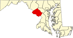
Cabin John-Brookmont, Maryland

Last updated
Cabin John-Brookmont
Former CDP
USA Maryland location map.svg
Red pog.svg
Cabin John-Brookmont
Location within the state of Maryland
Usa edcp location map.svg
Red pog.svg
Cabin John-Brookmont
Cabin John-Brookmont (the United States)
Coordinates: 38°58′02″N77°08′51″W / 38.96722°N 77.14750°W / 38.96722; -77.14750 Coordinates: 38°58′02″N77°08′51″W / 38.96722°N 77.14750°W / 38.96722; -77.14750
CountryUnited States
State Maryland
Counties Montgomery
Area
  Land2.6 sq mi (6.8 km2)
  Water1.0 sq mi (2.5 km2)
Elevation
36 ft (11 m)
Population
 (1990)
  Total5,341
Time zone UTC−5 (Eastern (EST))
  Summer (DST) UTC−4 (EDT)
ZIP codes
20816, 20818
Area code(s) 240 & 301
FIPS code 24-12087 [1]

Cabin John-Brookmont was a census-designated place in Montgomery County, Maryland (adjacent to Washington, D.C.) during the 1980 and 1990 censuses, which included the primary communities of Cabin John and Brookmont. The population recorded in 1990 was 5,341 and consisted of 2,168 housing units. [2] The census area disbanded to form Cabin John and Brookmont in 2000. [3] The ZIP codes serving the area are 20816 and 20818.

Geography

Historical population
CensusPop.
1980 5,135
1990 5,3414.0%
source: [4] [5]

Located at 38.96737 north and 77.14763 west, [6] the census area of Cabin John-Brookmont was bounded by the census areas of Potomac to the northwest, McLean (the Potomac River) to the south and Bethesda to the northeast. [7] The land area of the CDP was 2.7 square miles. [8]

Related Research Articles

Potomac Heights, Maryland Census-designated place in Maryland, United States

Potomac Heights is a census-designated place (CDP) in Charles County, Maryland, United States. The population was 1,117 at the 2010 census. It has a volunteer fire department and numerous older rambler homes built for workers at the nearby U.S. Navy munitions plant in Indian Head.

Brunswick, Maryland City in Maryland

Brunswick is a city in southwestern Frederick County, Maryland, United States. The city is located on the north bank of the Potomac River; Loudoun County, Virginia occupies the opposite shore. The population of Brunswick was 5,870 at the 2010 census. There are three schools serving Brunswick: Brunswick Elementary School, Brunswick Middle School, And Brunswick High School.

Rosemont, Maryland Village in Maryland

Rosemont is a village in Frederick County, Maryland, United States. The population was 294 at the 2010 census. Maryland state routes 79 and 871 pass through Rosemont.

Brookmont, Maryland census-designated place in Maryland, United States

Brookmont is a census-designated place and an unincorporated area in Montgomery County, Maryland, United States. Brookmont is often considered part of neighboring Bethesda because it falls within Bethesda's 20816 zip code.

Cabin John, Maryland census-designated place in Maryland, United States

Cabin John is a census-designated place and an unincorporated area in Montgomery County, Maryland, United States.

Glen Echo, Maryland Town in Maryland, United States

Glen Echo is a town in Montgomery County, Maryland, United States, that was chartered in 1904. The population was 255 at the 2010 census.

Poolesville, Maryland Town in Maryland

Poolesville is a town in the western portion of Montgomery County, Maryland, United States. The population was 4,883 at the 2010 United States Census. It is surrounded by the Montgomery County Agricultural Reserve, and is considered a distant bedroom community for commuters to Washington, D.C.

Potomac, Maryland Census-designated place in Maryland, United States

Potomac is a census-designated place (CDP) in Montgomery County, Maryland, United States, named after the nearby Potomac River. In 2013, CNNMoney listed Potomac as the most affluent town with more than 25,000 residents in the United States, based on median household income. Potomac is also the seventh-most top-educated American small town according to Forbes. Bloomberg Businessweek labeled Potomac as the twenty-ninth-richest zip code in the United States in 2011, stating that it had the largest population of any U.S. town with a median income of more than $240,000. In 2012, The Higley Elite 100 published a list of highest-income neighborhoods by mean household income, which included four neighborhoods in Potomac; one of these neighborhoods, "Carderock-The Palisades" was ranked the highest-income neighborhood in the United States, followed by "Beverly Hills-North of Sunset" in Beverly Hills, California and "Swinks Mill-Dominion Reserve" of McLean, Virginia. More recently, two Potomac neighborhoods were ranked among the ten wealthiest neighborhoods in the country by CNBC in 2014. In 2018, data from the American Community Survey revealed that Potomac was the sixth-wealthiest city in the United States. Many Potomac residents work in nearby Washington, D.C.

Accokeek, Maryland Census-designated place in Maryland, United States of America

Accokeek, "at the edge of the hill" in Algonquin, is a census-designated place (CDP) located in Prince George's County, Maryland, United States. The CDP is located on the Potomac River, borders Charles County and is approximately 17 miles from Washington. It is a part of the Washington metropolitan area. The population of the CDP, as of the 2010 United States Census was 10,573, making it the 118th most populous place in the state of Maryland.

Eagle Harbor, Maryland Town in Maryland, United States

Eagle Harbor is an incorporated town in the far southeast corner of Prince George's County, Maryland, United States, and near the rural community of Aquasco that is known as a historic African American community founded in 1925. The population was 63 at the 2010 census. The Chalk Point Generating Station, owned by NRG Energy, which was sold to Mirant by the Potomac Electric Power Company (PEPCO) in 2000, is located adjacent to the town.

Fort Washington, Maryland Census-designated place in Maryland

Fort Washington is an unincorporated area and census-designated place in Prince George's County, Maryland, United States. It borders the capital of the United States of America, Washington, D.C., situated just south of the downtown district. As of the 2010 census it had a population of 23,717. Fort Washington is a prosperous community with an African American majority population. The Fort Washington community is located west of Maryland Route 210, with some additional area to the east of the highway.

Friendly, Maryland Census-designated place in Maryland

Friendly is an unincorporated area and census-designated place (CDP) in Prince George's County, Maryland, United States, with an African-American majority population, located a few miles south of Washington, D.C. The population was 9,250 at the 2010 census.

Leonardtown, Maryland Town in Maryland, United States

Leonardtown is a town in and the county seat of St. Mary's County, Maryland, United States. The population was 2,930 at the 2010 census. Leonardtown is perhaps most famous for the national oyster-shucking championship that is held annually at the St. Mary's County fairgrounds.

Garrett, Pennsylvania Borough in Pennsylvania, United States

Garrett is a borough in Somerset County, Pennsylvania, United States. It is part of the Johnstown, Pennsylvania Metropolitan Statistical Area. The population was 449 at the 2000 census.

Claysville, Pennsylvania Borough in Pennsylvania, United States

Claysville is a borough in Washington County, Pennsylvania, United States and part of the Pittsburgh metropolitan area since 1950. The population was 724 at the 2000 census. Claysville Elementary School, part of the McGuffey School District is located in Claysville. It is the birthplace of Benjamin Franklin Jones of the Jones and Laughlin Steel Company.

Bowling Green, Virginia Town in Virginia, United States

Bowling Green is an incorporated town in Caroline County, Virginia, United States. The population was 1,111 at the 2010 census.

Colonial Beach, Virginia Town in Virginia, United States

Colonial Beach, Virginia (CBVA) is a river and beach town located in the northwestern part of Westmoreland County on Virginia's Northern Neck peninsula. It is bounded by the Potomac River, Monroe Bay and Monroe Creek and home to the second-largest beachfront in the state. It is located 65 mi (105 km) from Washington, D.C.; 70 mi (110 km) from the state capital of Richmond; and 35 nautical miles from the Chesapeake Bay.

Shepherdstown, West Virginia Town in West Virginia, United States

Shepherdstown is a town in Jefferson County, West Virginia, in the United States, located in the lower Shenandoah Valley along the Potomac River. Home to Shepherd University, the town's population was 1,734 at the 2010 census.

Carpendale, West Virginia Town in West Virginia, United States

Carpendale is a town in Mineral County, West Virginia, United States, and part of the Cumberland, MD-WV Metropolitan Statistical Area'. The population was 977 at the 2010 census. Carpendale was incorporated on January 2, 1990 by the Circuit Court. The town is a combination of three subdivisions of which its name reflects: Carpenters Addition, Millerdale I, and Millerdale II. There are no stores in Carpendale and there is only one road in and out of the town.

Tantallon, Maryland Unincorporated community and former Census-designated place in Maryland, United States

Tantallon is an unincorporated community in Prince George's County, Maryland, United States. Although a separate community, it is a part of the census-designated place (CDP) of Fort Washington. The ZIP code for the community is 20744. Tantallon reported as a census-designated place by the U.S. Census Bureau in 1980, which included much of the northern half of Fort Washington's census area. The population recorded was 9,945.

References

  1. Cabin John-Brookmont, Maryland Archived 2013-09-18 at Archive.today . Roadside Thoughts. Retrieved 2013-09-18.
  2. Cabin John-Brookmont U.S. Gazetteer from 1990. Retrieved 2013-09-18.
  3. Population and housing unit counts for Maryland in 2000. United States Census Bureau. 2003. Retrieved 2013-09-18.
  4. "CENSUS OF POPULATION AND HOUSING (1790-2000)". U.S. Census Bureau. Archived from the original on 2010-07-08. Retrieved 2010-07-17.
  5. Census area disbanded in 2000.
  6. "US Gazetteer files: 2010, 2000, and 1990". United States Census Bureau. 2011-02-12. Retrieved 2011-04-23.
  7. 1990 census TIGER map of Washington, D.C. in vicinity. United States Census Bureau. Retrieved 2013-09-18.
  8. Maryland - Census Bureau. Retrieved 2013-09-18.