Castle Rock may refer to:

Castle Rock is a home rule town that is the county seat and the most populous municipality of Douglas County, Colorado, United States. The town’s population was 73,158 at the 2020 census, a 51.68% increase since the 2010 census. Castle Rock is the most populous Colorado town and the 14th most populous Colorado municipality. Castle Rock is a part of the Denver-Aurora-Lakewood, CO Metropolitan Statistical Area and the Front Range urban corridor.

Castle Rock is a city in Cowlitz County, Washington, United States. Located between the Willapa Hills and the western base of Mount St. Helens, Castle Rock is at the heart of Washington timber country in the Pacific temperate rain forest. Castle Rock is part of the Longview, Washington Metropolitan Statistical Area; the population was 2,446 as of the 2020 census.
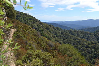
Castle Rock State Park is a 5,242-acre (2,121 ha) state park of California, United States, located along the crest of the Santa Cruz Mountains and almost entirely in Santa Cruz County, with parts extending into Santa Clara County and San Mateo County. It embraces coast redwood, Douglas fir, and madrone forest, most of which has been left in its wild, natural state. Steep canyons are sprinkled with unusual rock formations that are a popular rock climbing area. The park is named after a sandstone formation called Castle Rock. The forest here is lush and mossy, crisscrossed by 32 miles (51 km) of hiking trails. These trails are part of an even more extensive trail system that links the Santa Clara and San Lorenzo valleys with Castle Rock State Park, Big Basin Redwoods State Park, and the Pacific Coast. Due to its overnight parking lot, Castle Rock is a popular starting point for the Skyline-to-the-Sea Trail, a 30-mile (48 km) trail that begins near by at Saratoga Gap and leads to Waddell Beach north of Santa Cruz. There are two walk-in campgrounds within the park for overnight backpacking.
Castle Peak is the ninth highest summit of the Rocky Mountains of North America and the U.S. state of Colorado. The prominent 14,272-foot (4350.20 m) fourteener is the highest summit of the Elk Mountains and the Maroon Bells-Snowmass Wilderness. The peak is located 11.6 miles (18.7 km) northeast by north of the Town of Crested Butte, Colorado, United States, on the drainage divide separating Gunnison National Forest and Gunnison County from White River National Forest and Pitkin County. The summit of Castle Peak is the highest point of both counties.

A volcanic plug, also called a volcanic neck or lava neck, is a volcanic object created when magma hardens within a vent on an active volcano. When present, a plug can cause an extreme build-up of high gas pressure if rising volatile-charged magma is trapped beneath it, and this can sometimes lead to an explosive eruption. In a plinian eruption the plug is destroyed and ash is ejected.

Beacon Rock State Park is a geologic preserve and public recreation area on Route 14 in the Columbia River Gorge National Scenic Area in Skamania County, Washington, United States. The park takes its name from Beacon Rock, an 848-foot (258 m) basalt volcanic plug on the north shore of the Columbia River 32 miles (51 km) east of Vancouver. On October 31, 1805, the Lewis and Clark Expedition arrived here and first measured tides on the river, indicating that they were nearing the ocean.
The Wasatch Back is a region in the Rocky Mountains in northern Utah, United States. It includes cities such as Park City, Heber City, and Morgan. The name Wasatch Back differentiates it from the Wasatch Front, which includes Utah's more populous cities such as Salt Lake City, Ogden, Layton, and Provo. The Wasatch Back sits on the eastern side of the Wasatch Range of the Rocky Mountains, while the Wasatch Front sits on the western side. Wasatch is a Ute Indian word that means "mountain pass" or "low pass over high range." The Wasatch Back is a very affluent region. Summit County is one of the wealthiest counties in the United States.
Castle Mountain is a forested mountain ridge that lies along the Cacapon River south of its confluence with the North River at Forks of Cacapon in Hampshire County, West Virginia, United States. The mountain is named for the Caudy's Castle rock outcrop pillar that lies on its southern end overlooking the Cacapon River. Castle Run, which runs along its western flank into the North River, also takes its name from the outcrop. The ridge runs from southwest to northeast and can be viewed from the Bloomery Pike.

Garret Mountain Reservation is a 568-acre (230 ha) park located on First Watchung Mountain in Paterson and Woodland Park in southern Passaic County, New Jersey. In 1967, it was designated a National Natural Landmark as part of the Great Falls of Paterson-Garret Mountain listing. The park extends into Clifton. Garret Mountain is Passaic County's major recreational area, providing the visitors with grass fields, several miles of walking/running trails, basketball courts, picnic areas, Barbour's Pond is state stocked with fish for anglers, as well as an Equestrian Center with horseback riding lessons.

South Table Mountain is a mesa on the eastern flank of the Front Range of the Rocky Mountains of North America. Castle Rock, the 6,338-foot (1,932 m) summit of the mesa, is located on private property in Jefferson County, Colorado, 0.56 miles (0.9 km) directly east of downtown Golden.
Rock Castle is an unincorporated community in southwestern Jackson County, West Virginia, United States. It lies along Rock Castle Road, south of the city of Ripley, the county seat of Jackson County. Its elevation is 705 feet (215 m).

The Castle Crags Wilderness is a 12,232-acre (49.50 km2) wilderness area in the Castle Crags rock formations of the Trinity Mountains, and within the Shasta-Trinity National Forest, in northwestern California. It is located in Siskiyou County and Shasta County, 40 miles (64 km) north of Redding and south of Mount Shasta City.
The Castle Mountains, highest point Elk Peak, el. 8,589 feet (2,618 m), are an island range east of White Sulphur Springs in Meagher County, Montana, United States. About 30,000 acres of the Castles were roadless as of 1995. The western portion of the Castles are moist, while the eastside is dry, porous limestone hills. The range gets its name from "castle turrets", 50-foot high igneous rock spires on the western slopes. The range was the focus of mining activity in the previous century; crumbling remains of old miners' cabins and diggings are present throughout the area. The landscape is characterized by a central cluster of peaks over 8,000 feet and extensive grassy parks surrounded by lodgepole pine and limber pine. The Castles are lightly used by recreationists except for hunters in the fall. On the peak of Castle Mountain itself is a logbook for the few who reach the top. There is no trail that leads to the peak.
Castle Rock Glacier is in the U.S. state of Montana. The glacier is situated south of Castle Rock Mountain in the Beartooth Mountains. The glacier terminus is a proglacial lake and the glacier extends from 11,700 to 11,000 ft.
Sundance Glacier is in the U.S. state of Montana. The glacier is situated in the Beartooth Mountains at an elevation of 10,600 feet (3,200 m) above sea level and is immediately northeast of Castle Rock Mountain. The glacier covers approximately 70 acres (0.28 km2) and is located in a deep cirque below Castle Rock Mountain.

The Smoky Mountains are part of the Rocky Mountains and located on the west side of the Wood River Valley near Sun Valley, Idaho, in the Western United States. The range is within Sawtooth National Forest, while part of it is within the Sawtooth National Recreation Area. The highest point in the range is Saviers Peak at 10,441 ft (3,182 m).

The Front Range Urban Corridor is an oblong region of urban population located along the eastern face of the Southern Rocky Mountains, encompassing 18 counties in the US states of Colorado and Wyoming. The corridor derives its name from the Front Range, the mountain range that defines the western boundary of the corridor which serves as a gateway to the Rocky Mountains. The region comprises the northern portion of the Southern Rocky Mountain Front geographic area, which in turn comprises the southern portion of the Rocky Mountain Front geographic area of Canada and the United States. The Front Range Urban Corridor had a population of 5,055,344 at the 2020 census, an increase of +16.65% since the 2010 census.
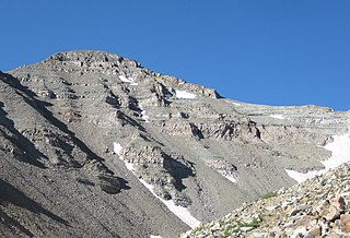
Castle Rock Mountain is in the Beartooth Mountains in the U.S. state of Montana. The peak is one of the tallest in the Beartooth Mountains, the tenth-tallest in Montana and is in the Absaroka-Beartooth Wilderness, on the border of Custer and Gallatin national forests. The nearest taller mountain to Castle Rock Mountain is Castle Rock Spire, 0.65 mi (1.05 km) east. Castle Rock Mountain is flanked by the Sundance Glacier to the north and the Castle Rock Glacier to the south.

