Inner Mongolia, officially the Inner Mongolia Autonomous Region (IMAR), is an autonomous region of the People's Republic of China. Its border includes most of the length of China's border with the country of Mongolia. Inner Mongolia also accounts for a small section of China's border with Russia. Its capital is Hohhot; other major cities include Baotou, Chifeng, Tongliao, and Ordos.

The Chahars are a subgroup of Mongols that speak Chakhar Mongolian and predominantly live in southeastern Inner Mongolia, China.
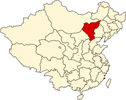
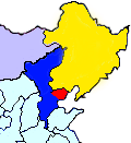
Mengjiang, also known as Mengkiang or the Mongol Border Land, officially referred to as the Mengjiang United Autonomous Government, was an autonomous area in Inner Mongolia, formed in 1939 as a puppet state of the Empire of Japan, then from 1940 being under the nominal sovereignty of the Reorganized National Government of the Republic of China. It consisted of the previously Chinese provinces of Chahar and Suiyuan, corresponding to the central part of modern Inner Mongolia. It has also been called Mongukuo or Mengguguo. The capital was Kalgan, from where it was under the nominal rule of Mongol nobleman Demchugdongrub. The territory returned to Chinese control after the defeat of the Japanese Empire in 1945.

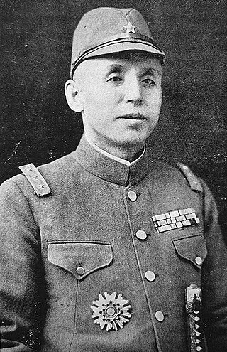
Demchugdongrub, also known as Prince De, courtesy name Xixian, was a Qing dynasty Mongol prince descended from the Borjigin imperial clan who lived during the 20th century and became the leader of an independence movement in Inner Mongolia. He was most notable for being the chairman of the pro-Japanese Mongol Military Government (1938–39) and later of the puppet state of Mengjiang (1939–45), during the Second Sino-Japanese War. In the modern day, some see Demchugdongrub as a Mongol nationalist promoting Pan-Mongolism, while others view him as a traitor and a pawn of the Japanese during World War II.
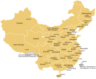
The provincial level administrative divisions are the highest-level administrative divisions of China. There are 34 such divisions claimed by the People's Republic of China, classified as 23 provinces, five autonomous regions, four municipalities and two special administrative regions. The political status of Taiwan Province along with a small fraction of Fujian Province remain in dispute; those are under separate rule by the Republic of China, which is usually referred to as "Taiwan".

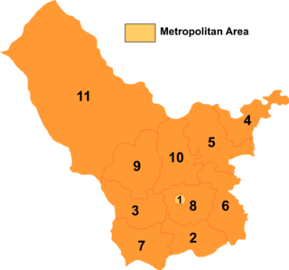
Hohhot, formerly known as Kweisui or Guisui, is the capital of Inner Mongolia in the north of the People's Republic of China, serving as the region's administrative, economic and cultural center. Its population was 3,446,100 inhabitants as of the 2020 census, of whom 2,944,889 lived in the metropolitan area consisting of 4 urban districts plus the Tümed Left Banner.

Zhangjiakou also known as Kalgan and by several other names, is a prefecture-level city in northwestern Hebei province in Northern China, bordering Beijing to the southeast, Inner Mongolia to the north and west, and Shanxi to the southwest. By 2019, its population was 4,650,000 inhabitants on 36,861.56 square kilometres (14,232.33 sq mi), divided into 17 Counties and Districts. The built-up area made of Qiaoxi, Qiaodong, Chongli, Xuanhua, Xiahuayuan Districts largely being conurbated had 1,500,000 inhabitants in 2019 on 1,412.7 km2 (545.4 sq mi).

Bortala is an autonomous prefecture for Mongol people in the northern middle of Xinjiang Uyghur Autonomous Region, Western China. It has an area of 27,000 km2 (10,000 sq mi). Bole is its capital. "Boro tala" comes from the Mongolian language and means "brown steppe".

Operation Chahar, known in Chinese as the Nankou Campaign, occurred in August 1937, following the Battle of Beiping-Tianjin at the beginning of Second Sino-Japanese War.
The Hebei–Chahar Political Council, or Hebei-Chahar Political Commission, was established at Beijing under Gen. Song Zheyuan, on 18th December 1935.
The Inner Mongolian campaign in the period from 1933 to 1936 were part of the ongoing invasion of northern China by the Empire of Japan prior to the official start of hostilities in the Second Sino-Japanese War. In 1931, the invasion of Manchuria secured the creation of the puppet state of Manchukuo and in 1933, Operation Nekka detached the province of Rehe from the Republic of China. Blocked from further advance south by the Tanggu Truce, the Imperial Japanese Army turned its attention west, towards the Inner Mongolian provinces of Chahar and Suiyuan, with the goal of establishing a northern China buffer state. In order to avoid overt violation of the Truce, the Japanese government used proxy armies in these campaigns while Chinese resistance was at first only provided by Anti-Japanese resistance movement forces in Chahar. The former included in the Inner Mongolian Army, the Manchukuo Imperial Army, and the Grand Han Righteous Army. Chinese government forces were overtly hostile to the anti-Japanese resistance and resisted Japanese aggression only in Suiyuan in 1936.
Erke Khongghor, alternatively known as Ejei, (?–1641) was the last khagan of the Northern Yuan dynasty, ruling briefly from 1634 to 1635. He was the son of Ligdan Khan. The Northern Yuan dynasty, which existed as remnants of the Yuan dynasty retreating north to the Mongolian Plateau after 1368, was defeated by the Later Jin dynasty in 1635 and thus formally came to an end.

Bayannur or Bayannao'er is a prefecture-level city in western Inner Mongolia, People's Republic of China. Until 1 December 2003, the area was called Bayannur League.
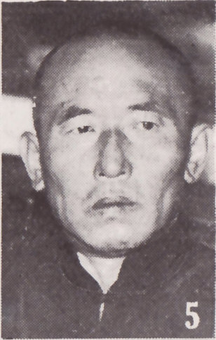
Li Shouxin was a pro-Japanese commander in the Manchukuo Imperial Army and later the Mengjiang National Army.
The Roman Catholic Diocese of Xiwanzi/Chongli is a diocese located in the city of Xiwanzi in the Ecclesiastical province of Suiyuan in China.
Chahar or Qahar Right Front Banner is a Banner of Inner Mongolia, People's Republic of China, surrounding Jining District and bordering Xinghe County to the east, Fengzhen City to the south, Zhuozi County to the west, and Chahar Right Back Banner to the north. Its territory includes Lake Huangqi. It is under the administration of Ulaan Chab City. Its most important settlement is Tuguiwula, where Tuguiwula railway station is located.
Chahar Right Middle Banner is a banner of Inner Mongolia, People's Republic of China, bordered by Chahar Right Back Banner to the east, Zhuozi County to the south, and Siziwang Banner to the northwest. It is under the administration of Ulaan Chab City.

Chahar Right Rear Banner is a banner of Inner Mongolia, People's Republic of China, bordering Shangdu County to the northeast, Xinghe County to the southeast, Qahar Right Front Banner to the south, Zhuozi County to the southwest, Qahar Right Rear Banner to the west, Dorbod Banner to the northwest, and Xilingol League to the north. It is under the administration of Ulanqab City, which lies to the south along the G55 Erenhot–Guangzhou Expressway. The most important settlement in the banner is Baiyinchagan.
Yu Pinqing was a politician and industrialist in the Republic of China. He was Supreme Member of the Southern Chahar Autonomous Government, later he was also appointed Vice-Chairman of the Mongolian United Autonomous Government and the Mongolian Autonomous Federation. He was born in Nangong, Zhili (Hebei).

The North Shanxi Autonomous Government was an administratively autonomous component of Mengjiang from its creation in 1937 to its complete merger into Mengjiang in 1939. Following the Japanese invasion of China in July 1937, regional governments were established in Japanese-occupied territories. After Operation Chahar in September 1937, which extended Japanese control to northern Shanxi region, more formal control of the area was established through the creation of the North Shanxi Autonomous Government, as well as the South Chahar Autonomous Government to the east of Shanxi.