Champlain Bridge (Montreal, 1962–2019)

Last updated

Champlain Bridge

Pont Champlain (French)
Pont Champlain - 2010-10.jpg
Champlain Bridge in October 2010
Coordinates 45°28′07″N73°31′03″W / 45.46861°N 73.51750°W / 45.46861; -73.51750
CarriedSix lanes of Autoroute 10, 15, 20
Crossed St. Lawrence River and
Saint Lawrence Seaway
Locale Brossard and Montreal, Quebec, Canada
OwnerThe Jacques Cartier and Champlain Bridges Inc.
Maintained byThe Jacques Cartier and Champlain Bridges Inc.
Website jacquescartierchamplain.ca?lang=en
Characteristics
DesignSteel truss Cantilever bridge
Material Steel, Concrete
Total length3,440 m (11,286 ft)
7,412 m (24,318 ft) (including approaches) [1]
Longest span215.5 m (707.02 ft) [1]
Clearance below 36.6 m (120 ft) at mid-span [1]
No. of lanes 6
History
Designer Philip Louis Pratley
Henry Hugh Lewis Pratley
Engineering design byPhilippe Ewart
Lalonde and Valois
Constructed byAtlas Construction Company Limited
McNamara (Quebec) Limited
The Key Construction Inc.
Deschamps & Bélanger Limitée
Dominion Bridge Company
Construction start1957
Construction cost C$35 million
C$52 million (including approaches and Bonaventure Expressway)
OpenedJune 28, 1962 (1962-06-28)
ClosedJune 28, 2019 (2019-06-28)
Demolishedc. 2024
Statistics
Daily traffic 159,000 [2]
TollCollected until 1990
Location
Champlain Bridge (Montreal, 1962-2019)

The Champlain Bridge (French : Pont Champlain) was a steel truss cantilever bridge with approach viaducts constructed of prestressed concrete beams supporting a prestressed concrete deck paved with asphalt. Opened in 1962, the bridge crossed the Saint Lawrence River, connecting the Island of Montreal to its South Shore suburbs. [3]

Contents

Together with the Jacques Cartier Bridge, it was administered by the Jacques Cartier and Champlain Bridges Incorporated (JCCBI), a Canadian Crown Corporation which reports to Housing, Infrastructure and Communities Canada. Since December 21, 1978, JCCBI was responsible for the management, maintenance and monitoring of the Champlain Bridge. [4]

The bridge saw about 50 million crossings per year, of which 200,000 were buses. On an average weekday, 66% of users were commuters. It was one of the busiest bridges in Canada until its closure in 2019. [5]

Towards the end of its life, the Champlain Bridge was well known to be in an advanced state of decay. Long-discussed plans to construct a new Bridge finally came to fruition when construction commenced in 2015. Upon the opening of the new span in 2019, the original Champlain Bridge was closed and promptly demolished, concluding 57 years of service. [3] [6] [7]

Specifications

The Champlain Bridge project was undertaken in 1955 and construction proceeded between 1957 and 1962. The bridge carried six lanes of vehicle traffic; three in each direction. During rush hour one lane of those heading off the island in the morning, and onto the island in the evening, was used as a reserved bus lane for buses to be able to head in the opposite direction. The bridge was opened to traffic in stages as the approaches were completed between June 1962 and September 1964. It was subsequently connected to the Bonaventure Expressway, which was part of the north approach to the bridge. The expressway was opened to traffic on April 21, 1967. It was one of North America's busiest highways with almost 59 million crossings annually.

Just upstream from the bridge there is an ice boom, the Champlain Bridge Ice Control Structure. [8]

Construction history

View from the east side of the Saint Lawrence River, July 2011 Champlain Bridge Montreal.jpg
View from the east side of the Saint Lawrence River, July 2011
The upstream ice control structure Champlain Bridge over Saint Lawrence.JPG
The upstream ice control structure

On August 17, 1955, Federal Transport Minister George Marler announced the planned construction of a new bridge connecting Montreal to the South Shore via Nun's Island. The city's existing bridges (Victoria, Cartier, and Mercier) had become inadequate to support the amount of traffic that carried residents from the growing South Shore suburbs into Montreal.

The project was initially called the Nuns' Island Bridge because it crosses Nuns' Island. In 1958, it was named the Champlain Bridge in honour of the explorer Samuel de Champlain.

The National Harbours Board was placed in charge of the project. Through several lengthy meetings and consultations in the fall of 1955, the location for the bridge and its approaches were selected. Originally, the plan had been to build the bridge with only 4 lanes, with room for further expansion to 6 lanes. During the design phase, however, it was decided to go with an initial 6-lane design.

It was opened on June 28, 1962 at 4 p.m. with only one approach from Montreal, via Wellington Street. A section including approaches to and from Atwater Street and La Vérendrye Boulevard were opened two years later.

In 1967, the final approach to the bridge on the Montréal side was completed when the Bonaventure Expressway was opened to traffic. [9]

A $0.25 toll ($0.08 if paid with tokens) was charged to finance the $35 million cost of the Champlain Bridge. The toll was collected until 1990, when the Jacques Cartier and Champlain Bridges Incorporated (JCCBI), which took over jurisdiction of the bridge a dozen years earlier, removed the toll plaza. [10]

In 1992, the concrete deck of the cantilever metal part was replaced by an orthotropic steel deck. Gutters to channel the corrosive runoff to the river appeared in 1994. The pressure exerted by the reinforced beams on the ends of the trimmers then required the reinforcement of the latter by steel rods under tension.

In November 2013, a crack was discovered in a critical part of the superstructure. One lane was closed immediately, and emergency repair plans were put in place. During preparation, the crack enlarged and a second lane was closed. [11] On November 29, 2013, a temporary external beam of 75 tons, named "super-beam" by the media, was urgently installed to reinforce the structure. In June 2014, JCCBI replaced the super-beam with a modular truss that was designed and manufactured in Quebec.

As part of a 2014–2017 Edge girder reinforcement program, 94 modular trusses and six shoring systems were installed to stabilize the condition of the bridge girders. [3]

Problems and replacement

Montreal's climate subjected the Champlain Bridge to wintry cold, snowfall, and windy conditions, as well as contrasting hot and humid summer conditions, all of which accelerated damage to the bridge. Because of the potential danger from ice accumulation during winter, the bridge was salted every season for decades. Salt attacks both the concrete and steel rebar used in girders, pylons, and other parts. The problems associated with the design and maintenance of the Champlain Bridge thus exceeded the useful life of several structural components. The design and construction of the structure prevented the isolation of outdated elements and their replacement with new ones, as could be done on other structures. Given the advanced deterioration of the bridge, it was constantly monitored by 300 sensors.

Several reinforcement measures and rehabilitation programs were deployed over time by JCCBI. However, none of these were effective in the long term.

In 2009, the Government of Canada announced in its 2009 Economic Action Plan that it would be allocating $212 million to renew the bridge. In March 2011, the Government of Canada announced $158 million were to be spent on a major repair and maintenance program as concerns mounted that it was at risk of collapse. Montreal's La Presse newspaper cited two leaked engineering reports prepared for a federal bridge agency that suggested sections of the structure were in a severe state of deterioration. The report concluded that a partial or complete collapse of the span could not be ruled out. [12]

Starting in 2009, JCCBI — the Federal agency that managed the structure — began conducting a major repair program to extend the useful life of the Champlain Bridge. In 2010, JCCBI retained international engineering firm Delcan to carry out an expert study of the bridge's structural health. The firm returned a report entitled "The Future of the Champlain Bridge Crossing". In the Executive Summary, the bridge was said to be "functionally deficient" for both current and long-term traffic demands, and showing "significant deterioration". [13] One finding suggested that the Champlain Bridge was in "very much poorer condition than would be typical" for comparable bridges. Delcan concluded that the bridge had "many deficiencies" and, even in light of the methodical inspection and rehabilitation of the structure undertaken by its owners, that continued operation "entails some risks that cannot altogether be quantified".

In September 2007, faced with rising costs for the maintenance of the Champlain Bridge, then Canadian Minister of Transport Lawrence Cannon confirmed that his department was seriously considering the construction of a replacement structure. In August 2008, Transport Canada announced that it was exploring different scenarios for a new bridge. In October 2011, then Minister of Transport Denis Lebel officially announced that construction on the new bridge would begin within 10 years.

In April 2015, the federal government selected the JV consortium: Signature on the St. Lawrence Group to build the new bridge. The consortium mainly included SNC-Lavalin, the Spanish ACS Infrastructure, and Dragados Canada. T.Y. Lin International served as the Lead Designer. [14]

Construction on the new bridge officially began on June 16, 2015. On December 19, 2018, Minister of Infrastructure and Communities François-Philippe Champagne announced that the official name of the new bridge would be the Samuel-de-Champlain Bridge. [15] The bridge opened to northbound/westbound traffic on June 24, 2019 (St-Jean-Baptiste Day), with the official opening ceremony being held on June 28, 2019, and southbound/eastbound traffic opening on 1 July 2019 (Canada Day). The multi-purpose runway was opened in November 2019 followed by the REM train tracks on July 31, 2023. [16] [17]

As soon as the new bridge was opened to traffic, the old bridge was closed and demolition work began immediately.

The cable-stayed Samuel de Champlain bridge (background) illuminated at night, with the old truss cantilever bridge (foreground) being dismantled, May 2022. Brossard (Quebec)-Pont Samuel de Champlain illumine-2022-05-17.jpg
The cable-stayed Samuel de Champlain bridge (background) illuminated at night, with the old truss cantilever bridge (foreground) being dismantled, May 2022.

See also

Related Research Articles

<span class="mw-page-title-main">Island of Montreal</span> Island in Quebec, Canada

The Island of Montreal is a large island in southwestern Quebec, Canada, that is the site of a number of municipalities, including most of the city of Montreal, and is the most populous island in Canada. It is the main island of the Hochelaga Archipelago at the confluence of the Saint Lawrence and Ottawa rivers.

King's Highway 401, commonly referred to as Highway 401 and also known by its official name as the Macdonald–Cartier Freeway or colloquially referred to as the four-oh-one, is a controlled-access 400-series highway in the Canadian province of Ontario. It stretches 828 kilometres (514 mi) from Windsor in the west to the Ontario–Quebec border in the east. The part of Highway 401 that passes through Toronto is North America's busiest highway, and one of the widest. Together with Quebec Autoroute 20, it forms the road transportation backbone of the Quebec City–Windsor Corridor, along which over half of Canada's population resides. It is also a Core Route in the National Highway System of Canada. The route is maintained by the Ministry of Transportation of Ontario (MTO) and patrolled by the Ontario Provincial Police. The speed limit is 100 km/h (62 mph) throughout its length, with the only exceptions being the posted 80 km/h (50 mph) limit westbound in Windsor and in most construction zones, along with a 110 km/h (68 mph) speed limit between Windsor and Tilbury.

<span class="mw-page-title-main">Gladesville Bridge</span> Bridge in Sydney, Australia

Gladesville Bridge is a heritage-listed concrete arch road bridge that carries Victoria Road over the Parramatta River, linking the Sydney suburbs of Huntleys Point and Drummoyne, in the local government areas of Canada Bay and Hunter's Hill, in New South Wales, Australia. Despite its name, the bridge is not in Gladesville.

<span class="mw-page-title-main">Victoria Bridge (Montreal)</span> Bridge over the St. Lawrence River in Montreal, Quebec

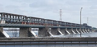
The Victoria Bridge, previously known as Victoria Jubilee Bridge, is a bridge over the St. Lawrence River, linking Montreal, Quebec, to the south shore city of Saint-Lambert.

<span class="mw-page-title-main">Blue Water Bridge</span> Twin-span bridge between Point Edward, Ontario, Canada and Port Huron, Michigan, US

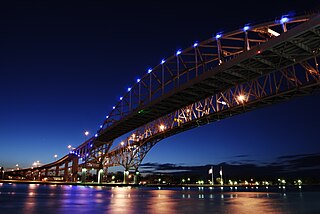
The Blue Water Bridge is a twin-span international bridge across the St. Clair River that links Port Huron, Michigan, United States, and Point Edward, Ontario, Canada. The Blue Water Bridge connects Highway 402 in Ontario with both Interstate 69 (I-69) and Interstate 94 (I-94) in Michigan.

<span class="mw-page-title-main">Jacques Cartier Bridge</span> Bridge near Montreal, Quebec, Canada

The Jacques Cartier Bridge is a steel truss cantilever bridge crossing the Saint Lawrence River from Montreal Island, Montreal, Quebec, to the south shore at Longueuil, Quebec, Canada. The bridge crosses Saint Helen's Island in the centre of the river, where offramps allow access to the Parc Jean-Drapeau and La Ronde amusement park.

<span class="mw-page-title-main">Taschereau Boulevard</span> Thoroughfare on Montreals south shore

Taschereau Boulevard is a major suburban boulevard located on the south shore of Montreal, Quebec, Canada. It is a section of Quebec Route 134 and runs from Longueuil to Candiac. It is named after the prominent Quebec family, which included former Premier Louis-Alexandre Taschereau. At 17.5 km (10.9 mi), it is one of the longest commercial arteries in Canada. It serves the heart of an area with an estimated population of 400,000.

Autoroute 15 is a highway in western Quebec, Canada. It was, until the extension of Autoroute 25 was opened in 2011, the only constructed north-south autoroute to go out of Montreal on both sides. A-15 begins at the end of Interstate 87 at the United States border at Saint-Bernard-de-Lacolle and extends via Montreal to Sainte-Agathe-des-Monts with an eventual continuation beyond Mont-Tremblant. The total length of A-15 is currently 164 km (101.9 mi), including a short concurrency with Autoroute 40 that connects the two main sections. This is one of the few autoroutes in Quebec that does not have any spinoff highways.

Autoroute 10 (A-10) is an Autoroute of Quebec in Canada that links greater Montreal to key population centres in Montérégie and Estrie, including Brossard, Saint-Jean-sur-Richelieu, Granby, and Sherbrooke.

<span class="mw-page-title-main">Quebec Route 136 (Montreal)</span> Highway in Montreal, Quebec

Route 136 (R-136), formerly Autoroute 720, known as the Ville-Marie Expressway (English) or Autoroute Ville-Marie (French) is an Autoroute highway in the Canadian province of Quebec that is a spur route of Autoroute 20 in Montreal. Its western terminus is located at the Turcot Interchange, a junction with Autoroute 15 and Autoroute 20, and its eastern terminus is near the Jacques Cartier Bridge, where the highway merges with Notre-Dame Street. The Autoroute Ville-Marie designation is named after the downtown borough of Ville-Marie, through which the expressway is routed. It was designated Autoroute 720 until 2021 when it was renamed to Route 136.

<span class="mw-page-title-main">Honoré Mercier Bridge</span> Bridge in Kahnawake and Montreal, Quebec

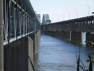
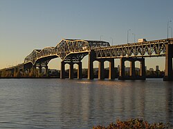
The Honoré Mercier Bridge in Quebec, Canada, connects the Montreal borough of LaSalle on the Island of Montreal with the Mohawk reserve of Kahnawake and the suburb of Châteauguay on the south shore of the Saint Lawrence River. It is the most direct southerly route from the island of Montreal toward the US border. It carries Route 138, originally Route 4. It is 1.361 km (0.846 mi) in length and contains four steel trusses on its first section. The height of the bridge varies from 12.44 m (40.8 ft) to 33.38 m (109.5 ft) with the highest sections located over the St. Lawrence Seaway. The bridge is named after former premier of Quebec Honoré Mercier.

Mahatma Gandhi Setu is a bridge over the river Ganges in Bihar, India, connecting Patna in the south to Hajipur in the north. Its length is 5,750 metres (18,860 ft) and it is the fourth-longest river bridge in India. It was inaugurated in May 1982 in a ceremony in Hajipur by the then prime minister, Indira Gandhi. From 1982 to 2017, Mahatma Gandhi Setu remained as the longest bridge in India. Later, Gandhi Setu rehabilitation project was undertaken to install triangular steel trusses on Mahatma Gandhi Setu.

<span class="mw-page-title-main">Quebec Autoroute 19</span> Highway in Quebec

Autoroute 19, also known as Autoroute Papineau, is an autoroute in Quebec. It crosses the Rivière des Prairies via the Papineau-Leblanc Bridge, connecting the borough of Ahuntsic-Cartierville in Montreal and the Duvernay neighbourhood in Laval.

<span class="mw-page-title-main">Roseville Bridge</span> Bridge in New South Wales, Australia

The Roseville Bridge, is a pre-stressed concrete box girder road bridge that carries Warringah Road, part of the A38 across Middle Harbour, located adjacent to the suburb of Roseville, in Sydney, New South Wales, Australia. The bridge is one of two crossings of Middle Harbour, the other being the Spit Bridge.

<span class="mw-page-title-main">Olivier-Charbonneau Bridge</span> Bridge in between Laval , and Montreal

The Olivier Charbonneau Bridge is a toll bridge over the Rivière des Prairies, between Laval's St. François district and Montreal's Rivière-des-Prairies–Pointe-aux-Trembles borough. Along with the Serge-Marcil Bridge, it is one of two toll bridges in Quebec.

<span class="mw-page-title-main">North–South Motorway</span> Motorway in Adelaide, South Australia

The North–South Motorway is a partially complete motorway traversing the inner western suburbs of Adelaide, from Waterloo Corner in the north to Bedford Park in the south. Progressively constructed in stages since 2010, once complete it will replace the adjacent South Road as Adelaide's main north–south roadway. It will form the central section of the North–South Corridor, being flanked north and south by the Northern Expressway and Southern Expressway, respectively. It is designated part of route M2.

The Melocheville Tunnel is a tunnel connecting Beauharnois and Melocheville in Quebec, Canada. It is a segment of Route 132 located near the Beauharnois generating station. The tunnel measures 227.6 m (747 ft) m. Until 1991, it was called the Beauharnois Tunnel.

<span class="mw-page-title-main">Samuel-De Champlain Bridge</span> Bridge over the Saint Lawrence River in Montreal, Canada

The Samuel-De Champlain Bridge, colloquially known as the Champlain Bridge, is a cable-stayed bridge design by architect Poul Ove Jensen and built to replace the original Champlain Bridge over the Saint Lawrence River in Quebec, between Nuns' Island in the borough of Verdun in Montreal and the suburban city of Brossard on the South Shore. A second, connected bridge links Nuns' Island to the main Island of Montreal. It is the busiest bridge in the country with more cars flowing into it than any other bridge.

References

  1. 1 2 3 "Champlain Bridge: Technical Data". Bridges & Structures. The Jacques Cartier and Champlain Bridges Incorporated. Archived from the original on December 11, 2013. Retrieved December 6, 2013.
  2. Sources disagree on the actual figure:
  3. 1 2 3 "Original Champlain Bridge ⋆ PJCCI". PJCCI. Retrieved March 12, 2018.
  4. "About ⋆ PJCCI". PJCCI. Retrieved March 12, 2018.
  5. "New Champlain Bridge - Frequently Asked Questions". Infrastructure Canada. February 21, 2012. Retrieved August 26, 2016.
  6. "Montreal's Samuel De Champlain Bridge is now open | CBC News".
  7. "Demolition of old Champlain Bridge to cost $400". CBC. April 5, 2017.
  8. "Technical Data Sheet - Champlain Bridge Sector" (PDF). PJCCI.com. Archived from the original (PDF) on June 26, 2017.
  9. "The Champlain Bridge and the Bonaventure Expressway" (PDF). Archived from the original (PDF) on June 25, 2008. Retrieved July 1, 2008.
  10. "The Champlain Bridge:Historic overview" . Retrieved April 29, 2009.
  11. "Champlain Bridge: The Support Beam operation is underway - two lanes per direction during the next few days - Pont Champlain Bridge". Archived from the original on December 2, 2013. Retrieved November 24, 2013.
  12. "Montreal bridge gets $158M in repair funds". CBC News. March 18, 2011. Retrieved March 18, 2011.
  13. Delcan, Inc (March 28, 2011). "Future of the Champlain Bridge Crossing" (PDF). pjcci.ca. Archived from the original (PDF) on July 23, 2011. Retrieved April 11, 2011.
  14. "New Champlain Bridge Corridor Project". Road-Traffic Technology.com. Retrieved November 8, 2017.
  15. Magder, Jason (December 19, 2019). "The new Champlain Bridge is finished — mostly". Montreal Gazette. Retrieved July 7, 2019.
  16. "Work schedule 2021". REM. Retrieved November 22, 2021.
  17. Nerestant, Antoni (July 31, 2023). "Stuck railway switch on Montreal's new REM to blame for bumpy start to 1st official day". CBC News. Retrieved July 31, 2023.

Commons-logo.svg Media related to Champlain bridge at Wikimedia Commons