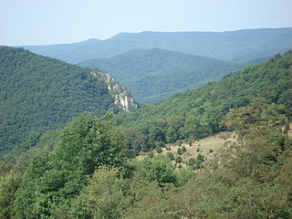
Kittatinny Mountain is a long ridge traversing across northwestern New Jersey running in a northeast-southwest axis, a continuation across the Delaware Water Gap of Pennsylvania's Blue Mountain Ridge. It is the first major ridge in the far northeastern extension of the Ridge and Valley province of the Appalachian Mountains, and reaches its highest elevation, 1,803 feet, at High Point in Montague Township. Kittatinny Mountain forms the eastern side of Wallpack Valley; the western side comprises the Wallpack Ridge (highest elevation: 928 feet above sea level.

Short Hill Mountain is a mountain ridge of the Blue Ridge Mountains in northwest Loudoun County, Virginia.
The Cherry Creek School District 5, also known as Cherry Creek Public Schools, is a school district based in western Arapahoe County, Colorado. The superintendent is Scott Siegfried. It consists of elementary, middle, and high schools. The district headquarters are in Greenwood Village.

Martin Hill is a mountain ridge which connects Tussey Mountain to its east and Evitts Mountain to its west. Martin Hill is located in the Martin Hill Wild Area, which is a part of the Buchanan State Forest, in Bedford County, Pennsylvania. The summit of Martin Hill is one of the few in the Commonwealth which is void of any towers or transmitters; such equipment is located instead on a lesser nearby summit in the same mountain complex. Martin Hill is the second highest in Pennsylvania's Ridge and Valley Appalachians, the highest being Wills Mountain to its west at 2,780 ft (850 m). The highest mountains in the Commonwealth are located in the Allegheny Mountains in western Pennsylvania, where Mount Davis stands at 3,213 ft (979 m).

The Chuckanut Mountains, or Chuckanuts, are located on the northern Washington state coast of the Salish Sea, just south of Bellingham, Washington. Being a part of the Cascade Range, they are the only place where the Cascades come west down to meet the sea. The Chuckanuts are considered to be a part of the Puget Lowland Forest Ecoregion.
Saltonstall Mountain, also known as Saltonstall Ridge, with a high point of (est.) 320 feet (98 m) above sea level, is a traprock mountain ridge located 3 miles (5 km) east of New Haven, Connecticut and 1.75 miles (2.8 km) north of Long Island Sound. It is part of the Metacomet Ridge that extends from Long Island Sound near New Haven, Connecticut, north through the Connecticut River Valley of Massachusetts to the Vermont border. Saltonstall Mountain is known for its 100 foot (30 m) scenic cliff faces and sharp ridgeline, unique microclimate ecosystems, rare plant communities, and for Lake Saltonstall, a 3 miles (5 km) long by 0.3 miles (400 m) wide municipal reservoir nearly enclosed by the mountain. Saltonstall Mountain is traversed by a number of hiking trails managed by the South Central Connecticut Regional Water Authority (SCCRWA) and Branford Land Trust.
White Rock, 2,550 feet (780 m), is the high point on a 7 mi (11 km) ridgeline in the Taconic Mountains. The ridge is located in the tri-state corner of New York, Massachusetts, and Vermont in the towns of Petersburgh, Williamstown, and Pownal. The ridge has several distinct knobs; those with names are, from south to north: White Rocks, 2,365 feet (721 m); Smith Hill, 2,330 feet (710 m); White Rock, the high point 2,550 feet (780 m); and Bald Mountain 2,485 feet (757 m). The Snow Hole, located along the ridgeline between Bald Mountain and the White Rock, is a crevasse in which snow can be found well into the summer.

Laurel Hill, also known as Laurel Ridge or Laurel Mountain, is a 70-mile-long (110 km) mountain in Pennsylvania's Allegheny Mountains. This ridge is flanked by Negro Mountain to its east and Chestnut Ridge to its west. The mountain is home to six state parks: Laurel Ridge State Park, Laurel Mountain State Park, Linn Run State Park, Kooser State Park, Laurel Hill State Park, and Ohiopyle State Park. The 70-mile-long (110 km) Laurel Highlands Hiking Trail runs the length of the ridge.

Spruce Mountain, in eastern West Virginia, USA, is the highest ridge of the Allegheny Mountains. The "whale-backed" ridge extends for only about 16 miles (26 km), from northeast to southwest, but several of its peaks exceed 4,500 feet (1,400 m) in elevation. The summit, Spruce Knob, is celebrated as the highest point in the state as well as the range, which covers parts of four states.

Cherry Hill is an unincorporated community, located at the corner of Cherry Hill and Ridge Roads in Canton Township, in Wayne County, Michigan. The Cherry Hill Historic District is a primarily residential historic district encompassing the greater part of Cherry Hill. It was listed on the National Register of Historic Places in 2003.

The Marlboro Mountains, sometimes Marlborough Mountains, are a group of hogbacked mountains arranged in a 25-mile-long (40 km) ridge extending from Newburgh, New York to just south of Kingston, New York. Considered to be part of the Ridge and Valley Appalachians, the mountains, which reach elevations over 1,100 feet, form an imposing geologic barrier just west of the Hudson River. They subdivide the relatively flat Hudson River Valley to create the Wallkill Valley further west. Rising abruptly on their eastern flanks, the Marlboro Mountains are known for their sweeping views of the region.

Cherry Peak is a ski area in northern Utah that opened in 2014 and first used for skiing in the 2015–2016 season. It is located in Cherry Canyon, east of Richmond, Utah in the Bear River Mountains. While smaller and less developed than a number of Utah ski resorts, Cherry Peak is close and convenient to residents of nearby Logan, Utah State University, and Cache Valley. It also hosts students from more distant universities.

Red Ridge Hill is a mountain located in Central New York region of New York southwest of Milford, New York.

Morton Hill is a mountain located in the Catskill Mountains of New York north of Roscoe. Rodgers Hill is located southeast of Morton Hill and Cherry Ridge is located northwest.

Cherry Ridge is a ridge located in the Catskill Mountains of New York northwest of Roscoe. Morton Hill is located southeast of Cherry Ridge and Fuller Hill is located west-northwest.

Big Fork Mountain is a mountain located in the Catskill Mountains of New York southwest of Gregorytown. Stearns Hill is the variant name. Elm Tree Ridge is located west-northwest, Jehu Mountain is located west-northwest, and Cherry Ridge is located south of Big Fork Mountain.

Van Loan Hill is a mountain in Greene County, New York. It is located in the Catskill Mountains southwest of Maplecrest. Round Hill is located west, Elm Ridge is located north-northeast, and East Jewett Range is located south of Van Loan Hill.

Sam Miller Hill is a mountain in Sullivan County, New York. It is located northeast of Long Eddy. Cherry Ridge is located west and Hawks Nest is located southwest of Sam Miller Hill.

Hawks Nest is a mountain in Sullivan County, New York. It is located northeast of Long Eddy. Cherry Ridge is located north-northwest and Sam Miller Hill is located northeast of Hawks Nest.


