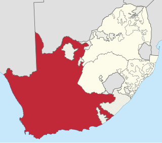
The Province of the Cape of Good Hope, commonly referred to as the Cape Province and colloquially as The Cape, was a province in the Union of South Africa and subsequently the Republic of South Africa. It encompassed the old Cape Colony, as well as Walvis Bay, and had Cape Town as its capital. In 1994, the Cape Province was divided into the new Eastern Cape, Northern Cape and Western Cape provinces, along with part of the North West.
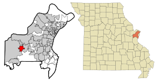
Ellisville is a city in St. Louis County, Missouri, United States within Greater St. Louis. It is a western outer-ring suburb of St. Louis. The population was 9,985 at the 2020 census.
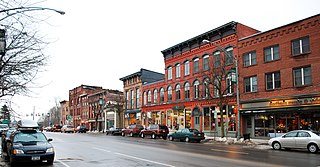
Potsdam is a village located in the Town of Potsdam in St. Lawrence County, New York, United States. The population was 8,312 at the 2020 census. The Village of Potsdam is in the eastern part of the town and is northeast of Canton, the county seat. The village is the locale of the State University of New York at Potsdam and Clarkson University.

Thomas Clarkson was an English abolitionist, and a leading campaigner against the slave trade in the British Empire. He helped found The Society for Effecting the Abolition of the Slave Trade and helped achieve passage of the Slave Trade Act 1807, which ended British trade in slaves.

The City of Wanneroo is a local government area with city status in the northern suburbs of Perth, Western Australia. It is centred approximately 25 kilometres (15.5 mi) north of Perth's central business district and forms part of the northern boundary of the Perth metropolitan area. Wangara encompasses the federal divisions of Cowan, Moore and Pearce.
The R330 is a Regional Route in South Africa that connects Cape St. Francis on the south coast with Hankey to the north via Humansdorp.
The R332 is a Regional Route in South Africa that connects Willowmore with the R330 and the N2 near Humansdorp.

The R402 is a Regional Route in South Africa that connects the N2 between Stormsrivier and Humansdorp with the R62 between Humansdorp and Joubertina.
Humansdorp is a small town and surrounding district in the Eastern Cape of South Africa, with a population of around 29,000 during the census of 2011. It is part of the Kouga Local Municipality of the Sarah Baartman District.
The Langkloof is a 160 km long valley in South Africa, lying between Herold, a small village northeast of George, and The Heights - just beyond Twee Riviere.
Thyspunt is a rocky stretch of coast approximately 12 km WNW of Cape Saint Francis in the Eastern Cape province of South Africa. It is just west of the beach Thysbaai and south-east of Oyster Bay. The point is near the popular surfing beach of Jeffreys Bay as well as the holiday town of St Francis Bay. It lies about 18 km SSW of the town of Humansdorp.

The Kouga Dam is an arch dam on the Kouga River about 21 km (13 mi) west of Patensie in Kouga Local Municipality, South Africa. It supplies irrigation water to the Kouga and Gamtoos valleys as well as drinking water to the Port Elizabeth metropolitan area via the Loerie Balancing Dam. It was constructed between 1957 and 1969.

The Bolus Herbarium was established in 1865 from a donation by Harry Bolus of his extensive herbarium and library to the South African College, which later became the University of Cape Town.

The R62 is a provincial route in South Africa that connects Ashton with Humansdorp. The R62 runs through the Little Karoo and the Langkloof, passing through Montagu, Ladismith, Calitzdorp, Oudtshoorn, and Joubertina.

The Kouga Local Municipality is located in the Eastern Cape of South Africa, approximately 80 km west of Port Elizabeth, and forms part of the Sarah Baartman District Municipality. Its territory includes the coastal zone between the Van Stadens River in the east and the Tsitsikamma River in the west, and stretches inland towards the Baviaanskloof Mountains in the north.
Kruisfontein is a suburb of Humansdorp in the Eastern Cape of South Africa with about 15,000 inhabitants.

Krom River or Kromme River is a river in the Eastern Cape Province in South Africa. The river flows into the Indian Ocean through an estuary on the north side of St Francis Bay, west of Port Elizabeth. The Krom river flows in an ESE direction and is approximately 109 km long with a catchment area of 1,085 km2.

Eastern Province Command was a command of the South African Army.
Humansdorp Commando was a light infantry regiment of the South African Army. It formed part of the South African Army Infantry Formation as well as the South African Territorial Reserve.

Paul Oliver Sauer was a South African Cabinet Minister and lifelong member of the National Party.


