Clymer, Pennsylvania

Last updated

Clymer, Pennsylvania
Borough
Sixth from Wolcott, Clymer.jpg
Sixth Street, looking northwest from Wolcott Street
Indiana County Pennsylvania Incorporated and Unincorporated areas Clymer Highlighted.svg
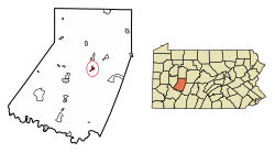
Location of Clymer in Indiana County, Pennsylvania.
USA Pennsylvania location map.svg
Red pog.svg
Clymer
Usa edcp location map.svg
Red pog.svg
Clymer
Coordinates: 40°40′08″N79°00′43″W / 40.66889°N 79.01194°W / 40.66889; -79.01194
Country United States
State Pennsylvania
County Indiana
Settled1905
Incorporated1908
Government
  TypeBorough Council
  MayorDennis Clawson
Area
[1]
  Total
0.59 sq mi (1.52 km2)
  Land0.57 sq mi (1.47 km2)
  Water0.02 sq mi (0.05 km2)
Population
 (2020) [2]
  Total
1,321
  Density2,321.62/sq mi (895.97/km2)
Time zone UTC-5 (Eastern (EST))
  Summer (DST) UTC-4 (EDT)
Zip code
15728
Area code 724
FIPS code 42-14520
Website clymerpa.com

Clymer is a borough in Indiana County, Pennsylvania, United States. The population was 1,336 at the 2020 census. [3] The community was named after William Bingham Clymer, grandson of George Clymer, one of the signers of the United States Declaration of Independence. William Clymer sold the land the borough is situated on to Thomas White (Namesake of White Township) in the 1830s. Most of Clymer's family died in a tragic sea accident in 1878, which made national news and inspired the name. It is surrounded by but separate from Cherryhill Township.

Contents

Geography

Clymer is located at 40°40′8″N79°0′43″W / 40.66889°N 79.01194°W / 40.66889; -79.01194 (40.668977, -79.011925). [4]

According to the United States Census Bureau, the borough has a total area of 0.6 square miles (1.6 km2), all land.

History

On 26 August 1926, forty-four people were killed in a coal mine explosion in Clymer. [5]

Demographics

Historical population
CensusPop.Note
1910 1,753
1920 2,86763.5%
1930 2,672−6.8%
1940 3,06214.6%
1950 2,500−18.4%
1960 2,251−10.0%
1970 2,054−8.8%
1980 1,761−14.3%
1990 1,499−14.9%
2000 1,5473.2%
2010 1,357−12.3%
2020 1,336−1.5%
2021 (est.)1,330 [3] −0.4%
Sources: [6] [7] [8] [9] [2]

At the 2000 census there were 1,547 people in 679 households, including 418 families, in the borough. The population density was 2,606.6 inhabitants per square mile (1,006.4/km2). There were 734 housing units at an average density of 1,236.8 per square mile (477.5/km2). The racial makeup of the borough was 99.55% White, 0.19% Native American, 0.06% Asian, 0.06% from other races, and 0.13% from two or more races. Hispanic or Latino of any race were 0.19%. [7]

There were 679 households, 27.0% had children under the age of 18 living with them, 44.9% were married couples living together, 12.5% had a female householder with no husband present, and 38.3% were non-families. 35.1% of households were made up of individuals, and 21.6% were one person aged 65 or older. The average household size was 2.28 and the average family size was 2.97.

The age distribution was 22.9% under the age of 18, 7.4% from 18 to 24, 27.1% from 25 to 44, 21.6% from 45 to 64, and 20.9% 65 or older. The median age was 39 years. For every 100 females there were 81.6 males. For every 100 females age 18 and over, there were 76.3 males.

The median household income was $24,688 and the median family income was $36,688. Males had a median income of $29,375 versus $25,000 for females. The per capita income for the borough was $14,250. About 14.5% of families and 16.5% of the population were below the poverty line, including 21.6% of those under age 18 and 15.9% of those age 65 or over.

Related Research Articles

<span class="mw-page-title-main">Liberty, Allegheny County, Pennsylvania</span> Borough in Pennsylvania, United States

Liberty is a borough in Allegheny County, Pennsylvania, United States. The population was 2,355 at the 2020 census.

<span class="mw-page-title-main">Atwood, Pennsylvania</span> Borough in Pennsylvania, United States

Atwood is a borough in Armstrong County, Pennsylvania, United States. The population was 112 at the 2020 census.

<span class="mw-page-title-main">Elderton, Pennsylvania</span> Borough in Pennsylvania, United States

Elderton is a borough in Armstrong County, Pennsylvania, United States. The population was 334 at the 2020 census.

<span class="mw-page-title-main">Ford Cliff, Pennsylvania</span> Borough in Pennsylvania, United States

Ford Cliff is a borough in Armstrong County, Pennsylvania, United States. The population was 361 at the 2020 census.

<span class="mw-page-title-main">East Butler, Pennsylvania</span> Borough in Pennsylvania, United States

East Butler is a borough in Butler County, Pennsylvania, United States. The population was 732 at the 2010 census.

<span class="mw-page-title-main">Vanderbilt, Pennsylvania</span> Borough in Pennsylvania, United States

Vanderbilt is a borough in Fayette County, Pennsylvania, United States. The population was 414 at the 2020 census, a decline from the figure of 476 tabulated in 2010. The town is named for the railroad tycoon Cornelius Vanderbilt and is served by the Connellsville Area School District.

<span class="mw-page-title-main">Cherryhill Township, Indiana County, Pennsylvania</span> Township in Pennsylvania, United States

Cherryhill Township is a township in Indiana County, Pennsylvania, United States. It was named for Cherry Hill Manor, which was surveyed to the Penns. The population was 2,477 at the 2020 census. It includes the communities of Buck Run, Hustonville, Ideal, Kenwood, Manor, Manver, Mitchell's Mills, Penn Run, Pikes Peak, Rembrandt, Sample Run, and Weimer. The township surrounds but does not include the borough of Clymer.

<span class="mw-page-title-main">Creekside, Pennsylvania</span> Borough in Pennsylvania, United States

Creekside is a borough in Indiana County, Pennsylvania, United States. The population was 284 at the 2020 census.

<span class="mw-page-title-main">Ernest, Pennsylvania</span> Borough in Pennsylvania, United States

Ernest is a borough in Indiana County, Pennsylvania, United States. The population was 422 at the 2020 census.

<span class="mw-page-title-main">Shelocta, Pennsylvania</span> Borough in Indiana County, Pennsylvania, USA

Shelocta is a borough in Indiana County, Pennsylvania, United States. The population was 102 at the 2020 census. The Keystone Generating Station is located to the west of the borough, in Plumcreek Township. The current mayor is Tessa Rinehart, who is following in the footsteps of her late grandmother, Carol Rinehart. Carol Rinehart maintained the position for 20 years.

<span class="mw-page-title-main">Jennerstown, Pennsylvania</span> Borough in Pennsylvania, United States

Jennerstown is a borough in Somerset County, Pennsylvania, United States. It is part of the Johnstown, Pennsylvania Metropolitan Statistical Area. The population was 679 at the 2020 census. The borough is the home of Jennerstown Speedway. The town was named for Edward Jenner.

<span class="mw-page-title-main">Coal Center, Pennsylvania</span> Borough in Pennsylvania, United States

Coal Center is a borough on the Monongahela River in Washington County, Pennsylvania, United States and part of the Pittsburgh metropolitan area since 1950. The population was 110 at the 2020 census.

<span class="mw-page-title-main">Dunlevy, Pennsylvania</span> Borough in Pennsylvania, United States

Dunlevy is a borough in Washington County, Pennsylvania, United States. The population was 369 at the 2020 census.

<span class="mw-page-title-main">Long Branch, Pennsylvania</span> Borough in Pennsylvania, United States

Long Branch is a borough in Washington County, Pennsylvania, United States. The population was 421 at the 2020 census.

<span class="mw-page-title-main">East Vandergrift, Pennsylvania</span> Borough in Pennsylvania, United States

East Vandergrift is a borough in Westmoreland County in the U.S. state of Pennsylvania. The population was 601 at the 2020 census.

<span class="mw-page-title-main">New Alexandria, Pennsylvania</span> Borough in Pennsylvania, United States

New Alexandria is a borough that is located in Westmoreland County, Pennsylvania, United States. The population was 560 at the time of the 2010 census.

<span class="mw-page-title-main">North Irwin, Pennsylvania</span> Borough in Pennsylvania, United States

North Irwin is a borough in Westmoreland County, Pennsylvania, United States. The population was 846 at the time of the 2010 census.

<span class="mw-page-title-main">Penn, Pennsylvania</span> Borough in Pennsylvania, United States

Penn is a borough in Westmoreland County, Pennsylvania, United States. The population was 475 at the time of the 2010 census.

<span class="mw-page-title-main">Sutersville, Pennsylvania</span> Borough in Pennsylvania, United States

Sutersville is a borough in Westmoreland County, Pennsylvania, United States. The population was 605 at the 2010 census.

<span class="mw-page-title-main">Trafford, Pennsylvania</span> Borough in Pennsylvania, United States

Trafford is a borough in Allegheny and Westmoreland counties in the U.S. state of Pennsylvania. Located near Pittsburgh in western Pennsylvania, the borough lies primarily in Westmoreland County; only a small portion extends into Allegheny County. It was incorporated in 1904 from the northernmost corner of North Huntingdon Township, and was named by George Westinghouse for Trafford near Manchester, England. Westinghouse purchased the land in 1902, and the Trafford Foundry began operations on October 3, 1903. The population was 3,317 at the 2020 census. Of this, 3,113 were in Westmoreland County, and only 61 were in Allegheny County.

References

  1. "ArcGIS REST Services Directory". United States Census Bureau. Retrieved October 12, 2022.
  2. 1 2 "Census Population API". United States Census Bureau. Retrieved October 12, 2022.
  3. 1 2 "City and Town Population Totals: 2020-2021". Census.gov. US Census Bureau. Retrieved July 7, 2022.
  4. "US Gazetteer files: 2010, 2000, and 1990". United States Census Bureau. February 12, 2011. Retrieved April 23, 2011.
  5. ""Disasters"". Powell Valley News. January 7, 1927. Retrieved August 21, 2023.
  6. "Census of Population and Housing". U.S. Census Bureau. Retrieved December 11, 2013.
  7. 1 2 "U.S. Census website". United States Census Bureau . Retrieved January 31, 2008.
  8. "Incorporated Places and Minor Civil Divisions Datasets: Subcounty Resident Population Estimates: April 1, 2010 to July 1, 2012". Population Estimates. U.S. Census Bureau. Archived from the original on June 11, 2013. Retrieved December 11, 2013.
  9. "Census of Population and Housing". Census.gov. Retrieved June 4, 2016.