Burrell Township, Indiana County, Pennsylvania

Last updated

Burrell Township,
Indiana County,
Pennsylvania
Conemaugh River south of Blairsville.jpg
Along the Conemaugh River south of Blairsville
Map of Indiana County, Pennsylvania Highlighting Burrell Township.PNG
Map of Indiana County, Pennsylvania Highlighting Burrell Township
Map of Pennsylvania highlighting Indiana County.svg
Map of Pennsylvania highlighting Indiana County
Country United States
State Pennsylvania
County Indiana
Area
[1]
  Total24.39 sq mi (63.18 km2)
  Land23.88 sq mi (61.84 km2)
  Water0.52 sq mi (1.34 km2)
Population
 (2020) [2]
  Total3,525 Decrease2.svg
  Estimate 
(2021) [2]
3,511
  Density175.32/sq mi (67.69/km2)
Time zone UTC-5 (Eastern (EST))
  Summer (DST) UTC-4 (EDT)
FIPS code 42-063-10352

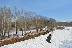
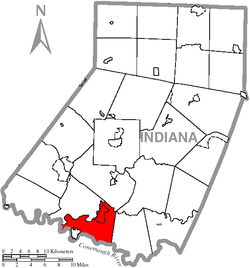
Burrell Township is a township in Indiana County, Pennsylvania, United States. Burrell Township was formed from Black Lick Township in 1853, named after Judge Burrell. The population was 3,525 at the 2020 census, [2] a decline from the figure of 4,393 tabulated in 2010. The township includes the communities of Bell's Mills, Black Lick, Campbells Mill, Fairfield Heights, Josephine, Marshall Heights, Oake's Point, Palmertown, Smith, and Strangford. [3]

Contents

Geography

According to the United States Census Bureau, the township has a total area of 24.5 square miles (63 km2), of which 23.7 square miles (61 km2) is land and 0.8 square miles (2.1 km2) (3.11%) is water. [4]

Demographics

Historical population
CensusPop.Note
1860 1,251
1870 1,3749.8%
1880 1,77028.8%
1890 1,414−20.1%
1900 1,4351.5%
1910 3,109116.7%
1920 4,30838.6%
1930 3,291−23.6%
1940 3,5558.0%
1950 3,478−2.2%
1960 3,476−0.1%
1970 3,6725.6%
1980 4,15213.1%
1990 3,669−11.6%
2000 3,7462.1%
2010 4,39317.3%
2020 3,525−19.8%
2021 (est.)3,511 [2] −0.4%
U.S. Decennial Census [5]

As of the census [6] of 2000, there were 3,746 people, 1,495 households, and 1,079 families residing in the township. The population density was 157.9 inhabitants per square mile (61.0/km2). There were 1,632 housing units at an average density of 68.8 per square mile (26.6/km2). The racial makeup of the township was 97.84% White, 1.58% African American, 0.08% Native American, 0.03% Asian, 0.11% from other races, and 0.37% from two or more races. Hispanic or Latino of any race were 0.45% of the population.

There were 1,495 households, out of which 29.3% had children under the age of 18 living with them, 56.8% were married couples living together, 10.1% had a female householder with no husband present, and 27.8% were non-families. 24.7% of all households were made up of individuals, and 12.3% had someone living alone who was 65 years of age or older. The average household size was 2.45 and the average family size was 2.88.

In the township the population was spread out, with 21.5% under the age of 18, 7.0% from 18 to 24, 27.1% from 25 to 44, 25.6% from 45 to 64, and 18.8% who were 65 years of age or older. The median age was 41 years. For every 100 females there were 95.9 males. For every 100 females age 18 and over, there were 93.7 males.

The median income for a household in the township was $31,366, and the median income for a family was $37,377. Males had a median income of $30,451 versus $21,964 for females. The per capita income for the township was $15,645. About 10.9% of families and 13.7% of the population were below the poverty line, including 21.9% of those under age 18 and 9.2% of those age 65 or over.

Related Research Articles

<span class="mw-page-title-main">Burrell Township, Armstrong County, Pennsylvania</span> Township in Pennsylvania, United States

Burrell Township is a township in Armstrong County, Pennsylvania, United States, and is part of the Pittsburgh metropolitan area. The population was 659 at the 2020 census, a decrease from the figure of 689 tabulated in 2010.

<span class="mw-page-title-main">South Buffalo Township, Pennsylvania</span> Township in Pennsylvania, United States

South Buffalo Township is a township in Armstrong County, Pennsylvania, United States. The population was 2,713 at the 2020 census, an increase from the figure of 2,636 tabulated in 2010.

<span class="mw-page-title-main">Treasure Lake, Pennsylvania</span> Census-designated place in Pennsylvania, United States

Treasure Lake is a census-designated place (CDP) in Clearfield County, Pennsylvania, United States. The population was 5,460 at the 2020 census. Treasure Lake is a semi-private, gated community centered around its namesake.

<span class="mw-page-title-main">Benton Township, Columbia County, Pennsylvania</span> Township in Pennsylvania, United States

Benton Township is a township in Columbia County, Pennsylvania. It is part of Northeastern Pennsylvania. The population was 1,323 at the 2020 census.

<span class="mw-page-title-main">North East Township, Pennsylvania</span> Township in Pennsylvania, United States

North East Township is a township in Erie County, Pennsylvania, United States. The population was 6,530 at the 2020 census, up from 6,315 at the 2010 census, down from 7,702 in 2000.

Black Lick is a census-designated place (CDP) in Burrell Township, Indiana County, Pennsylvania, United States. The population was 1,462 at the 2010 census.

<span class="mw-page-title-main">Black Lick Township, Pennsylvania</span> Township in Pennsylvania, United States

Black Lick Township is a township in Indiana County, Pennsylvania, United States. The population was 1,133 at the 2020 census. The township includes the communities of Grafton, Jacksonville, and Newport.

<span class="mw-page-title-main">Center Township, Indiana County, Pennsylvania</span> Township in Pennsylvania, United States

Center Township is a township in Indiana County, Pennsylvania, United States. The population was 4,443 at the 2020 census. It includes the communities of Aultman, Coral, Coy, Coy Junction, Edgewood, Graceton, Lucerne Mines, Luciusboro, Roberts Addition, Red Barn, Tearing Run, Tide, Two Licks, and Waterman. The borough surrounds, but does not include, the borough of Homer City.

<span class="mw-page-title-main">Conemaugh Township, Indiana County, Pennsylvania</span> Township in Pennsylvania, United States

Conemaugh Township is a township in Indiana County, Pennsylvania, United States. The population was 2,080 at the 2020 census. The township includes the communities of Clarksburg, Foster, Lewisville, McKeeverville, Nowrytown, Tunnelton, and White.

Jacksonville is a census-designated place (CDP) in Indiana County, Pennsylvania, United States. The population was 637 at the 2010 census. It was formerly an independent borough, until January 1, 1993 when it was returned to Black Lick Township, Pennsylvania.

<span class="mw-page-title-main">West Wheatfield Township, Pennsylvania</span> Township in Pennsylvania, United States

West Wheatfield Township is a township in Indiana County, Pennsylvania, United States. The population was 2,164 at the time of the 2020 census.

<span class="mw-page-title-main">Perry Township, Jefferson County, Pennsylvania</span> Township in Pennsylvania, United States

Perry Township is a township in Jefferson County, Pennsylvania, United States. The population was 1,249 at the 2020 census. It was named after Commodore Oliver Hazard Perry.

<span class="mw-page-title-main">French Creek Township, Mercer County, Pennsylvania</span> Township in Pennsylvania, United States

French Creek Township is a township in Mercer County, Pennsylvania, United States. The population was 710 at the 2020 census, a decrease from the figure of 771 in 2010.

<span class="mw-page-title-main">Sandy Creek Township, Pennsylvania</span> Township in Pennsylvania, United States

Sandy Creek Township is a township that is located in Mercer County, Pennsylvania, United States. The population was 800 at the time of the 2020 census, an increase from the figure of 795 that was documented in 2010.

<span class="mw-page-title-main">Black Township, Pennsylvania</span> Township in Pennsylvania, United States

Black Township is a township in Somerset County, Pennsylvania, United States. The population was 899 at the 2020 census. It is part of the Johnstown, Pennsylvania, Metropolitan Statistical Area. The township was named for Jeremiah Sullivan Black, a native of Somerset County who became Chief Justice of the Supreme Court of Pennsylvania, U.S. Attorney General, and U.S Secretary of State.

<span class="mw-page-title-main">Elk Lick Township, Pennsylvania</span> Township in Pennsylvania, United States

Elk Lick Township is a township in Somerset County, Pennsylvania, United States. The population was 2,264 at the 2020 census. Mount Davis, the highest point in Pennsylvania, is located within the township.

<span class="mw-page-title-main">Ogle Township, Pennsylvania</span> Township in Pennsylvania, United States

Ogle Township is a township in Somerset County, Pennsylvania, United States. The population was 467 at the 2020 census. It is part of the Johnstown, Pennsylvania, Metropolitan Statistical Area.

<span class="mw-page-title-main">Quemahoning Township, Pennsylvania</span> Township in Pennsylvania, United States

Quemahoning Township is a township in Somerset County, Pennsylvania, United States. The population was 1,838 at the 2020 census. It is part of the Johnstown, Pennsylvania, Metropolitan Statistical Area.

<span class="mw-page-title-main">Derry Township, Westmoreland County, Pennsylvania</span> Township in Pennsylvania, United States

Derry Township is a township in Westmoreland County, Pennsylvania, United States. It surrounds the borough of Derry, which is a separate municipality. As of the 2020 census, the township population was 13,631.

<span class="mw-page-title-main">Upper Burrell Township, Pennsylvania</span> Township in Pennsylvania, United States

Upper Burrell Township is a township in Westmoreland County, Pennsylvania, United States, within the Pittsburgh metropolitan area. The population was 2,159 at the 2020 census.

References

  1. "2016 U.S. Gazetteer Files". United States Census Bureau. Retrieved August 14, 2017.
  2. 1 2 3 4 Bureau, US Census. "City and Town Population Totals: 2020-2021". Census.gov. US Census Bureau. Retrieved July 6, 2022.
  3. "Indiana County Pennsylvania Township Maps".
  4. "Geographic Identifiers: 2010 Census Summary File 1 (G001): Burrell township, Indiana County, Pennsylvania". American Factfinder. U.S. Census Bureau. Archived from the original on February 13, 2020. Retrieved April 10, 2018.
  5. "Census of Population and Housing". Census.gov. Retrieved June 4, 2016.
  6. "U.S. Census website". United States Census Bureau . Retrieved January 31, 2008.

40°27′00″N79°12′00″W / 40.45000°N 79.20000°W / 40.45000; -79.20000