Glen Campbell is a borough in Indiana County, Pennsylvania, United States. The borough is located about 80 miles (135 km) east of Pittsburgh. Glen Campbell only shares borders with two other municipalities; the townships of Banks to the north, east and west, and Montgomery to the south.
The borough was named in 1889 for Cornelius Campbell, the first superintendent of the Glenwood Coal Company (glen is the Scottish word for valley), which mined in that area. Glen Campbell became a borough on September 27, 1894. ″The petition for Glen Campbell to become a borough is dated March 5, 1894. The papers were presented to the grand jury and after hearing the parties, and a full investigation of the matter, it was found that the law, under Act of Assembly, had been complied with and the prayer of the petitioners was granted. It was authorized that the election be held annually, the third Tuesday of February, as provided by the constitution. The court decreed further that the first election be held October 13, 1894, at the wareroom of B. B. Kime, in the said borough, between the hours of eight o'clock A. M. and seven o'clock P. M., and designated S. J. Smith to give due notice of said election. The court appointed Andrew Patrick judge and William Lewis and D. I. Stadden inspectors.″[4]
Popular singer Glen Campbell visited Glen Campbell in 1971. The distinguished academic Glenn Campbell did also at some point.[5]
Michael William Menosky, a professional baseball player, also known as "Leaping Mike" for his speed and circus-like catches in the outfield, was born in Glen Campbell on October 16, 1894. At some point, the family moved about four miles away to Arcadia. Leaping Mike went on to play baseball from 1914 to 1930. He played for the Pittsburgh Rebels, Washington Senators, and the Boston Red Sox. He replaced Babe Ruth in left field after Babe Ruth was sold to the New York Yankees, beginning what was referred to as "the curse" in Boston.[5]
Glen Campbell, the first coal town in Indiana County, was founded in 1889. It was named for Cornelius Campbell, the first superintendent of the Glenwood Coal Company, the enterprise which initiated mining operations in the area. The town experienced immediate growth and soon a number of coal companies were operating in and around the community. The Hillsdale Coal & Coke Company was formed in 1902 by H. E. Clark, J. D. Ake, S. H. Hicks and J. O. Clark. In 1905, The Clark Brothers Coal Mining Company was established by H. E. Clark, J. O. Clark and S. L. Clark.[4]
In 1894, just five years after its inception, Glen Campbell was incorporated as a borough. The town quickly became the service, business, and shopping center for a number of smaller mining communities that sprang up in northern Indiana County.
By 1900 Glen Campbell was the third largest town in Indiana County. It also had the distinction of being the county's fastest-growing community. In fact, residents of the community felt it was plausible that the county seat would someday be moved to Glen Campbell.
The town was serviced by both the Pennsylvania and New York Central railroads. In addition to coal mining, there were a number of lumber mills. In 1905 the Giant Electric Light, Heat, and Power Company opened operations in Glen Campbell. The company provided electricity to communities in northern Indiana and southern Clearfield counties.
Other industries included a brickyard which was established on the Cush Creek, a stream that flows through the community, and a cooper's shop which manufactured barrels. Later a battery factory was opened. There also were plans for the construction of a foundry and a furniture factory.
At its height of prosperity, the town had approximately sixty businesses. There was an opera house and a nickelodeon. The community boasted its own school system, which included a high school. There were a number of dentists and doctors. One doctor even operated an infirmary for the miners.
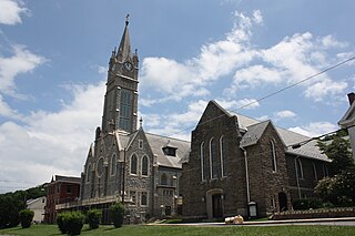
Glen Campbell, PA Capital HotelGC Baptist Church
The borough had its own bank, the First National Bank of Glen Campbell. A number of newspapers were published in the town for instance, The Glen Campbell Comet, H. E. Williams, Publisher, and many social organizations sprang up.
Unfortunately, the bubble burst. Labor unrest, the decline in coal output, the depletion of timber stocks, and a number of disastrous fires left Glen Campbell in serious financial condition. The Great Depression dealt the town its final blow. The bank closed permanently, and a number of businesses either folded or moved elsewhere. The community never recovered.
Although its heyday has long since passed, the town still has the capability of attracting notoriety. It received national attention in 1971 when Glen Campbell, the country music singer, made a surprise visit. The trip was featured in a TV Guide article later that year.
Although no longer the size it once was, Glen Campbell continues to function in its own right. The town's fire company provides fire protection to a number of communities in the area. Its three churches (Methodist, Baptist, and Roman Catholic) all have active congregations. Social organizations include the American Legion and the Glen Campbell Fireman's Auxiliary. The town's post office still provides rural services to a large area surrounding the borough. There are a number of businesses, including some which are coal related, that call Glen Campbell home. [6][7]
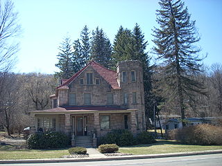
The Sen. Joseph O. Clark House was listed on the National Register of Historic Places in 2011.[8] This house is located in the area referred to by locals as "Candy Bank" or 247 First Avenue. Joseph O. Clark was a state senator from 1921 to 1924 for the 37th district. He was a Republican. He was "Born in Montgomery Township, Indiana County, September 7, 1871, the son of John W. and Adah S. (Hiddlesen) Clark; educated in public schools; Dickinson Seminary (Williamsport); Germantown Academy; Eastman Business College, Poughkeepsie; partner in lumber business at Glen Campbell, Pa.; organizer and board member, First National Bank, Glen Campbell; elected president of same, 1905; investor and director of numerous coal, oil, water, glass, and electric companies throughout the United States; president of Royal Oil and Gas Co., 1936; elected to state Senate, 1921-1924; died July 21, 1936.″' [9]
As of the census[11] of 2000, there were 306 people, 109 households, and 74 families residing in the borough. The population density was 327.8 inhabitants per square mile (126.6/km2). There were 125 housing units at an average density of 133.9 per square mile (51.7/km2). The racial makeup of the borough was 100.00% White.
There were 109 households, out of which 28.4% had children under the age of 18 living with them, 47.7% were married couples living together, 14.7% had a female householder with no husband present, and 32.1% were non-families. 27.5% of all households were made up of individuals, and 15.6% had someone living alone who was 65 years of age or older. The average household size was 2.51 and the average family size was 3.03.
In the borough the population was spread out, with 22.9% under the age of 18, 5.2% from 18 to 24, 22.5% from 25 to 44, 25.8% from 45 to 64, and 23.5% who were 65 years of age or older. The median age was 44 years. For every 100 females there were 100.0 males. For every 100 females age 18 and over, there were 95.0 males.
The median income for a household in the borough was $24,063, and the median income for a family was $31,875. Males had a median income of $24,167 versus $14,688 for females. The per capita income for the borough was $12,039. About 9.6% of families and 16.5% of the population were below the poverty line, including 17.3% of those under the age of eighteen and 10.2% of those sixty five or over.
Related Research Articles
West Terre Haute is a town in Sugar Creek Township, Vigo County, Indiana, on the western side of the Wabash River near Terre Haute. The population was 2,236 at the 2010 census. It is part of the Terre Haute Metropolitan Statistical Area. Bethany Congregational Church was placed on the National Register of Historic Places in 2003.
McCurtain is a town in Haskell County, Oklahoma, United States. The population was 357 at the 2020 census, a 30.8% decrease over the figure of 516 recorded in 2010. A coal mine disaster in 1912 killed 73 miners and ended McCurtain's prosperity. The mine explosion remains one of the worst disasters in Oklahoma history.
Haileyville is a city in Pittsburg County, Oklahoma, United States. The population was 716 at the time of the 2020 United States census.
Elizabeth is a borough in Allegheny County, Pennsylvania, United States, on the east bank of the Monongahela River, where Pennsylvania Route 51 crosses, 15 miles (24 km) upstream (south) of Pittsburgh and close to the county line. The population was 1,398 at the 2020 census. The borough of Elizabeth is entirely contained within the 15037 USPS ZIP code. The local school district is the Elizabeth Forward School District. The borough is home to neighborhoods Walker Heights and Town Hill. Elizabeth Borough is the birthplace of Town Hill Hockey established in 1978.
Jefferson Township is a township in Butler County, Pennsylvania, United States. The population was 5,209 at the 2020 census.
Nanty Glo is a borough in Cambria County, Pennsylvania, United States. It is part of the Johnstown, Pennsylvania metropolitan statistical alrea. The population was 2,734 at the 2010 census. The name comes from the Welsh Nant Y Glo, meaning "The Ravine of Coal."
Lansford is a county-border borough (town) in Carbon County, Pennsylvania, United States. It is part of Northeastern Pennsylvania. It is located 37 miles (60 km) northwest of Allentown and 19 miles south of Hazleton in the Panther Creek Valley about 72 miles (116 km) from Philadelphia and abutting the cross-county sister-city of Coaldale in Schuylkill County.
Houtzdale is a borough in Clearfield County, Pennsylvania, United States. The population was 764 at the 2020 census.
Perryopolis is a borough in Fayette County, Pennsylvania, United States. The borough is part of the Pittsburgh metropolitan area. The population was 1,705 at the 2020 census.
Heilwood is a census-designated place (CDP) in Indiana County, Pennsylvania, United States. The population was 711 at the time of the 2010 census.
Duryea is a borough in the Greater Pittston area of Luzerne County, Pennsylvania, United States, 9 miles (14 km) south of Scranton. The Susquehanna River marks Duryea's western boundary and the Lackawanna River flows through Duryea. It was incorporated as a borough in 1901, and had a notable switching rail yard, the Duryea yard, connecting the central Wyoming Valley to destinations in lower New York and down-state Pennsylvania. Coal mining and silk manufacturing were the chief industries in Duryea's early years. The population was 5,032 at the 2020 census.
Glen Lyon is a census-designated place (CDP) in Newport Township, Pennsylvania, United States. The population was 1,877 at the 2020 census.
Larksville is a borough in Luzerne County, Pennsylvania, United States. It is 2 miles (3 km) west of Wilkes Barre on the Susquehanna River. The population was 4,216 as of the 2020 census.
Warrior Run is a borough in Luzerne County, Pennsylvania, United States. The population was 528 at the time of the 2020 census.
Frackville is a borough in Schuylkill County, Pennsylvania. Incorporated in 1876, Frackville is located at the intersection of Interstate 81 and Pennsylvania State Route 61, which is approximately 102 miles (164 km) northwest of Philadelphia and 60 miles (97 km) southwest of Scranton. Frackville is named for Daniel Frack, an early Anglo-American settler.
St. Clair is a borough in Schuylkill County, Pennsylvania, United States. It is located 2 mi (3.2 km) north of Pottsville in the southern Coal Region. Extensive deposits of hard coal are present.
Central City is a borough in Somerset County, Pennsylvania, United States. The population was 998 at the 2020 census. It is part of the Johnstown, Pennsylvania, Metropolitan Statistical Area. It is east-northeast of Stoystown and northeast of Somerset.
Blossburg is a borough in Tioga County, Pennsylvania, United States. The population was 1,536 at the 2020 census.
Helper is a city in Carbon County, Utah, United States, approximately 110 miles (180 km) southeast of Salt Lake City and 7 miles (11 km) northwest of the city of Price. The population was 2,201 at the 2010 census.
Thurmond is a town in Fayette County, West Virginia, United States, on the New River. The population was five at the 2020 census. During the heyday of coal mining in the New River Gorge, Thurmond was a prosperous town with a number of businesses and facilities for the Chesapeake and Ohio Railway.
1 2 Indiana County, Pennsylvania; her people, past and present, embracing a history of the county by Joshua Thompson Stewart Published 1913; Publisher Chicago, J. H. Beers & co.
This page is based on this Wikipedia article Text is available under the CC BY-SA 4.0 license; additional terms may apply. Images, videos and audio are available under their respective licenses.