Cherryhill Township, Indiana County, Pennsylvania

Last updated

Cherryhill Township,
Indiana County,
Pennsylvania
Penn Run Post Office.jpg
The Post Office in Penn Run, a village in Cherryhill Township
Map of Indiana County, Pennsylvania Highlighting Cherryhill Township.PNG
Map of Indiana County, Pennsylvania Highlighting Cherryhill Township
Map of Pennsylvania highlighting Indiana County.svg
Map of Pennsylvania highlighting Indiana County
Country United States
State Pennsylvania
County Indiana
Area
[1]
  Total49.50 sq mi (128.20 km2)
  Land48.65 sq mi (125.99 km2)
  Water0.85 sq mi (2.20 km2)
Population
 (2020) [2]
  Total2,477 Decrease2.svg
  Estimate 
(2021) [2]
2,462
  Density54.91/sq mi (21.20/km2)
Time zone UTC-5 (Eastern (EST))
  Summer (DST) UTC-4 (EDT)
FIPS code 42-063-13072

Cherryhill Township is a township in Indiana County, Pennsylvania, United States. It was named for Cherry Hill Manor, which was surveyed to the Penns. The population was 2,477 at the 2020 census. [2] It includes the communities of Buck Run, Hustonville, Ideal, Kenwood, Manor, Manver, Mitchell's Mills (previously Diamondville), Penn Run (previously Greenville), Pikes Peak, Rembrandt, Sample Run, and Weimer. [3] The township surrounds but does not include the borough of Clymer.

Contents

History

The George Diehl Homestead was listed on the National Register of Historic Places in 1987. [4]

Geography

According to the United States Census Bureau, the township has a total area of 49.5 square miles (128 km2), of which 48.8 square miles (126 km2) is land and 0.7 square miles (1.8 km2) (1.43%) is water. [5]

Demographics

Historical population
CensusPop.Note
1860 1,758
1870 1,97612.4%
1880 2,24313.5%
1890 1,957−12.8%
1900 1,648−15.8%
1910 2,19833.4%
1920 2,050−6.7%
1930 1,911−6.8%
1940 2,15812.9%
1950 1,955−9.4%
1960 1,721−12.0%
1970 1,7471.5%
1980 2,54045.4%
1990 2,7648.8%
2000 2,8422.8%
2010 2,765−2.7%
2020 2,477−10.4%
2021 (est.)2,462 [2] −0.6%
U.S. Decennial Census [6]

As of the census [7] of 2000, there were 2,842 people, 998 households, and 784 families residing in the township. The population density was 58.2 inhabitants per square mile (22.5/km2). There were 1,099 housing units at an average density of 22.5/sq mi (8.7/km2). The racial makeup of the township was 98.91% White, 0.49% African American, 0.07% Native American, 0.14% Asian, and 0.39% from two or more races. Hispanic or Latino of any race were 0.11% of the population.

There were 998 households, out of which 34.5% had children under the age of 18 living with them, 67.4% were married couples living together, 8.0% had a female householder with no husband present, and 21.4% were non-families. 18.9% of all households were made up of individuals, and 8.1% had someone living alone who was 65 years of age or older. The average household size was 2.72 and the average family size was 3.10.

In the township the population was spread out, with 24.2% under the age of 18, 7.9% from 18 to 24, 27.5% from 25 to 44, 28.8% from 45 to 64, and 11.7% who were 65 years of age or older. The median age was 40 years. For every 100 females, there were 103.4 males. For every 100 females age 18 and over, there were 100.1 males.

The median income for a household in the township was $35,909, and the median income for a family was $40,847. Males had a median income of $32,049 versus $22,045 for females. The per capita income for the township was $14,910. About 7.0% of families and 8.5% of the population were below the poverty line, including 7.6% of those under age 18 and 5.6% of those age 65 or over.

Related Research Articles

Springlee is a neighborhood of St. Matthews, Kentucky, an area of Louisville. The population was 426 at the 2000 census. Until 2000 Springlee was an independent Sixth Class city in Jefferson County, Kentucky, United States. Springlee was incorporated on April 25, 1950. Springlee was dissolved on December 5, 2000, and annexed by the City of St. Matthews on January 8, 2001

<span class="mw-page-title-main">Coe Township, Michigan</span> Civil township in Michigan, United States

Coe Township is a civil township of Isabella County in the U.S. state of Michigan. The population was 3,032 at the 2020 census.

<span class="mw-page-title-main">Harmar Township, Allegheny County, Pennsylvania</span> Township in Pennsylvania, United States

Harmar Township is a township in Allegheny County, Pennsylvania, United States. It contains the communities of Acmetonia, Harmarville, Harmar Heights, and Chapel Downs. The population was 3,136 at the 2020 census. The township was named after Harmar Denny, a U.S. congressman and son of Ebenezer Denny.

<span class="mw-page-title-main">Middlesex Township, Butler County, Pennsylvania</span> Township in Pennsylvania, United States

Middlesex Township is a township in Butler County, Pennsylvania, United States. The population was 6,826 at the 2020 census.

<span class="mw-page-title-main">Penn Township, Butler County, Pennsylvania</span> Township in Pennsylvania, United States

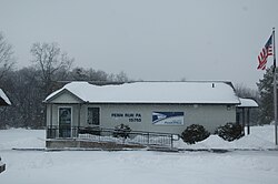
Penn Township is a township that is located in Butler County, Pennsylvania, United States. The population was 4,987 at the time of the 2020 census.

<span class="mw-page-title-main">Summit Township, Butler County, Pennsylvania</span> Township in Pennsylvania, United States

Summit Township is a township that is located in Butler County, Pennsylvania, United States. The population was 4,503 at the time of the 2020 census.

<span class="mw-page-title-main">Graham Township, Clearfield County, Pennsylvania</span> Township in Pennsylvania, United States

Graham Township is a township in Clearfield County, Pennsylvania, United States. The population was 1,329 at the time of the 2020 census.

<span class="mw-page-title-main">Brownsville Township, Pennsylvania</span> Township in Pennsylvania, United States

Brownsville Township is a township in Fayette County, Pennsylvania, United States. The population was 536 at the 2020 census, a decline from the figure of 683 tabulated in 2010. It is served by the Brownsville School District.

<span class="mw-page-title-main">Connellsville Township, Pennsylvania</span> Township in Pennsylvania, United States

Connellsville Township is a township in Fayette County, Pennsylvania, United States. The population was 2,073 at the 2020 census, a decline from the figure of 2,391 tabulated in 2010.

<span class="mw-page-title-main">Dunbar Township, Pennsylvania</span> Township in Pennsylvania, United States

Dunbar Township is a township in Fayette County, Pennsylvania, United States. The population was 6,671 at the 2020 census, a decline from the figure of 7,126 tabulated in 2010.

<span class="mw-page-title-main">Armstrong Township, Indiana County, Pennsylvania</span> Township in Pennsylvania, United States

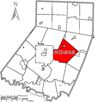
Armstrong Township is a township in Indiana County, Pennsylvania, United States. The township was named after General Armstrong, who commanded the celebration against Kittanning. The population was 2,786 at the 2020 census. The township includes the communities of Crete, Miller, Parkwood, Tannery Village, and Thomas. It surrounds the separately incorporated borough of Shelocta.

<span class="mw-page-title-main">Clymer, Pennsylvania</span> Borough in Pennsylvania, United States

Clymer is a borough in Indiana County, Pennsylvania, United States. The population was 1,336 at the 2020 census. The community was named after William Bingham Clymer, grandson of George Clymer, one of the signers of the United States Declaration of Independence. William Clymer sold the land the borough is situated on to Thomas White in the 1830s. Most of Clymer's family died in a tragic sea accident in 1878, which made national news and inspired the name. It is surrounded by but separate from Cherryhill Township.

<span class="mw-page-title-main">West Brunswick Township, Pennsylvania</span> Township in Pennsylvania, United States

West Brunswick Township is a township located in Schuylkill County, Pennsylvania, United States.

<span class="mw-page-title-main">Carroll Township, Washington County, Pennsylvania</span> Township in Pennsylvania, United States

Carroll Township is a township in Washington County, Pennsylvania, United States. The population was 5,381 at the 2020 census.

<span class="mw-page-title-main">Centerville, Washington County, Pennsylvania</span> Borough in Washington County, Pennsylvania, United States

Centerville is a borough in Washington County, Pennsylvania, United States. The population was 3,254 at the 2020 census.

<span class="mw-page-title-main">East Bethlehem Township, Washington County, Pennsylvania</span> Township in Pennsylvania, United States

East Bethlehem Township is a township in Washington County, Pennsylvania, United States. The population was 2,309 at the 2020 census. The township contains the Frederickstown-Millsboro census-designated place.

<span class="mw-page-title-main">South Franklin Township, Pennsylvania</span> Township in Pennsylvania, United States

South Franklin Township is a township in Washington County, Pennsylvania, United States. The population was 2,864 at the 2020 census.

<span class="mw-page-title-main">Loyalhanna Township, Pennsylvania</span> Township in Pennsylvania, United States

Loyalhanna Township is a township in Westmoreland County, Pennsylvania, United States. As of the 2020 census, the township's total population was 2,093.

<span class="mw-page-title-main">Salem Township, Westmoreland County, Pennsylvania</span> Township in Pennsylvania, United States

Salem Township is a township in Westmoreland County, Pennsylvania, United States. The population was 6,083 at the 2020 census.

Lynnwood-Pricedale is a census-designated place (CDP) in Fayette and Westmoreland counties in the Pennsylvania. The population was 2,031 at the 2010 census, down from 2,168 at the 2000 census. The community of Lynwood is located in Fayette County's Washington Township, while Pricedale is part of Westmoreland County's Rostraver Township.

References

  1. "2016 U.S. Gazetteer Files". United States Census Bureau. Retrieved August 14, 2017.
  2. 1 2 3 4 Bureau, US Census. "City and Town Population Totals: 2020-2021". Census.gov. US Census Bureau. Retrieved July 7, 2022.
  3. http://www.rootsweb.ancestry.com/~paicgs/townships/cherryhill.shtml [ user-generated source ]
  4. "National Register Information System". National Register of Historic Places . National Park Service. July 9, 2010.
  5. "Geographic Identifiers: 2010 Census Summary File 1 (G001): Cheryhill township, Indiana County, Pennsylvania". American Factfinder. U.S. Census Bureau. Archived from the original on February 13, 2020. Retrieved April 11, 2018.
  6. "Census of Population and Housing". Census.gov. Retrieved June 4, 2016.
  7. "U.S. Census website". United States Census Bureau . Retrieved January 31, 2008.

40°38′32″N79°00′26″W / 40.64222°N 79.00722°W / 40.64222; -79.00722