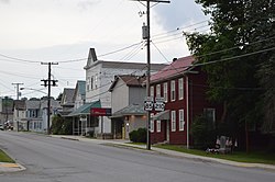
Plumville, Pennsylvania | |
---|---|
Borough | |
Coordinates: 40°47′38″N79°10′49″W / 40.79389°N 79.18028°W | |
Country | United States |
State | Pennsylvania |
County | Indiana |
Government | |
• Type | Borough Council |
Area | |
• Total | 0.50 sq mi (1.28 km2) |
• Land | 0.50 sq mi (1.28 km2) |
• Water | 0.00 sq mi (0.00 km2) |
Population | |
• Total | 255 |
• Density | 514.11/sq mi (198.64/km2) |
Time zone | UTC-5 (Eastern (EST)) |
• Summer (DST) | UTC-4 (EDT) |
Zip code | 16246 |
FIPS code | 42-61632 |
Plumville is a borough in Indiana County, Pennsylvania, United States. The population was 257 at the 2020 census. [3]
The borough was originally named for the presence of wild plum trees. [4]
Plumville is located at 40°47′38″N79°10′49″W / 40.79389°N 79.18028°W (40.793823, -79.180235). [5]
According to the United States Census Bureau, the borough has a total area of 0.5 square miles (1.3 km2), all land. The north branch of Plum Creek passes through Plumville; it is spanned by a bridge constructed in 1918. [6]
A local historical marker states that Plumville was founded in 1818. An 1856 land ownership map depicted it as a small community within South Mahoning township. [7] Telephone service arrived around 1890. [6] : 164 Plumville was incorporated as a borough in December 1909. [8] The 1910 census recorded its population as 414. [9]
The Consolidated Coal and Coke Company's Plumville mine was located in the area west of Redding Run Road. [10] The Pennsylvania Department of Environmental Protection has identified undermined areas within and adjacent to the borough. [11]
Census | Pop. | Note | %± |
---|---|---|---|
1880 | 191 | — | |
1910 | 414 | — | |
1920 | 538 | 30.0% | |
1930 | 518 | −3.7% | |
1940 | 469 | −9.5% | |
1950 | 452 | −3.6% | |
1960 | 401 | −11.3% | |
1970 | 429 | 7.0% | |
1980 | 431 | 0.5% | |
1990 | 390 | −9.5% | |
2000 | 342 | −12.3% | |
2010 | 307 | −10.2% | |
2020 | 257 | −16.3% | |
2021 (est.) | 256 | [3] | −0.4% |
Sources: [12] [13] [14] |
As of the census [13] of 2000, there were 342 people, 123 households, and 92 families residing in the borough. The population density was 673.3 inhabitants per square mile (260.0/km2). There were 145 housing units at an average density of 285.4 per square mile (110.2/km2). The racial makeup of the borough was 98.54% White, 0.29% Native American, and 1.17% from two or more races.
There were 123 households, out of which 34.1% had children under the age of 18 living with them, 62.6% were married couples living together, 7.3% had a female householder with no husband present, and 24.4% were non-families. 22.0% of all households were made up of individuals, and 9.8% had someone living alone who was 65 years of age or older. The average household size was 2.78 and the average family size was 3.23.
In the borough the population was spread out, with 28.9% under the age of 18, 8.5% from 18 to 24, 28.7% from 25 to 44, 21.6% from 45 to 64, and 12.3% who were 65 years of age or older. The median age was 33 years. For every 100 females there were 100.0 males. For every 100 females age 18 and over, there were 100.8 males.
The median income for a household in the borough was $26,964, and the median income for a family was $28,125. Males had a median income of $24,792 versus $20,625 for females. The per capita income for the borough was $14,540. About 22.7% of families and 29.5% of the population were below the poverty line, including 44.9% of those under age 18 and 25.6% of those age 65 or over.
Dravosburg is a borough in Allegheny County, Pennsylvania, United States, and is part of the Pittsburgh Metro Area. The population was 1,612 at the 2020 census. Dravosburg is located along the Monongahela River.
Atwood is a borough in Armstrong County, Pennsylvania, United States. The population was 112 at the 2020 census.
Dayton is a borough in Armstrong County, Pennsylvania, United States. The population was 549 at the 2020 census.
Elderton is a borough in Armstrong County, Pennsylvania, United States. The population was 334 at the 2020 census.
Leechburg is a borough in southern Armstrong County in the U.S. state of Pennsylvania, 35 miles (56 km) northeast of Pittsburgh. A population of 2,149 residents live within the borough limits as of the 2020 census, according to US Census Bureau. Leechburg was founded by David Leech, for whom it was named, and was incorporated as a borough in 1850. Located along the Kiskiminetas River, Leechburg was a major port of the Pennsylvania Canal. Early in the 20th century, it was the site of extensive steel sheet works, foundries, cement plants, and productive coal mines. Leechburg was the first place where natural gas was used for industrial purposes.
Le Raysville is a borough in Bradford County, Pennsylvania, United States. It is part of Northeastern Pennsylvania. The population was 290 at the 2020 census.
Centerville is a borough in Crawford County, Pennsylvania, United States. The population was 178 at the 2020 census, down from 218 at the 2010 census. It was established in 1812.
Townville is a borough in Crawford County, Pennsylvania, United States. The population was 328 at the 2020 census, up from 323 at the 2010 census.
Fayette City is a borough in Fayette County, Pennsylvania, United States. The population was 502 at the 2020 census, a decline from the figure of 596 tabulated in 2010. It is served by the Belle Vernon Area School District. Some buildings in the town antedate 1820.
Vanderbilt is a borough in Fayette County, Pennsylvania, United States. The population was 414 at the 2020 census, a decline from the figure of 476 tabulated in 2010. The town is named for the railroad tycoon Cornelius Vanderbilt and is served by the Connellsville Area School District.
Armagh is a borough in Indiana County in the U.S. state of Pennsylvania. The population was 103 at the 2020 census.
Center Township is a township in Indiana County, Pennsylvania, United States. The population was 4,443 at the 2020 census. It includes the communities of Aultman, Coral, Coy, Coy Junction, Edgewood, Graceton, Lucerne Mines, Luciusboro, Roberts Addition, Red Barn, Tearing Run, Tide, Two Licks, and Waterman. The borough surrounds, but does not include, the borough of Homer City.
Creekside is a borough in Indiana County, Pennsylvania, United States. The population was 284 at the 2020 census.
Ernest is a borough in Indiana County, Pennsylvania, United States. The population was 422 at the 2020 census.
Shelocta is a borough in Indiana County, Pennsylvania, United States. The population was 102 at the 2020 census. The Keystone Generating Station is located to the west of the borough, in Plumcreek Township.
Smicksburg is a borough in Indiana County, Pennsylvania, United States. The population was 57 at the 2020 census, and it is one of the smallest incorporated boroughs in Pennsylvania. It was founded by the Reverend J. George Schmick.
Casselman is a borough in Somerset County, Pennsylvania, United States.
California is a borough on the Monongahela River in Washington County, Pennsylvania, United States. The population was 5,479 as of the 2020 census. It is part of the Pittsburgh metropolitan area.
North Charleroi is a borough in Washington County, Pennsylvania, United States. The population was 1,302 at the 2020 census.
Export is a borough in Westmoreland County, Pennsylvania, United States, surrounded entirely by the Municipality of Murrysville. The population was 893 at the 2020 census.
{{cite book}}
: CS1 maint: multiple names: authors list (link)