Colter Ranch Historic District

Last updated
Colter Ranch Historic District
Colter3.jpg
Overview of the district
USA Arizona location map.svg
Red pog.svg
Usa edcp location map.svg
Red pog.svg
Nearest city Eagar, Arizona
Coordinates 34°06′33″N109°19′32″W / 34.10917°N 109.32556°W / 34.10917; -109.32556 Coordinates: 34°06′33″N109°19′32″W / 34.10917°N 109.32556°W / 34.10917; -109.32556
Area73 acres (30 ha)
Built byPhelps, Micajah H.; Colter, Fred T.
Architectural styleVernacular, Folk
NRHP reference No. 93000626 [1]
Added to NRHPJuly 9, 1993

The Colter Ranch Historic District consists of twelve buildings in a rural setting near Eagar, Arizona. The site is located in the Amity Valley, which itself is part of Round Valley (not to be confused with the Census Designated Place in Arizona of the same name); the Little Colorado River runs along the one side of the district. Most of the buildings date from between 1904 and 1930, the period during which Fred Colter resided on the residence.

Contents

Description

Location of the Colter Ranch Historic District ColterRanch-2.jpg
Location of the Colter Ranch Historic District
Area plan for the Historic District ColterRanch1.jpg
Area plan for the Historic District

Colter Ranch is situated in the portion of Round Valley known as Amity Valley, the valley's name being derived from the Mormon ward which was located here in the 1800s. Eagar and Springerville are the nearest towns. The area is mostly farmland, made possible by irrigation water from the Little Colorado River. [2] :5

The boundaries of the historic district are the Little Colorado River to the north, 4th Street to the south, and School Bus Road to the west. The boundary on the east is less distinct, lying along a section line on a USGS map (T8N, R29E). [2] :23 The Milligan Ditch, bringing irrigation water from the Little Colorado to the historic ranch bisects the district, running east to west. [2] :5

Most of the buildings in the district lie on the southern bank of the ditch, towards the western end of the district. These include three sheds (two wooden, and one corrugated metal); a stuccoed log bunkhouse; a log cabin; a corrugated metal shed; a larger wood storage building, which at one point served as the ranch's commissary; and a wooden machine shop. On the northern side of the ditch can be found a barn, a granary, and a work shed (which is also known as the "little barn"). [2] :5–6

The oldest structure still standing is the log cabin, built ca. 1890. [2] :7 It is a ten by fifteen foot rectangle, the exterior of the building is covered with finished planks, fitted at the corners. The single entrance faces south, away from the Milligan ditch. Its wood-shingled roof is side-gabled with a medium pitch. There is a fireplace on its east side, with a small window on the corresponding west end of the building. [2] :6

Blacksmith shop, bunkhouse, log cabin, shed, and commissary Colter4.jpg
Blacksmith shop, bunkhouse, log cabin, shed, and commissary

The next oldest buildings are the barn, the bunkhouse, the smaller of the wooden sheds, and the storage building (commissary), all of which were constructed circa 1910. [2] :7–8 The barn is the largest building in the district, measuring 60 feet long by 35 feet wide. Two stories tall, the walls are covered with board-and-batt siding, and has a corrugated metal roof of medium pitch. It has two single-story additions. The northern addition is 60 feet long with a shed roof, while the eastern addition runs the length of the original structure, widening the footprint of the barn by 15 feet. It has a lean-to structure. The entire barn complex is enclosed by a corral, which has a split rail fence approximately 5 feet high. Also within the corral is a 15 by 15 foot granary. Built circa 1940, it is constructed with the same materials as the barn, and has a shed roof. [2] :7–8

The bunkhouse has an eastern entrance, and was originally constructed of exposed logs, in the hall-and-parlor style. Two additions were made in the 1930s, giving it its current irregular appearance. The first addition was made to the east side, and consists of a stucco-on-wood-frame construction, while the second was made of concrete to the western side. To the west of the bunkhouse, and the most westernmost of all the structures, is the smallest of the sheds. Approximately 10 feet by 10 feet, it is a single story with an outside surface is covered in vertical wood planking, and it has a corrugated metal roof, with a low-slope. [2] :6

The commissary measures about 30 feet by 16 feet, and has wood board-and-batten siding. The front of the building has a door centered on the building, flanked by two square windows. The other exterior walls have no openings to the outside. It has a corrugated metal gable roof. There is a false commercial "boomtown roof" on the south side, which hides the corrugated roof from view. [2] :6

The next buildings were all built in the 1940s. These include the other two sheds. The wooden shed is about ten by fifteen feet, with a gable roof of medium pitch, sheathed in corrugated metal. Its exterior walls are covered in shiplap wood siding. Its single entrance is off centered on the southern side, and has two small windows. Next to this wooden shed is a small corrugated metal shed. Its walls and roof are of corrugated metal, with the roof being shed-style sloping towards the ditch. [2] :6

The machine shop is a wooden structure with an exterior board-and-batt siding. Approximately 35 by 25 feet, it has a gable roof, facing south, with a corrugated metal surface. The south facing front features a pair of large wooden doors. Across the ditch, on the north side is the "little barn", a small work shed measuring 18 feet by 12 feet. It has a shed roof of corrugated metal, and its walls are unfinished board-and-batt. [2] :6–7

There are also two modern homes within the district, built in the 1980s, which do not contribute to the historicity of the site. [2] :7

History

Log cabin and shed Colter5.jpg
Log cabin and shed

In 1881, Micajah Harris Phelps settled a 160-acre parcel of land straddling the just completed Milligan Ditch. His cattle operation was one of the first large herding operations in Round Valley. When the Amity Ward of the LDS church was created in 1882, Phelps' homestead was located therein. [2] :9 On his death in 1892, his property (which included other ranches in Texas and New Mexico) was split between his three children: Bill Phelps, Sarah Dugan Phelps (known as Duge) and Elizabeth Phelps. Duge maintained the family home in Amity Valley, running a large portion of her father's original herd of 350 cattle.

Bill Phelps enlarged his holdings, and his herd, which had grown to over 1000 head of cattle by the time of his death in 1903. When he died at the age of 51, his one-third share of the Amity Valley property was left to Duge, who then controlled two-thirds of the original homestead. In addition, in order to settle the values of the property distribution of their brothers will, Elizabeth, who had received more valuable property in New Mexico, gave the remaining third of the Amity homestead to Duge. Duge was considered very accomplished and liberated for a woman of that time. She has successfully run her own cattle operation for over ten years by the time she re-consolidated her father's entire homestead. On November 11, 1904, the 40 year-old Duge married the 25 year-old Fred Colter, who had been Bill Phelps' straw boss on Phelps' Apache County operation. [2] :9–10 [3]

Colter, by the time he was 21 had created his own brand, the "Cross Bar". With his marriage to Duge in 1904, the homestead became known as the Colter Ranch. He brought an unknown number of his own cattle to the ranch, in addition to taking control of the 1100 head which were in Duge's herd, as well as over 800 he also managed for Elizabeth. By 1906 he had increased the herd to over 12,000 animals. Two years later, he had developed four reservoirs in the area: Colter, Mexican Hay Lake, Pool Corral, and Hog Wallow. He had also purchased another 3,500 acres extending the homestead's range, as well as up on the mesa to grow alfalfa feed. [2] :15

It was during this timeframe that he built the large barn on the property, to store approximately 40 tons of alfalfa to use as feed for his livestock during the winter. He also built a bunkhouse for his growing number of ranch hands, as well as a commissary where they could purchase any necessities. The commissary was also open for any residents of the nearby ranches. In May 1913, Colter applied for and was granted a post office to be run out of his homestead, which would serve also the local ranches. Named the Colter Post Office, Duge became its first only postmistress, and remained open until 1922. [2] :11–12

By the end of the 1910s, the ranch operation had reached its peak, containing over 43,000 acres of deeded land, and leased acreage surpassing 200,000. It was one of the largest cattle operations in northern Arizona, and it was the largest combined cattle operation and irrigated farming venture in the state. [2] :16–17

After the end of World War I, grain and beef prices fell precipitously. In order to stave off creditors, Colter formed the Northern Arizona Land Company, which issued $450,000 in bonds, using all of the deeded acres as collateral. However, this proved to be only a stopgap measure, and by 1924 creditors began to foreclose on different parcels of property to satisfy the notes. By the early 1930s every piece of land had been foreclosed on. [2] :12 In 1935 the ranch was sold to William A. Spence. The new owner moved the commissary from what is now the intersection of 4th Street and School Bus Road, to its current position. With the wave of mechanized farming taking hold, Spence also constructed the machine shed. [2] :13

Spence sold 1430 acres of the ranch in 1951 to two partners, Victor L. Udall and Gunnar Thude, which included the Colter Ranch. When Udall died later that year, Thude retained about 900 acres, with Udall's heirs taking the other 500, which included the Colter Ranch District. Thude eventually sold his acreage to Louis Johnson and John Wayne, who added additional territory and created the 26 Bar Hereford Ranch. Johnson and Wayne sold the ranch to Tom Chauncey, who currently owns the property. Sam Udall, Victor's son, continues to own the 500 acres which include the historic district. [2] :14–15

See also

Related Research Articles

<span class="mw-page-title-main">Eagar, Arizona</span> Town in Apache County, Arizona

Eagar is a town in Apache County, Arizona, United States. As of the 2010 census, the population of the town was 4,885.

The Snake River Ranch, near Wilson, Wyoming, is the largest deeded ranch in the Jackson Hole area. The ranch buildings are grouped into three complexes comprising headquarters, residential and shop complexes. The ranch combined two neighboring homesteads and was first owned by advertising executive Stanley B. Resor and his wife, Helen Lansdowne Resor. The Resors used the property as a vacation home, but the ranch was also a full-time, self-sustaining operation.

<span class="mw-page-title-main">Sierra Bonita Ranch</span> United States historic place

The Sierra Bonita Ranch, founded in 1872 by Henry C. Hooker, is one of the oldest cattle ranches in the United States and the ranch buildings have been designated a National Historic Landmark. It was the first permanent American cattle ranch in Arizona. Hooker bought neighboring ranches until his operation became the largest ranch in Arizona, totaling 800 square miles (2,100 km2), or about 30 by 27 miles. It is located in Sulphur Springs Valley about 27 miles (43 km) north of present-day Willcox, Arizona. The modern ranch is much smaller but is still operational and owned by Jesse Hooker Davis, the sixth generation to live and work on the ranch.

The Rio Grande Ranch Headquarters Historic District is a historic one-story residence located 3 miles (4.8 km) east of Okay in Wagoner County, Oklahoma. The site was listed on the National Register of Historic Places September 9, 1992. The site's Period of Significance is 1910 to 1935, and it qualified for listing under NRHP criteria A and C.

<span class="mw-page-title-main">Cunningham Cabin</span> Historic house in Wyoming, United States

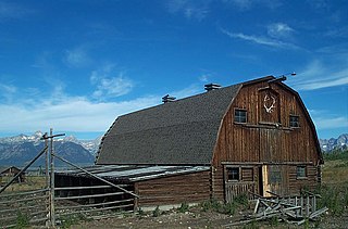
The Cunningham Cabin is a double-pen log cabin in Grand Teton National Park in the US state of Wyoming. It was built as a homestead in Jackson Hole and represents an adaptation of an Appalachian building form to the West. The cabin was built just south of Spread Creek by John Pierce Cunningham, who arrived in Jackson Hole in 1885 and subsisted as a trapper until he established the Bar Flying U Ranch in 1888. The Cunninghams left the valley for Idaho in 1928, when land was being acquired for the future Grand Teton National Park.

<span class="mw-page-title-main">Hunter Hereford Ranch Historic District</span> Historic district in Wyoming, United States

The Hunter Hereford Ranch was first homesteaded in 1909 by James Williams in the eastern portion of Jackson Hole, in what would become Grand Teton National Park. By the 1940s it was developed as a hobby ranch by William and Eileen Hunter and their foreman John Anderson. With its rustic log buildings it was used as the shooting location for the movie The Wild Country, while one structure with a stone fireplace was used in the 1963 movie Spencer's Mountain. The ranch is located on the extreme eastern edge of Jackson Hole under Shadow Mountain. It is unusual in having some areas of sagebrush-free pasture.

<span class="mw-page-title-main">TA Ranch Historic District</span> Historic district in Wyoming, United States

The TA Ranch was the site of the principal events of the Johnson County Range War in 1892. The TA was established in 1882 as one of the first ranches in Johnson County, Wyoming. The TA is the only intact site associated with the range war, with trenches used by both sides still visible and scars on the nearby buildings. The ranch also documents the expansion and development of cattle ranching in Wyoming.

<span class="mw-page-title-main">Buckner Homestead Historic District</span> Historic district in Washington, United States

The Buckner Homestead Historic District, near Stehekin, Washington in Lake Chelan National Recreation Area incorporates a group of structures relating to the theme of early settlement in the Lake Chelan area. Representing a time period of over six decades, from 1889 to the 1950s, the district comprises 15 buildings, landscape structures and ruins, and over 50 acres (200,000 m2) of land planted in orchard and criss-crossed by hand-dug irrigation ditches. The oldest building on the farm is a cabin built in 1889. The Buckner family bought the farm in 1910 and remained there until 1970, when the property was sold to the National Park Service. The Buckner Cabin was listed on the National Register of Historic Places in 1974. The rest of the Buckner farm became a historic district in 1989. Today, the National Park Service maintains the Buckner homestead and farm as an interpretive center to give visitors a glimpse at pioneer farm life in the Stehekin Valley.

<span class="mw-page-title-main">Faraway Ranch Historic District</span> Historic district in Arizona, United States

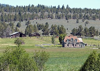
The Faraway Ranch Historic District is part of the Chiricahua National Monument in southeastern Arizona, and preserves an area associated with the final conflicts with the local Apache, one of the last frontier settlements, and in particular, its association with the people who promoted the establishment of the Chiricahua National Monument. Faraway Ranch is located in Bonita Canyon, which lies at an approximate altitude of 5160 feet and opens in a southwesterly direction into the Sulphur Springs Valley.

<span class="mw-page-title-main">Riddle Ranch</span> United States historic place

The Riddle Brothers Ranch is a pioneer ranch complex located in the Steens Mountain Cooperative Management and Protection Area in Harney County in eastern Oregon, United States. It is a rare extant example of the small family ranch. The ranch is located on both sides of the Little Blitzen River on public land and is administered by the Bureau of Land Management.

<span class="mw-page-title-main">James Cant Ranch Historic District</span> Historic district in Oregon, United States

The James Cant Ranch is a pioneer ranch complex in Grant County in eastern Oregon, United States. The ranch is located on both sides of the John Day River in the John Day Fossil Beds National Monument. The ranch was originally homesteaded by Floyd Officer in 1890. Officer sold the property to James Cant in 1910. Cant increased the size of the property and built a modern ranch complex on the west bank of the river. The National Park Service bought the ranch from the Cant family in 1975, and incorporated the property into the John Day Fossil Beds National Monument. The National Park Service used the main house as a visitor center until 2003. Today, the Cant Ranch complex is preserved as an interpretive site showing visitors an early 20th-century livestock ranch. The James Cant Ranch is listed on the National Register of Historic Places.

<span class="mw-page-title-main">Sod House Ranch</span> United States historic place

The Sod House Ranch is a historic ranch in Harney County in southeastern Oregon, United States. The remaining ranch structures are located south of Malheur Lake in the Malheur National Wildlife Refuge. The ranch was built by Peter French, a well known 19th-century cattle baron. The Sod House Ranch became the headquarters for the northern operating division of the French-Glenn Livestock Company, which eventually covered over 140,000 acres (570 km2). After French was murdered in 1897, the French-Glenn Livestock Company slowly sold off its ranch property. In 1935, the United States Government purchased the Sod House Ranch property to add to an adjacent wildlife refuge. The eight remaining Sod House Ranch buildings are now listed on the National Register of Historic Places.

<span class="mw-page-title-main">David L. Shirk Ranch</span> United States historic place

The David L. Shirk Ranch is a historic ranch located in the Guano Valley of eastern Lake County, Oregon, United States. The ranch was originally homesteaded in 1881. It was purchased by David L. Shirk in 1883. He operated the ranch until 1914. The property was acquired by the United States Government in 1942. The ranch is now administered by the Bureau of Land Management. The remaining historic ranch buildings are listed on the National Register of Historic Places.

<span class="mw-page-title-main">Nelson Farm, Nebraska</span> United States historic place

The Nelson Farm is a historic farmstead in rural Merrick County, in the east central part of the state of Nebraska in the Midwestern United States. Originally settled by Swedish immigrants in 1879, it was expanded and improved over the subsequent eighty years and more, remaining in the founder's family into the fourth and fifth generations.

<span class="mw-page-title-main">Roba Ranch</span> United States historic place

The Roba Ranch is a pioneer ranch located near the small unincorporated community of Paulina in Crook County, Oregon. The ranch is named for George and Mary Roba, sheep ranchers who acquired the property in 1892. Most of the important ranch buildings were constructed by the Roba family between about 1892 and 1910. Today, the ranch covers 1,480 acres (6.0 km2) and is privately owned. The ranch was listed on the National Register of Historic Places in 2007.

NAN Ranch, also known as Y Bar NAN Ranch, is a ranch in Faywood, New Mexico, that was added to the National Register of Historic Places in 1988. The property was developed as a ranch beginning in the late-1860s by John Brockman, who grew corn, alfalfa, and several types of fruit and bred cattle. Cattleman John T. McElroy purchased the ranch in 1927 and hired Trost & Trost to renovate and expand the ranch compound to become the NAN Ranch headquarters. The project included a new house, extensive landscaping, swimming pool, a slaughterhouse, powerhouse, and other residential and ranch buildings. It is historically significant due to its architecture and its role as a major 19th century ranch.

<span class="mw-page-title-main">Ryan Ranch</span> United States historic place

The Ryan Ranch is a 2,000-acre (810 ha) ranch on the east bank of the North Platte River in Carbon County, Wyoming, about 8 miles (13 km) south of Saratoga. One of the oldest ranches in the Platte Valley of central Wyoming, it was founded by Barton T. Ryan in 1874 and expanded by his son Cecil A. Ryan. The ranch headquarters comprises 17 structures arranged around a barnyard. The oldest structure is the 1875 homestead. Other buildings include sheds, shops, guest cabins, barns, trailers and a privy.

The Diamond A Ranch, or Spring Ranch, is a ranch in the upper Wind River valley of Fremont County, Wyoming. The site was first settled by John Robert McDonald, a Scottish immigrant who had a 160-acre (65 ha) homestead on the site in 1891. McDonald sold the property to John Williamson in 1907. Jack Williamson and his brother David were Scots as well, working as stonemasons. The Williamsons had worked in New York City, at Princeton University, at the Mormon Temple in Salt Lake City and on bridge work for the Union Pacific Railroad. In 1888 they came from Salt Lake City to Lander, where they worked on a number of projects, as well as in Rawlins and at Fort Washakie. They joined their sister Jean Williamson Sinclair at the Upper Circle Ranch near Dubois in the early 1890s. David Williamson married Annie McKenzie, a friend of his sister's who had come with her from Scotland. When Jack died of tick fever in 1916, David moved to the ranch with his family. After David's death in 1934, his wife Annie operated the ranch until she sold it in 1966. The ranch is notable as one of several ranches established by Scottish immigrants.

<span class="mw-page-title-main">Fred Colter</span> American rancher and politician

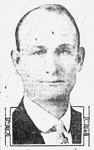
Fred Tuttle Colter was an Arizona rancher and farmer, as well as being the state senator for Apache County beginning with Arizona's second state legislature in 1915. Colter spent six terms in the Arizona Senate. He also led the fight on Arizona's behalf to maintain control over the water from the Colorado River, coining the slogan, "Save the Colorado for Arizona". He was a close ally of the state's first governor, George W. P. Hunt. Prior to his election to the state senate, Colter had served as the state's fair commissioner.

<span class="mw-page-title-main">Eagar Townsite Historic District</span> United States historic place

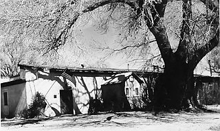
Eagar Townsite Historic District is a section of the town of Eagar, Arizona which has been designated a National Historic Place. Sitting on roughly 54 acres, the site contains 37 structures, 21 of which have historical significance. The period of significance is from 1886, the year the townsite was founded, through 1942, which represents the significant period of development of the town. The site was added to the Register on July 23, 1993.

References

  1. "National Register Information System". National Register of Historic Places . National Park Service. July 9, 2010.
  2. 1 2 3 4 5 6 7 8 9 10 11 12 13 14 15 16 17 18 19 20 21 "National Register of Historic Places Registration Form". National Park Service. Retrieved January 22, 2017.
  3. "Eagar Epistle". Snips & St. Johns Herald (St. Johns, Arizona). June 1, 1901. p. 4. Retrieved January 23, 2017 via Newspapers.com. Open Access logo PLoS transparent.svg