
The term "United States," when used in the geographic sense, refers to the contiguous United States, Alaska, Hawaii, the five insular territories of Puerto Rico, Northern Mariana Islands, U.S. Virgin Islands, Guam, American Samoa, and minor outlying possessions. The United States shares land borders with Canada and Mexico and maritime borders with Russia, Cuba, the Bahamas, and many other countries, mainly in the Caribbeanin addition to Canada and Mexico. The northern border of the United States with Canada is the world's longest bi-national land border.

DeKalb County is located in the north central portion of the U.S. state of Georgia. As of the 2020 census, the population was 764,382, making it Georgia's fourth-most populous county. Its county seat is Decatur.
The Cook Mountains is a group of mountains bounded by the Mulock and Darwin glaciers in Antarctica. They are south of the Worcester Range and north of the Darwin Mountains and the Britannia Range.

The Darwin Glacier is a large glacier in Antarctica. It flows from the polar plateau eastward between the Darwin Mountains and the Cook Mountains to the Ross Ice Shelf. The Darwin and its major tributary the Hatherton are often treated as one system, the Darwin–Hatherton.

Superior National Forest, part of the United States National Forest system, is located in the Arrowhead Region of the state of Minnesota between the Canada–United States border and the north shore of Lake Superior. The area is part of the greater Boundary Waters region along the border of Minnesota and the Canadian province of Ontario, a historic and important thoroughfare in the fur trading and exploring days of New France and British North America.
Georgia's 4th congressional district is a congressional district in the U.S. state of Georgia. The district is currently represented by Democrat Hank Johnson, though the district's boundaries have been redrawn following the 2010 census, which granted an additional congressional seat to Georgia. The first election using the new district boundaries were the 2012 congressional elections.
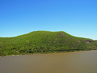
Bull Hill, also known as Mount Taurus, is a mountain north of the village of Cold Spring on the Hudson River in Putnam County in the State of New York. It is part of the river-straddling range known as the Hudson Highlands. The original name came after a bull that used to terrorize the mountain was chased by indignant inhabitants. A hunting party drove the bull over the hill. In an attempt to flee the mountaineers, the bull plunged out into space and fell down. Its broken and shapeless mass on the rocks was memorialized in the name of the mountain the bull used to haunt.
California's 27th congressional district is a congressional district in the U.S. state of California. The district is currently represented by Democrat George T. Whitesides.

Arkansas's 1st congressional district is a U.S. congressional district in eastern Arkansas that elects a representative to the United States House of Representatives. It is currently represented by Republican Rick Crawford. With a Cook Partisan Voting Index rating of R+22, it is the most Republican district in Arkansas, a state with an all-Republican congressional delegation.
Missouri's 1st congressional district is in the eastern portion of the state. It includes all of St. Louis City and much of northern St. Louis County, including the cities of Maryland Heights, University City, Ferguson and Florissant. With a Cook Partisan Voting Index rating of D+27, it is the most Democratic district in Missouri. Roughly half of the district's population is African American.
The Sauratown Mountains, which are sometimes called "the mountains away from the mountains", are an isolated mountain range located within Stokes and Surry counties in the U.S. state of North Carolina. The vast majority of the range is located in Stokes County. Although the range occupies only 5% of Stokes County's area, it dominates the county's scenery from almost every direction. The Sauras rise sharply 800 to 1,700 feet above the surrounding terrain.
Dinglishna Hill is a hill located East of Mount Susitna, in the Matanuska-Susitna Valley of South Central Alaska.
Besboro Island is a small island in the Norton Sound, Bering Sea, off the shores of Alaska. It is located 11 miles (18 km) west of the mainland and 38 miles (61 km) southwest of Christmas Mountain, Nulato Hills.

The Cookes Range is a small, 17-mi (27 km) long mountain range in northern Luna County, New Mexico, which extends slightly north into southeastern Grant County. The range is a southern continuation of the Mimbres Mountains, itself the southeast portion of the extensive north–south running Black Range. The Cookes Range is surrounded by lower elevation areas of the northwest Chihuahuan Desert.
Red Hill is a mountain located in the Catskill Mountains of New York east-south of Frost Valley. Woodhull Mountain is located northeast of Red Hill.
Gallis Hill is a 794-foot-tall (242 m) mountain in the Catskill Mountains region of New York. It is located northwest of Kingston in Ulster County. Jockey Hill is located north-northeast, and Morgan Hill is located west of Gallis Hill. In 1927, the Conservation Department built a steel fire lookout tower on the mountain. In 1950, the tower was closed and disassembled then moved to Overlook Mountain, where it still remains today.
Leonard Hill is a 2,592-foot-tall (790 m) mountain in Schoharie County, New York. It is located east-southeast of North Blenheim. Safford Hill is located northwest and Hubbard Hill is located southeast of Leonard Hill. In 1948, the Conservation Commission built an 80-foot-tall (24 m) steel fire lookout tower on the mountain. The tower ceased fire watching operations at the end of the 1988 season and was officially closed in early 1989. The tower remains on the summit, but is closed to the public. A local group is planning to restore the tower and reopen it to the public.
Henry Hill is a mountain in the town of Berne in Albany County, New York. It is located southeast of Huntersland. It is directly south of the Partridge Run State Forest. Cook Hill is located northwest and Garver Hill is located west-southwest of Henry Hill. Henry Hill is the tallest point in Albany County and it is ranked 25 of 62 on the list of New York County High Points.
West Mountain is a mountain in Albany County, New York. It is located east-northeast of Huntersland. East Hill is located east-northeast and Cook Hill is located southwest of West Mountain.

