Coquet Island

Last updated • 3 min readFrom Wikipedia, The Free Encyclopedia

Coquet Island
Coquet island 3.JPG
Northumberland UK location map.svg
Red pog.svg
Coquet Island
Geography
Location North Sea
Coordinates 55°20′06″N1°32′20″W / 55.335°N 1.539°W / 55.335; -1.539
OS grid reference NU293046
Area6 ha (15 acres)
Administration

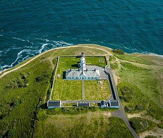
Coquet Island /ˈkkət/ is a small island of about 6 hectares (15 acres), situated 1.2 kilometres (0.75 mi) off Amble on the Northumberland coast, northeast England. It is included in the civil parish of Hauxley. [1]

Contents

Bird reserve

The island is owned by the Duke of Northumberland. The Royal Society for the Protection of Birds manages the island as a bird reserve, for its important seabird colonies.

The most numerous species is the puffin, with over 18,000 pairs nesting in 2002, but the island is most important for the largest colony of the endangered roseate tern in Britain, which, thanks to conservation measures including the provision of nestboxes to protect the nests from gulls and bad weather, has risen to 118 pairs in 2018. Other nesting birds include sandwich tern, common tern, Arctic tern, black-legged kittiwake, fulmar, three other gull species, and eider duck.

The island is uninhabited in winter, but seasonal wardens are present throughout the summer to protect the nesting birds. Landing on Coquet Island for the general public is prohibited, but boats from local companies in Amble sail close up to the island in good weather throughout the summer, allowing visitors to get good views of the puffins and roseate terns.

Coquet Lighthouse

Coquet Island Lighthouse Coquet Island lighthouse close-up - geograph.org.uk - 1366409.jpg
Coquet Island Lighthouse
Coquet Lighthouse
Lighthouse, Coquet Island 1.JPG
The lighthouse
Coquet Island
LocationCoquet Island
Northumberland
England
OS grid NU2930504532
Coordinates 55°20′2″N1°32′23.2″W / 55.33389°N 1.539778°W / 55.33389; -1.539778
Tower
Constructed1841
Built by James Walker   OOjs UI icon edit-ltr-progressive.svg
Constructionsandstone tower
Automated1990
Height22 m (72 ft)
Shapesquare tower with balcony and lantern
Markingsunpainted lower tower, white upper tower and lantern
Power sourcesolar power  OOjs UI icon edit-ltr-progressive.svg
OperatorRoyal Society for the Protection of Birds (Coquet Island Preserve) [2]
HeritageGrade II* listed building  OOjs UI icon edit-ltr-progressive.svg
Fog signal one 2 second blast every 30s.
Light
Focal height25 m (82 ft)
Lens1st order catadioptric fixed lens
Intensitywhite: 155,000 candela
red: 21,830 candela
Rangewhite: 19 nmi (35 km)
red: 15 nmi (28 km)
Characteristic Fl (3) WR 20s.

Coquet Island was the home at one time of Henry of Coquet (died 1127), a Dane who lived in a hermitage there. The island also holds the remaining structure of a medieval monastery on the southwestern shore, which was largely incorporated into the 19th-century lighthouse and lighthouse keepers' cottages.

Coquet Lighthouse was built by Trinity House in 1841 at a cost of £3,268. James Walker designed the lighthouse, which is a white square tower of sandstone, with walls more than one metre thick, surrounded by a turreted parapet. The first keeper at Coquet Lighthouse was William Darling, the elder brother of Grace Darling.

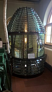
The former optic from Coquet Island Lighthouse. Old lens from Coquet Island Lighthouse.jpg
The former optic from Coquet Island Lighthouse.

The lighthouse was initially provided with a large (first-order) fixed dioptric along with a set of mirrors (which were replaced with refracting prisms ten years later); the lens was by Isaac Cookson & co. of Newcastle upon Tyne. [3] The lamp was oil-fuelled.

In 1854 red sectors were added, to warn ships of Hauxley Point to the south and Boulmer Rocks to the north. [3] Later, in 1870, a separate sector light was added, pointing south from a lower window in the tower. [4] In 1891 both lights were made much more powerful; the main lamp was replaced with an eight-wick mineral-oil burner, [5] and its character was changed to occulting (being eclipsed for 2.5 seconds every minute). [6]

An explosive fog signal was established at the lighthouse in 1902, which sounded once every seven-and-a-half minutes; [7] later sounding every three minutes, it was still in use in the 1970s. [8] The light was electrified in 1976; up until this date a paraffin vapour burner provided the main light, and an old-style Argand lamp provided the sector light. [9]

In 1990 the lighthouse was automated, at which point a revolving array of quartz halogen sealed beam lamps were installed in place of the old optic, [10] [11] with columns of lamps grouped in threes on a rotating pedestal, so as to display three flashes every 30 seconds. Subsequently, these were replaced by a small revolving optic, mounted on an AGA PRB gearless drive. [12] Coquet's light has been solar powered since 2008. [13]

After its removal from the tower, the original 1841–1851 optic was exhibited (along with the old occulting apparatus) at the Trinity House National Lighthouse Museum in Penzance. [14] After the museum closed they were loaned to Souter Lighthouse where they were displayed for a number of years. [15]

See also

Related Research Articles

<span class="mw-page-title-main">Southwold Lighthouse</span> Lighthouse in Southwold, Waveney, Suffolk, England

Southwold Lighthouse is a lighthouse operated by Trinity House in the centre of Southwold in Suffolk, England. It stands on the North Sea coast, acting as a warning light for shipping passing along the east coast and as a guide for vessels navigating to Southwold harbour.

<span class="mw-page-title-main">Farne Islands</span> Island group off Northumberland, England

The Farne Islands are a group of islands off the coast of Northumberland, England. The group has between 15 and 20 islands depending on the level of the tide. They form an archipelago, divided into the Inner Group and the Outer Group. The main islands in the Inner Group are Inner Farne, Knoxes Reef, the East and West Wideopens, and the Megstone; the main islands in the Outer Group are Staple Island, Brownsman, North and South Wamses, Big Harcar, and Longstone. The two groups are separated by Staple Sound. The highest point on Inner Farne is 19 metres (62 ft) above mean sea level and on Staple Island is 14 metres (46 ft).

<span class="mw-page-title-main">Roseate tern</span> Bird in the family Laridae

The roseate tern is a species of tern in the family Laridae. The genus name Sterna is derived from Old English "stearn", "tern", and the specific dougallii refers to Scottish physician and collector Dr Peter McDougall (1777–1814). "Roseate" refers to the bird's pink breast in breeding plumage.

<span class="mw-page-title-main">Amble</span> Town and civil parish in Northumberland, England

Amble is a town on the North Sea coast of Northumberland, England, at the mouth of the River Coquet; Coquet Island is visible from its beaches and harbour. In 2011, the parish of Amble by the Sea had a population of 6,025.

<span class="mw-page-title-main">Souter Lighthouse</span> Lighthouse in England

Souter Lighthouse is a lighthouse located to the North of Whitburn, South Tyneside, England.. Souter Point was the first lighthouse in the world to be actually designed and built specifically to use alternating electric current, the most advanced lighthouse technology of its day. The light was generated by a carbon arc lamp: first lit on 11 January 1871, it was described at the time as 'without doubt one of the most powerful lights in the world'.
<span class="mw-page-title-main">The Skerries, Isle of Anglesey</span> Group of rocky islets in Wales

The Skerries, coming from the Old Norse word sker, are a group of sparsely vegetated rocky islets (skerries), with a total area of about 17 hectares lying 3 kilometres (1.9 mi) offshore from Carmel Head at the northwest corner of Anglesey, Wales. The islands are important as a breeding site for seabirds, and they attract divers, who come to visit the numerous shipwrecks. The Skerries Lighthouse sits atop the highest point in the islands.
<span class="mw-page-title-main">Trevose Head Lighthouse</span> Lighthouse on the north coast of Cornwall, England

Trevose Head Lighthouse is a lighthouse on Trevose Head on the north Cornish coast at grid reference SW850766 lying to the WSW of Padstow and was sited here as there was previously no light from Land's End to Lundy and it would be visible from Cape Cornwall to Hartland Point.

<span class="mw-page-title-main">St Anthony's Lighthouse</span> Lighthouse

St Anthony's Lighthouse is the lighthouse at St Anthony Head, on the eastern side of the entrance to Falmouth harbour, Cornwall, UK. The harbour is also known as Carrick Roads and is one of the largest natural harbours in the world.

<span class="mw-page-title-main">Round Island Light, Isles of Scilly</span> Lighthouse

Round Island Lighthouse, in the Isles of Scilly was designed by William Tregarthen Douglass for Trinity House and completed in 1887. At the time of building it was one of three lights in the Isles of Scilly, the others being the Bishop Rock and St Agnes lighthouse. The light was modernised in 1966, automated in 1987 and the island designated as a Site of Special Scientific Interest (SSSI) in 1995. It is now managed by the Isles of Scilly Wildlife Trust, and except for the maintenance of the Grade II listed lighthouse, landing is not allowed.

The High lighthouse or pillar lighthouse is one of three lighthouses in Burnham-on-Sea, Somerset, England. A Grade II listed building, it is no longer functional as a lighthouse and has been converted for use as a private dwelling.

<span class="mw-page-title-main">Berry Head Lighthouse</span> Lighthouse in Devon, England

Berry Head Lighthouse is an active lighthouse, located at the end of Berry Head near Brixham in Devon, which has been in operation since 4 May 1906. Berry Head is reputedly the shortest lighthouse in Great Britain, but also one of the highest, being only 5 metres (16 ft) tall, but 58 metres (190 ft) above mean sea level. It was also said to be the deepest because the optic was originally turned by a weight falling down a 45 metres (148 ft) deep shaft.
<span class="mw-page-title-main">Needles Lighthouse</span> Lighthouse on the Isle of Wight, UK

The Needles Lighthouse is an active 19th century lighthouse on the outermost of the chalk rocks at The Needles on the Isle of Wight in the United Kingdom, near sea level. Designed by James Walker, for Trinity House at a cost of £20,000, it was completed in 1859 from granite blocks. It stands 33.25 metres (109.1 ft) high and is a circular tower with straight sides. It replaced an earlier light tower on top of a cliff overhanging Scratchell's Bay, which was first lit on 29 September 1786.

<span class="mw-page-title-main">Europa Point Lighthouse</span> Lighthouse on the southeastern tip of Gibraltar

The Europa Point Lighthouse, also referred to as the Trinity Lighthouse at Europa Point and the Victoria Tower or La Farola in Llanito, is a lighthouse at Europa Point, on the southeastern tip of the British Overseas Territory of Gibraltar, on the southern end of the Iberian Peninsula, at the entrance to the Mediterranean Sea.
<span class="mw-page-title-main">Anvil Point Lighthouse</span> Lighthouse

The Anvil Point Lighthouse is a fully-automated lighthouse located at Durlston Country Park near Swanage in Dorset, England. It is owned by Trinity House and currently operated as two holiday cottages.

<span class="mw-page-title-main">Bamburgh Lighthouse</span> Lighthouse

Bamburgh Lighthouse was built by Trinity House in 1910 to guide shipping both passing along the Northumberland coast and in the waters around the Farne Islands. It was extensively modernised in 1975 and is now monitored from the Trinity House Operations and Planning Centre in Harwich. Routine maintenance is carried out by a local attendant. It is the most northerly land-based lighthouse in England.

<span class="mw-page-title-main">Lowestoft Lighthouse</span> Lighthouse in Lowestoft, England

Lowestoft Lighthouse is a lighthouse operated by Trinity House located to the north of the centre of Lowestoft in the English county of Suffolk. It stands on the North Sea coast close to Ness Point, the most easterly point in the United Kingdom. It acts as a warning light for shipping passing along the east coast and is the most easterly lighthouse in the UK.

<span class="mw-page-title-main">Dungeness Lighthouse</span> Lighthouse

Dungeness Lighthouse on the Dungeness Headland started operation on 20 November 1961. Its construction was prompted by the building of Dungeness nuclear power station, which obscured the light of its predecessor which, though decommissioned, remains standing. The new lighthouse is constructed of precast concrete rings; its pattern of black and white bands is impregnated into the concrete. It remains in use today, monitored and controlled from the Trinity House Operations and Planning Centre at Harwich, Essex.

<span class="mw-page-title-main">Farne Lighthouse</span> Lighthouse

Farne Lighthouse is a lighthouse on the southern tip of Inner Farne. Built in the early 19th century, it still functions as a lighthouse and is managed by Trinity House. In 1910 it was one of the first Trinity House lighthouses to be automated.

<span class="mw-page-title-main">Orfordness Lighthouse</span> Grade II listed lighthouse in the United kingdom

Orfordness Lighthouse was a lighthouse on Orford Ness, in Suffolk, England. The 30 metres (98 ft) tower was completed in 1792. Work began on demolition in July 2020, and was completed in August. The light had a range of 25 nautical miles. It was equipped with an AIS transmitter with MMSI 992351016.

<span class="mw-page-title-main">Lighthouses on Lundy</span>

The isle of Lundy has three lighthouses: a pair of active lights built in 1897 and a preserved older lighthouse dating from 1819.

References

  1. Ordnance Survey Explorer Map 332 Alnwick & Amble, revised March 2009
  2. Rowlett, Russ. "Lighthouses of Northeastern England". The Lighthouse Directory. University of North Carolina at Chapel Hill . Retrieved 30 April 2016.
  3. 1 2 "Lighthouse management : the report of the Royal Commissioners on Lights, Buoys, and Beacons, 1861, examined and refuted Vol. 2". 1861. p. 94.
  4. London Gazette, Issue: 23691, Page: 5920, 27 December 1870.
  5. Price Edwards, E. (12 February 1892). "Burning Oils for Lighthouses and Lightships". Journal of the Society of Arts. XL (2, 047): 269.
  6. London Gazette, Issue: 26226, Page: 6235, 24 November 1891.
  7. London Gazette, Issue: 27462, Page: 5124, 8 August 1902.
  8. Jackson, Derrick (1975). Lighthouses of England and Wales. Newton Abbott, Devon: David & Charles. p. 66.
  9. Bland Hague, Douglas; Christie, Rosemary (1975). Lighthouses Their Architecture, History and Archaeology. Llandysul: Gomer Press. p. 157.
  10. Woodman, Richard; Wilson, Jane (2002). The Lighthouses of Trinity House. Bradford-on-Avon, Wilts.: Thomas Reed. pp. 64–66.
  11. Photo, 1990.
  12. "Coquet Lighthouse". trinintyhouse.co.uk. Trinity House. Archived from the original on 6 October 2013. Retrieved 29 October 2013.
  13. "Coquet Island". Visit Northumberland. Retrieved 2 March 2019.
  14. "The Trinity House National Lighthouse Museum". Lighthouse Digest. Retrieved 16 March 2020.
  15. "Souter Lighthouse (National Trust)". Northern Leisure. Retrieved 2 March 2019.
Nautical chart <<Coquet Island Lighthouse>> (1875) ELLIOT(1875) p167 - Plate XVI. Coquet Island, chart of vicinity.jpg
Nautical chart «Coquet Island Lighthouse» (1875)