According to the Pittsburgh History and Landmarks Foundation, the "use of this particular style in the Pittsburgh area, especially work by Shepley, Rutan, and Coolidge, represents an important aspect of the architectural history of the Pittsburgh area."[4]
Coraopolis station shortly after its construction
The building and its sister stations in Glassport and New Castle were constructed in the late 1890s as part of an expansion of the Pittsburgh and Lake Erie Railroad's commuter line into the suburbs of Pittsburgh.[4]
Plans have been made to convert the historic station to a trailside cafe seating 75 and a history museum. In 2014, it was estimated that $1.2 million would be needed for that purpose.[7] In 2015, the Coraopolis Community Development Foundation[8] raised $5000 for structure stabilization,[9] work which officially began October 24, 2015.[10] The foundation has submitted an application for a $250,000 Community Infrastructure and Tourism Fund grant through the Allegheny County Economic Development office to move the project forward. The station sits adjacent to the future Ohio River Greenway Trail[11] which will connect it to the Montour Trail Extension.[10][12] at Coraopolis/Neville Island Bridge.
Gallery
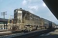
A CSXGE C40-9W locomotive rolls past the Coraopolis Railroad Station in the rain
This page is based on this Wikipedia article Text is available under the CC BY-SA 4.0 license; additional terms may apply. Images, videos and audio are available under their respective licenses.