
Wells is a town in Hamilton County, New York, United States. The population was 674 at the 2010 census. The town is named after Joshua Wells, a land agent, who built the first mills in the area. It is in the Adirondack Park and on the eastern border of the county. It is northwest of Schenectady.

The Blue Mountains are a mountain range in the northwestern United States, located largely in northeastern Oregon and stretching into extreme southeastern Washington. The range has an area of about 15,000 square miles (39,000 km2), stretching east and southeast of Pendleton, Oregon, to the Snake River along the Oregon–Idaho border.

The Cumberland Mountains are a mountain range in the southeastern section of the Appalachian Mountains. They are located in western Virginia, southwestern West Virginia, the eastern edges of Kentucky, and eastern middle Tennessee, including the Crab Orchard Mountains. Their highest peak, with an elevation of 4,223 feet (1,287 m) above mean sea level, is High Knob, which is located near Norton, Virginia.

The Sangre de Cristo Mountains are the southernmost subrange of the Rocky Mountains. They are located in southern Colorado and northern New Mexico in the United States. The mountains run from Poncha Pass in South-Central Colorado, trending southeast and south, ending at Glorieta Pass, southeast of Santa Fe, New Mexico. The mountains contain a number of fourteen thousand foot peaks in the Colorado portion, as well as several peaks in New Mexico which are over thirteen thousand feet.

Mount of the Holy Cross is a high and prominent mountain summit in the northern Sawatch Range of the Rocky Mountains of North America. The 14,011-foot (4270.5 m) fourteener is located in the Holy Cross Wilderness of White River National Forest, 6.6 miles (10.7 km) west-southwest of the Town of Red Cliff in Eagle County, Colorado, United States. The summit of Mount of the Holy Cross is the highest point in Eagle County and the northern Sawatch Range.
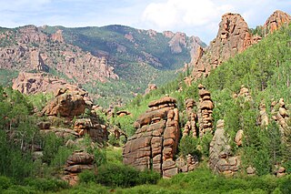
The Lost Creek Wilderness is a 119,790-acre (485 km2) wilderness area located in central Colorado in Jefferson and Park counties, south of the town of Bailey. The area is situated entirely within the boundaries of the Pike National Forest.
The Bighorn National Forest is a U.S. National Forest located in northern Wyoming, United States and consists of over 1.1 million acres (4,500 km2). Created as a US Forest Reserve in 1897, it is one of the oldest government-protected forest lands in the U.S. The forest is well east of the continental divide and extends from the Montana border for a distance of 80 miles (130 km) along the spine of the Bighorn Mountains, an outlying mountain range separated from the rest of the Rocky Mountains by Bighorn Basin. Elevations range from 5,000 feet (1,500 m) along the sagebrush and grass-covered lowlands at the foot of the mountains, to 13,189 feet (4,020 m) on top of Cloud Peak, the highest point in the Bighorn Mountains. Around 99% of the land is above 1,500 metres (4,900 ft). The forest is named after the Bighorn River, which is partially fed by streams found in the forest. Streams in the range are fed primarily by snowmelt and snowmelt mixed with driving rainfall.

North Mountain is a peak in the Catskill Mountains of New York, on the border between the towns of Catskill and Hunter, in Greene County. It is part of the Catskill Escarpment. Cairo Round Top is located northeast and Artists Rock is located southeast of North Mountain.

Green Mountain National Forest is a national forest located in Vermont, a temperate broadleaf and mixed forest typical of the New England/Acadian forests ecoregion. The forest supports a variety of wildlife, including beaver, moose, coyote, black bear, white-tailed deer, wild turkey, and ruffed grouse. The forest, being situated in Vermont's Green Mountains, has been referred to as the granite backbone of the state.

The Great Western Divide is a Sierra Nevada mountain range located largely in Sequoia National Park. Some of the summits of the Great Western Divide reach well over 13,000 feet (3,962 m). The High Sierra Trail crosses the range at Kaweah Gap from Sequoia National Park.
Bear Mountain is one of the best-known peaks of New York's Hudson Highlands. Located partially in Orange County in the town of Highlands and partially in Rockland County in the town of Stony Point, it lends its name to the nearby Bear Mountain Bridge and Bear Mountain State Park that contains it.

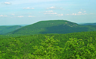
Hibriten Mountain, located just east of Lenoir, North Carolina, marks the western end of the Brushy Mountains range. At 2,211 feet, the mountain's summit is nearly 1,000 feet above the surrounding terrain. The summit is well known to the locals for its large welcome light which glows at night in the shape of a star in the weeks before Christmas and a cross before Easter.

Roan Mountain is a 6,277 ft (1,913 m) mountain straddling the North Carolina/Tennessee border in the Unaka Range of the Southern Appalachian Mountains in the Southeastern United States. The range's highpoint, Roan is clad in a dense stand of Southern Appalachian spruce-fir forest, and includes the world's largest natural rhododendron garden, and the longest stretch of grassy bald in the Appalachian range. The Roan Highlands also contain the highest quality remaining stretch of Fraser fir forest throughout the tree's entire range. The Cherokee National Forest and Pisgah National Forest converge atop the mountain, with Roan Mountain State Park located near its northern base. The Appalachian Trail traverses most of the Roan's crest. The Roan High Knob Shelter is the highest back-country shelter on the entire 2,174-mile (3,499 km) trail.
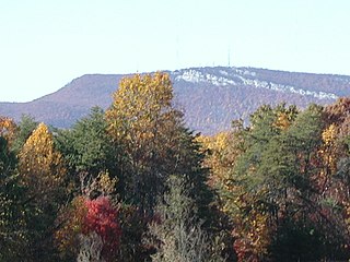
The Sauratown Mountains, which are sometimes called "the mountains away from the mountains", are an isolated mountain range located within Stokes and Surry counties in the U.S. state of North Carolina. The vast majority of the range is located in Stokes County. Although the range occupies only 5% of Stokes County's area, it dominates the county's scenery from almost every direction. The Sauras rise sharply 800 to 1,700 feet above the surrounding terrain.

The Wapack Range, sometimes referred to as the Pack Monadnock Range, is a 20-mile-long (32 km) range of mountains in south-central New Hampshire and adjacent Massachusetts, in the northeastern United States. The range is considered very scenic and rugged with many bare summits and ledges ranging from 1,800 to 2,290 feet. The 22-mile (35 km) Wapack Trail, one of the oldest interstate hiking trails in the United States, traverses it. The Wapack Range is also the northern terminus of the 90-mile (140 km) Midstate Trail.

Alander Mountain is a 2,241-foot-tall (683 m) part of the south Taconic Mountains in southwest Massachusetts and adjacent to New York. The summit is grassy and covered with scrub oak and shrubs; the sides of the mountain are heavily forested. Several trails traverse Alander Mountain, most notably is the 15.7 mi (25.3 km) South Taconic Trail, which passes just beneath the summit.

Mount Van Hoevenberg is a mountain summit located in the Adirondack Mountains in the Town of North Elba, Essex County, New York, about 9 miles (15 km) east-southeast of the village of Lake Placid. Named for Henry Van Hoevenberg, the mountain is best known as the location of a winter sports complex containing bobsleigh, luge, and skeleton tracks, plus a network of cross-country ski trails, which was used to host events during the 1932 (bobsleigh) and 1980 Winter Olympics.
Hogback Mountain is a mountain in southern Vermont, United States, in the town of Marlboro, Vermont, just north of Vermont Route 9. Its main peak is 2,409 feet (734 m) high. The area is well known for expansive views from Route 9.
The Fond du Lac State Forest is a state forest in Minnesota, United States, principally managed by the Minnesota Department of Natural Resources (MDNR). The main segment of the forest is located between the towns of Sawyer and Cromwell, in Carlton County. The boundaries of the forest overlap with those of the Fond du Lac Indian Reservation, some state forest land falls within the reservation. The Kettle Lake Wildlife Management Area is located in the southern half of the main segment. A smaller segment is located adjacent to Jay Cooke State Park and the border with Wisconsin in Saint Louis County.

The Mountain states form one of the nine geographic divisions of the United States that are officially recognized by the United States Census Bureau. It is a subregion of the Western United States.

