Dahachok

Last updated
Dahachok
दहचोक
Dahachowk.jpg
Dahachowk
Nepal adm location map.svg
Red pog.svg
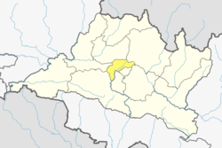
Dahachok
Location in Nepal
Coordinates: 27°42′39″N85°13′42″E / 27.71083°N 85.22833°E / 27.71083; 85.22833
CountryFlag of Nepal.svg   Nepal
Province No. 3
District Kathmandu District
Population
 (2011)
  Total
4,036
Time zone UTC+5:45 (Nepal Time)

Dahachok is a village and former Village Development Committee that is now part of Chandragiri Municipality in Kathmandu District in Province No. 3 of central Nepal. At the time of the 2011 Nepal census it had a population of 4,036. [1] It is located in the west of Kathmandu .

Contents

Toponymy

Language origin

Etymology

“Daha” means lake or pond. “Chok” means square, open space, or village/market center. Therefore, Dahachok can be interpreted as “the square by the pond” or “the open space near the lake.”

Daha (दह) means “lake, pond, reservoir” and comes from Sanskrit दह (daha) meaning “pond, pool, reservoir.” Chok (चोक) means “square, marketplace, central place, yard, plaza, quadrangle, courtyard” and comes from Sanskrit चतुष्क (catuṣka) meaning “crossing, junction,” in Nepali used as “plaza, open center.”

The toponym Dahachok thus combines a geographical feature (pond/lake) with a settlement feature (plaza/marketplace), giving the meaning “the square by the pond.”

Kalu Pande memorial

The burial ground on hill top of Kaji Kalu Pande is a popular hiking spot. It lies in Chandragiri, western outskirts of Kathmandu from where Gorkha can be seen. [2]

References

  1. "VDC Municipality.pdf" (PDF). Archived from the original (PDF) on 2013-01-24. Retrieved 2012-11-01.
  2. "Kalu Pandey Burial Ground being popular among Kathmandu hikers". thehimalayantimes.com. 26 March 2017. Retrieved 7 March 2018.