
Brightwater is a town 20 kilometres (12 mi) southwest of Nelson in Tasman district in the South Island of New Zealand. It stands on the banks of the Wairoa River. Brightwater was first named Spring Grove. Alfred Saunders, the owner of a local flax mill situated on the banks of the Wairoa River and a prominent temperance activist, renamed it Brightwater because of the clarity of the water in Wairoa River. The settlement was named in 1855, but the area was settled as early as 1843.

The Cook River / Weheka is in the South Island of New Zealand. The headwaters are from the La Perouse Glacier on the western flanks of the Southern Alps / Kā Tiritiri o te Moana, and it flows west, then northeast, then northwest and into the Tasman Sea. Its tributaries include the Balfour River, fed by Balfour Glacier, and the Fox River, fed by Fox Glacier / Te Moeka o Tuawe. Much of the river lies within the Westland Tai Poutini National Park. The river was renamed from Cook River to Cook River / Weheka as a result of the Ngāi Tahu Claims Settlement Act 1998.
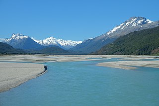
The Dart River flows through rugged forested country in the southwestern South Island of New Zealand. Partly in Mount Aspiring National Park, it flows south-west and then south for 60 kilometres (37 mi) from its headwaters in the Southern Alps and the Dart Glacier, eventually flowing into the northern end of Lake Wakatipu near Glenorchy.
The Inangahua River is located in the north-west of New Zealand’s South Island. It is a major tributary of the Buller River, where it joins at the town of Inangahua Junction.
Dart River may refer to any of several rivers:
The Cobb River is a river in the Tasman Region of New Zealand. It flows southeast from Lake Cobb on the northern slopes of Mount Cobb, in Kahurangi National Park, in the northwestern South Island. The river's waters are captured behind a dam to become the Cobb Reservoir; the outflow continues to join with the Tākaka River. The river is named for J.W. Cobb, a local mill owner.
The Deepdale River is a river of New Zealand located in the Tasman Region of the South Island.
The Devil River is a river of New Zealand's Tasman Region. It starts between the Devil Range and the Anatoki Range and flows generally east through the Kahurangi National Park, reaching the Waingaro River.
The Fyfe River is a river in the Tasman District of New Zealand. It arises in the Marino Mountains near Mount Owen and flows north, then south-west, south and south-east to join the Owen River, a tributary of the Buller River, which eventually exits into the Tasman Sea.
The Gorge River is a river on the West Coast of New Zealand. It arises in the Hope Blue River Range and flows south-west into the Tasman Sea. Its tributaries include the Duncan River and Jerry River. It passes through Cascade Forest. Its mouth is about 15 km north-east of Awarua Point. The Gorge Islands are very small islands near the mouth. At its mouth, it is a fast tidal river.
The Gunn River is a river on the West Coast of New Zealand. It starts in the Price Range in Westland Tai Poutini National Park and flows east into the Whataroa River, which eventually drains into the Tasman Sea.
The Hacket River is a river on the West Coast of New Zealand. It starts in the Malcolm Range and flows south-west into the Tasman Sea.
The Hall River is a river on the West Coast of New Zealand. It drains Lake Paringa, flowing north to the Paringa River, which drains into the Tasman Sea.
The Hapuka River is a river of Westland District, New Zealand. It flows from near The Woolsack north-west to join the Okuru and Turnbull Rivers just before they enter the Tasman Sea. The river is slow-moving and drains swampy land. There are brown trout in the lagoon area.

The Harman River is a river of New Zealand. It starts in the Browning Range of the Southern Alps and becomes the Arahura River, which flows into the Tasman Sea north of Hokitika.

The Fox River is a river in the Westland District of New Zealand. It arises in two places; from a spring in the Fox Range, and from the head of the Fox Glacier. It runs west into the Cook River / Weheka, shortly before it exits into the Tasman Sea.
The Duncan River is a river in the West Coast Region of New Zealand. It arises in the Red Hills Range and flows north-east to the Gorge River, which flows west into the Tasman Sea.
Mount Franklin is a peak in the Nelson Lakes National Park in the Tasman Region of New Zealand. It is the northernmost – and highest – of New Zealand's four Mounts Franklin, located 15 kilometres (9.3 mi) south of Lake Rotoroa. It is the highest peak in the Tasman Region, just two metres higher than the nearby Mount Travers.
Bronte, a locality in the Tasman District of New Zealand, lies between Richmond and Māpua.
Woodstock is a small settlement in the Tasman District of the northern South Island of New Zealand. It is located on the Motueka Valley Highway, close to the eastern bank of the Motueka River, some 20 kilometres southwest of Motueka, at the junction of the Motueka River and its small tributary, the Dove River.


