Dennison Township, Pennsylvania

Last updated

Dennison Township, Pennsylvania
NSP Weather-Beaten.jpg
An abandoned silo in Dennison Township
Map of Luzerne County, Pennsylvania Highlighting Dennison Township.PNG
Map of Luzerne County highlighting Dennison Township
Map of Pennsylvania highlighting Luzerne County.svg
Map of Pennsylvania highlighting Luzerne County
Country United States
State Pennsylvania
County Luzerne
Area
[1]
  Total35.56 sq mi (92.10 km2)
  Land35.43 sq mi (91.76 km2)
  Water0.13 sq mi (0.34 km2)
Population
 (2020) [2]
  Total961 Decrease2.svg
  Estimate 
(2021) [2]
969
  Density31.56/sq mi (12.18/km2)
Time zone UTC-5 (Eastern (EST))
  Summer (DST) UTC-4 (EDT)
FIPS code 42-079-18868
Website dennisontwp.org

Dennison Township is a township in Luzerne County, Pennsylvania, United States. The population was 961 at the 2020 census. [2]

Contents

History

It is believed that Israel Inman was the first white settler in the township. He traveled up Nescopeck Creek from its mouth in 1833. The next party after Inman was the Lehigh Coal & Navigation Company. In 1837, they cut a road through the township in order to get to Wilkes-Barre. This was succeeded by the construction of railroads in the following decades. [3] Dennison Township was formed from a section of the original Hanover Township in 1839. At the time, the new township included what is now Foster Township; it broke away in the 1850s. Logging was a major industry in the area due to the abundance of trees. [3]

Geography

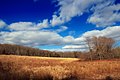
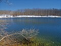
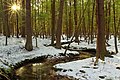
According to the United States Census Bureau, the township has a total area of 35.6 square miles (92.1 km2), of which 35.4 square miles (91.8 km2) is land and 0.12 square miles (0.3 km2), or 0.37%, is water. A vast majority of Dennison Township is made up of thick forests. The township is scarcely populated; most of its residents live in the southeastern portion of the township. A few farms are also located in this section of the community. Many small lakes and streams (e.g., Creasy Creek and Nescopeck Creek) are scattered throughout Dennison. The Lehigh River forms the township's southeastern border. Nescopeck State Park makes up the western part of the township.

Transportation

I-476 travels through the northeastern section of Dennison Township. I-80 travels through the southwestern portion of the community. PA 437 travels through the heart of the township.

Demographics

Historical population
CensusPop.Note
2000 908
2010 1,12523.9%
2020 961−14.6%
2021 (est.)969 [2] 0.8%

At the 2000 census there were 908 people, 375 households, and 255 families living in the township. The population density was 26.2 inhabitants per square mile (10.1/km2). There were 492 housing units at an average density of 14.2/sq mi (5.5/km2). The racial makeup of the township was 99.01% White, 0.22% African American, 0.22% Native American, and 0.55% from two or more races. Hispanic or Latino of any race were 0.99%. [4]

There were 375 households, 26.9% had children under the age of 18 living with them, 54.4% were married couples living together, 8.3% had a female householder with no husband present, and 32.0% were non-families. 27.5% of households were made up of individuals, and 12.8% were one person aged 65 or older. The average household size was 2.42 and the average family size was 2.96.

The age distribution was 20.4% under the age of 18, 6.1% from 18 to 24, 28.9% from 25 to 44, 28.6% from 45 to 64, and 16.1% 65 or older. The median age was 42 years. For every 100 females, there were 105.0 males. For every 100 females age 18 and over, there were 102.5 males.

The median household income was $41,875 and the median family income was $51,563. Males had a median income of $36,667 versus $24,145 for females. The per capita income for the township was $21,373. About 5.8% of families and 5.7% of the population were below the poverty line, including 5.6% of those under age 18 and 11.6% of those age 65 or over.

Education

Dennison Township is part of Crestwood School District.

Related Research Articles

<span class="mw-page-title-main">Kidder Township, Pennsylvania</span> Place in Pennsylvania, United States

Kidder Township is a township in Carbon County, Pennsylvania. It is part of Northeastern Pennsylvania. The population was 1,935 at the 2010 census, up from 1,185 at the 2000 census.

<span class="mw-page-title-main">Beaver Township, Columbia County, Pennsylvania</span> Township in Pennsylvania, United States

Beaver Township is a township in Columbia County, Pennsylvania. It is part of Northeastern Pennsylvania. The population was 879 at the 2020 census. Beaver Township is named for Beaver Run, a tributary of Catawissa Creek, both of which run through the township.

<span class="mw-page-title-main">Mainville, Pennsylvania</span> Census-designated place in Pennsylvania, United States

Mainville is a census-designated place in Columbia County, Pennsylvania, United States. It is part of Northeastern Pennsylvania. The population was 134 at the 2020 census. It is part of the Bloomsburg-Berwick micropolitan area.

<span class="mw-page-title-main">South Newton Township, Pennsylvania</span> Township in Pennsylvania, United States

South Newton Township is a township in Cumberland County, Pennsylvania, United States. The population was 1,383 at the 2010 census.

<span class="mw-page-title-main">Highland Township, Elk County, Pennsylvania</span> Township in Pennsylvania, United States

Highland Township is a township in Elk County, Pennsylvania, United States. The population was 398 at the 2020 census, down from 492 in 2010.

<span class="mw-page-title-main">Spring Creek Township, Elk County, Pennsylvania</span> Township in Pennsylvania, United States

Spring Creek Township is a township in Elk County, Pennsylvania, United States. The population was 198 at the 2020 census, down from 233 in 2010.

<span class="mw-page-title-main">Greenfield Township, Erie County, Pennsylvania</span> Township in Pennsylvania, United States

Greenfield Township is a township in Erie County, Pennsylvania, United States. The population was 1,804 at the 2020 census,

<span class="mw-page-title-main">Venango Township, Erie County, Pennsylvania</span> Township in Pennsylvania, United States

Venango Township is a township in Erie County, Pennsylvania, United States. The population was 2,256 at the 2020 census,

<span class="mw-page-title-main">Upper Tyrone Township, Pennsylvania</span> Township in Pennsylvania, United States

Upper Tyrone Township is a township that is located in Fayette County, Pennsylvania, United States. The population was 1,768 at the time of the 2020 census. It is served by the Southmoreland School District.

<span class="mw-page-title-main">Heidelberg Township, Lehigh County, Pennsylvania</span> Township in Pennsylvania, United States

Heidelberg Township is a township in Lehigh County, Pennsylvania, United States. The population of Heidelberg Township was 3,416 at the 2010 census. It is a suburb of Allentown in the Lehigh Valley, which had a population of 861,899 and was the 68th-most populous metropolitan area in the U.S. as of the 2020 census.

<span class="mw-page-title-main">Black Creek Township, Pennsylvania</span> Township in Pennsylvania, United States

Black Creek Township is a township in Luzerne County, Pennsylvania, United States. The population was 1,904 as of the 2020 census.

<span class="mw-page-title-main">Butler Township, Luzerne County, Pennsylvania</span> Township in Pennsylvania, United States

Butler Township is a township in Luzerne County, Pennsylvania, United States. The population was 9,469 at the 2020 census.

<span class="mw-page-title-main">Exeter Township, Luzerne County, Pennsylvania</span> Township in Pennsylvania, United States

Exeter Township is a township within the Greater Pittston area of Luzerne County, Pennsylvania, United States. The population was 2,047 at the 2020 census. Upper Exeter and Harding are two villages in the township.

<span class="mw-page-title-main">Hollenback Township, Pennsylvania</span> Township in Pennsylvania, United States

Hollenback Township is a township which is located in Luzerne County, Pennsylvania, United States. The population was 1,125 at the time of the 2020 census.

<span class="mw-page-title-main">Mountain Top, Pennsylvania</span> Census-designated place in Pennsylvania, United States

Mountain Top is an unincorporated area and census-designated place (CDP) in Luzerne County, Pennsylvania, United States. As of the 2010 census, its population was 10,982.

<span class="mw-page-title-main">Nescopeck Township, Pennsylvania</span> Township in Pennsylvania, United States

Nescopeck Township is a township in Luzerne County, Pennsylvania, United States. As of the 2020 census, the township population was 1,080.

<span class="mw-page-title-main">Sugarloaf Township, Luzerne County, Pennsylvania</span> Township in Pennsylvania, United States

Sugarloaf Township is a township that is located in Luzerne County, Pennsylvania, United States. The population was 3,879 at the time of the 2020 census.

<span class="mw-page-title-main">Hamilton Township, McKean County, Pennsylvania</span> Township in Pennsylvania, United States

Hamilton Township is a township in McKean County, Pennsylvania, United States. The population was 553 at the 2020 census.

<span class="mw-page-title-main">West Chillisquaque Township, Pennsylvania</span> Township in Pennsylvania, United States

West Chillisquaque Township is a township in Northumberland County, Pennsylvania, United States. The population at the 2010 Census was 2,627, a decline from the figure of 2,846 tabulated in 2000.

<span class="mw-page-title-main">Conewago Township, York County, Pennsylvania</span> Township in Pennsylvania, United States

Conewago Township is a township in York County, Pennsylvania, United States. The township encompasses the land between the Conewago Creek and the Little Conewago Creek, west of their conjunction. The township was formed in 1818 from the northeastern portion of Dover Township and the southeastern portion of Newberry Township and consists of approximately 11,000 acres. The population was 8,527 at the 2020 census.

References

  1. "2016 U.S. Gazetteer Files". United States Census Bureau. Retrieved August 14, 2017.
  2. 1 2 3 4 Bureau, US Census. "City and Town Population Totals: 2020—2021". Census.gov. US Census Bureau. Retrieved August 3, 2022.
  3. 1 2 "Denison Township".
  4. "U.S. Census website". United States Census Bureau . Retrieved January 31, 2008.

41°05′00″N75°49′59″W / 41.08333°N 75.83306°W / 41.08333; -75.83306