Washington County is a regional economic, educational, and cultural hub in the Northwest Arkansas region. Created as Arkansas's 17th county on November 30, 1848, Washington County has 13 incorporated municipalities, including Fayetteville, the county seat, and Springdale. The county is also the site of small towns, bedroom communities, and unincorporated places. The county is named for George Washington, the first President of the United States. Located within the Ozark Mountains, the county is roughly divided into two halves: the rolling Springfield Plateau in the more populous north of the county and the steeper, forested Boston Mountains in the much less populated south. It contains three segments of the Ozark National Forest, two state parks, two Wildlife Management Areas, the Garrett Hollow Natural Area, and dozens of city parks. Other historical features such as Civil War battlefields, log cabins, one-room school houses, community centers, and museums describe the history and culture of Washington County. Washington County occupies 951.72 square miles and contained a population of 245,871 people in 89,249 households as of the 2020 Census, ranking it 4th in size and 3rd in population among the state's 75 counties. The economy is largely based on the business/management, education, sales, office/administration, and poultry production industries. Poverty rates, median household income, and unemployment rates best state averages, but lag national trends. Washington County has long had a reputation for education in the state. The University of Arkansas, the largest four-year college in the state, was established in Fayetteville in 1871. A Washington County campus of the Northwest Arkansas Community College was opened in 2019 in Springdale. Today, Washington County contains eight public school districts, including two of the largest districts in the state and two private schools. It is included in the Fayetteville–Springdale–Rogers Metropolitan Statistical Area.
Rogers is a city in Benton County, Arkansas, United States. Located in the Ozarks, it is part of the Northwest Arkansas region, one of the fastest growing metro areas in the country. Rogers was the location of the first Walmart store, whose corporate headquarters is located in neighboring Bentonville. Daisy Outdoor Products, known for its air rifles, has both its headquarters and its Airgun Museum in Rogers. The city houses a popular shopping center, the Pinnacle Hills Promenade, and a music venue, the Walmart AMP, that has housed performances by big-name artists and local performers alike.

Russellville is the county seat and largest city in Pope County, Arkansas, United States, with a 2022 estimated population of 29,133. It is home to Arkansas Tech University. Arkansas Nuclear One, Arkansas' only nuclear power plant is nearby. Russellville borders Lake Dardanelle and the Arkansas River.

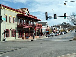
Fayetteville is the second-most populous city in the U.S. state of Arkansas, the county seat of Washington County, and the most populous city in Northwest Arkansas. The city had a population of 93,949 as of the 2020 census, which was estimated to have increased to 101,680 by 2023. The city is on the outskirts of the Boston Mountains, within the Ozarks. It was named after Fayetteville, Tennessee, from which many settlers had come, and was incorporated on November 3, 1836. Fayetteville is included in the three-county Fayetteville–Springdale–Rogers metropolitan statistical area, with 576,403 residents in 2020.

Arkansas Highway 16 is a designation for three state highways in Arkansas. One segment of 24.13 miles (38.83 km) runs from U.S. Route 412 in Siloam Springs east to Interstate 49 (I-49) in Fayetteville. A second segment of 71.67 miles (115.34 km) runs from I-49 in Fayetteville east to Highway 7 in the Ozark National Forest. A third segment of 132.69 miles (213.54 km) runs from Highway 7 at Sand Gap east to US 67B in Searcy. Highway 16 was created during the 1926 Arkansas state highway numbering, and much of the highway winds through the Ozarks, including the Ozark National Forest, where a portion of it is designated as an Arkansas Scenic Byway. The route has two spur routes in Northwest Arkansas; in Fayetteville and Siloam Springs.

A total of ten special routes of U.S. Route 71 exist, and another ten previously existed.

The following outline is provided as an overview of and topical guide to the U.S. state of Arkansas:

Arkansas Highway 45 is a designation for three state highways in Northwest Arkansas. One segment of 26.97 miles (43.40 km) runs from Highway 96 north to Interstate 540 (I-540) in Fort Smith. A second segment of 10.64 miles (17.12 km) runs from Highway 59 north of Dutch Mills north to U.S. Route 62 (US 62) east of Lincoln. A third segment of 25.42 miles (40.91 km) runs from College Avenue in Fayetteville north to Highway 12 west of Clifty. These routes were formerly connected until a portion of approximately 50 miles (80 km) was redesignated Highway 59 and many United States highways were rerouted through Fayetteville.
The University of Arkansas Campus Historic District is a historic district that was listed on the National Register of Historic Places on September 23, 2009. The district covers the historic core of the University of Arkansas campus, including 25 buildings.

Sixteen special routes of U.S. Route 62 currently exist. Seven of them lie within the state of Arkansas. Three existed in the past but have since been decommissioned.

Twelve special routes of U.S. Route 63 currently exist. Arkansas and Missouri each contain five, with two in Iowa. There are also five former routings that have been removed from the system.

Arkansas Highway 190 is a designation for four state highways in Arkansas. Three are low-traffic rural highways in Grant County, with one designation along city streets in Pine Bluff. The rural segments were created in 1965 and 1966, with the Pine Bluff section created in 2000 as a renumbering of Highway 104. All segments are maintained by the Arkansas Department of Transportation (ARDOT).
The Washington County Courthouse is the name of a current courthouse and that of a historic one in Fayetteville, Arkansas, the county seat of Washington County. The historic building, built in 1905, was listed on the National Register of Historic Places in 1972. The historic courthouse is the fifth building to serve Washington County, with the prior buildings located on the Historic Square where the Old Post Office is today. The building is one of the prominent historic buildings that compose the Fayetteville skyline, in addition to Old Main.

The Fayetteville Historic Square, in Fayetteville, Arkansas, includes the original Fayetteville post office, the Old Bank of Fayetteville Building, the Lewis Brothers Building, the Mrs. Young Building, and the Guisinger Building. These buildings are listed in the National Register of Historic Places. There are several more recent buildings located on the Square.

The Wilson Park Historic District is a historic district in Fayetteville, Arkansas, USA, located just northeast of the University of Arkansas. The district consists of several residential buildings that developed during the late 19th and early 20th Century near Wilson Park just north of Dickson Street, the city's primary entertainment district. Wilson Park Historic District includes 47 contributing buildings.

Headquarters House, also known as the Colonel Tebbetts place, is a historic house museum at 118 East Dickson Street in Fayetteville, Arkansas. Built in 1850, it saw action in the American Civil War, serving as a headquarters for both the Union and Confederacy. During the action at Fayetteville, the house was attacked by Confederate troops while serving as a Union outpost. The building was donated to the Washington County Historical Society as a museum in 1967 and was placed on the National Register of Historic Places in 1971.

Mount Nord Historic District is a historic district in Fayetteville, Arkansas encompassing one city block with five properties. The district lies atop a rise of about 140 feet (43 m) above the surrounding area. The properties were built between 1901 and 1925 in various architectural styles, and the area was listed on the National Register of Historic Places in 1982.

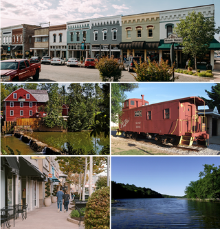
Northwest Arkansas (NWA) is a metropolitan area and region in Arkansas within the Ozarks. It includes four of the ten largest cities in the state: Fayetteville, Springdale, Rogers, and Bentonville, the surrounding towns of Benton and Washington counties, and adjacent rural Madison County, Arkansas. The United States Census Bureau-defined Fayetteville–Springdale–Rogers Metropolitan Statistical Area includes 3,213.01 square miles (8,321.7 km2) and 590,337 residents, ranking NWA as the 98th most-populous metropolitan statistical area in the U.S. and the 13th fastest growing in the United States.

Washington–Willow Historic District is a residential neighborhood of Fayetteville, Arkansas containing over one hundred historically and architecturally significant homes. Styles range from those popular in the mid-19th century through present day, predominantly Victorian, Italianate, neoclassical, and craftsman bungalows. Historically, Fayetteville leaders in business, law and education have all called the district home. The homes sit at the foot of East Mountain within the Masonic Addition, the first addition platted following incorporation.
U.S. Route 71 is a U.S. route that runs from Krotz Springs, LA to the Fort Frances–International Falls International Bridge at the Canadian border. In Arkansas, the highway runs from the Louisiana state line near Doddridge to the Missouri state line near Bella Vista. In Texarkana, the highway runs along State Line Avenue with US 59 and partially runs in Texas. Other areas served by the highway include Fort Smith and Northwest Arkansas.