
Harris Hill is a hamlet and census-designated place (CDP) located in the town of Clarence in Erie County, New York, United States. The population was 5,508 at the 2010 census. It is part of the Buffalo–Niagara Falls Metropolitan Statistical Area. The region is named after Asa Harris, a former officer in the American Colonial Army, who established a tavern near the top of a low hill northeast of Buffalo.

Rock Hill is the largest city in York County, South Carolina, United States, and the fifth-largest city in the state. It is also the fourth-largest city of the Charlotte metropolitan area, behind Charlotte, Concord, and Gastonia. As of the 2010 Census, the population was 66,154. In 2019, the population had increased to 75,048. As of 2017, the total population of the Rock Hill Census County Division was estimated at 117,375 people.

The Texas Hill Country is a geographic region of Central and South Texas, forming the southeast part of the Edwards Plateau. Given its location, climate, terrain, and vegetation, the Hill Country can be considered the border between the American Southeast and Southwest. The region represents the very remote countryside of Central Texas but also is home to growing suburban neighborhoods and affluent retirement communities.
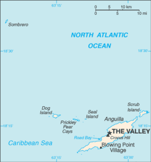
The Valley is the capital of Anguilla, one of its fourteen districts, and the main town on the island. As of 2011, it had a population of 1,067.

Hudson Highlands State Park is a non-contiguous state park in the U.S. state of New York, located on the east side of the Hudson River. The park runs from Peekskill in Westchester County, through Putnam County, to Beacon in Dutchess County, in the eastern section of the Hudson Highlands.

Lanfair Valley is located in the Mojave Desert in southeastern California near the Nevada state line. It is bounded on the north by the New York Mountains and Castle Mountains, on the east by the Piute Range, and on the south by the Woods Mountains and Vontrigger Hills. Joshua Trees can be found in most of the valley. Elevation is 4,045 feet.

Bedford Hills station is a commuter rail stop on the Metro-North Railroad's Harlem Line, located in Bedford, New York. It is 39.1 miles (62.9 km) from Grand Central Terminal, which is on average one hour away. It is located next to the downtown business district, which was developed around the station.
The Jackie Robinson Parkway is a 4.95-mile (7.97 km) parkway in the New York City boroughs of Brooklyn and Queens. The western terminus of the parkway is at Jamaica Avenue in the Brooklyn neighborhood of East New York. It runs through Highland Park, along the north side of Ridgewood Reservoir, and through Forest Park. The eastern terminus is at the Kew Gardens Interchange in Kew Gardens, Queens, where the Jackie Robinson Parkway meets the Grand Central Parkway and Interstate 678. It is designated New York State Route 908B (NY 908B), an unsigned reference route. The parkway was officially named the Interboro Parkway until 1997, when it was renamed for trailblazing Major League Baseball player Jackie Robinson.

Juniper Hills, California is an unincorporated community located in the foothills on the northern slope of the San Gabriel Mountains, facing the Antelope Valley, in Los Angeles County. The community is situated south and upslope from Littlerock and Pearblossom. The Devil's Punchbowl County Park is located on the east side of the community at the end of Los Angeles County Route N6. The Juniper Hills Community Association was created in 1948 and maintains a community center. The Juniper Hills Town Council, established by the residents in 2003, serves as a forum for issues, but does not govern. On June 26, 2007, the Los Angeles County Board of Supervisors approved the Juniper Hills Community Standards District to institute rural land use rules specific to the community. Postal service to the community is spread across portions of three ZIP codes: 93543, 93553 and 93563; and is inside area code 661.

Vly Mountain is a mountain located in the town of Halcott, New York, United States in Greene County. The mountain is part of the Catskill Mountains. Vly Mountain is flanked to the northwest by Bearpen Mountain, to the east by Vinegar Hill, to the northeast by Kipp Hill, and to the southeast by Beech Ridge.
Big Indian Mountain is a mountain located in Ulster County, New York. The mountain is part of the Catskill Mountains. It is flanked to the northwest by Eagle Mountain, to the southeast by Fir Mountain, and to the southwest by Doubletop Mountain.

Eagle Mountain is a mountain located in Ulster County, New York. The mountain is part of the Catskill Mountains. Eagle Mountain is flanked to the north by Haynes Mountain, to the southwest by Doubletop Mountain and Graham Mountain, and to the southeast by Big Indian Mountain.

Rum Hill is a mountain located in Central New York Region of New York northwest of the Hamlet of Pierstown. Red House Hill is located southeast, Metcalf Hill is located south, Allen Lake and Mohegan Hill are located north-northwest and Otsego Lake is located east of Rum Hill.

Honey Hill is a small mountain chain located in Central New York Region of New York north of South Valley, New York. It consists of two main peaks the highest being 2181 feet.
Dog Hill is a mountain located in Central New York region of New York north of Maryland, New York.
Kilkenny Hill is a mountain in the Central New York region of New York, USA. It is located northwest of Unadilla, New York. Kilkenny Hill is part of the Northern Allegheny Plateau Ecoregion.
Calder Hill is a small mountain chain in the Central New York region of New York. It is located north of Otego, New York. It is made of two main peaks with the highest being 1841 feet.

Van Loan Hill is a mountain in Greene County, New York. It is located in the Catskill Mountains southwest of Maplecrest. Round Hill is located west, Elm Ridge is located north-northeast, and East Jewett Range is located south of Van Loan Hill.

North Woods and North Meadow are two interconnected features in the northern section of Central Park, New York City, close to the neighborhoods of the Upper West Side and Harlem in Manhattan. The 90-acre (36 ha) North Woods, in the northwestern corner of the park, is a rugged woodland that contains a forest called the Ravine, as well as two water features called the Loch and the Pool. The western portion of the North Woods also includes Great Hill, the third highest point in Central Park. North Meadow, a recreation center and sports complex, is immediately southeast of the North Woods. Completed in the 1860s, North Woods and North Meadow were among the last parts of Central Park to be built.

