
Pinnacles National Park is an American national park protecting a mountainous area located east of the Salinas Valley in Central California, about five miles (8.0 km) east of Soledad and 80 miles (130 km) southeast of San Jose. The park's namesakes are the eroded leftovers of the western half of an extinct volcano that has moved 200 miles (320 km) from its original location on the San Andreas Fault, embedded in a portion of the California Pacific Coast Ranges. Pinnacles is managed by the National Park Service and the majority of the park is protected as wilderness.

Cross Hills is a village in the Craven district of North Yorkshire, England that is situated halfway between Skipton and Keighley. The village is at the centre of a built-up area that includes the adjoining settlements of Glusburn, Kildwick, Eastburn and Sutton-in-Craven. Cross Hills is the newer part of the civil parish now called Glusburn and Cross Hills, historically known as Glusburn.
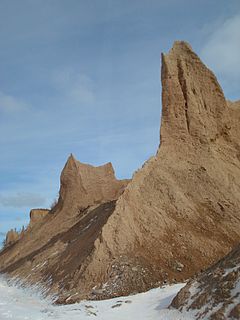
Chimney Bluffs State Park is a 597-acre (2.42 km2) state park in the town of Huron in Wayne County, New York. The park is situated on the southern shore of Lake Ontario, east of Sodus Bay. From the park's hiking trails, visitors can view the large clay formations at the water's edge for which the park is named.

Sgùrr Dearg is a mountain in the Cuillin on the Isle of Skye, Scotland. It is topped by the Inaccessible Pinnacle, a fin of rock measuring 50 metres (150 feet) along its longest edge. The top of the Inaccessible Pinnacle, which at 985.8 m (3,234 ft) is the highest point of Sgùrr Dearg and the only Munro with a peak that can only be reached by rock climbing. This makes it the biggest hurdle for many Munro baggers.
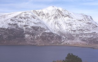
Liathach is a mountain in the Torridon Hills. At a height of 3,461 feet (1,055 m), it lies to the north of the A896 road, in the Northwest Highlands of Scotland, and has two peaks of Munro status: Spidean a' Choire Lèith at the east of the main ridge, and Mullach an Rathain at the western end of the mountain. The name Liathach is pronounced [ˈʎiəhəx] in Scottish Gaelic, and means 'The grey one'. When seen from the roadside below, its slopes appear to rise up in a series of near vertical rocky terraces.
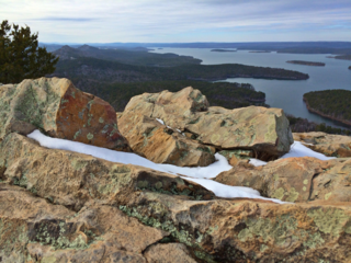
Pinnacle Mountain State Park is a 2,356-acre state park located in Pulaski County, Arkansas just outside of Little Rock. The main attraction is Pinnacle Mountain, an iconic landmark surrounded by the bottomlands of the Big Maumelle and Little Maumelle rivers.

Pinnacle State Park and Golf Course is a 714-acre (2.89 km2) state park located in Steuben County, New York. The park is southwest of the City of Corning in the Town of Addison, east of Village of Addison.
Pinnacles Provincial Park is a provincial park in British Columbia, Canada, located just west of Quesnel, north of Baker Creek.

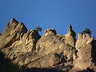
Pinnacle Peak is a granite summit located in Scottsdale, Arizona. The peak rises to an elevation of 3,169 feet (966 m). It is located within the 150-acre (61 ha) Pinnacle Peak Park, operated by the City of Scottsdale Park District. Part of the Sonoran Desert, the park is home to a variety of native desert flora and fauna. Hikers utilize a 1.75 mile trail to explore the area, though rock climbing skills are needed to reach the summit.
Honwee Mountain, east summit 2,313 feet (705 m) and west summit 2,280 feet (690 m), is a prominent mountain in the Taconic Mountains of western Massachusetts. The mountain is located in Pittsfield State Forest. The east (highest) summit is traversed by the Honwee Circuit multi-use trail. The west summit is crossed by the 35 mi (56 km) Taconic Crest hiking trail and the 12.1 mi (19.5 km) multi-use Taconic Skyline Trail. The mountain is wooded with northern hardwood forest species.
The Church at Pinnacle Hills is a campus of the First Baptist Church of Springdale, located in Rogers, Arkansas. It is located twenty minutes north of the Springdale campus. This location was launched in 2001 by approximately 350 members of the Springdale campus under the direction of senior pastor Dr. Ronnie Floyd. It is the largest church in the state of Arkansas, with a membership of over 16,000.
Peshastin Pinnacles State Park is a 34-acre (14 ha) public recreation area located three miles (4.8 km) northwest of Cashmere in Chelan County, Washington. The state park features sandstone slabs and spires in a desert environment with views of the surrounding orchards, Enchantment Range, and Wenatchee Valley. Park activities include rock climbing, hiking, birdwatching, and wildlife viewing.

Kohojकोहोज किल्ला is a medieval military fortification located near Palghar in Palghar district in Maharashtra, India.

Pinnacle Hills Promenade is a retail lifestyle center in Rogers, Arkansas. Opened in 2006, it features Cabela's, Dillard's, J. C. Penney, Target, and Best Buy as its anchor stores. It also includes a Malco Theatres movie theater. Adjacent to the mall is a power center, Pinnacle Hills Crossing, which features several big box stores.
Scenic Brook is a neighborhood located in southwest Austin, Texas. Scenic Brook is located in ZIP codes 78735 and 78736. The boundaries are the intersections of Highway 290 and Highway 71 to on the north, south, and east sides, and Covered Bridge Drive and Scenic Brook Drive on the west side. The Pinnacle Campus of Austin Community College is a landmark on the southeast side of the neighborhood.

Selbari is a mountain range located in Nashik District in Maharashtra, India. Spanning east-west the hills form the northernmost extent of the Sahyadris and serve as a natural boundary between Nashik District and Dhule district. The range is gifted with a number of peaks including the only two-pinnacled peak of Mangi-Tungi rising to a considerable height of up to 1,331 meters.

The Statue of Ahimsa is located at Mangi-Tungi, in Nashik, in the Indian state of Maharashtra. It is the tallest Jain statue in the world. The statue depicts the first Jain Tirthankara, Rishabhanatha. The statue is 108 feet tall – 121 feet including pedestal. The statue has been carved out of the Mangi-Tungi hills, which are considered to be sacred by the Jains. This statue holds the Guinness world record for the tallest Jain Idol. The certificate was awarded to Ganini Gyanmati Mataji, Chandnamati Mataji and Swami Ravindrakirtiji on 6 March 2016.

The Pinnacle is a Canadian peak in the Cape Breton Highlands, with an elevation of 530 metres (1,740 ft). The Pinnacle is the second highest elevation point in the province of Nova Scotia, and the highest in Inverness County, Nova Scotia..

Ashland Pinnacle is a pillar in Greene County, New York. It is located in the Catskill Mountains north-northeast of Ashland. The Knob is located south, and Huntersfield Mountain is located west of Ashland Pinnacle.

