East Hollywood is a densely populated neighborhood with approximately 78,000 residents that is part of the Hollywood area of the central region of Los Angeles, California. Among sites in East Hollywood are Los Angeles City College, Barnsdall Art Park, seven public and five private schools; a Los Angeles Public Library branch, and three hospitals. Almost two-thirds of the people living there were born outside the United States and 90% are renters. According to the 2000 census, the neighborhood has high percentages of people who had never married and single parents.
In the early 20th century, the East Hollywood area was a farming village which also encompasses some of what is now Los Feliz. Some of the neighborhood was formerly known as Prospect Park. In 1910, the towns of Hollywood and East Hollywood approved annexation to the City of Los Angeles in order to tap into the city water supply. In 1914, Children's Hospital was moved from downtown L.A. to Vermont Avenue and Sunset Boulevard.[citation needed]
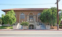
Cahuenga Branch, Los Angeles Public Library
In 1916 steel magnate Andrew Carnegie donated the money to construct the Cahuenga Branch of the Los Angeles Public Library on Santa Monica Boulevard.[2] In the early 1920s, Barnsdall Park was built. The 1920s was also a time of massive immigration into East Hollywood. Armenian immigrants established the community which is now Little Armenia. The University of California Southern Branch, needing more space, moved west at the end of the 1920s to a ranch called Westwood and became UCLA. The old Southern Branch campus became Los Angeles Junior College which was later renamed Los Angeles City College.[citation needed]
The 2000 U.S. census counted 73,967 residents in the 2.38-square-mile East Hollywood neighborhood—or 31,095 people per square mile, the third-highest population density in the city. In 2008, the city estimated that the population had increased to 78,192 - or 32,853 people per square mile. In 2000 the median age for residents was 31, about average for city and county neighborhoods; the percentage of residents aged 19 to 34 was among the county's highest.[3]
The neighborhood was "moderately diverse" ethnically within Los Angeles, the statistics being Latino people of any race, 60.4%; Asians, 15.5%; non-Hispanic Whites, 17.5%; blacks, 2.4%; and others, 4.1%. El Salvador (21.2%) and Mexico (20.1%) were the most common places of birth for the 66.5% of the residents who were born abroad—which was a high percentage compared to Los Angeles as a whole.[3]
The median yearly household income in 2008 dollars was $29,927, considered low for the city, and high percentages of households earned $40,000 or less. Renters occupied 91.3% of the housing stock, and house-or apartment-owners held 8.7%. The average household size of three people was average for Los Angeles. The percentages of never-married women (33.3%) and men (42.6%) were among the county's highest. One-fifth of the 3,281 families were headed by single parents, a high rate for Los Angeles.[3] In 2000 there were 1,509 veterans, or 2.8% of the population, a low rate compared with the rest of the city and county.[3]
Homeless population
In 2022, there were 528 homeless people in East Hollywood.[4]
Geography
East Hollywood Neighborhood Council
According to The East Hollywood Neighborhood Council, East Hollywood is bounded by Western Avenue on the west, Hollywood Boulevard on the north, Hoover Street on the east, and the Hollywood Freeway on the south.[5] It contains these districts:
According to the Times, East Hollywood includes the smaller neighborhoods of Thai Town, Little Armenia, and Melrose Hill.[3] However, Melrose Hill is located south of the Hollywood Freeway and outside the boundaries set by The East Hollywood Neighborhood Council.[6] (Melrose Hill is within the Hollywood Studio District Neighborhood Council.)[7] Additionally, the Times does not mention Virgil Village, but the neighborhood is within the boundaries set by the Times.
Transportation
Vermont Ave. and Sunset Bl. intersection, Children's Hospital in the background
Thirteen percent of East Hollywood residents aged 25 and older had earned a four-year degree by 2000, an average figure for the city and the county, but the percentage of residents with less than a high school diploma was high for the county.[3]
↑Murphy, Annie (January 28, 2020). "Helping Everyone to Help Themselves - Andrew Carnegie and Libraries". Photo Friends. Los Angeles Public Library. Retrieved August 8, 2024. The Cahuenga Branch Library of the Los Angeles Public Library (situated on Santa Monica Boulevard in East Hollywood) was built in 1916 with a $35,000 grant ($820,400 in today's economy) from Andrew Carnegie.
This page is based on this Wikipedia article Text is available under the CC BY-SA 4.0 license; additional terms may apply. Images, videos and audio are available under their respective licenses.