Elanora, Queensland

Last updated

Elanora
Gold Coast,  Queensland
Seaview Parade, Elanora, Queensland.jpg
Seaview Parade, 2015
Gold Coast locator map.svg
Red pog.svg
Elanora
Elanora, Queensland
Coordinates 28°07′58″S153°26′59″E / 28.1327°S 153.4497°E / -28.1327; 153.4497 (Elanora (centre of suburb))
Population12,539 (2021 census) [1]
 • Density1,409/km2 (3,649/sq mi)
Established1922
Postcode(s) 4221
Elevation18 m (59 ft)
Area8.9 km2 (3.4 sq mi)
Time zone AEST (UTC+10:00)
Location
LGA(s) City of Gold Coast
State electorate(s) Currumbin
Federal division(s) McPherson
Suburbs around Elanora:
Tallebudgera Burleigh Heads Palm Beach
Tallebudgera Elanora Currumbin Waters
Tallebudgera Currumbin Valley Currumbin Waters

Elanora is a suburb of the City of Gold Coast in Queensland, Australia. [2] In the 2021 census, Elanora had a population of 12,539 people. [1]

Contents

Geography

Pine trees in Elanora Walk through the Pines (14147894889).jpg
Pine trees in Elanora

Elanora is located between Tallebudgera Creek and Currumbin Creek, 13 kilometres (8 mi) west-north-west of the coastal border town of Coolangatta and 94 kilometres (58 mi) south-southeast of Brisbane, the state capital. Its local government area is the City of Gold Coast.[ citation needed ]

Elanora is bounded by Tallebudgera Creek to the northwest, Pacific Motorway to the northeast and east, and Guineas Creek and Simpsons Roads to the southeast. [3] It contains Elanora State High School, Elanora Primary School and a small neighbourhood shopping centre on Nineteenth Avenue, and The Pines, a larger shopping centre on Guineas Creek Road. Elanora also has a large public library. Under the Queensland Government proposal to extend the Gold Coast railway line, a station at Elanora, near The Pines Shopping Centre has been proposed.[ citation needed ]

History

The name Elanora is an Aboriginal word for "home by the sea", was originally named as a railway station on the South Coast Rail Line in 1922. [2] [4]

Elanora Post Office opened 2 May 1927. [4]

Elanora State School opened in January 1983. [5]

Following the amalgamation that created the Uniting Church in Australia in 1977, the Palm Beach Methodist Church, Currumbin Valley Presbyterian Valley and Tallebudgera Presbyterian Church merged to form a single congregation, establishing a new Elanora Uniting Church in 1983. [6]

Elanora State High School opened on 29 January 1990. [5]

Elanora Branch Library opened in 2007 next to The Pines Shopping Centre. [7]

Demographics

In the 2006 census, Elanora had a population of 11,681 people. [8]

In the 2011 census, Elanora recorded a population of 11,645 people, 51.9% female and 48.1% male. The median age of the Elanora population was 41 years, 4 years above the national median of 37. 76.6% of people living in Elanora were born in Australia. The other top responses for country of birth were England 6.3%, New Zealand 5%, South Africa 1%, Scotland 0.7%, Germany 0.5%. 91.7% of people spoke only English at home; the next most common languages were 0.5% German, 0.5% Japanese, 0.4% Italian, 0.4% [9] Spanish, 0.3% Serbian. [9]

In the 2016 census, Elanora had a population of 12,145. [10]

In the 2021 census, Elanora had a population of 12,539 people. [1]

Education

Elanora State School is a government primary (Preparatory to Year 6) school for boys and girls at K P McGrath Drive ( 28°07′51″S153°28′01″E / 28.1307°S 153.4670°E / -28.1307; 153.4670 (Elanora State School) ). [11] [12] In 2017, the school had an enrolment of 1,033 students with 77 teachers (67 full-time equivalent) and 34 non-teaching staff (26 full-time equivalent). [13] It includes a special education program. [11] [14]

Elanora State High School is a government secondary (7–12) school for boys and girls on the corner 19th Avenue and Avocado Street ( 28°07′42″S153°26′58″E / 28.1284°S 153.4495°E / -28.1284; 153.4495 (Elanora State High School) ). [11] [15] In 2017, the school had an enrolment of 933 students with 82 teachers (75 full-time equivalent) and 49 non-teaching staff (32 full-time equivalent). [13] It includes a special education program. [11] [16]

Amenities

Gold Coast City Council operates Elanora Branch Library in The Pines Shopping Centre, Guineas Creek Road. [17]

Elanora Uniting Church is at 17 Applecross Way ( 28°07′36″S153°27′54″E / 28.1268°S 153.4651°E / -28.1268; 153.4651 (Elanora Uniting Church) ). [18] [19] [20]

Politics

Elanora is held under the Federal Seat; Division of McPherson. The incumbent member for parliament is Liberal Party member Karen Andrews. In the Queensland Legislative Assembly the suburb is represented by Liberal Party member Laura Gerber. In the Local Government, Gold Coast City Council, Elanora is divided into two divisions: Division 13 and Division 14. Division 13 is represented by Cr Josh Martin and Division 14 is represented by Cr Gail O'Neill. [21]

Related Research Articles

<span class="mw-page-title-main">Mooloolaba</span> Suburb of Maroochydore, Queensland, Australia

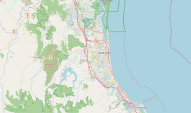
Mooloolaba is a coastal suburb of Maroochydore in the Sunshine Coast Region, Queensland, Australia. It is located 97 kilometres (60 mi) north of the state capital, Brisbane, and is part of the Maroochydore urban centre.

<span class="mw-page-title-main">Coolangatta</span> Suburb of Gold Coast, Queensland, Australia

Coolangatta is a coastal suburb in the City of Gold Coast, Queensland, Australia. It is the Gold Coast's southernmost suburb and it borders New South Wales. In the 2021 census, Coolangatta had a population of 6,491 people.

<span class="mw-page-title-main">Burleigh Heads, Queensland</span> Suburb of Gold Coast, Queensland, Australia

Burleigh Heads is a coastal suburb in the City of Gold Coast, Queensland, Australia. In the 2016 census, Burleigh Heads had a population of 10,077 people.

<span class="mw-page-title-main">Currumbin, Queensland</span> Suburb of Gold Coast, Queensland, Australia

Currumbin is a coastal suburb in the City of Gold Coast, Queensland, Australia. In the 2021 census, Currumbin had a population of 3,278 people.

<span class="mw-page-title-main">Mudgeeraba, Queensland</span> Town in Queensland, Australia

Mudgeeraba is a town and suburb in the City of Gold Coast, Queensland, Australia. In the 2021 census, the suburb of Mudgeeraba had a population of 14,578 people. Mudgeeraba's essential character remains one of a nineteenth-century village.

<span class="mw-page-title-main">Palm Beach, Queensland</span> Suburb of Gold Coast, Queensland, Australia

Palm Beach is a coastal suburb in the City of Gold Coast, Queensland, Australia. In the 2021 census, Palm Beach had a population of 16,349 people.

<span class="mw-page-title-main">Buderim</span> Town in Queensland, Australia

Buderim is a town in the Sunshine Coast Region, Queensland, Australia. It sits on a 180-metre (590 ft) mountain which overlooks the southern Sunshine Coast communities.

<span class="mw-page-title-main">Landsborough, Queensland</span> Town in Queensland, Australia

Landsborough is a town and a locality in the Sunshine Coast Region, Queensland, Australia. In the 2021 census, the locality of Landsborough had a population of 4,446 people.

<span class="mw-page-title-main">Ashmore, Queensland</span> Suburb of Gold Coast, Queensland, Australia

Ashmore is a suburb of the City of Gold Coast, Queensland, Australia. In the 2021 census, Ashmore had a population of 12,415 people.

<span class="mw-page-title-main">Canungra, Queensland</span> Town in Queensland, Australia

Canungra is a rural town and locality in the Scenic Rim Region of South East Queensland, Australia. In the 2021 census, Canungra had a population of 1,436 people.

<span class="mw-page-title-main">Beachmere, Queensland</span> Town in Queensland, Australia

Beachmere is a coastal rural town and locality in the City of Moreton Bay, Queensland, Australia. In the 2021 census, the locality of Beachmere had a population of 4,782 people.

Runaway Bay is a coastal suburb in the City of Gold Coast, Queensland, Australia. In the 2021 census, Runaway Bay had a population of 9,308 people.

<span class="mw-page-title-main">Arundel, Queensland</span> Suburb of Gold Coast, Queensland, Australia

Arundel is a suburb in the City of Gold Coast, Queensland, Australia. In the 2021 census, Arundel had a population of 11,171 people.

<span class="mw-page-title-main">Tallebudgera, Queensland</span> Suburb of Gold Coast, Queensland, Australia

Tallebudgera is a suburb in the City of Gold Coast, Queensland, Australia. In the 2021 census, Tallebudgera had a population of 3,826 people.

<span class="mw-page-title-main">Coomera, Queensland</span> Town in Queensland, Australia

Coomera is a town and suburb in the City of Gold Coast, Queensland, Australia. In the 2021 census, the suburb of Coomera had a population of 20,225 people.

<span class="mw-page-title-main">Gilston, Queensland</span> Suburb of City of Gold Coast, Queensland, Australia

Gilston is a rural residential locality in the City of Gold Coast, Queensland, Australia. In the 2021 census, Gilston had a population of 2,669 people.

<span class="mw-page-title-main">Cedar Creek, Queensland (Logan & Gold Coast)</span> Suburb of City of Gold Coast, Queensland, Australia

Cedar Creek is a locality split between City of Gold Coast and Logan City in Queensland, Australia. In the 2021 census, Cedar Creek had a population of 861 people.

<span class="mw-page-title-main">Currumbin Valley, Queensland</span> Suburb of Gold Coast City, Queensland, Australia

Currumbin Valley is a rural locality in the City of Gold Coast, Queensland, Australia. It borders New South Wales. In the 2021 census, Currumbin Valley had a population of 2,084 people.

<span class="mw-page-title-main">Currumbin Waters, Queensland</span> Suburb of Gold Coast City, Queensland, Australia

Currumbin Waters is a suburb in the City of Gold Coast, Queensland, Australia. It borders New South Wales. In the 2021 census, Currumbin Waters had a population of 9,797 people.

<span class="mw-page-title-main">Tallebudgera Valley, Queensland</span> Suburb of Gold Coast, Queensland, Australia

Tallebudgera Valley is an outer locality in the City of Gold Coast, Queensland, Australia. It borders New South Wales. In the 2021 census, Tallebudgera Valley had a population of 1,762 people.

References

  1. 1 2 3 Australian Bureau of Statistics (28 June 2022). "Elanora (SAL)". 2021 Census QuickStats. Retrieved 28 February 2023. OOjs UI icon edit-ltr-progressive.svg
  2. 1 2 "Elanora – suburb in City of Gold Coast (entry 46046)". Queensland Place Names. Queensland Government . Retrieved 26 January 2020.
  3. Ausway (2005). Brisway Street Directory (1 ed.). pp. Maps 829–830. ISBN   0-909439-10-9.
  4. 1 2 Gold Coast City (31 December 2004). "Heritage Tour - Elanora". Archived from the original on 30 June 2007. Retrieved 8 June 2007.
  5. 1 2 Queensland Family History Society (2010), Queensland schools past and present (Version 1.01 ed.), Queensland Family History Society, ISBN   978-1-921171-26-0
  6. "History". Elanora Uniting Church. Archived from the original on 12 September 2021. Retrieved 15 September 2021.
  7. "Public Libraries Statistical Bulletin 2016-17" (PDF). Public Libraries Connect. State Library of Queensland. November 2017. p. 13. Archived (PDF) from the original on 30 January 2018. Retrieved 24 January 2018.
  8. Australian Bureau of Statistics (25 October 2007). "Elanora, Queensland (SSC)". 2006 Census QuickStats. Retrieved 3 June 2024.
  9. 1 2 Australian Bureau of Statistics (31 October 2012). "Elanora, Queensland". 2011 Census QuickStats. Retrieved 22 November 2015. OOjs UI icon edit-ltr-progressive.svg
  10. Australian Bureau of Statistics (27 June 2017). "Elanora (Qld.) (State Suburb)". 2016 Census QuickStats. Retrieved 25 January 2018. OOjs UI icon edit-ltr-progressive.svg
  11. 1 2 3 4 "State and non-state school details". Queensland Government. 9 July 2018. Archived from the original on 21 November 2018. Retrieved 21 November 2018.
  12. "Elanora State School". Archived from the original on 13 March 2020. Retrieved 21 November 2018.
  13. 1 2 "ACARA School Profile 2017". Archived from the original on 22 November 2018. Retrieved 22 November 2018.
  14. "Elanora SS - Special Education Program". Archived from the original on 13 March 2020. Retrieved 21 November 2018.
  15. "Elanora State High School". Archived from the original on 3 August 2019. Retrieved 21 November 2018.
  16. "Elanora SHS - Special Education Program". Archived from the original on 3 August 2019. Retrieved 21 November 2018.
  17. "Elanora Branch Library". Public Libraries Connect. State Library of Queensland. 15 September 2015. Archived from the original on 24 January 2018. Retrieved 24 January 2018.
  18. "Find a Church". Uniting Church in Australia, Queensland Synod. Archived from the original on 24 October 2020. Retrieved 22 November 2020.
  19. "Welcome to Elanora Uniting Church". Elanora Uniting Church. Archived from the original on 21 September 2010. Retrieved 15 September 2021.
  20. "Elanora Uniting Church". Churches Australia. Archived from the original on 15 September 2021. Retrieved 15 September 2021.
  21. "Mayor & Councillors". www.goldcoast.qld.gov.au. Retrieved 13 May 2024.