
The Aboriginal Tasmanians are the Aboriginal people of the Australian island of Tasmania, located south of the mainland. For much of the 20th century, the Tasmanian Aboriginal people were widely, and erroneously, thought of as being an extinct cultural and ethnic group that had been intentionally exterminated by white settlers. Contemporary figures (2016) for the number of people of Tasmanian Aboriginal descent vary according to the criteria used to determine this identity, ranging from 6,000 to over 23,000.

George Town is a large town in north-east Tasmania, on the eastern bank of the mouth of the Tamar River. The Australian Bureau of Statistics records the George Town Municipal Area had a population of 6,764 as of 30 June 2016.

The Tasmanian languages were the languages indigenous to the island of Tasmania, used by Aboriginal Tasmanians. The languages were last used for daily communication in the 1830s, although the terminal speaker, Fanny Cochrane Smith, survived until 1905.
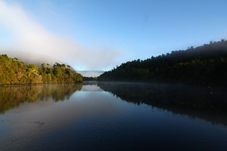
The Pieman River is a major perennial river located in the west coast region of Tasmania, Australia.
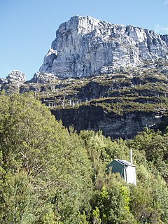
Frenchmans Cap is a mountain in the West Coast region of Tasmania, Australia. The mountain is situated in the Franklin-Gordon Wild Rivers National Park.

Ben Lomond is a mountain in the north-east of Tasmania, Australia.

Deddington is a rural locality in the local government area (LGA) of Northern Midlands in the Central LGA region of Tasmania. The locality is about 34 kilometres (21 mi) east of the town of Longford. The 2016 census has a population of 121 for the state suburb of Deddington. The town is situated on the Nile River and lies in the foothills of Ben Lomond.
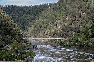
The South Esk River, the longest river in Tasmania, is a major perennial river located in the northern region of Tasmania, Australia.

The North Esk River is a major perennial river located in the northern region of Tasmania, Australia.

Evandale is an historic town in northern Tasmania, Australia. It sits on the banks of the South Esk River, 18 km south of Launceston. Named after early colonial explorer and Surveyor-General George Evans, the town is famous for its late-Georgian and early-Victorian buildings with relatively untouched streetscape, a popular Sunday market and as a host to the annual World Penny Farthing bicycle Championships. At the 2016 census, Evandale had a population of 1,345.
Ross is a village in the Midlands of the state of Tasmania in Australia. On the Macquarie River, Ross is located 78 km south of Launceston and 117 km north of Hobart. The town is listed on the Register of the National Estate and is noted for its historic bridge, original sandstone buildings and convict history.

Campbell Town is a town in Tasmania, Australia, on the Midland Highway. At the 2006 census, the town had a population of 772.

The Macquarie River is a major perennial river located in the Midlands region of Tasmania, Australia.
Palawa kani is a constructed language created by the Tasmanian Aboriginal Centre as a composite Tasmanian language, based on reconstructed vocabulary from the limited accounts of the various languages once spoken by the eastern Aboriginal Tasmanians. The centre wishes to keep the language private until it is established in the community and claims copyright. The United Nations Declaration on the Rights of Indigenous Peoples (UNDRIP) outlines that indigenous people should have the right to control their own cultural knowledge, including languages. However, languages cannot get copyright under Australian or international law.

The Stacks Bluff is a peak in northeast Tasmania, Australia. The mountain is situated on the Ben Lomond plateau.
The Liffey Valley Reserve is a nature reserve comprising four separate parcels of land, with a combined area of 275 ha, in the Liffey Valley of northern Tasmania, Australia. It lies about 55 km (34 mi) south-west of Launceston and 25 km (16 mi) south-east of Deloraine. It is owned and managed by Bush Heritage Australia (BHA).

Mount Barrow is a mountain in the northern region of Tasmania, Australia. With an elevation of 1,406 metres (4,613 ft) above sea level, the mountain is located 22 kilometres (14 mi) east-north-east of Launceston. The mountain habitat is a mixture of temperate old growth rainforest, subalpine and alpine landscapes.
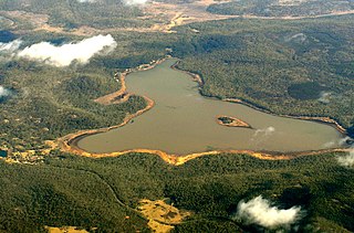
Lake Leake is the name of both a man-made water storage reservoir and a small township in the eastern midlands of Tasmania. The locality is split between two local authorities, as follows:

Tooms Lake is a rural locality and a lake in the local government areas (LGA) of Northern Midlands, Southern Midlands, and Glamorgan-Spring Bay in the Central and South-east LGA regions of Tasmania. The locality is about 47 kilometres (29 mi) north of the town of Triabunna. The 2016 census has a population of nil for the state suburb of Tooms Lake.

The Roving Party is a 2011 novel written by Tasmanian author Rohan Wilson. Wilson's first book, it is published by Allen & Unwin. The Roving Party won the 2011 Vogel Award. The novel was also shortlisted for the 2011 Victorian Premier's Literary Awards Vance Palmer Prize for Fiction.

