Ellendale, St. Louis

Last updated

Ellendale
Ellendale Intersection (7398758898).jpg
Ellendale homes, June 2012
STL Neighborhood Map 10.PNG
Location (red) of Ellendale within St. Louis
Country United States
State Missouri
City St. Louis
Wards 23, 24
Area
  Total
0.83 sq mi (2.1 km2)
Population
 (2020) [1]
  Total
1,385
  Density1,700/sq mi (640/km2)
ZIP code(s)
Parts of 63139, 63143
Area code(s) 314
Website stlouis-mo.gov

Ellendale is a neighborhood of St. Louis, Missouri. Its eastern portion is considered a part of Dogtown, which also includes four other neighborhoods north of Manchester.

Contents

Location

Ellendale is bounded by Manchester on the North, I-44 on the south, Hampton on the East, and the City limits on the West. The neighborhood is surrounded by Lindenwood Park, Clifton Heights, The Hill, and the other "Dogtown" neighborhoods of Clayton/Tamm and Franz Park.

History

Originally, much of what is now Ellendale was land owned by James E. Sutton, who died in 1877. He bequeathed his land to his nine children. Kate Thomas, one of his daughters, started Ellendale. Although an accident destroyed much of the housing built before the World's Fair in 1904, some old homes built after the fair, mostly for the executives of Scullin Steel, are still standing. The area began to grow residentially in the last years of the century, helped along by the electric streetcars, which began running to the area in 1896.

The area was first opened to industrial activity in the 1850s because of the construction of the Pacific Railroad and the mining of clay for fire brick. Coal was also discovered, but not enough to make it a long-lasting, profitable endeavor. Scullin Steel Co. stood as a landmark in the neighborhood until it ceased production in the 1970s. The former site is now St. Louis Marketplace, located on Manchester and Abbott. The railroads still run through the area.

Originally, the River des Peres ran through the neighborhood, from its underground beginnings in Forest Park. It was converted to a drainage project, and now all that remains is the valley created by it. This valley forms the main topographical characteristic of the neighborhood.

Characteristics

Ellendale is no longer an industrial neighborhood. It is very residential, with most commercial and office space. The housing is mainly single-family units (almost 70 percent, running from small starter homes to larger dwellings. The population is fairly small, at only 1,700. Household size is fairly small, averaging only 2.3 people per household, with a majority of the households having only one or two inhabitants. The area is solidly middle-class, with a median household income at almost $24,000 and a median family income at just over $31,000. There are very few residents classified as either "poor" or "very poor".

In general, the workforce is educated, with some 30 percent of those over 25 years old having attended college. The unemployment rate is just over 6 percent. Almost two-thirds of the houses are owner-occupied, and less than 10 percent of the housing stock is currently vacant. In general, the area is very safe, with the lowest reported crime rate in the city. Transportation is easily accessible via the highway networks that run close to the neighborhood, as are shopping opportunities. For entertainment and leisure, Forest Park and the St. Louis Science Center are not far away, and the adjacent neighborhoods offer plenty of dining experiences, as well as a variety of other services, such as hospitals, shopping centers, and movie theaters.

Institutions and organizations

Ellendale itself is a small neighborhood and relies on some of the assets and resources of the surrounding communities. It does, however, have a few very important institutions. As mentioned before, the old Scullin Steel building was turned into the St. Louis Marketplace, home to a strip mall with discount shopping, as well as some chain stores. The area is still home to the Principle Union Pacific Railroad and the Burlington Northern Railroad. For residents, there is an Ellendale Neighborhood Association, which meets monthly. There is also the Wilkinson/Early Childhood Center II Magnet School, originally built in 1927.

Planning and development

There have been some effective planning in Ellendale. The conversion of the old Scullin Steel plant into retail space is one such example that shows how the area is changing with the times. In order to establish this shopping area, railroad tracks had to be diverted.

2011 chemical fire

A five-alarm chemical fire at Chemisphere Corporation occurred about 2:30 AM on Monday, June 20, 2011, according to an online news article that day by Kim Bell of the Saint Louis Post-Dispatch. The fire forced hundreds of people from their homes, shut down an interstate and brought hazardous materials teams to the scene. The fire was spotted by people driving along Interstate 44. The plant is in the 2100 block of Cliffton Avenue. Flames were shooting into the air, and an orange glow and smoke could be seen for miles. By 7:00 AM, most of the 500 residents who had been evacuated were allowed to return home, though they were not allowed to take their cars. Though no hazardous levels of chemicals were detected and no one aside from three firemen with minor shake injuries were injured, some people said they sensed a metallic taste in their mouths (the company has a rail spur that brings in rail cars carrying solvent-distribution products such as glycol ethers, alcohol, aliphatic hydrocarbons, alkalis, aromatic hydrocarbons, chlorinated solvents, acids, glycol ether esters, surfactants, glycols and glycerins, plasticizers and esters). [2]

Demographics

Historical population
CensusPop.Note
1990 1,701
2000 1,656−2.6%
2010 1,575−4.9%
2020 1,385−12.1%
Sources: [3] [4]

In 2020 Ellendale's racial makeup was 76.3% White, 10.6% Black, 0.2% Native American, 1.7% Asian, 8.4% Two or More Races, and 2.5% Some Other Race. 4.3% of the population was of Hispanic or Latino origin. [5]

See also

Related Research Articles

<span class="mw-page-title-main">Ether</span> Organic compounds made of alkyl/aryl groups bound to oxygen (R–O–R)

In organic chemistry, ethers are a class of compounds that contain an ether group—a single oxygen atom bonded to two separate carbon atoms, each part of an organyl group. They have the general formula R−O−R′, where R and R′ represent the organyl groups. Ethers can again be classified into two varieties: if the organyl groups are the same on both sides of the oxygen atom, then it is a simple or symmetrical ether, whereas if they are different, the ethers are called mixed or unsymmetrical ethers. A typical example of the first group is the solvent and anaesthetic diethyl ether, commonly referred to simply as "ether". Ethers are common in organic chemistry and even more prevalent in biochemistry, as they are common linkages in carbohydrates and lignin.

<span class="mw-page-title-main">Solvent</span> Substance dissolving a solute resulting in a solution

A solvent is a substance that dissolves a solute, resulting in a solution. A solvent is usually a liquid but can also be a solid, a gas, or a supercritical fluid. Water is a solvent for polar molecules, and the most common solvent used by living things; all the ions and proteins in a cell are dissolved in water within the cell.

<span class="mw-page-title-main">Petrochemical</span> Chemical product derived from petroleum

Petrochemicals are the chemical products obtained from petroleum by refining. Some chemical compounds made from petroleum are also obtained from other fossil fuels, such as coal or natural gas, or renewable sources such as maize, palm fruit or sugar cane.

<span class="mw-page-title-main">Ellendale, Delaware</span> Town in Delaware, United States

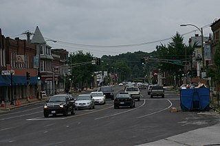
Ellendale is a town in Sussex County, Delaware, United States. The population was 487 at the 2020 census, an increase of 27.8% since the 2010 census, and a 48.9% increase since the year 2000. It is part of the Salisbury, Maryland-Delaware Metropolitan Statistical Area. Ellendale is the "Gateway to Delaware's Resort Beaches" because it is the town located on U.S. Route 113, the resort area's westernmost border, and Delaware Route 16, the resort area's northernmost border with the eastern border being the Delaware Bay and Atlantic Ocean and the southern border being the state line with Maryland.

<span class="mw-page-title-main">Manchester, New Hampshire</span> Largest city in New Hampshire, US

Manchester is the most populous city in the U.S. state of New Hampshire and the tenth most populous in New England. As of the 2020 census, it had a population of 115,644. Manchester is a major city within the boundaries of the Greater Boston, Massachusetts Metropolitan Area.

<span class="mw-page-title-main">Dry cleaning</span> Cleaning of fabrics in non-aqueous solvents

Dry cleaning is any cleaning process for clothing and textiles using a solvent other than water. Clothes are instead soaked in a water-free liquid solvent. Perchloroethylene is the most commonly used solvent, although alternative solvents such as hydrocarbons, and supercritical CO2 are also used.

A paint thinner is a solvent used to dilute oil-based paints or varnish. In this context, to dilute is also known as to 'thin'. Paint thinners are diluents. Solvents labeled "paint thinner" are usually white or mineral spirits.

<span class="mw-page-title-main">South Deering, Chicago</span> Community area in Chicago

South Deering, located on Chicago's far South Side, is the largest of the 77 official community areas of that city. Primarily an industrial area, a small residential neighborhood exists in the northeast corner and Lake Calumet takes up a large portion of the area. 80% of the community area is zoned as industrial, natural wetlands, or parks. The remaining 20% is zoned for residential and small-scale commercial uses. It is part of the 10th Ward, once under the control of former Richard J. Daley ally Alderman Edward Vrdolyak.

<span class="mw-page-title-main">2-Butoxyethanol</span> Chemical compound

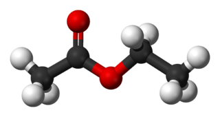
2-Butoxyethanol is an organic compound with the chemical formula BuOC2H4OH. This colorless liquid has a sweet, ether-like odor, as it derives from the family of glycol ethers, and is a butyl ether of ethylene glycol. As a relatively nonvolatile, inexpensive solvent, it is used in many domestic and industrial products because of its properties as a surfactant. It is a known respiratory irritant and can be acutely toxic, but animal studies did not find it to be mutagenic, and no studies suggest it is a human carcinogen. A study of 13 classroom air contaminants conducted in Portugal reported a statistically significant association with increased rates of nasal obstruction and a positive association below the level of statistical significance with a higher risk of obese asthma and increased body mass index.

<span class="mw-page-title-main">Pigtown, Baltimore</span> Neighborhood in southwest Baltimore

Pigtown is a neighborhood in the southwest area of Baltimore, bordered by Martin Luther King Jr. Boulevard to the east, Monroe Street to the west, Russell Street to the south, and West Pratt Street to the north. The neighborhood acquired its name during the second half of the 19th century, when the area was the site of butcher shops and meat packing plants to process pigs transported from the Midwest on the B&O Railroad; they were herded across Ostend and Cross Streets to be slaughtered and processed.

<i>tert</i>-Butyllithium Chemical compound

tert-Butyllithium is a chemical compound with the formula (CH3)3CLi. As an organolithium compound, it has applications in organic synthesis since it is a strong base, capable of deprotonating many carbon molecules, including benzene. tert-Butyllithium is available commercially as solutions in hydrocarbons (such as pentane); it is not usually prepared in the laboratory.

<span class="mw-page-title-main">Firefighting foam</span> Foam used for fire suppression

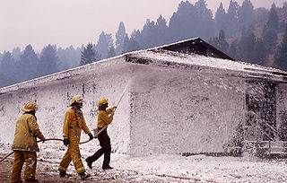
Firefighting foam is a foam used for fire suppression. Its role is to cool the fire and to coat the fuel, preventing its contact with oxygen, thus achieving suppression of the combustion. Firefighting foam was invented by the Moldovan engineer and chemist Aleksandr Loran in 1902.

<span class="mw-page-title-main">Baden, St. Louis</span> Neighborhood of St. Louis in Missouri, United States

Baden is a neighborhood of St. Louis, Missouri.

<span class="mw-page-title-main">Franz Park, St. Louis</span> Neighborhood of St. Louis in Missouri, United States

Franz Park is a neighborhood of St. Louis, Missouri.

<span class="mw-page-title-main">Hamilton Heights, St. Louis</span> Neighborhood of St. Louis in Missouri, United States

Hamilton Heights is a neighborhood of St. Louis, Missouri. The neighborhood is bounded by Dr. Martin Luther King Drive on the Northeast, the city limits on the Northwest, Page Avenue on the South, and Union Boulevard on the East.

<span class="mw-page-title-main">Hi-Pointe, St. Louis</span> Neighborhood of St. Louis in Missouri, United States

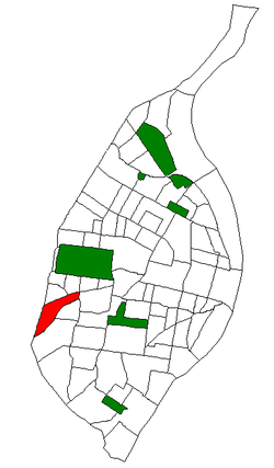
Hi-Pointe is a neighborhood of St. Louis, Missouri, within a section known as Dogtown. It is bounded by Clayton Avenue and Oakland Avenue on the north, City Limits on the west, Dale Avenue on the south, and Louisville Avenue on the east. It is bordered by the Skinker-DeBaliviere neighborhood and Forest Park on the north, the Clayton-Tamm neighborhood on the east, the Franz Park neighborhood on the south and the city of Richmond Heights, part of St. Louis County on the west.

<span class="mw-page-title-main">Frogtown, Saint Paul, Minnesota</span> Neighborhood in Ramsey, Minnesota, United States

Frogtown is a neighborhood in Saint Paul in the U.S. state of Minnesota. Built around University Avenue, the Thomas-Dale neighborhood is colloquially known as Frogtown. Historically, Frogtown was a subsection of the current Thomas-Dale neighborhood. It is bordered by University Avenue on the south, the Burlington Northern Railroad tracks to the north, Lexington Parkway on the west and Rice Street on the east.

<span class="mw-page-title-main">Dogtown, St. Louis</span> Section of St. Louis, Missouri

Dogtown is a traditionally Irish section of St. Louis, Missouri. It is located south of Forest Park, with its southeastern edge abutting the traditionally Italian section of town, The Hill neighborhood. The neighborhood is anchored by St. James the Greater Catholic Church.

<span class="mw-page-title-main">Clayton–Tamm, St. Louis</span> Neighborhood of St. Louis in Missouri, United States

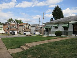
Clayton–Tamm is a historic St Louis neighborhood and once an Irish-American enclave located near the western border of St. Louis, Missouri, USA, just south of Forest Park.

<span class="mw-page-title-main">BTX (chemistry)</span> Mixtures of benzene, toluene, and the three xylene isomers

In the petroleum refining and petrochemical industries, the initialism BTX refers to mixtures of benzene, toluene, and the three xylene isomers, all of which are aromatic hydrocarbons. The xylene isomers are distinguished by the designations ortho –, meta –, and para – as indicated in the adjacent diagram. If ethylbenzene is included, the mixture is sometimes referred to as BTEX.

References

  1. "2020 Census Neighborhood Results".
  2. "Residents allowed back home after chemical fire at St. Louis business | Metro | stltoday.com". 20 June 2011.
  3. "Ellendale Neighborhood Statistics". St Louis, MO. Retrieved 26 January 2023.
  4. "Neighborhood Census Data". City of St. Louis. Retrieved 26 January 2023.
  5. "City of St. Louis" (PDF). Retrieved 2021-09-25.

38°36′48″N90°18′21″W / 38.6133°N 90.3057°W / 38.6133; -90.3057