Farm Creek Section

Last updated
Farm Creek Section
Farm Creek Section series 2 b.jpg
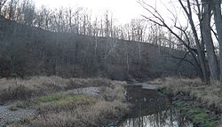
Looking downstream along Farm Creek; the geological exposure is in the eroded hillside at left.
USA Illinois location map.svg
Red pog.svg
Nearest city East Peoria, Illinois
Coordinates 40.6755°0′0″N89.4898°0′0″W / 40.67550°N 89.48980°W / 40.67550; -89.48980 Coordinates: 40.6755°0′0″N89.4898°0′0″W / 40.67550°N 89.48980°W / 40.67550; -89.48980
Area15 acres (6.1 ha)
NRHP reference No. 91002039
Significant dates
Added to NRHPFebruary 6, 1992 [1]
Designated NHLDecember 9, 1997 [2]

The Farm Creek Section, also known as the Farmdale Geologic Exposure, is a hillside near East Peoria, Illinois that clearly showed geological strata. It is nationally significant as one of the first exposed glacial stratifications in the United States to be scientifically documented. These Ice Age geological formations, with rock layers representing different periods of glaciation, had long been known and published in England, France, and Germany, but were not yet well known in North America. Geologist Frank Leverett discovered this exposed face of a hill with its clearly defined stratifications in 1879 and described and pictured it in his monograph, The Illinois Glacial Lobe, in 1899.

The Farm Creek publication gave a name to the Illinoian glaciation, the southernmost penetration of glacial ice into what was to become the Midwestern United States. It also helped formulate regional and national stratigraphic classifications and has figured prominently in the study and development of glacial geology.

A 15-acre (6.1 ha) area of the Farm Creek Section was declared a National Historic Landmark in 1997. [2] [3]

The site is on the south side of Farm Creek (a tributary of the Illinois River) in the Farm Creek Recreation Area, south of Illinois Route 8 (Washington St.) and between School Street and Bittersweet Road, and is accessible by following an unpaved road, part of which is an abandoned right of way formerly in use by the Toledo, Peoria and Western Railroad. The formation is largely covered by a modern soil layer. Some erosion has occurred in the time since its initial discovery, but the layers of strata are still readily discernible. [3]

Approximate UTM border of Farm Creek Section [3]
PointZoneEastingNorthingLongitude/Latitude
A16N2897004505760 40°40′33″N89°29′18″W / 40.67592°N 89.48828°W / 40.67592; -89.48828 (Farm Creek Section point A)
B16N2897004505620 40°40′33″N89°29′18″W / 40.67592°N 89.48828°W / 40.67592; -89.48828 (Farm Creek Section point B)
C16N2894604505640 40°40′29″N89°29′28″W / 40.67478°N 89.49108°W / 40.67478; -89.49108 (Farm Creek Section point C)
D16N2894404505820 40°40′35″N89°29′29″W / 40.67640°N 89.49138°W / 40.67640; -89.49138 (Farm Creek Section point D)

See also

Related Research Articles

Geology of the Grand Teton area

The geology of the Grand Teton area consists of some of the oldest rocks and one of the youngest mountain ranges in North America. The Teton Range, partly located in Grand Teton National Park, started to grow some 9 million years ago. An older feature, Jackson Hole, is a basin that sits aside the range.

Polystrate fossil Creationist term for a fossil that extends through more than one geological stratum

A polystrate fossil is a fossil of a single organism that extends through more than one geological stratum. This term is typically applied to "fossil forests" of upright fossil tree trunks and stumps that have been found worldwide, i.e. in the Eastern United States, Eastern Canada, England, France, Germany, and Australia, typically associated with coal-bearing strata. Within Carboniferous coal-bearing strata, it is also very common to find what are called Stigmaria within the same stratum. Stigmaria are completely absent in post-Carboniferous strata, which contain either coal, polystrate trees, or both. The word polystrate is not a standard geological term. This term is typically found in creationist publications.

The Driftless Area, a topographical and cultural region in the American Midwest, comprises southwestern Wisconsin, southeastern Minnesota, northeastern Iowa, and the extreme northwestern corner of Illinois.

Robert H. Treman State Park State park in New York, United States

Robert H. Treman State Park is a 1,110-acre (4.5 km2) state park located in Tompkins County, in the Finger Lakes region of New York in the United States. The park is situated in the towns of Ithaca, Enfield and Newfield.

The Illinoian Stage is the name used by Quaternary geologists in North America to designate the period c.191,000 to c.130,000 years ago, during the middle Pleistocene, when sediments comprising the Illinoian Glacial Lobe were deposited. It precedes the Sangamonian Stage and follows the Pre-Illinoian Stage in North America. The Illinoian Stage is defined as the period of geologic time during which the glacial tills and outwash, which comprise the bulk of the Glasford Formation, accumulated to create the Illinoian Glacial Lobe. It occurs at about the same time as the penultimate glacial period.

Great Unconformity Gap in geological strata

Of the many unconformities (gaps) observed in geological strata, the term Great Unconformity is frequently applied to either the unconformity observed by James Hutton in 1787 at Siccar Point in Scotland, or that observed by John Wesley Powell in the Grand Canyon in 1869. Both instances are exceptional examples of where the contacts between sedimentary strata and either sedimentary or crystalline strata of greatly different ages, origins, and structure represent periods of geologic time sufficiently long to raise great mountains and then erode them away.

Tinker's Creek, in Cuyahoga, Summit and Portage counties, is the largest tributary of the Cuyahoga River, providing about a third of its flow into Lake Erie.

Interstate Park United States historic place

Interstate Park comprises two adjacent state parks on the Minnesota–Wisconsin border, both named Interstate State Park. They straddle the Dalles of the St. Croix River, a deep basalt gorge with glacial potholes and other rock formations. The Wisconsin park is 1,330 acres (538 ha) and the Minnesota park is 298 acres (121 ha). The towns of Taylors Falls, Minnesota and St. Croix Falls, Wisconsin are adjacent to the park. Interstate Park is within the Saint Croix National Scenic Riverway and the Ice Age National Scientific Reserve. The western terminus of the Ice Age National Scenic Trail is on the Wisconsin side. On the Minnesota side, two areas contain National Park Service rustic style buildings and structures that are listed on the National Register of Historic Places.

Terrace (geology) A step-like landform

In geology, a terrace is a step-like landform. A terrace consists of a flat or gently sloping geomorphic surface, called a tread, that is typically bounded on one side by a steeper ascending slope, which is called a "riser" or "scarp". The tread and the steeper descending slope together constitute the terrace. Terraces can also consist of a tread bounded on all sides by a descending riser or scarp. A narrow terrace is often called a bench.

Jay Cooke State Park State park of Minnesota, United States

Jay Cooke State Park is a state park of Minnesota, United States, protecting the lower reaches of the Saint Louis River. The park is located about 10 miles (16 km) southwest of Duluth and is one of the ten most visited state parks in Minnesota. The western half of the park contains part of a rocky, 13-mile (21 km) gorge. This was a major barrier to Native Americans and early Europeans traveling by canoe, which they bypassed with the challenging Grand Portage of the St. Louis River. The river was a vital link connecting the Mississippi waterways to the west with the Great Lakes to the east.

Geology of Minnesota Overview of the geology of the U.S. state of Minnesota

The geology of Minnesota comprises the rock, minerals, and soils of the U.S. state of Minnesota, including their formation, development, distribution, and condition.

The geology of Illinois includes extensive deposits of marine sedimentary rocks from the Palaeozoic, as well as relatively minor contributions from the Mesozoic and Cenozoic. Ice age glaciation left a wealth of glacial topographic features throughout the state.

Volo Bog State Natural Area

Volo Bog State Natural Area is a nature reserve in Illinois, United States, preserving Volo Bog. The bog was designated a National Natural Landmark in 1973 as the only remaining open-water quaking bog in Illinois. The site also contains woodlands, savanna, marshes, prairie restoration areas, shrubland and old fields. Maintained by the Illinois Department of Natural Resources, the site is located about a mile west of U.S. Route 12 between the towns of Volo and Fox Lake, Illinois.

John Day Formation

The John Day Formation is a series of rock strata exposed in the Picture Gorge district of the John Day River basin and elsewhere in north-central Oregon in the United States. The Picture Gorge exposure lies east of the Blue Mountain uplift, which cuts southwest–northeast through the Horse Heaven mining district northeast of Madras. Aside from the Picture Gorge district, which defines the type, the formation is visible on the surface in two other areas: another exposure is in the Warm Springs district west of the uplift, between it and the Cascade Range, and the third is along the south side of the Ochoco Mountains. All three exposures, consisting mainly of tuffaceous sediments and pyroclastic rock rich in silica, lie unconformably between the older rocks of the Clarno Formation below and Columbia River basalts above.

Two Creeks Buried Forest State Natural Area State Natural Area in Wisconsin

Two Creeks Buried Forest State Natural Area is a site in the Wisconsin State Natural Areas Program and a unit of the Ice Age National Scientific Reserve. The site lies in the northeast corner of Manitowoc County on the shore of Lake Michigan north of Two Creeks, Wisconsin, USA. Periodically exposed in a steep lakeshore bluff is a stratum of sediment, known as the Two Creeks forest bed. It contains stumps, logs, branches, pine needles, pinecones, moss, and other forest litter and is sandwiched between layers of glacial till. This is an important site in Great Lakes geochronology because it firmly establishes the timeframe of advances and retreats during the last glacial period in this region.

Petrified Sea Gardens United States historic place

Petrified Sea Gardens, also once known as Ritchie Park, is a National Historic Landmark on Petrified Sea Gardens Road in Saratoga Springs, New York. It preserves a bed of ancient stromatolites in a Cambrian rock layer, which were the first to be recognized and understood for what they are. The site was a private park open to the public for many years, but is now closed. The site was designated a National Natural Landmark in 1967, and a National Historic Landmark in 1999.

Soldiers Home Reef United States historic place

Soldiers' Home Reef, also known as Rocky Point, National Military Asylum Reef, or Veterans' Hill is a fossilized coral reef rock formation in Milwaukee, Wisconsin. The reef formation was discovered by geologist Increase A. Lapham in the 1830s. It and other fossilized coral reefs that he discovered were the first geological reef formations described in North America, and are among the first described in the world. This reef was declared a National Historic Landmark in 1993.

Geology of Yorkshire

The Geology of Yorkshire in northern England shows a very close relationship between the major topographical areas and the geological period in which their rocks were formed. The rocks of the Pennine chain of hills in the west are of Carboniferous origin whilst those of the central vale are Permo-Triassic. The North York Moors in the north-east of the county are Jurassic in age while the Yorkshire Wolds to the south east are Cretaceous chalk uplands. The plain of Holderness and the Humberhead levels both owe their present form to the Quaternary ice ages. The strata become gradually younger from west to east.

Seaham Quarry is a heritage-listed former quarry and now geological site at Torrence Street, Seaham, Port Stephens Council, New South Wales, Australia. It was added to the New South Wales State Heritage Register on 2 April 1999.

The geology of national parks in Britain strongly influences the landscape character of each of the fifteen such areas which have been designated. There are ten national parks in England, three in Wales and two in Scotland. Ten of these were established in England and Wales in the 1950s under the provisions of the National Parks and Access to the Countryside Act 1949. With one exception, all of these first ten, together with the two Scottish parks were centred on upland or coastal areas formed from Palaeozoic rocks. The exception is the North York Moors National Park which is formed from sedimentary rocks of Jurassic age.

References

  1. "National Register Information System". National Register of Historic Places . National Park Service. January 23, 2007.
  2. 1 2 "Farm Creek Section". National Historic Landmark summary listing. National Park Service. Archived from the original on 2008-01-03. Retrieved 2007-10-08.
  3. 1 2 3 Joanne Kluessendorf and Kira Badamo (August 20, 1991). "National Historic Landmark Nomination: Farm Creek Section / Farm Creek/Farmdale Geologic Exposure" (pdf). National Park Service.{{cite journal}}: Cite journal requires |journal= (help). Accompanying 3 photos, from c.1898 and 1991.  (1.35 MB)