
The Worrall Covered Bridge, also known as the Woralls Bridge or Worral Bridge is a wooden covered bridge carrying Williams Road across the Williams River in Rockingham, Vermont, United States. Built about 1870, it is the only surviving 19th-century covered bridge in the town, after the Hall Covered Bridge collapsed in 1980 and was replaced in 1982, and the Bartonsville Covered Bridge was washed away by Hurricane Irene in 2011 and replaced in 2012-2013. The bridge was listed on the National Register of Historic Places in 1973. The bridge was damaged by the flooding on July 10, 2023, and its fate has not yet been decided.

The Ada Covered Bridge is a 125-foot (38 m) span Brown truss covered bridge erected in 1867 in Ada, Michigan, United States. Carrying Bronson Street across the Thornapple River, it is located just south of where the Thornapple enters the Grand River, in turn just south of M-21. It is listed on the National Register of Historic Places.

The Power House Covered Bridge, also known as the School Street Covered Bridge, is a covered bridge from 1872 that crosses the Gihon River off State Route 100C in Johnson, Vermont, US. It was listed on the National Register of Historic Places in 1974. The bridge's name is from a now obsolete hydroelectric generating station just upstream from it. The bridge is of Queen post truss design by an unknown builder.
The Scribner Covered Bridge, also known as the Mudgett Covered Bridge, is a covered bridge that carries Rocky Road across the Gihon River off State Route 100C in eastern Johnson, Vermont. It was listed on the National Register of Historic Places in 1974. It is one of a small number of Vermont's covered bridges that are the result of covering an existing open bridge.

The Ashuelot Covered Bridge is a historic wooden covered bridge over the Ashuelot River on Bolton Road, just south of its intersection with NH 119 in Ashuelot, an unincorporated village of Winchester, New Hampshire. Built in 1864-65, it is one of the state's few surviving 19th-century covered bridges. It was listed on the National Register of Historic Places in 1981.
The Northfield Falls Covered Bridge, also called the Station Covered Bridge, is a wooden covered bridge that carries Cox Brook Road across the Dog River in Northfield, Vermont. Built in 1872, this Town lattice truss bridge is one of five surviving covered bridges in the town, and one of two that are visible from each other. It was listed on the National Register of Historic Places in 1974.

The Slaughter HouseCovered Bridge is a wooden covered bridge that carries Slaughterhouse Road across the Dog River in Northfield, Vermont. The Queen post truss bridge is one of five surviving 19th-century bridges in the town. It was listed on the National Register of Historic Places in 1974.

The Pine Brook Covered Bridge, also called the Wilder Covered Bridge, is a wooden covered bridge that crosses Pine Brook in Waitsfield, Vermont on North Road. Built in 1872, it is one two surviving 19th-century covered bridges in the town. It was listed on the National Register of Historic Places in 1974.

The Longley Covered Bridge, also known as the Harnois Covered Bridge, is a wooden covered bridge that crosses the Trout River in Montgomery, Vermont on Longley Bridge Road. Built in 1863, this Town lattice truss bridge is the oldest of a group of area bridges built by brothers Sheldon & Savannah Jewett. It was listed on the National Register of Historic Places in 1974. The bridge is closed to traffic, and has been bypassed by an adjacent temporary bridge.

The Hammond Covered Bridge is a Town lattice covered bridge spanning Otter Creek in Pittsford, Vermont. The bridge was built in 1842 by Asa Norse, and originally carried Kendall Hill Road, which now passes just to its south. The bridge was added to the National Register of Historic Places on January 21, 1974.

The Covered Bridge in Cedarburg, Ozaukee County, Wisconsin, United States, is one of the last remaining covered bridges in that state, which once had about 40 covered bridges. Built in 1876 to cross Cedar Creek, the bridge is 120 feet (37 m) long and is made of pine with oak lattices. It was listed on the National Register of Historic Places in 1973 and is now used only for pedestrian traffic.

The Ballard Road Covered Bridge is a historic wooden covered bridge in the southwestern part of the U.S. state of Ohio. Built in the late nineteenth century and since bypassed, the bridge has been named a historic site.

Meems Bottom Covered Bridge is in Shenandoah County, Virginia, United States. The bridge, at 204 feet (62 m), is the longest covered bridge in Virginia and one of the last that supports regular traffic. Near the town of Mount Jackson, the Meems Bottom Covered Bridge features a 200-foot single-span wooden Burr arch structure. Built in 1892 by Franklin Hiser Wissler, the wooden bridge over the North Fork of the Shenandoah River provided access to his apple orchards at Strathmore Farms. The bridge was listed on the National Register of Historic Places on June 10, 1975.
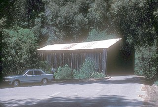
Oregon Creek Covered Bridge is a historic bridge that spans Oregon Creek just above its confluence with Middle Yuba River. It is located approximately 3 miles northeast of the community of North San Juan just off California State Route 49 within the Oregon Creek Day Use Area of the Tahoe National Forest.

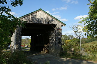
The Waterman Covered Bridge was an historic covered bridge in Johnson, Vermont that carried Waterman Road across Waterman Creek. Built in 1868, it was one of three surviving 19th-century bridges in the town. It was listed on the National Register of Historic Places in 1974, and collapsed in January 1982.

The Gorham Covered Bridge carries Gorham Bridge Road across Otter Creek in a rural area of Pittsford and Proctor, Vermont. It is a Town lattice truss bridge, built in 1841 by Abraham Owen and Nicholas M. Powers, the latter in the early stages of his career as a well-known bridgewright. The bridge was listed on the National Register of Historic Places in 1974.

Best's Covered Bridge(akaSwallow's Bridge) is a historic covered bridge in West Windsor, Vermont, that carries Churchill Road over Mill Brook, just south of Vermont Route 44. Built in 1889, it is an architecturally distinctive laminated arch structure with a post-and-beam superstructure. It was listed on the National Register of Historic Places in 1973.

The Bowers Covered Bridge(akaBrownsville Bridge) is a historic covered bridge, carrying Bible Hill Road across Mill Brook in the Brownsville section of West Windsor, Vermont. Built in 1919, it has a laminated-arch deck covered by a post-and-beam superstructure, similar to Best's Covered Bridge, Windsor's other historic covered bridge. It was listed on the National Register of Historic Places in 1973. It was rebuilt after being swept off its foundation in 2011 by Hurricane Irene, but has been damaged by vehicle strikes several times since then, and is being considered for closure.

The Union Village Covered Bridge is a historic covered bridge, carrying Academy Road across the Ompompanoosuc River in Union Village, Thetford, Vermont. Built in 1867, it is the state's longest 19th-century multiple kingpost truss bridge. It was listed on the National Register of Historic Places in 1974.

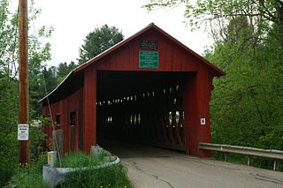
The Red Covered Bridge is a historic covered bridge, carrying Cole Hill Road across Sterling Brook in Morristown, Vermont. Built in 1896, it is the only surviving 19th-century covered bridge in the town, and one of the last to be built during the historic period of covered bridge construction in the state. It is of queen post truss design, and was listed on the National Register of Historic Places in 1974.


