Fort White, Florida

Last updated
Fort White, Florida
Town of Fort White
FortWhiteFLMon.png
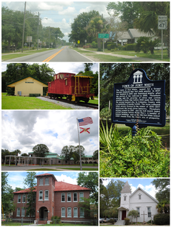
Top, left to right: Florida State Road 47 in Fort White, Fort White Train Depot, Fort White High School, Town of Fort White Historical Marker, Fort White Public School Historic District, Fort White United Methodist Church
Motto: 
Home of the Ichetucknee River [1]
Columbia County Florida Incorporated and Unincorporated areas Fort White Highlighted.svg
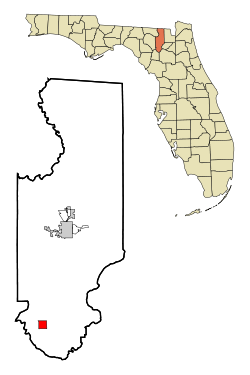
Location in Columbia County and the state of Florida
Coordinates: 29°55′23″N82°42′51″W / 29.92306°N 82.71417°W / 29.92306; -82.71417
Country Flag of the United States.svg  United States
State Flag of Florida.svg  Florida
County   Columbia
Incorporated 1884 [2]
Government
  Type Mayor-Council
   Mayor Ronnie Frazier Jr.
   Councilors Jason Florence,
Mary Fleming, Travis King,
and William Koon
   Town Clerk Connie Brecheen
   Town Attorney Lindsey B. Lander
Area
[3]
  Total2.41 sq mi (6.25 km2)
  Land2.41 sq mi (6.25 km2)
  Water0.00 sq mi (0.00 km2)
Elevation
69 ft (21 m)
Population
 (2020)
  Total618
  Density256.01/sq mi (98.86/km2)
Time zone UTC-5 (Eastern (EST))
  Summer (DST) UTC-4 (EDT)
ZIP code
32038
Area code 386
FIPS code 12-24500 [4]
GNIS feature ID0282713 [5]
Website fortwhitefl.com

Fort White is a town in Columbia County, Florida, United States, named after a military fort built in the 1830s. It is the closest town to Ichetucknee Springs State Park. Fort White High School and the Fort White Public School Historic District are located within the town's borders. The original school building was constructed in 1915. As of the 2020 census, the population of Fort White was 618.

Contents

History

Excerpt from A Map of the Seat of War in Florida showing the fort location of Ft. White in 1839. FTWhiteSW.png
Excerpt from A Map of the Seat of War in Florida showing the fort location of Ft. White in 1839.

Fort White was originally constructed as a military fort during the Second Seminole War in 1836 to protect the Cow Creek settlement. Supplies were brought in by steamboat on the Santa Fe River and distributed to other area forts. Due to sickness, flooding along the river and rumors of the railroad coming to the area, the settlement was moved 4 miles (6 km) east to its present location.

Named after the military fort, in 1884, the Town of Fort White was officially incorporated and grew steadily, following the arrival of the railroad in 1888. [2] Phosphate mining, turpentine and agriculture (cotton and oranges) were the foundation of the economy, and the population grew to nearly 2,000. The boom turned to bust as severe freezes in the winters of 1896 and 1897 destroyed the local citrus industry. By 1910, the largest phosphate deposits were depleted and mining ceased. The boll weevil ended cotton farming before World War I, and the population shrank to a few hundred people, primarily farmers, ranchers and foresters. The town's population in 1979 was 365.

Geography

U.S. Route 27 in Fort White. FTWhiteR27.jpg
U.S. Route 27 in Fort White.

The exact coordinates for the Town of Fort White is located in southern Columbia County at 29°55′23″N82°42′51″W / 29.92306°N 82.71417°W / 29.92306; -82.71417 (29.923001, –82.714299), [6] at the intersection of U.S. Route 27 and Florida State Road 47. SR 47 leads north 20 miles (32 km) to Lake City, the Columbia County seat, and south 23 miles (37 km) to Trenton. US 27 leads southeast 16 miles (26 km) to Alachua and Interstate 75, and west 13 miles (21 km) to Branford.

According to the United States Census Bureau, Fort White has a total area of 2.4 square miles (6.2 km2), all land. [7] Most of the land surrounding the town is family farms and/or forests.

The Ichetucknee River

The locals have always known of and enjoyed the crystal clear Ichetucknee River and springs, located 4 miles (6 km) northwest of the town. However, before 1970, the existence and location of this natural wonder were not widely known. The road to the spring was not paved, nor was it marked, because the spring was on private property. In 1970, the state of Florida purchased the Ichetucknee spring and river property from the Loncala Phosphate Corporation. Columbia County built a paved road, number 238, providing easier access to the springs. In 1972, the head spring of the river was declared a National Natural Landmark by the U.S. Department of the Interior. The main tributary from Ichetucknee Springs became one of the most popular tubing destinations in the world, attracting up to 5,000 visitors each day during the summer. Others came to the river to swim, picnic, snorkel, scuba dive, and explore the nearby forests. [8]

Climate

The climate in this area is characterized by hot, humid summers and generally mild winters. According to the Köppen climate classification, the Town of Fort White has a humid subtropical climate zone (Cfa).

Demographics

Historical population
CensusPop.Note
1890 376
1900 60059.6%
1910 329−45.2%
1920 3609.4%
1930 272−24.4%
1940 31716.5%
1950 3293.8%
1960 42529.2%
1970 365−14.1%
1980 3865.8%
1990 268−30.6%
2000 40952.6%
2010 56738.6%
2020 6189.0%
U.S. Decennial Census [9]

2010 and 2020 census

Fort White racial composition
(Hispanics excluded from racial categories)
(NH = Non-Hispanic)
RacePop 2010 [10] Pop 2020 [11] % 2010% 2020
White (NH)33440658.91%65.70%
Black or African American (NH)17114930.16%24.11%
Native American or Alaska Native (NH)420.71%0.32%
Asian (NH)350.53%0.81%
Pacific Islander or Native Hawaiian (NH)010.00%0.16%
Some other race (NH)120.18%0.32%
Two or more races/Multiracial (NH)12122.12%1.94%
Hispanic or Latino (any race)42417.41%6.63%
Total567618

As of the 2020 United States census, there were 618 people, 214 households, and 164 families residing in the town. [12]

As of the 2010 United States census, there were 567 people, 311 households, and 169 families residing in the town. [13]

2000 census

As of the census [4] of 2000, there were 409 people, 151 households, and 104 families residing in the town. The population density was 176.8 inhabitants per square mile (68.3/km2). There were 184 housing units at an average density of 79.5 per square mile (30.7/km2). The racial makeup of the town was 50.61% White, 46.70% African American, 0.24% Native American, 0.49% Asian, 0.24% Pacific Islander, and 1.71% from two or more races. Hispanic or Latino of any race were 3.42% of the population.

In 2000, there were 151 households, out of which 33.8% had children under the age of 18 living with them, 43.7% were married couples living together, 19.2% had a female householder with no husband present, and 31.1% were non-families. 28.5% of all households were made up of individuals, and 9.9% had someone living alone who was 65 years of age or older. The average household size was 2.71 and the average family size was 3.35.

In 2000, in the town, the population was spread out, with 28.6% under the age of 18, 8.1% from 18 to 24, 24.9% from 25 to 44, 22.5% from 45 to 64, and 15.9% who were 65 years of age or older. The median age was 37 years. For every 100 females, there were 76.3 males. For every 100 females age 18 and over, there were 82.5 males.

In 2000, the median income for a household in the town was $26,250, and the median income for a family was $28,000. Males had a median income of $26,477 versus $26,667 for females. The per capita income for the town was $10,578. About 24.1% of families and 26.8% of the population were below the poverty line, including 23.0% of those under age 18 and 42.0% of those age 65 or over.

Government services

The town elects a mayor and four town council members who meet once each month. Water is provided through the city, but all residents utilize a septic tank system for sewerage. Law enforcement is provided by the Columbia County Sheriff's Office who utilize a sub-station within the city limits. Fire protection is provided by the Columbia County Fire Department. Garbage collection is subcontracted to a private company. The Fort White Branch of the Columbia County Public Library system, which was previously located next to town hall, is across from Fort White High School. The county health clinic has a satellite office in Fort White which is open one day each week, but the nearest hospital facility is in Lake City. [14]

The Fort White Sports Complex was constructed in 2005 on 25 acres (10 ha) abutting the high school. Facilities include six baseball fields, two basketball courts and two tennis courts. A community center was built on the site in 2008. A senior citizen meal program operates at the center on weekdays. [14]

Schools

Fort White High School FortWhiteHighSchool17.jpg
Fort White High School

The public schools located within the Town of Fort White are served by the Columbia County School District.

The original Fort White High School was constructed during 1915, and an auditorium was added in 1936. Separate elementary school classrooms were completed in 1938. [15]

The last high school class to graduate was in 1969, about the same time desegregation and integration forced the closing of the black schools in the area. At that time, there weren't enough children to justify a high school in Fort White; students in grades 9–12 were bused 20 miles (32 km) to Columbia High School in Lake City for over 30 years. After Ichetucknee Springs State Park opened in 1971, the population in the south end of the county steadily grew to the point where the need for a local facility was substantiated.

A $25 million high school was completed in December 2000 for grades 6–12, having opened in August 2000, in temporary buildings because of construction delays. The school had been scheduled for completion in August 2000. Fort White High School graduated the first class in a generation in 2001. A new Fort White Middle School for grade 6 was completed prior to the 2008–2009 school year. The rest of the middle school (for grades 7 and 8) has recently been finished and is in use, though the middle and high school are still joined.

Related Research Articles

<span class="mw-page-title-main">Columbia County, Florida</span> County in Florida, United States

Columbia County is a county located in the north central portion of the U.S. state of Florida. As of the 2020 census, the population was 69,698, up from 67,531 at the 2010 census. Its county seat is Lake City.

<span class="mw-page-title-main">Suwannee County, Florida</span> County in Florida, United States

Suwannee County is a county located in the north central portion of the state of Florida. As of the 2020 census, the population was 43,474, up from 41,551 in 2010. Its county seat is Live Oak. Suwannee County was a dry county until August 2011, when the sale of alcoholic beverages became legal in the county.

<span class="mw-page-title-main">Davie, Florida</span> City in Florida, United States

Davie is a town in Broward County, Florida, United States, approximately 24 miles (39 km) north of Miami. The town's population was 110,320 at the 2020 census, Davie is a principal town of the Miami metropolitan area. Horseback riding is common, as much of its historic buildings include ranches and other Western establishments.

<span class="mw-page-title-main">Orange Park, Florida</span> Town in the state of Florida, United States

Orange Park is a town in Clay County, Florida, United States. It is a suburb of Jacksonville, in neighboring Duval County. The population was 9,089 at the 2020 census. The name "Orange Park" is additionally applied to a wider area of northern Clay County outside the town limits, covering such communities as Lakeside, Bellair-Meadowbrook Terrace and Oakleaf Plantation.

<span class="mw-page-title-main">Havana, Florida</span> Town in the state of Florida, United States

Havana is a town in Gadsden County, Florida, United States, and a suburb of Tallahassee. The population was 1,753 at the 2020 census. It is part of the Tallahassee Metropolitan Statistical Area. The town was named after Havana, Cuba, located about 530 miles (850 km) to the south.

<span class="mw-page-title-main">White Springs, Florida</span> Town in the state of Florida, United States

White Springs is a town in North Florida on the Suwannee River. The population was 740 at the 2020 census. Home of the annual Florida Folk Festival, it is a tourist destination noted for historic charm, antique shops, and river recreation.

<span class="mw-page-title-main">Zolfo Springs, Florida</span> Town in the state of Florida, United States

Zolfo Springs is a town in Hardee County, Florida, United States. It is part of the Florida Heartland region. The population was 1,737 at the 2020 census.

<span class="mw-page-title-main">Avon Park, Florida</span> City in Florida, United States

Avon Park is a city in Highlands County, Florida, United States. As of the 2020 census, the population was 9,658, up from the 2010 census when the population was 8,836, but down from the estimated population of 10,695 in 2018. It is the oldest city in Highlands County, and was named after Stratford-upon-Avon, England.

<span class="mw-page-title-main">Cottondale, Florida</span> City in Florida, United States

Cottondale is a city in Jackson County, Florida, United States. It is part of the Florida Panhandle and North Florida. The population was 848 at the 2020 census, down from 933 at the 2010 census.

<span class="mw-page-title-main">Malone, Florida</span> Town in the state of Florida, United States

Malone is a town in Jackson County, Florida, United States. The population was 1,959 at the 2020 census.

<span class="mw-page-title-main">Greenville, Florida</span> Town in the state of Florida, United States

Greenville is a town in Madison County, Florida, United States. The population was 746 at the 2020 census, down from 843 at the 2010 census.

<span class="mw-page-title-main">Belleview, Florida</span> City in Florida, United States

Belleview is a city in Marion County, Florida, United States. The population was 5,413 at the 2020 census, up from 4,492 in 2010. It is part of the Ocala Metropolitan Statistical Area. The city's name comes from the French words belle and vue, meaning "beautiful view". "City with Small Town Charm" is the city's motto.

<span class="mw-page-title-main">Silver Springs Shores, Florida</span> Census-designated place in Florida, United States

Silver Springs Shores is a census-designated place (CDP) in Marion County, Florida, United States. The population was 24,846 at the 2020 census. It is part of the Ocala Metropolitan Statistical Area.

<span class="mw-page-title-main">Ives Estates, Florida</span> Census-designated place in Florida

Ives Estates is a census-designated place (CDP) in Miami-Dade County, Florida. It is part of the Miami metropolitan area of South Florida. The population was 25,005 at the 2020 census, up from 19,525 in 2010.

<span class="mw-page-title-main">Palm Springs North, Florida</span> Census-designated place in Florida

Palm Springs North is an unincorporated community and census-designated place (CDP) in Miami-Dade County, Florida, United States. It is part of the Miami metropolitan area of South Florida. The population was 5,030 at the 2020 census.

<span class="mw-page-title-main">Oakland, Florida</span> Town in the state of Florida, United States

Oakland is a town in Orange County, Florida, United States. The population was 3,516 at the 2020 Census, representing a growth of 38.5% over the population of 2,538 recorded during the 2010 census. It is part of the Orlando–Kissimmee Metropolitan Statistical Area.

<span class="mw-page-title-main">Branford, Florida</span> Town in Florida, United States

Branford is a town in Suwannee County, Florida, United States. The Town of Branford was officially incorporated as a municipality in 1961, although it has been settled since 1886. The population was 711 at the 2020 census.

<span class="mw-page-title-main">Freeport, Florida</span> City in Florida, United States of America

Freeport is a city in Walton County, Florida, United States. It is part of the Crestview–Fort Walton Beach–Destin metropolitan area. As of the 2020, the population recorded by the U.S. Census Bureau was 5,861.

North Vacherie is a census-designated place (CDP) in St. James Parish, Louisiana, United States. The population was 2,411 at the 2000 census. Vacherie was noted in the 2000 census as being the town with the least mobility of all in the United States.

<span class="mw-page-title-main">Grantsville, West Virginia</span> Town in West Virginia, United States

Grantsville is a town in Calhoun County, West Virginia, United States. The population was 482 at the 2020 census. It is the county seat of Calhoun County. The town was established along the Little Kanawha River in 1865 and named for Ulysses S. Grant. Grantsville is home to Wayne Underwood Park, which includes a .25-mile-long (0.40 km) walking trail, and to the annual West Virginia Wood Festival.

References

  1. "Home page" Town of Fort White website
  2. 1 2 "FLORIDA CITIES BY INCORPORATION YEAR WITH INCORPORATION & DISSOLUTION INFO" (PDF). www.flcities.com.
  3. "2020 U.S. Gazetteer Files". United States Census Bureau. Retrieved October 31, 2021.
  4. 1 2 "U.S. Census website". United States Census Bureau . Retrieved 2008-01-31.
  5. "US Board on Geographic Names". United States Geological Survey. 2007-10-25. Retrieved 2008-01-31.
  6. "US Gazetteer files: 2010, 2000, and 1990". United States Census Bureau. 2011-02-12. Retrieved 2011-04-23.
  7. "Geographic Identifiers: 2010 Demographic Profile Data (G001): Fort White town, Florida". U.S. Census Bureau, American Factfinder. Archived from the original on February 12, 2020. Retrieved July 17, 2014.
  8. "Ichetucknee" Archived 2007-08-24 at the Wayback Machine Florida Springs website
  9. "Census of Population and Housing". Census.gov. Retrieved June 4, 2015.
  10. "P2 HISPANIC OR LATINO, AND NOT HISPANIC OR LATINO BY RACE - 2010: DEC Redistricting Data (PL 94-171) - Fort White town, Florida". United States Census Bureau .
  11. "P2 HISPANIC OR LATINO, AND NOT HISPANIC OR LATINO BY RACE - 2020: DEC Redistricting Data (PL 94-171) - Fort White town, Florida". United States Census Bureau .
  12. "S1101 HOUSEHOLDS AND FAMILIES - 2020: Fort White town, Florida". United States Census Bureau .
  13. "S1101 HOUSEHOLDS AND FAMILIES - 2010: Fort White town, Florida". United States Census Bureau .
  14. 1 2 "Fort White General Information" Archived 2010-04-18 at the Wayback Machine Town of Fort White website
  15. "Columbia County" Archived 2010-02-27 at the Wayback Machine Florida Division of Historical Resources, Florida's History Through Its Places