
Sequoia National Park is an American national park in the southern Sierra Nevada east of Visalia, California. The park was established on September 25, 1890, and today protects 404,064 acres of forested mountainous terrain. Encompassing a vertical relief of nearly 13,000 feet (4,000 m), the park contains the highest point in the contiguous United States, Mount Whitney, at 14,505 feet (4,421 m) above sea level. The park is south of, and contiguous with, Kings Canyon National Park; both parks are administered by the National Park Service together as the Sequoia and Kings Canyon National Parks. UNESCO designated the areas as Sequoia-Kings Canyon Biosphere Reserve in 1976.

The Merritt Parkway is a limited-access parkway in Fairfield County, Connecticut, with a small section at the northern end in New Haven County. Designed for Connecticut's Gold Coast, the parkway is known for its scenic layout, its uniquely styled signage, and the architecturally elaborate overpasses along the route. As one of the first, oldest parkways in the United States, it is designated as a National Scenic Byway and is also listed in the National Register of Historic Places. Signed as part of Route 15, it runs from the New York state line in Greenwich, where it serves as the continuation of the Hutchinson River Parkway, to Exit 54 in Milford, where the Wilbur Cross Parkway begins. Facing bitter opposition, the project took six years to build in three different sections, with the Connecticut Department of Transportation constantly requiring additional funding due to the area's high property value. The parkway was named for U.S. Congressman Schuyler Merritt. In 2010, the National Trust for Historic Preservation called the Merritt Parkway one of "America's 11 Most Endangered Historic Places".

Going-to-the-Sun Road is a scenic mountain road in the Rocky Mountains of the western United States, in Glacier National Park in Montana. The Sun Road, as it is sometimes abbreviated in National Park Service documents, is the only road that traverses the park, crossing the Continental Divide through Logan Pass at an elevation of 6,646 feet (2,026 m), which is the highest point on the road. Construction began in 1921 and was completed in 1932 with formal dedication in the following summer on July 15, 1933. Prior to the construction of the road, visitors would need to spend several days traveling through the central part of the park, an area which can now be traversed within a few hours, excluding any stops for sightseeing or construction.

Colonial Parkway is a 23-mile (37 km) scenic parkway linking the three points of Virginia's Historic Triangle, Jamestown, Williamsburg, and Yorktown. It is part of the National Park Service's Colonial National Historical Park. Virginia's official state classification for the parkway is State Route 90003. With portions built between 1930 and 1957, it links the three communities via a roadway shielded from views of commercial development. The roadway is toll-free, is free of semi trucks, and has speed limits of around 35 to 45 mph. As a National Scenic Byway and All-American Road, it is also popular with tourists due to the James River and York River ends of the parkway.
The Generals Highway is a highway that connects State Route 180 and State Route 198 through Sequoia National Park, Sequoia National Forest, Giant Sequoia National Monument, and Kings Canyon National Park in the Sierra Nevada of California. As the road goes through national parks and monuments, the highway is primarily maintained by the federal government instead of a California State Highway controlled by Caltrans.

The Kaweah River is a river draining the southern Sierra Nevada in Tulare County, California in the United States. Fed primarily by high elevation snowmelt along the Great Western Divide, the Kaweah begins as four forks in Sequoia National Park, where the watershed is noted for its alpine scenery and its dense concentrations of giant sequoias, the largest trees on Earth. It then flows in a southwest direction to Lake Kaweah – the only major reservoir on the river – and into the San Joaquin Valley, where it diverges into multiple channels across an alluvial plain around Visalia. With its Middle Fork headwaters starting at almost 13,000 feet (4,000 m) above sea level, the river has a vertical drop of nearly two and a half miles (4.0 km) on its short run to the San Joaquin Valley, making it one of the steepest river drainages in the United States. Although the main stem of the Kaweah is only 33.6 miles (54.1 km) long, its total length including headwaters and lower branches is nearly 100 miles (160 km).

The Grand Loop Road is a historic district which encompasses the primary road system in Yellowstone National Park. Much of the 140-mile (230 km) system was originally planned by Captain Hiram M. Chittenden of the US Army Corps of Engineers in the early days of the park, when it was under military administration. The Grand Loop Road provides access to the major features of the park, including the Upper, Midway and Lower geyser basins, Mammoth Hot Springs, Tower Fall, the Grand Canyon of the Yellowstone and Yellowstone Lake.

The Corduroy Creek Bridge was a steel arch highway bridge on US 60, located near Show Low in Navajo County, Arizona.
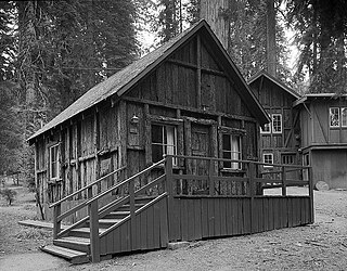
The Giant Forest Lodge Historic District in Sequoia National Park includes the remnants of what was once an extensive National Park Service Rustic style tourist development for park visitors. Also known as Camp Sierra, the district was listed on the National Register of Historic Places in May 1978. Originally situated in the Giant Forest grove of giant sequoias, the district is notable for its nearly total demolition by the National Park Service to eliminate the impact of development on the Big Trees.

The Giant Forest Village–Camp Kaweah Historic District is located in Sequoia National Park. It is notable as one of two registered historic districts in the park that were largely demolished as part of National Park Service efforts to mitigate the impact of park visitor facilities on the park's giant sequoia groves. They were in a vernacular National Park Service Rustic and American Craftsman Bungalow style.

The Floor of the Valley Road, also known as the Zion Canyon Scenic Drive, follows the canyon of the North Fork of the Virgin River, also known as Zion Canyon, through Zion National Park, Utah, USA. A precursor to the present nine-mile road was first built in 1916, but was later redesigned by the National Park Service Branch of Plans and Designs to highlight the natural features of the valley while presenting a natural-appearing built environment. The road begins at the south boundary of the park and ends at the Temple of Sinawava.

The Zion – Mount Carmel Highway is a 25-mile (40 km) long road in Washington and Kane counties in southern Utah, United States, that is listed on the National Register of Historic Places and is a National Historic Civil Engineering Landmark.

The Hayden Arch Bridge is a concrete arch bridge on old US 14/US 16 near Cody, Wyoming. It is the only example of its kind in Wyoming. Built in 1924–25, the single-span bridge spans 115 feet (35 m) with two smaller approach arches between rock canyon walls. The bridge carries the Cody-Yellowstone Highway across the Shoshone River with a shallow open-spandrel central arch and nominally arched approach spans. The bridge is named after C. E. Hayden, an engineer with the Wyoming State Highway Department, who designed the bridge and supervised its construction. It was built by H. S. Crocker of Denver, Colorado.

The historical buildings and structures of Zion National Park represent a variety of buildings, interpretive structures, signs and infrastructure associated with the National Park Service's operations in Zion National Park, Utah. Structures vary in size and scale from the Zion Lodge to road culverts and curbs, nearly all of which were designed using native materials and regional construction techniques in an adapted version of the National Park Service Rustic style. A number of the larger structures were designed by Gilbert Stanley Underwood, while many of the smaller structures were designed or coordinated with the National Park Service Branch of Plans and Designs. The bulk of the historic structures date to the 1920s and 1930s. Most of the structures of the 1930s were built using Civilian Conservation Corps labor.

The St. Andrews Creek Bridge was built in 1930-31 as part of the West Side Road in Mount Rainier National Park. The bridge spans 26 feet (7.9 m) and is almost 34 feet (10 m) wide, carrying a two-lane road on a stone-faced concrete bridge. The West Side Road was planned to link the Nisqually and Carbon River entrances to the park, but only 13 miles (21 km) were completed in six years.

The Yosemite Valley Bridges are eight bridges in the Yosemite Valley of Yosemite National Park, most of them spanning the Merced River. Five of them were built in 1928, with the remainder built between 1921 and 1933. The bridges feature a concrete structure faced with local stone, in an elliptical or three-centered arch configuration. They are notable for their uniform character and for their conformance to tenets of the National Park Service rustic style. Design work for the seven newer bridges was by George D. Whittle of the San Francisco District Office of the U.S. Bureau of Public Roads for the National Park Service. Concrete bridges were chosen at the urging of Thomas Chalmers Vint of the Park Service, in lieu of alternative designs for steel truss bridges, or suspension bridges suggested by the park superintendent.

The North Fork Bridge carries Arkansas Highway 5 over the North Fork River, or the North Fork of the White River, in Norfork, Arkansas, United States. It is a modern steel girder bridge, replacing a 1937 Warren deck truss bridge, which was the first road crossing of the North Fork River in Norfork. The 1937 bridge, demolished in 2014, was listed on the U.S. National Register of Historic Places in 1990, but was delisted in 2015.

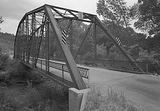
The AJX Bridge is a historic Pratt truss bridge in southwestern Johnson County, Wyoming. The bridge was built in 1931 across the South Fork of the Powder River near Kaycee, Wyoming. AJX Bridge was built to provide a river crossing for U.S. Route 87. It was placed on the National Register of Historic Places in 1985 as part of a Multiple Property Submission devoted to historic bridges in Wyoming.
John Bernard Wosky was an American architect and landscape architect and park superintendent. He worked for the National Park Service from the 1920s through the 1950s and designed a number of works that have been listed on the National Register of Historic Places. He was assigned to Yosemite National Park from 1928 to 1952, initially as the parks's resident architect, and later as its assistant superintendent. He later served as the superintendent at Crater Lake National Park and Hawaii Volcanoes National Park.
The Rockville Bridge spans the east fork of the Virgin River in Rockville, Utah, United States. The bridge was built for the National Park Service in 1924 to provide a link between Zion National Park and the North Rim area of Grand Canyon National Park. The new bridge allowed motorists to take a circular tour of the national parks in southern Utah and northern Arizona. The Rockville route was superseded in 1928 by the construction of the Zion-Mount Carmel Highway.


