Grant Road Historic District

Last updated
Grant Road Historic District
Grant Road Historic District 1.jpg
Facing west on the 4500 block of Grant Road NW. The narrow street maintains a rural character which is unusual in Washington, D.C. (2020)
Grant Road Historic District map.png
Location4400 and 4500 blocks of Grant Road NW
Washington, D.C.
Coordinates 38°56′55.6″N77°04′32.7″W / 38.948778°N 77.075750°W / 38.948778; -77.075750
NRHP reference No. 04000116 [1]
Significant dates
Added to NRHPMarch 3, 2004
Designated DCIHSApril 21, 2002

The Grant Road Historic District is located in the Tenleytown neighborhood of Washington, D.C. The two-block historic district is what remains of a former settlement in rural Washington County in the District of Columbia. It includes 13 contributing buildings and the road itself, a narrow remnant of a country road that was used by soldiers in the Civil War. Following the war, the road was named after Civil War general and President Ulysses S. Grant. Grant Road developed into a residential street lined with mostly small, two-story homes for working-class people.

Contents

As the surrounding area developed, Grant Road retained its rural character. Segments of the road were separated for large scale development of middle-class homes. Many of the homes that once lined Grant Road were demolished in the process. After a large, prominent house on the corner of Grant Road and Albemarle Street was demolished in 1999, residents sought historic landmark status for their properties. The historic district was added to the District of Columbia Inventory of Historic Sites in 2002 and listed on the National Register of Historic Places in 2004. The buildings date from the 1860s to 1900s. Residential styles employed include the I-house, Italianate boxes, and side and front gabled folk house forms. A former post office and general store are also located on Wisconsin Avenue.

Geography

The Grant Road Historic District is located on the 4400 and 4500 blocks of Grant Road NW in the Tenleytown neighborhood of Washington, D.C. The 4400 block begins north of Tenley Circle at the intersection with Wisconsin Avenue, then crosses Fort Drive. Nebraska Avenue divides the two blocks. The 4500 block begins at the junction of 39th Street, Albemarle Street, and Grant Street, then proceeds northeast to the intersection with Brandywine Street. The historic district ends at this intersection, but this portion of Grant Road extends for another half block. Nebraska Avenue separates Grant Street from a one block portion further northeast between Cumberland and Davenport Streets. [2] There are two additional stretches of Grant Road further east: two blocks between 30th and 32nd Streets, and an unnumbered portion between Broad Branch Road and Ridge Road that passes through Rock Creek Park. [3]

The historic district includes the road itself and 13 contributing buildings, one of which is a commercial building on Wisconsin Avenue. The remaining buildings are single-family homes on Grant Road: homes on the north side of the 4400 block and south side of the 4500 block. There are several non-contributing houses on the 4500 block that were built in the mid-20th century. The 4500 block of Grant Road is narrow at only 33 feet (10 m) wide, which is around half the standard width of streets in the city, and does not have a sidewalk or street furniture. The buildings on the 4400 block include the commercial building fronting Wisconsin Avenue and three homes on a small ridge. [2]

History

18th and 19th centuries

Around 1795, blacksmith John Tennally opened a small tavern at the intersection of present-day Wisconsin Avenue and River Road, which were former Native American footpaths. Around a dozen families soon moved to the area, forming a village called Tennallytown, the second oldest settlement in present-day Washington, D.C. [2] [4] [5] The village became a stagecoach stop for people traveling between Georgetown and Maryland. In the 1791 plan for the new federal City of Washington, the village was included in the city's boundary. Due to its distance from the city center, Tenallytown would remain a small rural village in Washington County for many years. The village's name gradually changed to the present spelling, Tenleytown. [2] [6]

In 1805 present-day Wisconsin Avenue became a toll road and was later macadamized in the late 1810s and early 1820s. The village continued to grow in the 1800s, with a church, school, houses, and other businesses built near the tavern. By the 1850s the stagecoach service had ended due to the Baltimore and Ohio Railroad and the village was connected to rural communities to its east by a country lane that was called New Cut Road or Road from Turnpike to Broad Branch. [2] [7]

During the Civil War farmland in the surrounding area was seized by the federal government after the Union Army was defeated at the First Battle of Bull Run. The government built Fort Reno, one of 68 fortifications built to defend the city, on the city's highest natural point of 409 feet (125 m). [2] [4] [6] New Cut Road was just south of Fort Reno and was used by soldiers to traverse between other forts. During the war Thomas Paxton reportedly constructed three houses on the present-day 4400 block of Grant Road. It is believed to be the same houses that stand there today. One of these homes, 4434 Grant Road NW, also known as the Tenant House, was possibly built as a tenant house for The Rest, an early 18th century house at 39th Street and Windom Place which is the neighborhood's oldest residence. [2] [6]

An 1870 map of Grant Road and Tennallytown. Grant Road 1870.jpg
An 1870 map of Grant Road and Tennallytown.

Two schools were also built during the war. A school for white children stood on a hill overlooking the road and a school for black children was farther east, near the road's intersection with present-day Broad Branch Road. After the war New Cut Road was renamed in honor of General Ulysses S. Grant. Due to development that resulted from Fort Reno, the area's population increased and Grant Road became a residential street and important part of the village's growth. [2]

The last quarter of the 19th century saw gradual development on Grant Road and the surrounding farmland area. The land where Fort Reno stood became a predominantly black neighborhood called Reno City. German, Irish, and Italian immigrants moved to Tenleytown, building their houses and opening a variety of shops. The area became a working class village, with two-story frame houses lining streets on the east side of Wisconsin Avenue. Most of the buildings in the historic district date from this period. The commercial building at 4425 Wisconsin Avenue NW, the oldest surviving commercial building in the neighborhood, was constructed in 1887 by John J. O'Day. It originally served as the O'Day General Store and Tenleytown Post Office. The house at 3837 Albemarle Street NW was reportedly built near the Old Naval Observatory in the mid 19th century, but relocated in the 1890s. Six surviving homes along the 4500 block of Grant Road were built between 1890 and 1894. [2]

During the 1890s a streetcar line was installed along Wisconsin Avenue, linking the village with Georgetown and resulting in further development. The population of Tenleytown increased from 731 to 1,127 between 1892 and 1897 and large amounts of homes and shops were built along Wisconsin Avenue and the surrounding streets. In 1894 there were over 30 buildings on the 4400 and 4500 blocks of Grant Road. The road played such an important role in local development that a 1899 article in the Evening Star said that if Tenleytown was a hand, Grant Road was its thumb "with twisting and turning knuckles, grabbed onto by more than its shares of houses." [2]

20th and 21st centuries

By 1900 there were six churches, several schools, and a firehouse in Tenleytown, along with a variety of specialty businesses including a restaurant, grocery shops, pharmacy, butcher shop, and dry goods store. [2] President Theodore Roosevelt would ride his horse through the area as he made his way from the White House to his nearby hunting lodge. He reportedly stopped at the house at 4426 Grant Road NW on at least two occasions to take the children for a horseback ride. The two 20th century houses in the historic district, 4547 and 4555 Grant Road NW, were built during this period in 1908. [2] [6]

During the 1910s real estate developers purchased large amounts of land in the area to build middle-class homes for white residents. These projects didn't succeed until after World War I when developers Harry Kite and Samuel Kite Jr. led development east of Wisconsin Avenue, inspired by the success of nearby upper middle class subdivisions such as Chevy Chase, Cleveland Park, and Friendship Heights. These developments changed the demographics of Tenleytown from a working class village to middle-class neighborhood, and Reno City was demolished beginning in 1928. [2] [6] The developments also led to new roads being cut through the area. Wisconsin Avenue was widened in 1919 to accommodate streetcars and automobiles, and Albemarle Street was extended from Reno Road to Wisconsin Avenue. When Albemarle Street was extended in 1931, three houses on Grant Road were demolished and two were moved, including 3837 Albemarle Street NW. The houses on the 4400 block of Grant Road also lost their rear yards when Albemarle Street was extended. [2]

In addition to the Albemarle Street extension, there was significant changes to Grant Road during the 1930s. Tenley Circle was paved in 1936, becoming a busy intersection for busses and streetcars, 39th Street was extended to Albemarle Street, and the diagonal Nebraska Avenue was created to link Tenleytown with Connecticut Avenue. Several houses were demolished in the process and in 1937 C. Harold Gray wrote: "Tenleytown was the nucleus of an extensive country road net which has since largely disappeared...In extending Washington's straight streets through the community, many of the buildings were removed and its appearance changed almost beyond recognition." [2]

There were also large developments that changed the character of the neighborhood. Woodrow Senior High and Deal Junior High were built, a reservoir and water tower were built on the Fort Reno site, and the National Capital Planning Commission planned a scenic drive that would connect Civil War era forts. To build this scenic road, named Fort Reno Drive, several houses on Grant Road were demolished. The plan was approved by the neighborhood's new middle class residents, who thought the older buildings were unattractive and hurt the value of their own properties, but the project was later cancelled. [2]

Chappell House, demolished in 1999 Chappell House.jpg
Chappell House, demolished in 1999

After Nebraska Avenue was completed, homes were built along the road in the 1940s. The rear of these homes face the north side of the 4500 block of Grant Road. In the 1950s and 1960s some of the lots on the south side of the 4500 block of Grant Road were divided to accommodate construction of new homes. These mid to late 20th century homes on each side of the block are considered noncontributing to the historic district, but due to the deep lots of the Nebraska Avenue properties, Grant Road kept the appearance of a rural country road. [2]

After Metro's Tenleytown station opened in the 1980s, there was significant development in the neighborhood. In the 1990s there were calls for higher density housing to be built close to the Metro station. This was welcomed by locals, but they wanted this new housing to be built along major roads like Wisconsin Avenue. In 1999 the large house on the northwest corner of Albemarle Street and Grant Road was demolished and replaced with condominiums. The house had been built in 1890 for Dr. John W. Chappell and included a large garden. It was considered one of the nicest buildings on Grant Road and its demolition was protested by area residents. [2] [8]

The people who lived in the remaining houses on Grant Road took notice and sought to protect their properties from demolition. Following a historic landmark designation process, the 4400 and 4500 blocks of Grant Road and its 13 remaining historic buildings were added to the District of Columbia Inventory of Historic Sites on April 21, 2002, and listed on the National Register of Historic Places on March 3, 2004. [2] [9] The Grant Road Historic District was the first historic district in the city to include just a single street. [10] In 2017 a mural depicting some of Tenleytown's history and landmarks was painted on the side of 4425 Wisconsin Avenue NW. [11]

Architecture

Facing east down the 4500 block of Grant Road NW. The house in the foreground is 4537 Grant Road NW. Grant Road Historic District 4.jpg
Facing east down the 4500 block of Grant Road NW. The house in the foreground is 4537 Grant Road NW.

The two-story stucco and stone commercial building at 4425 Wisconsin Avenue NW is one of several buildings in the historic district designed in the Italianate style. The building is two-stories and three bays wide with a sloped roof. It originally included a projecting storefront but that was later replaced with the current show window. The building's main entrance is on Wisconsin Avenue, but the side door facing Grant Road originally served as a second entrance. [2]

The Italianate two-story house at 4426 Grant Road NW, also listed as 3926 Albemarle Street NW, is historically known as the Burrows House. This is one of three houses reportedly built by Thomas Paxton in the 1860s and all are set slightly higher than street level. The building is three bays wide and features a gabled roof. The stone chimney, stone retaining wall, and stone columns supporting the one-story porch were reportedly quarried from local stones by W. Tyson Burrow in the 1880s. There is a one-story garage facing Albemarle Street. The house at 4430 Grant Road NW was designed in the vernacular Italianate style and is historically known as the Parks-Conner House. It is a two-story frame building with two bays and a bracketed cornice. The one-story wrap-around porch includes decorative elements. The vernacular Tenant House at 4434 Grant Road NW is believed to be the oldest of the three houses. Stucco covers the two-story, three-bay-wide frame building. There is a central chimney, gabled roof, and one-story porch. The original decorative porch included gingerbread detailing. [2]

The first house on the next block is 3837 Albemarle Street NW, historically known as the Christian-Curran House. It is sited at the intersection of 39th Street, Albemarle Street, and Grant Road. The L-shaped building was designed in the vernacular Italianate style and is two bays wide with a hipped roof and one-story wrap-around porch. The Italianate house at 3831 Albemarle Street NW is historically known as the Poore House. The frame building is three bays wide and features a one-story porch. [2]

The Hesterberg House at 4537 Grant Road NW was designed in the vernacular Greek Revival style. The rectangular building is two-and-a-half stories, three bays wide, four bays deep, and is connected to a one-story addition. The house at 4543 Grant Road NW is historically known as the Admiral's House. The house was originally two-story, L-shaped, and two bays wide, but was renovated into a 2+12-story, four-bay-wide Colonial Revival building with a small porch. The Folk Victorian house at 4547 Grant Road NW is historically known as the Cottage. The house is a two-story frame building, two bays wide, and its original one-story porch includes decorative elements. The Voight House at 4555 Grant Road NW was designed in the Italianate style. It is two-stories, two bays wide, with a one-story side porch. [2] [12]

The house at 4561 Grant Road NW, also known as the Payne House, is another two-story, two-bay wide Italianate house. It includes the original porch with decorative elements. The vernacular I-house at 4565 Grant Road NW is two-stories and three bays wide with a small porch. The last house in the historic district, 3812 Brandywine Street NW, is also two-stories and three bays wide. It was designed in the Italianate style and includes a small porch. [2] [12]

Table of contributing buildings

Rating [2] ImageAddress [2] Year [2] Style [2] Comments
Contributing 4425 Wisconsin Avenue NW.jpg 4425 Wisconsin Avenue NW
38°56′50.1″N77°04′44.3″W / 38.947250°N 77.078972°W / 38.947250; -77.078972 (4425 Wisconsin Avenue NW)
1887 Italianate Tenleytown's oldest surviving commercial building. [2]
Contributing 4426 Grant Road NW.jpg 4426 Grant Road NW
38°56′51.5″N77°04′41.5″W / 38.947639°N 77.078194°W / 38.947639; -77.078194 (4426 Grant Road NW)
1860sItalianateAlso listed as 3926 Albemarle Street NW and known as the Burrows House. Features stonework that was locally quarried by W. Tyson Burrow. [2] [12]
Contributing 4430 Grant Road NW.jpg 4430 Grant Road NW
38°56′51.6″N77°04′44.1″W / 38.947667°N 77.078917°W / 38.947667; -77.078917 (4430 Grant Road NW)
1860sItalianateAlso known as the Parks-Conner House. [12]
Contributing 4434 Grant Road NW.jpg 4434 Grant Road NW
38°56′51.8″N77°04′40.6″W / 38.947722°N 77.077944°W / 38.947722; -77.077944 (4434 Grant Road NW)
1860s Vernacular Also known as the Tenant House. Believed to be the oldest of the three houses on this block. [2] [12]
Contributing 3837 Albemarle Street.jpg 3837 Albemarle Street NW
38°56′53″N77°04′36.2″W / 38.94806°N 77.076722°W / 38.94806; -77.076722 (3837 Albemarle Street)
Mid-19th centuryItalianateAlso known as the Christian-Curran House. [12]
Contributing 3831 Albemarle Street NW.jpg 3831 Albemarle Street NW
38°56′53.5″N77°04′34.1″W / 38.948194°N 77.076139°W / 38.948194; -77.076139 (3831 Albemarle Street NW)
1894ItalianateAlso listed as 4521 Grant Road NW and known as the Poore House. [2] [12]
Contributing 4537 Grant Road NW.jpg 4537 Grant Road NW
38°56′54.9″N77°04′32.7″W / 38.948583°N 77.075750°W / 38.948583; -77.075750 (4537 Grant Road NW)
1890 Greek Revival Also known as the Hesterberg House. [12]
Contributing 4543 Grant Road NW.jpg 4543 Grant Road NW
38°56′55.5″N77°04′31.6″W / 38.948750°N 77.075444°W / 38.948750; -77.075444 (4543 Grant Road NW)
1890 Colonial Revival Also known as the Admiral's House. [12]
Contributing 4547 Grant Road NW.jpg 4547 Grant Road NW
38°56′55.9″N77°04′31.4″W / 38.948861°N 77.075389°W / 38.948861; -77.075389 (4547 Grant Road NW)
1908 Folk Victorian Also known as the Cottage. [12]
Contributing 4555 Grant Road NW.jpg 4555 Grant Road NW
38°56′56.6″N77°04′31.2″W / 38.949056°N 77.075333°W / 38.949056; -77.075333 (4555 Grant Road NW)
1908ItalianateAlso known as the Voight House. [12]
Contributing 4561 Grant Road NW.jpg 4561 Grant Road NW
38°56′57″N77°04′31.2″W / 38.94917°N 77.075333°W / 38.94917; -77.075333 (4561 Grant Road NW)
1890ItalianateAlso known as the Payne House. [12]
Contributing 4565 Grant Road NW.jpg 4565 Grant Road NW
38°56′57.6″N77°04′30.9″W / 38.949333°N 77.075250°W / 38.949333; -77.075250 (4565 Grant Road NW)
1892 I-house
Contributing 3812 Brandywine Street NW.jpg 3812 Brandywine Street NW
38°56′58.2″N77°04′32″W / 38.949500°N 77.07556°W / 38.949500; -77.07556 (3812 Brandywine Street NW)
1890Italianate

See also

Related Research Articles

<span class="mw-page-title-main">Tenleytown–AU station</span> Washington Metro station

Tenleytown–AU station is a subway station on the Red Line of the Washington Metro in Washington, D.C. Located in the Upper Northwest neighborhood, it is the last station on the Red Line heading outbound wholly within the District of Columbia; the next stop, Friendship Heights, lies within both the District and the state of Maryland. The station serves American University (AU).

<span class="mw-page-title-main">Tenleytown</span> Place in the United States

Tenleytown is a historic neighborhood in Northwest, Washington, D.C.

<span class="mw-page-title-main">Friendship Heights</span> Neighborhood in Ward 3, United States

Friendship Heights is an urban commercial and residential neighborhood in northwest Washington, D.C., and southern Montgomery County, Maryland. Though its borders are not clearly defined, Friendship Heights consists roughly of the neighborhoods and commercial areas around Wisconsin Avenue north of Fessenden Street NW and Tenleytown to Somerset Terrace and Willard Avenue in Maryland, and from River Road in the west to Reno Road and 41st Street in the east. Within Maryland west of Wisconsin Avenue is the Village of Friendship Heights, technically a special taxation district.

<span class="mw-page-title-main">Wakefield (Washington, D.C.)</span> Place in the United States

Wakefield is a neighborhood in the Northwest quadrant of Washington, D.C., bounded by Albemarle Street NW to the south, Nebraska Avenue NW to the west, and Connecticut Avenue to the east. It is served by the Van Ness-UDC and Tenleytown-AU station on the Washington Metro's Red Line.

<span class="mw-page-title-main">Tenley Campus</span> United States historic place

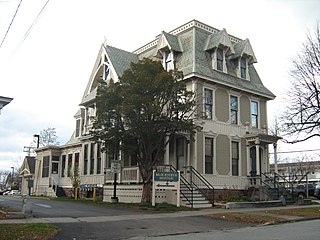
The Immaculata Seminary Historic District, commonly known as Tenley Campus, is an 8.2-acre (3.3 ha) parcel of land, located off of Tenley Circle in the Northwest Washington, D.C. neighborhood of Tenleytown. The site of Dunblane, an early to mid-nineteenth-century Federal/Greek Revival-style manor house, it was once part of a large country estate on the outskirts of the capital city, owned by a succession of prominent Georgetown residents. From 1904 to 1906, the land was acquired by the Catholic Sisters of Providence of Saint Mary-of-the-Woods, who, for decades, operated all-girls primary, secondary, and postsecondary schools there under the Immaculata name, before being forced to shutter due to financial issues. Since 1986, it has been a satellite campus of American University, which purchased the site in part because of its proximity to Tenleytown station on the Red Line of the Washington Metro. It currently houses the school's Washington College of Law.

<span class="mw-page-title-main">Merchants Avenue Historic District</span> Historic district in Wisconsin, United States

The Merchants Avenue Historic District in a residential neighborhood southeast of the downtown in Fort Atkinson, Wisconsin, composed of 33 mostly large homes on large lots within six city blocks around Merchants Avenue. It was placed on the United States National Register of Historic Places in 1986.

<span class="mw-page-title-main">Strivers' Section Historic District</span> Historic district in Washington, D.C., United States

The Strivers' Section Historic District is a historic district located in the Dupont Circle neighborhood of Washington, D.C. Strivers' Section was historically an enclave of upper-middle-class African Americans, often community leaders, in the late 19th and early 20th centuries. It takes its name from a turn-of-the-20th-century writer who described the district as "the Striver's section, a community of Negro aristocracy." The name echoes that of Strivers' Row in Harlem, a New York City historic neighborhood of black professionals. The district is roughly bounded by Swann Street and the Dupont Circle Historic District on the south, Florida Avenue and the Washington Heights Historic District on the north and west, and the Sixteenth Street Historic District on the east.

<span class="mw-page-title-main">Arbor Hill Historic District–Ten Broeck Triangle</span> Historic area of Albany, New York

The Arbor Hill Historic District–Ten Broeck Triangle, originally the Ten Broeck Historic District, is a seven-block area located within the Arbor Hill neighborhood north of what is today downtown Albany, New York, United States. In 1979 its easternmost third, the Ten Broeck Triangle, the second oldest residential neighborhood in the city, was recognized as a historic district and listed on the National Register of Historic Places. Four years later, the district was increased to its current size and renamed to reflect its expansion to include some of the rest of Arbor Hill.

<span class="mw-page-title-main">Knox Street Historic District</span> Historic district in New York, United States

The Knox Street Historic District is primarily located along one block of that street in the Park South neighborhood of Albany, New York, United States. Its contributing properties are several groups of attached rowhouses. The area was recognized as a historic district and listed on the National Register of Historic Places in 2008.

<span class="mw-page-title-main">South End–Groesbeckville Historic District</span> Historic district in New York, United States

The South End–Groesbeckville Historic District is located in part of the neighborhood of that name in Albany, New York, United States. It is a 26-block, 57-acre (23 ha) area south of the Mansion and Pastures neighborhoods with a mix of residential and commercial properties. In 1984 it was recognized as a historic district and listed on the National Register of Historic Places.

<span class="mw-page-title-main">Bridge Avenue Historic District</span> Historic district in Iowa, United States

The Bridge Avenue Historic District is located in a residential neighborhood on the east side of Davenport, Iowa, United States. It has been listed on the National Register of Historic Places since 1983. The historic district stretches from River Drive along the Mississippi River up a bluff to East Ninth Street, which is near the top of the hill.

<span class="mw-page-title-main">Sears, Roebuck and Company Department Store (Washington, D.C.)</span> United States historic place

Sears, Roebuck and Company Department Store, also known as The Cityline Building, is an historic retail building, located at 4500 Wisconsin Avenue, Northwest, Washington, D.C., in the Tenleytown neighborhood.

<span class="mw-page-title-main">Martin L. Kelsey House</span> Historic house in Vermont, United States

The Martin L. Kelsey House is a historic house at 43 Elmwood Avenue in Burlington, Vermont. Built in 1879 for a local merchant, it is a distinctive and architecturally varied house, with elements of the Second Empire, Queen Anne, and Stick styles on display. It was listed on the National Register of Historic Places in 1983, and now forms part of a senior housing complex.

<span class="mw-page-title-main">Patrick Murphy House (Windsor, Connecticut)</span> Historic house in Connecticut, United States

The Patrick Murphy House is a historic house at 345 Palisado Avenue in Windsor, Connecticut. Built about 1873, it is a good example of Italianate architecture executed in brick. It was listed on the National Register of Historic Places in 1988.

<span class="mw-page-title-main">Center Avenue Neighborhood Residential District</span> United States historic place

The Center Avenue Neighborhood Residential District is a residential historic district located in Bay City, Michigan, running primarily along Center, Fifth, and Sixth Avenues between Monroe and Green Avenues, with additional portions of the district along Fourth between Madison and Johnson, down to Tenth Avenue between Madison and Lincoln, along Green to Ridge, and around Carroll Park. The original section, along Center and portions of Fifth and Sixth, was listed on the National Register of Historic Places in 1982. A boundary increase including the other sections of the neighborhood was listed in 2012.

<span class="mw-page-title-main">East Wilson Street Historic District</span> Historic district in Wisconsin, United States

The East Wilson Street Historic District includes remnants of businesses that grew around two railroad depots a half mile east of the capitol in Madison, Wisconsin, starting in the 1860s. A cluster of the hotel and saloon buildings from this district are still fairly intact, in contrast to Madison's other railroad station on West Washington. In 1986 the district was listed on the National Register of Historic Places and the State Register of Historic Places in 1989.

<span class="mw-page-title-main">East Side Historic District (Stoughton, Wisconsin)</span> Historic district in Wisconsin, United States

The East Side Historic District is a historic neighborhood of Stoughton, Wisconsin of stylish homes built mostly from 1890 to 1915. It was added to the State Register of Historic Places in 1996 and added to the National Register of Historic Places in the following year.

<span class="mw-page-title-main">Pleasant Hill Residential Historic District</span> Historic district in Wisconsin, United States

The Pleasant Hill Residential Historic District is a largely intact old neighborhood a few blocks east of Marshfield's downtown. Most of the contributing properties in the district were built between 1880 and 1949, including large, stylish homes built by businessmen and professionals, and smaller vernacular homes built by laborers. The district was placed on the National Register of Historic Places in 2000 for its concentration of intact historical architecture.

<span class="mw-page-title-main">Old World Third Street Historic District</span> Historic building in Milwaukee, Wisconsin

The Old World Third Street Historic District is the last relatively intact part of the original German retail district in Milwaukee, Wisconsin's Kilbourntown plat, containing examples of various styles of Victorian commercial architecture going back to 1855. It was listed on the National Register of Historic Places in 1987 and on the State Register of Historic Places in 1989.

<span class="mw-page-title-main">Ledyard Block Historic District</span> United States historic place

The Ledyard Block Historic District is a group of seven adjacent, coherently designed, nineteenth century commercial structures located within a square block at 123-145 Ottawa Avenue and 104-124 Monroe Center, NW, in Grand Rapids, Michigan. The group of buildings was listed on the National Register of Historic Places in 1983.

References

  1. "National Register Information System". National Register of Historic Places . National Park Service. January 23, 2007.
  2. 1 2 3 4 5 6 7 8 9 10 11 12 13 14 15 16 17 18 19 20 21 22 23 24 25 26 27 28 29 30 31 32 Williams, Kim Prothro (November 2003). "National Register of Historic Places Nomination Form - Grant Road Historic District" (PDF). National Park Service. Archived (PDF) from the original on October 23, 2020. Retrieved October 21, 2020.
  3. Kessler, Ann (October 10, 2017). "Grant Road: The historic country lane in DC's modern street grid". Forest Hill Connection. Archived from the original on October 23, 2020. Retrieved October 30, 2020.
  4. 1 2 Reinink, Amy (February 12, 2011). "A town within the city". The Washington Post.
  5. Hughes, Carolyn (November 18, 1972). "Residents Checks Tenleytown's Past". The Washington Post.
  6. 1 2 3 4 5 "Top of the Town: Tenleytown Heritage Trail". Cultural Tourism DC. 2010. Archived from the original on November 8, 2017. Retrieved October 30, 2020.
  7. Ozer, Mark N. (2011). Northwest Washington, D.C.: Tales from West of the Park. History Press. ISBN   9781625841391. Archived from the original on 2020-10-31. Retrieved 2020-10-30.
  8. Fehr, Stephen C. (October 31, 1999). "D.C. Pays Price of Popularity: Disputes Over Development". The Washington Post.
  9. "District of Columbia Inventory of Historic Sites" (PDF). District of Columbia Office of Planning. September 30, 2009. Archived (PDF) from the original on July 31, 2017. Retrieved October 30, 2020.
  10. Austermuhle, Martin (September 13, 2016). "On Capitol Hill, Tension Between History And Growth Comes Down To Single Street". WAMU. Archived from the original on October 27, 2020. Retrieved October 30, 2020.
  11. "Tenleytown Mural". DC Public Library. October 18, 2017. Archived from the original on October 26, 2020. Retrieved October 30, 2020.
  12. 1 2 3 4 5 6 7 8 9 10 11 12 "Grant Road Historic District". Tenleytown Historical Society. Archived from the original on October 24, 2020. Retrieved October 30, 2020.