Grover Beach, California

Last updated

Grover Beach, California
City of Grover Beach
Grover Beach sign.jpg
Grover Beach Welcome Sign at the corner of Hwy 1 and West Grand Ave
Flag of Grover Beach, California.gif
Motto: 
"A great place to spread your wings" [1]
San Luis Obispo County California Incorporated and Unincorporated areas Grover Beach Highlighted 0631393.svg
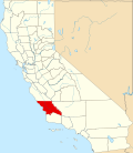
Location of Grover Beach in San Luis Obispo County, California.
Usa edcp relief location map.png
Red pog.svg
Grover Beach, California
Location in the United States
Coordinates: 35°7′15″N120°37′10″W / 35.12083°N 120.61944°W / 35.12083; -120.61944
Country Flag of the United States (23px).png  United States
State Flag of California.svg  California
County San Luis Obispo
Incorporated December 21, 1959 [2]
Named for D.W. Grover
Government
  Type Council–manager [3]
  BodyGrover Beach City Council
   Mayor Karen Bright [4]
   City Manager Matthew Bronson [5]
  Council Members [4]
List
   Assemblymember Dawn Addis (D)
   State Senator John Laird (D) [6]
Area
[7]
  Total2.32 sq mi (6.00 km2)
  Land2.31 sq mi (5.99 km2)
  Water0.00 sq mi (0.01 km2)  0.19%
Elevation
[8]
59 ft (18 m)
Population
 (2020) [9]
  Total12,701
  Density5,493.5/sq mi (2,121.1/km2)
Time zone UTC-8 (Pacific)
  Summer (DST) UTC-7 (PDT)
ZIP codes
93433, 93483
Area code 805
FIPS code 06-31393
GNIS feature ID 1652833
Website www.grover.org

Grover Beach is a city in San Luis Obispo County, California, United States. The population was 12,701 at the 2020 census, down from 13,156 in 2010. Grover Beach is the location of the Pacific Crossing cable Landing station. This is where trans-pacific submarine communications cables come ashore and interface with the North American telecom network. [10]

Contents

History

Grover Beach was originally known as Town of Grover, which was founded on August 1, 1887. The town was named for its founder, D.W. Grover. [11]

Grover filed his plans at the San Luis Obispo County Court House and eventually founded what was to be known as City of Grover City. There was a popular vote that allowed incorporating on December 21, 1959, as City of Grover City. However, the name seemed redundant so some people sought better names, especially ocean-oriented names. In 1992, there was another popular vote, in which the town's name was officially changed from "City of Grover City" to "Grover Beach" to emphasize the seaside location. [12]

Geography

Grover Beach is part of the 5 Cities Metropolitan Area. The "5 Cities" includes 3 cities; Grover Beach, Pismo Beach, and Arroyo Grande along with Oceano and Shell Beach (part of Pismo Beach). The city extends from Arroyo Grande in the east to Pismo State Beach.

According to the United States Census Bureau, the city has a total area of 2.3 square miles (6.0 km2), of which 99.81% is land and 0.19% is water.

Climate

This region experiences warm and dry summers, with no average monthly temperatures above 71.6 °F. According to the Köppen Climate Classification system, Grover Beach has a warm-summer Mediterranean climate, abbreviated "Csb" on climate maps. [13]

Climate data for Grover Beach, California
MonthJanFebMarAprMayJunJulAugSepOctNovDecYear
Mean daily maximum °F (°C)61.5
(16.4)
62.3
(16.8)
63.6
(17.6)
66.4
(19.1)
68.7
(20.4)
71.1
(21.7)
72.6
(22.6)
74.0
(23.3)
74.1
(23.4)
72.1
(22.3)
67.3
(19.6)
61.6
(16.4)
67.9
(19.9)
Mean daily minimum °F (°C)42.9
(6.1)
44.3
(6.8)
45.6
(7.6)
46.7
(8.2)
48.8
(9.3)
51.8
(11.0)
54.3
(12.4)
54.7
(12.6)
54.1
(12.3)
51.1
(10.6)
46.6
(8.1)
42.3
(5.7)
48.6
(9.2)
Average precipitation inches (mm)3.44
(87)
3.53
(90)
3.23
(82)
1.05
(27)
0.37
(9.4)
0.06
(1.5)
0.03
(0.76)
0.02
(0.51)
0.31
(7.9)
0.69
(18)
1.55
(39)
2.47
(63)
16.75
(426.07)
Source 1: [14]
Source 2: [15]

Demographics

Historical population
CensusPop.Note
1960 5,210
1970 5,93914.0%
1980 8,82748.6%
1990 11,65632.0%
2000 13,06712.1%
2010 13,1560.7%
2020 12,701−3.5%
2022 (est.)12,619 [16] −0.6%
U.S. Decennial Census [17]

2010

At the 2010 census, Grover Beach had a population of 13,156. The population density was 5,684.2 inhabitants per square mile (2,194.7/km2). The racial makeup of Grover Beach was 9,964 (75.7%) White, 146 (1.1%) African American, 186 (1.4%) Native American, 542 (4.1%) Asian, 35 (0.3%) Pacific Islander, 1,582 (12.0%) from other races, and 701 (5.3%) from two or more races. Hispanic or Latino of any race were 3,840 persons (29.2%). [18]

The census reported that 12,967 people (98.6% of the population) lived in households, 185 (1.4%) lived in non-institutionalized group quarters, and 4 (0.0%) were institutionalized.

There were 5,111 households, 1,656 (32.4%) had children under the age of 18 living in them, 2,178 (42.6%) were opposite-sex married couples living together, 735 (14.4%) had a female householder with no husband present, 335 (6.6%) had a male householder with no wife present. There were 428 (8.4%) unmarried opposite-sex partnerships, and 54 (1.1%) same-sex married couples or partnerships. 1,330 households (26.0%) were one person and 439 (8.6%) had someone living alone who was 65 or older. The average household size was 2.54. There were 3,248 families (63.5% of households); the average family size was 3.04.

The age distribution was 2,928 people (22.3%) under the age of 18, 1,264 people (9.6%) aged 18 to 24, 3,809 people (29.0%) aged 25 to 44, 3,603 people (27.4%) aged 45 to 64, and 1,552 people (11.8%) who were 65 or older. The median age was 36.9 years. For every 100 females, there were 95.7 males. For every 100 females aged 18 and over, there were 93.6 males.

There were 5,748 housing units at an average density of 2,483.5 per square mile, of the occupied units 2,390 (46.8%) were owner-occupied and 2,721 (53.2%) were rented. The homeowner vacancy rate was 2.0%; the rental vacancy rate was 3.7%. 5,719 people (43.5% of the population) lived in owner-occupied housing units and 7,248 people (55.1%) lived in rental housing units.

2000

At the 2000 census, there were 13,067 people in 5,023 households, including 3,305 families, in the city. The population density was 5,637.4 inhabitants per square mile (2,176.6/km2). There were 5,382 housing units at an average density of 2,321.9 units per square mile (896.5 units/km2). The racial makeup of the city was 79.75% White, 1.03% African American, 1.69% Native American, 3.75% Asian, 0.30% Pacific Islander, 9.23% from other races, and 4.25% from two or more races. Hispanic or Latino of any race were 22.51%. [19]

Of the 5,023 households 32.8% had children under the age of 18 living with them, 46.9% were married couples living together, 14.1% had a female householder with no husband present, and 34.2% were non-families. 24.6% of households were one person and 8.2% were one person aged 65 or older. The average household size was 2.58 and the average family size was 3.07.

The age distribution was 25.6% under the age of 18, 9.1% from 18 to 24, 32.0% from 25 to 44, 21.7% from 45 to 64, and 11.5% 65 or older. The median age was 35 years. For every 100 females, there were 94.1 males. For every 100 females aged 18 and over, there were 89.9 males.

The median household income was $38,087 and the median family income was $41,859. Males had a median income of $31,045 versus $26,506 for females. The per capita income for the city was $18,812. About 8.8% of families and 11.3% of the population were below the poverty line, including 12.0% of those under age 18 and 8.1% of those age 65 or over.

Government

In the California State Legislature, Grover Beach is in the 17th Senate District , represented by Democrat John Laird, and in the 30th Assembly District , represented by Democrat Dawn Addis. [20]

In the United States House of Representatives, Grover Beach is in California's 24th congressional district , represented by Democrat Salud Carbajal. [21]

Transportation

Grover Beach Amtrak Grover Beach Amtrak.JPG
Grover Beach Amtrak

The Grover Beach station is the only rail station in the five cities area, and is located at the intersection of Grand Avenue and State Highway 1, adjacent to Pismo State Beach.

Amtrak Thruway 18 provides a daily connection to Visalia on the east, and Santa Maria on the west, with several stops in between. [22] These buses depart from the stop situated directly across the tracks. A recent expansion of the station has moved the bus stop to the west side of the tracks, adjacent to the station building.

San Luis Obispo Regional Transit Authority operates additional bus lines that run from Grover Beach to most cities in San Luis Obispo county, as well as Santa Maria.

Related Research Articles

<span class="mw-page-title-main">San Luis Obispo County, California</span> County in California, United States

San Luis Obispo County, officially the County of San Luis Obispo, is a county on the Central Coast of California. As of the 2020 census, the population was 282,424. The county seat is San Luis Obispo.

<span class="mw-page-title-main">Ashland, California</span> Unincorporated community in California, United States

Ashland is a census-designated place (CDP) and unincorporated community in Alameda County, California, United States. The population was 23,823 at the 2020 census. Ashland is located between the city of San Leandro to the north, the unincorporated community of Cherryland to the south, the unincorporated community of Castro Valley to the east, and the unincorporated community of San Lorenzo to the southwest.

<span class="mw-page-title-main">East Rancho Dominguez, California</span> Unincorporated community in California, United States

East Rancho Dominguez, also known as East Compton, is an unincorporated community and census-designated place (CDP) located in southern Los Angeles County, California. The population was 15,135 at the 2010 census, up from 9,286 at the 2000 census. East Rancho Dominguez is an accepted city name according to the USPS, and shares the 90221 ZIP Code with Compton.

<span class="mw-page-title-main">Bradley, California</span> Unincorporated community in California, United States

Bradley is an unincorporated community and census-designated place (CDP) in Monterey County, California, on the Salinas River 14 miles (23 km) south-southeast of San Ardo and 20 miles (32 km) north of Paso Robles. Bradley sits at an elevation of 548 feet (167 m). The population was 69 at the 2020 census, down from 93 at the 2010 census.

<span class="mw-page-title-main">Westminster, California</span> City in California, United States

Westminster is a city in western Orange County, California, United States. Westminster was founded in 1870 by Rev. Lemuel Webber as a Presbyterian temperance colony and was incorporated in 1957.

<span class="mw-page-title-main">Highland, California</span> City in California, United States

Highland is a city in San Bernardino County, California, United States. The city's population was 56,999 at the 2020 census.

<span class="mw-page-title-main">Arroyo Grande, California</span> City in California, United States

Arroyo Grande is a city in San Luis Obispo County, California, United States. The population was 18,441 as of the 2020 census, up from 17,252 as of the 2010 census.

<span class="mw-page-title-main">Atascadero, California</span> City in California, United States

Atascadero is a city in San Luis Obispo County, California, United States, located on U.S. Route 101. Atascadero is part of the San Luis Obispo-Paso Robles metropolitan statistical area, which encompasses the extents of the county. Atascadero is farther inland than most other cities in the county, and as a result, usually experiences warmer, drier summers, and cooler winters than other nearby cities such as San Luis Obispo and Pismo Beach. The main freeway through town is U.S. 101. The nearby State Routes 41 and 46 provide access to the Pacific Coast and the Central Valley of California.

<span class="mw-page-title-main">Cambria, California</span> Place in California, United States

Cambria is a seaside village in San Luis Obispo County, California, United States midway between San Francisco and Los Angeles along California State Route 1. The name Cambria, chosen in 1869, is the Latin name for Wales. Cambria is situated amidst Monterey pines in one of only three such native forests. The town previously had gone by the names of Slabtown, Rosaville, San Simeon, and Santa Rosa.

<span class="mw-page-title-main">Cayucos, California</span> Unincorporated community in California, United States

Cayucos is an unincorporated coastal town in San Luis Obispo County, California, along California State Route 1 between Cambria to the north and Morro Bay to the south. The population was 2,505 at the 2020 census, down from 2,592 at the 2010 census.

<span class="mw-page-title-main">Morro Bay, California</span> City in California, United States

Morro Bay is a seaside city in San Luis Obispo County, California, United States. Located on the Central Coast of California, the city population was 10,757 as of the 2020 census, up from 10,234 at the 2010 census. The town overlooks Morro Bay, a natural embayment with an all-weather small craft commercial and recreational harbor.

<span class="mw-page-title-main">Nipomo, California</span> Place in California, United States

Nipomo is an unincorporated town in San Luis Obispo County, California, United States. The population was 16,714 for the 2010 census and grew to 18,176 for the 2020 census. For statistical purposes, the United States Census Bureau has defined Nipomo as a census-designated place (CDP).

<span class="mw-page-title-main">Oceano, California</span> Census designated place in California, United States

Oceano is a census-designated place (CDP) in San Luis Obispo County, California, United States. The population was 7,183 at the 2020 census, down from 7,286 at the 2010 census.

<span class="mw-page-title-main">Pismo Beach, California</span> City in California, United States

Pismo Beach is a city in the southern portion of San Luis Obispo County, in the Central Coast area of California, United States. Its estimated population was 8,072 at the 2020 census, up from 7,655 in the 2010 census. It is part of the Five Cities area, a cluster of cities in that area. The Five Cities area historically is made up of Arroyo Grande, Grover City, Halcyon, Fair Oaks, and Nipomo. Now most people refer to the Five Cities as Grover Beach, Pismo Beach, Shell Beach, Arroyo Grande, and Oceano.

Bret Harte is a census-designated place (CDP) in Stanislaus County, California, United States. The population was 5,152 at the 2010 census, down from 5,161 at the 2000 census. It is part of the Modesto Metropolitan Statistical Area. It is named for the American poet and short story writer, Bret Harte, best known for his writings about the California Gold Rush.

<span class="mw-page-title-main">Bystrom, California</span> Census-designated place in California, United States

Bystrom is a census-designated place (CDP) in Stanislaus County, California, United States. The population was 4,008 at the 2010 census, down from 4,518 at the 2000 census. It is part of the Modesto Metropolitan Statistical Area.

<span class="mw-page-title-main">Ida Grove, Iowa</span> City in Iowa, United States

Ida Grove is a city in Ida County, Iowa, United States. The population was 2,051 at the time of the 2020 census. It is the county seat of Ida County.

<span class="mw-page-title-main">Del Monte Forest, California</span> Census-designated place in California, United States

Del Monte Forest is a census-designated place (CDP) in Monterey County, California, United States. As of the 2020 census, the CDP had a total population of 4,204, down from 4,514 at the 2010 census. The census area includes the separate well-known community of Pebble Beach.

<span class="mw-page-title-main">Channel Islands Beach, California</span> Place in California, United States

Channel Islands Beach is an unincorporated community in Ventura County, California, United States consisting of three historic neighborhoods: Hollywood Beach, Hollywood by the Sea, and Silver Strand Beach. This densely populated narrow 1.3-mile-long strip (2.1 km) along the coastal edge of the Oxnard Plain was subdivided using the glamor of Hollywood to sell lots in the mid-1920s since the sand dunes had been used for movies. Adjacent development has left this sandy beachfront neighborhood hemmed in by Channel Islands Harbor and Naval Base Ventura County. The harbor mouth separates them into two communities resulting in a round-about travel route around the harbor between them although the Channel Islands Beach Community Services District provides local utilities services to the entire neighborhood. The Special-purpose district has an elected Board of Directors which provides a forum for the unique concerns of the community. Lying immediately adjacent but outside the corporate boundaries of the City of Oxnard and the City of Port Hueneme, they are governed by the county Board of Supervisors.

<span class="mw-page-title-main">Avila Beach, California</span> Place in California, United States

Avila Beach is an unincorporated community in San Luis Obispo County, California, United States, located on San Luis Obispo Bay about 160 miles (257 km) northwest of Los Angeles, and about 200 miles (320 km) south of San Francisco. The population was 1,576 at the 2010 census. For statistical purposes, the United States Census Bureau has defined Avila Beach as a census-designated place (CDP).

References

  1. "Official Website of Grover Beach, California". Official Website of Grover Beach, California. Retrieved September 6, 2012.
  2. "California Cities by Incorporation Date". California Association of Local Agency Formation Commissions. Archived from the original (Word) on November 3, 2014. Retrieved August 25, 2014.
  3. "Grover Beach, CA – Official Website - City Council". City of Grover Beach. Retrieved November 1, 2018.
  4. 1 2 "City Council Members". City of Grover Beach. Retrieved November 2, 2018.
  5. "City Manager's Office". City of Grover Beach. Retrieved November 2, 2018.
  6. "Statewide Database". UC Regents. Archived from the original on February 1, 2015. Retrieved November 18, 2014.
  7. "2019 U.S. Gazetteer Files". United States Census Bureau. Retrieved July 1, 2020.
  8. "Grover Beach". Geographic Names Information System . United States Geological Survey, United States Department of the Interior . Retrieved February 24, 2015.
  9. "Grover Beach (city) QuickFacts". United States Census Bureau . Retrieved March 23, 2024.
  10. "Grover Beach Cable Landing Station - Submarine Networks".
  11. "Profile for Grover Beach, California, CA". ePodunk. Archived from the original on June 25, 2017. Retrieved September 6, 2012.
  12. History of Grover Beach, CA Archived June 14, 2009, at the Wayback Machine accessed September 4, 2009
  13. Climate Summary for Grover Beach, California
  14. "Zipcode 93483". www.plantmaps.com. Retrieved February 15, 2022.
  15. "Grover Beach, California Climate". www.bestplaces.net. Retrieved February 15, 2022.
  16. "Population and Housing Unit Estimates". United States Census Bureau. July 1, 2022. Retrieved June 28, 2023.
  17. "Census of Population and Housing". Census.gov. Retrieved June 28, 2023.
  18. "2010 Census Interactive Population Search: CA - Grover Beach city". U.S. Census Bureau. Archived from the original on July 15, 2014. Retrieved July 12, 2014.
  19. "U.S. Census website". United States Census Bureau . Retrieved January 31, 2008.
  20. "Final Maps". State of California. Retrieved June 27, 2023.
  21. "California's 24th Congressional District - Representatives & District Map". Civic Impulse, LLC. Retrieved September 29, 2014.
  22. "Route18".