Hanover, Ohio

Last updated

Hanover, Ohio
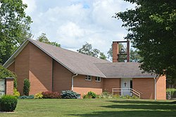
Hanover PCUSA on Main.jpg
Presbyterian church
OHMap-doton-Hanover.png
Location of Hanover, Ohio
Licking County, Ohio highlighting Hanover village.svg
Location within Licking County
Coordinates: 40°04′55″N82°16′34″W / 40.08194°N 82.27611°W / 40.08194; -82.27611
Country United States
State Ohio
County Licking
Area
[1]
  Total1.84 sq mi (4.78 km2)
  Land1.83 sq mi (4.73 km2)
  Water0.02 sq mi (0.05 km2)
Elevation
[2]
807 ft (246 m)
Population
 (2020)
  Total1,270
  Estimate 
(2023) [3]
1,317
  Density695.13/sq mi (268.39/km2)
Time zone UTC-5 (Eastern (EST))
  Summer (DST) UTC-4 (EDT)
FIPS code 39-33292 [4]
GNIS feature ID2398241 [2]

Hanover is a village in Licking County, Ohio, United States. The population was 1,270 at the 2020 census. The village lies along Ohio State Route 16.

Contents

History

Hanover was laid out in 1849, although there had been business activity at the site for some time. [5] An early variant name was Fleming, for John Fleming, the original owner of the town site. [6]

Geography

According to the United States Census Bureau, the village has a total area of 1.68 square miles (4.35 km2), of which 1.66 square miles (4.30 km2) is land and 0.02 square miles (0.05 km2) is water. [7]

Demographics

Historical population
CensusPop.Note
1870 322
1880 302−6.2%
1890 288−4.6%
1900 3149.0%
1910 3315.4%
1920 321−3.0%
1930 35510.6%
1940 325−8.5%
1950 308−5.2%
1960 267−13.3%
1970 626134.5%
1980 92647.9%
1990 803−13.3%
2000 88510.2%
2010 9214.1%
2020 1,27037.9%
2023 (est.)1,317 [3] 3.7%
U.S. Decennial Census [8]

2010 census

As of the census [9] of 2010, there were 921 people, 323 households, and 253 families living in the village. The population density was 554.8 inhabitants per square mile (214.2/km2). There were 334 housing units at an average density of 201.2 per square mile (77.7/km2). The racial makeup of the village was 97.5% White, 1.0% African American, 0.3% Native American, 0.2% Asian, 0.4% from other races, and 0.5% from two or more races. Hispanic or Latino of any race were 0.7% of the population.

There were 323 households, of which 42.7% had children under the age of 18 living with them, 64.1% were married couples living together, 11.5% had a female householder with no husband present, 2.8% had a male householder with no wife present, and 21.7% were non-families. 17.0% of all households were made up of individuals, and 9.3% had someone living alone who was 65 years of age or older. The average household size was 2.85 and the average family size was 3.21.

The median age in the village was 37.5 years. 29.3% of residents were under the age of 18; 6.9% were between the ages of 18 and 24; 23.7% were from 25 to 44; 26.3% were from 45 to 64; and 13.8% were 65 years of age or older. The gender makeup of the village was 51.8% male and 48.2% female.

2000 census

As of the census [4] of 2000, there were 885 people, 314 households, and 258 families living in the village. The population density was 885.2 inhabitants per square mile (341.8/km2). There were 328 housing units at an average density of 328.1 per square mile (126.7/km2). The racial makeup of the village was 98.53% White, 0.45% African American, 0.23% Native American, 0.23% from other races, and 0.56% from two or more races. Hispanic or Latino of any race were 0.23% of the population.

There were 314 households, out of which 41.4% had children under the age of 18 living with them, 69.4% were married couples living together, 10.2% had a female householder with no husband present, and 17.8% were non-families. 15.0% of all households were made up of individuals, and 6.7% had someone living alone who was 65 years of age or older. The average household size was 2.82 and the average family size was 3.10.

In the village, the population was spread out, with 27.7% under the age of 18, 9.3% from 18 to 24, 27.9% from 25 to 44, 24.7% from 45 to 64, and 10.4% who were 65 years of age or older. The median age was 37 years. For every 100 females there were 102.5 males. For every 100 females age 18 and over, there were 95.7 males.

The median income for a household in the village was $50,313, and the median income for a family was $53,438. Males had a median income of $39,048 versus $23,854 for females. The per capita income for the village was $20,679. About 3.9% of families and 4.4% of the population were below the poverty line, including 4.5% of those under age 18 and 5.0% of those age 65 or over.
Related Research Articles

<span class="mw-page-title-main">Hanover, Michigan</span> Village in Michigan, United States

Hanover is a village in Jackson County in the U.S. state of Michigan. The population was 441 at the 2010 census. The village is located within Hanover Township.

<span class="mw-page-title-main">Fort Shawnee, Ohio</span> CDP in Ohio, United States

Fort Shawnee is census-designated place (CDP) in Allen County, Ohio, United States. The population was 6,263 at the 2020 census. It is included in the Lima, Ohio Metropolitan Statistical Area. Fort Shawnee is adjacent to the city of Lima and the village of Cridersville in Auglaize County. In 2012, village residents voted to disincorporate the village. According to the United States Census Bureau, the village had a total area of 7.25 square miles (18.78 km2), of which 7.21 square miles (18.67 km2) is land and 0.04 square miles (0.10 km2) is water.

<span class="mw-page-title-main">Brookside, Ohio</span> Village in Ohio, United States

Brookside is a village in eastern Belmont County, Ohio, United States. The population was 538 at the 2020 census. It is part of the Wheeling metropolitan area.

<span class="mw-page-title-main">Flushing, Ohio</span> Village in Ohio, United States

Flushing is a village in Belmont County, Ohio, United States. The population was 830 at the 2020 census.

<span class="mw-page-title-main">Aberdeen, Ohio</span> Village in Ohio, United States

Aberdeen is a village in Huntington Township, Brown County, Ohio, United States, along the Ohio River 50 miles (80 km) southeast of Cincinnati. The population was 1,515 at the 2020 census.

<span class="mw-page-title-main">New Washington, Ohio</span> Village in Ohio, United States

New Washington is a village in Cranberry Township in Crawford County, Ohio, United States. The population was 873 at the 2020 census.

<span class="mw-page-title-main">Lyons, Ohio</span> Village in Ohio, United States

Lyons is a village in Fulton County, Ohio, United States. The population was 602 at the 2020 census.

<span class="mw-page-title-main">Crown City, Ohio</span> Village in Ohio, United States

Crown City is a village in Gallia County, Ohio, United States, along the Ohio River. The population was 424 at the 2020 census.

<span class="mw-page-title-main">Cumberland, Ohio</span> Village in Guernsey County, Ohio, United States

Cumberland is a village in Guernsey County, Ohio, United States. It is seventy miles east of Columbus. The population was 317 at the 2020 census.

<span class="mw-page-title-main">Addyston, Ohio</span> Village in Ohio, United States

Addyston is a village in Miami Township, Hamilton County, Ohio, United States. Located along the Ohio River, it is a western suburb of the neighboring city of Cincinnati. The population was 927 at the 2020 census.

<span class="mw-page-title-main">Woodlawn, Ohio</span> Village in Ohio, United States

Woodlawn is a village in Hamilton County, Ohio, United States. The population was 3,916 at the 2020 census.

<span class="mw-page-title-main">Martinsburg, Ohio</span> Village in Ohio, United States

Martinsburg is a village in Knox County, Ohio, United States. The population was 222 at the 2020 census.

<span class="mw-page-title-main">Hebron, Ohio</span> Village in Ohio, USA

Hebron is a village in Licking County, Ohio, United States. The population was 2,326 at the 2020 census.

<span class="mw-page-title-main">Clarksburg, Ohio</span> Village in Ohio, United States

Clarksburg is a village in Ross County, Ohio, United States. The population was 409 at the 2020 census.

<span class="mw-page-title-main">Orangeville, Ohio</span> Village in Ohio, United States

Orangeville is a village in eastern Trumbull County, Ohio, United States, along the state line with Pennsylvania. The population was 174 at the 2020 census. It is part of the Youngstown–Warren metropolitan area.

<span class="mw-page-title-main">Port Washington, Ohio</span> Village in Ohio, United States

Port Washington is a village in Tuscarawas County, Ohio, United States. The population was 548 at the 2020 census.

<span class="mw-page-title-main">Haskins, Ohio</span> Village in Ohio, United States

Haskins is a village in Wood County, Ohio, United States. The population was 1,245 at the 2020 census.

<span class="mw-page-title-main">Wilson, Ohio</span> Village in Ohio, United States

Wilson is a village in Belmont and Monroe counties in the U.S. state of Ohio. The population was 129 at the 2020 census. It is part of the Wheeling metropolitan area.

<span class="mw-page-title-main">Gratiot, Ohio</span> Village in Ohio, United States

Gratiot is a village in Licking and Muskingum counties in the U.S. state of Ohio. The population was 215 at the 2020 census.

<span class="mw-page-title-main">Verona, Ohio</span> Village in Ohio, United States

Verona is a village in Montgomery and Preble counties in the U.S. state of Ohio. The population was 403 at the 2020 census. It is part of the Dayton Metropolitan Statistical Area.

References

  1. "ArcGIS REST Services Directory". United States Census Bureau. Retrieved September 20, 2022.
  2. 1 2 U.S. Geological Survey Geographic Names Information System: Hanover, Ohio
  3. 1 2 "Annual Estimates of the Resident Population for Incorporated Places in Ohio: April 1, 2020 to July 1, 2023". United States Census Bureau. Retrieved July 8, 2024.
  4. 1 2 "U.S. Census website". United States Census Bureau . Retrieved January 31, 2008.
  5. Brister, Edwin M. P. (1909). Centennial History of the City of Newark and Licking County, Ohio. S.J. Clarke Publishing Company. p. 255.
  6. Overman, William Daniel (1958). Ohio Town Names. Akron, OH: Atlantic Press. p. 57.
  7. "US Gazetteer files 2010". United States Census Bureau . Retrieved January 6, 2013.
  8. "Census of Population and Housing". Census.gov. Retrieved June 4, 2015.
  9. "U.S. Census website". United States Census Bureau . Retrieved January 6, 2013.